Showing 27536 items
matching yarra-river
-
 Ballarat Heritage Services
Photograph - Black and White, Kit Fitzgerald, Doris Long, Mick Fitzgerald and Doris Long
Possibly related to the Long family of South Yarra. Three black and white photos of two women in bathing costumes and swimming caps, and a man sitting to two children. They stand/sit in front of bathing boxes (possible St Kilda or Brighton) long, swimming, bathing costume, bathing box -
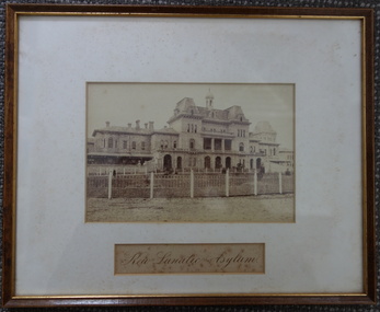 Kew Historical Society Inc
Photograph, Charles Nettleton, Kew Lunatic Asylum, c.1886
Following a Royal Commission in 1854, the building of a new Asylum at Kew began in 1864. It was built to replace the Yarra Bend Asylum on the Fairfield side of the Yarra River. Work started in 1864 and was completed in 1872 at a cost of ₤198,334. Operating over a period of 116 years, and often renamed to take account of public sensitivities, the ‘Kew Lunatic Asylum’ was one of the largest asylums built in Australia. ‘Willsmere’ was finally closed in December 1988 and sold by the Government of Victoria in the late 1980s. The photograph is by Charles Nettleton. He arrived in Victoria in 1854. In Melbourne he joined the studio of T. Duryea and Alexander McDonald and specialized in outdoor work. ... Nettleton opened his own studio in 1858. His souvenir albums were the first of the type to be offered to the public. However, when the dry-plate came into general use in 1885 he knew that the new process offered opportunities that were beyond his scope. Five years later his studio was closed (Source: ADB)A rare silver albumen photograph by the Victorian photographer Charles Nettleton.A framed original silver albumen photograph by Charles Nettleton showing the front of the Kew Lunatic Asylum.KEW LUNATIC ASYLUMkew lunatic asylum, studley park, charles nettleton, asylum, willsmere hospital, willsmere mental hospital, lunatic -
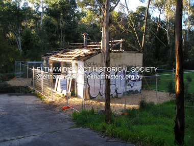 Eltham District Historical Society Inc
Photograph, Fay Bridge, Warrandyte cool store, 9 September 2019
Remains of the old Warrandyte Dairy — Originally constructed to store milk for delivery from Mapleoak Dairies, delivered by the Bellinger family, up until the early 1970s. The Warrandyte Dairy closed in 1987 before the land and building was purchased by Melbourne Water in 1988 to reduce flood risk to the community and preserve riverside land from development on the site which sits on the Yarra River flood plain. In 2017, through a partnership with Manningham City Council, Warrandyte Historical Society and the Warrandyte Community Association, Melbourne Water renovated the 73-year-old site and installed interpretive signs detailing its history for the community.2019-09-09, fay bridge collection, warrandyte cool store, warrandyte dairy -
 Eltham District Historical Society Inc
Photograph - Aerial Photograph, Landata, Lower Plenty, Feb. 1956
Centred on present day 217 Old Eltham Road, Lower Plenty bounded by Pitt Street to north, Yarra River to south, Main Road to east and Bonds Road to west. Historic Aerial Imagery Source: Landata.vic.gov.au Aerial Photo Details: Project No :250 Project : MELBOURNE OUTER SUBURBS PROJECT Run : 17 Frame : 116 Date : 02/1956 Film Type : B/W Camera : EAG9 Flying Height : 10000 Scale : 12000 Film Number : 1176 GDA2020 : 37°43'58"S, 145°07'49"E MGA2020 : 335237, 5822186 (55) Melways : 21 E10 (ed. 42)aerial photo, 1956-02, neil webster collection, eltham, main road, bonds road, elham, lower plenty, melway 21e10, pitt street, yarra river -
 Eltham District Historical Society Inc
Photograph - Aerial Photograph, Landata, Eltham, Vic, Apr. 1963
Centred on present day Griffith Park Road, Eltham bounded by Mount Pleasant Road to north, Yarra River and Templestowe to south, Main Road at Reynolds Road to east and Falkiner Street to west. Historic Aerial Imagery Source: Landata.vic.gov.au Aerial Photo Details: Project No :486 Project : MELBOURNE (1963) PROJECT Run : 7 Frame : 233 Date : 04/1963 Film Type : B/W Camera : RC8 Flying Height : 5100 Scale : 9600 Film Number : 1805 GDA2020 : 37°44'04"S, 145°09'10"E MGA2020 : 337237, 5822053 (55) Melways : 22 A10 (ed. 42)aerial photo, neil webster collection, 1963-04, eltham, falkiner street, griffith park road, melway 22a10, mount pleasant road, reynolds road, templestowe, yarra river -
 Eltham District Historical Society Inc
Photograph - Aerial Photograph, Landata, Eltham, Vic, Apr. 1972
Centred on present day Dalton Street at Mount Pleasant Road, Eltham bounded by Arthur Street to north, Yarra River and Kent Hughes Road to south, Eucalyptus Road to east and Susan Street to west. Historic Aerial Imagery Source: Landata.vic.gov.au Aerial Photo Details: Project No :985 Project : MELBOURNE 1972 Run : 28 Frame : 208 Date : 04/1972 Film Type : B/W Camera : RC10 Flying Height : 5700 Scale : 9600 Film Number : 2635 GDA2020 : 37°43'29"S, 145°08'54"E MGA2020 : 336816, 5823118 (55) Melways : 21 J8 (ed. 42)aerial photo, neil webster collection, 1972-04, eltham, arthur street, dalton street, eucalyptus road, kent hughes road, melway 21j8, mount pleasant road, susan street, yarra river -
 Eltham District Historical Society Inc
Photograph, 1934 Floods at Eltham
Published in the Diamond Creek Basin Study, 1980 and identified at Diamond Creek, locality not identified, 1934. The location is actually looking south across the Diamond Creek towards Falkiner Street, beside the Main Road bridge at Eltham South from what is now part of Wingrove Park opposite Antoinette Boulevard. The bridge railing is just visible to the left of image. The large leaning Manna Gum beside the bridge still stands in 2021 alongside the Diamond Creek trail. In 1934 extensive flooding of the Yarra River and Diamond Creek set new records for flood plain level (Eltham Chronology, EDHS)Black and white photographCopied by Hugh Fisher, Photographer, 6 York Street Eltham A1678B Floods- Eltham - 1934floods, yarra river, eltham, flooding, diamond creek, flood -
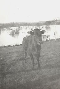 Kew Historical Society Inc
Photograph, Cattle in North Kew floods, 1934
The year 1934 witnessed the greatest flooding of the Yarra River since settlement. This work forms part of the collection assembled by the historian Dorothy Rogers, that was donated to the Kew Historical Society by her son John Rogers in 2015. The manuscripts, photographs, maps, and documents were sourced by her from both family and local collections or produced as references for her print publications. Many were directly used by Rogers in writing ‘Lovely Old Homes of Kew’ (1961) and 'A History of Kew' (1973), or the numerous articles on local history that she produced for suburban newspapers. Most of the photographs in the collection include detailed annotations in her hand. The Rogers Collection provides a comprehensive insight into the working habits of a historian in the 1960s and 1970s. Together it forms the largest privately-donated collection within the archives of the Kew Historical Society.Photograph of floodwaters encroaching on farm land in North Kew in the flood of 1934.Nth. Kew. 1934 Floodsfloods (melbourne) 1934, dorothy rogers -
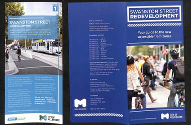 Melbourne Tram Museum
Pamphlet, VicRoads, "Swanston Street Proposed Tram Project", 2010 to 2011
Set of five pamphlets associated with the installation of Superstops with a bike path in Swanston St during 2010 and 2012. .1 - DL - General redevelopment - Stage 1 - general pamphlet, Published by City of Melbourne and Yarra Trams. 2 - DL - double fold - guide to the new accessible tram zones - City of Melbourne, mainly around the new bike lane arrangements. 3 - DL - tri fold - Information Update 1 - giving an outline of the proposed staging of the works, service changes and dates for works during 2011. Has logos for Yarra, VicRoads, State Government and think tram. 4 - DL - two fold - Tram service changes, for all Swanston St routes, May 2011 with a photo of C1 3525 on the front cover. 5 - DL - six fold - August 2010 - project survey, outlining project for Franklin St to Grattan St Carlton. Has logos for Yarra, VicRoads and think tram.trams, tramways, swanston st walk, swanston st, trackwork, city of melbourne, franklin st, carlton, proposals, tram 3525 -
 Orbost & District Historical Society
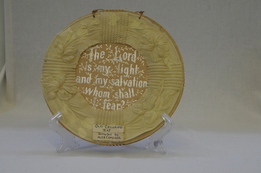
ornament, late 19th - first half 20th century
Owned by Alexander Cameron who arrived in Australia in 1853. Alexander Cameron ("Big Alex") was an early settler on the Snowy River flats. he worked the paddle steamer Cheviot for a while, having a wharf and sheds on the Snowy River in 1900. Later moved to Cann River.This item is an example of a handcrafted religious ornament of the late 19th-early 20th century.Handmade, round, religious text ornament of celluloid and cardboard with silver writing.Front - "The Lord is my light and my salvation, whom shall I fear?"ornament handmade religious -
 Wodonga & District Historical Society Inc
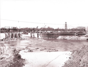
Album - Hume Reservoir Australia Album - Section of completed coffer dam, January 1927, 1927
This set of photos is from a leather bound album bearing the inscription "HUME RESERVOIR AUSTRALIA" plus 'The Rt. Hon. L. C. M. S. Amery, P. C., M .P.' all inscribed in gold. It was presented to The Rt. Hon. L. C. M. S. Amery, P. C., M. P, Secretary of State for Dominion Affairs on the occasion of his visit to the Hume Reservoir on 2nd November 1927. This album is of local and national significance as it documents the planning and development of the Hume Reservoir up to 1927. It was the largest water reservoir in the British Empire. The album records the pioneering engineering work that went into its construction.DEPARTMENT OF PUBLIC WORKS, N.S.W. RIVER MURRAY WATERS SCHEME. HUME RESERVOIR. 20. Section of completed coffer dam with river diverted over the concrete foundations of dam that were placed during the first stage of operations. New South Wales. January 1927. Cofferdams are temporary structures used where construction is being carried out in areas submerged in water. They are most commonly used to facilitate the construction or repair of dams, piers and bridges. To divert the river, a Coffer Dam was built across the old bed above and below the Dam site and tying into the end of the concrete wall built inside the levee bank. This completely surrounded the remainder of the site of the Dam and south wing wall, including an area of 12½ acres. hume reservoir australia, river murray waters scheme, hume reservoir construction -
 Orbost & District Historical Society
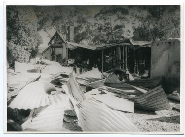
Photograph - Bemm River hotel fire
Bemm River is a small township in East Gippsland. There have been several Bemm River hotels since 1891 when the first Hotel was built by Henry Summer. This Hotel was located near a ford where traffic crossed the river. Annie Morgan was the next person to have a roadside licence to sell liquor at Bemm River, also known as Sydenham Inlet Hotel. In 1927, a hotel was built on the present site at Bemm River, again with the Morgan family. Like many hotels, the Bemm River hotel has burned down or suffered damage through fires and was rebuilt. These photos are likely of a fire at the Hotel in 1994 which resulted in the hotel burning down. It was re-built in 2000 on the same site.History of Bemm River and its hotel5 b/w photos showing a building with severe fire damage, and two people in front of the photos (probably owners).nonebemm river, fire, hotels -
 Greensborough Historical Society
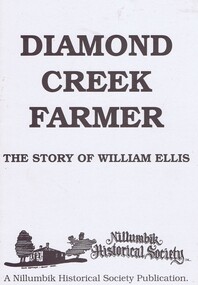
Book, Diamond Creek Farmer, 1850o
History of the Ellis family in Diamond Creek and Yarra Glen.William Ellis emigrated to Victoria in 1847 and bought most of the Wattle Glen area in 1850. He also had family connections to Kangaroo Ground.A black and white booklet, 12 pages, black and white illus.John Mackey in pencil inside front coverwattle glen, kangaroo ground, nillumbik historical society, william ellis, diamond creek, farming, walters family, ellis cottage -
 City of Kingston
Photograph - Colour, 29 January 1993
Bonbeach is a small beachside suburb located between Chelsea and Carrum. The station was opened in 1926 and was the last to be established in the group from Aspendale to Carrum. Urban growth began after World War II. State primary and high schools were opened in 1958 on land in Breeze Street that was once occupied by The Australian Glass Manufacturers. Immediately east of the school sites is the Patterson River Golf Club. The Bonbeach sports reserve has five ovals and is home to the Bonbeach football and baseball clubs. The suburb borders the Edithvale-Seaford Wetlands which is the remnant site of the Carrum Carrum swamp, once the home of the Bunurong people.Bonbeach was originally a seaside destination for holidaymakers and the housing comprised of holiday homes and gradually more permanent residents. It was not until 1926 that Bonbeach had its own railway station. From 1906 until the late 1940s sand was quarried on the east side of the railway line and used in the manufacture of glass. The Australian Glass Manufacturers sold this land in residential blocks and Bonbeach's permanent population spread from the coastal strip across to the other side of the railway line. Laminated colour aerial photograph of the suburb of Bonbeach and also the southern section of neighbouring Chelsea within the City of Kingston. The extent of this 1993 aerial image includes: Top left - Maury Road at the south end of the Chelsea shopping Centre; Top right - Scotch Parade Chelsea Bottom left - Monica Avenue in Bonbeach; Bottom right - Patterson River Golf Club. Landmarks include St Joseph's Church and Primary School, Chelsea Primary School, Bonbeach Station, Bonbeach Fotball Club sports playing fields and Bonbeach Life Saving Club. The Edithvale Wetlands is featured prominently to the right-hand side of the image. Black typed writing on white adhesive label: No. 6662 Black typed writing on white adhesive label: 26E/6662, 29/1/93, 4.25 pm Black typed writing on white adhesive label: 29-1-93 Black typed writing on white adhesive label: P000109 Circular yellow adhesive sticker bonbeach, chelsea -
 Bendigo Historical Society Inc.
Document - STATE RIVERS AND WATER SUPPLY COMMISSION : CONSTITUTION AND FUNCTIONS
State Rivers and Water Supply Commission. Five page typed foolscap document, stapled, outlining the organisation's constitution and functions. The specific functions mentioned include Storage, Irrigation, Drainage - Flood Protection, Town Water Supply - Trust and Urban, Sewerage, Control, Crown's Rights, 1969 Groundwater Act, River Gauging’s, Survey and Research, Finance, Overseas Work, and Payroll (3500 employees). The document is undated, though some of the statistics given are from 1969.state infrastructure, water supply, coliban system, state rivers and water supply commission. coliban system. -
 Kew Historical Society Inc
Photograph - Wharves and harbour on the Moyne River at Port Fairy, c.1926
Henry Beater Christian (1886-1962) , was a descendant of one of the earliest settler families in Kew. Employed at the Kew Asylum as a 'public servant', he was a skilled amateur photographer, photographing numerous scenes in Kew and on his travels around Victoria. The majority of his photographs date from 1916 to 1929. His finest photographs are housed in two photograph albums. Digital copy of a photograph from page 24 of the 47-page photograph album containing 261 gelatinous silver images, loaned by Diane Washfold with permission given to digitise and hold a copy in our collection. In what would appear to be one of his rare trips to coastal Victoria, Henry Christian took this photo of the wharves and harbour on the Moyne River at Port Fairy in c.1926. The photograph shows the buildings along the river and parts of the township in the distance. henry beater christian (1886-1962), landscape photography, christian-washfold collection, photograph albums, moyne river, port fairy (vic.) -
 Ringwood and District Historical Society
Book, Murray Houghton, Selby Store, Thomson's Gully, Warrandyte, 2010
Full title: "Selby Store", Thomson's Gully, Warrandyte, Constructed for Daisy Hawkes, 1939; Later trading as the "Stonehouse" and today (2010) as "The Yarra Store". A three-part survey of published literatue, with introduction and historical summary prepared for the Warrandyte Historical Society, Inc.With spcial reference to Captain Alfred Selby, owner of "Selby Freehold", Warrandyte; Thomas Hawkes & Family, residents of "Greenham", North Warrandyte; Miss Daisy Hawkes, proprietor of "Selby Store". -
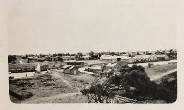
 Upper Yarra Museum
Negative Photographic Reproduction, Building of tramway track
03027 Photograph Building of tramway track Upper Yarra Shire 1888-1988 Centenary collection. Negative, Black & white.Two men with horses digging earth with scoops and then tipping it over the side of the new embankment to make it wide enough for timber traffic to pass by.building tramway track horse scraperscoop -
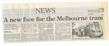 Melbourne Tram Museum
Newspaper, The Age, "A new face for the Melbourne tram", 7/10/2000 12:00:00 AM
Newspaper clipping - titled "A new face for the Melbourne tram", The Age, 7/10/2000 about the new low floor Alstom Citadis trams to be introduced by Yarra Trams for route 109. Item written by Sushi Das. Has an image of the new tramcar.trams, tramways, yarra trams, citadis, alstom, c class -
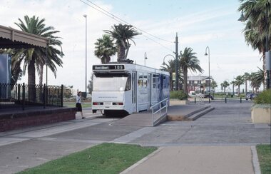 Melbourne Tram Museum
Slide, David Verrier, 5/02/2002 12:00:00 AM
Agfa colour slide, white blue plastic mount. Photograph by David Verrier. Tram A 294 at the Port Melbourne terminus Route 109. Has the Station Pier buildings in the background. Tram in Yarra Trams livery. Photos taken 5/2/2002.In ink: "Tues 5/4/02 294 Route 109 Port Melbourne"trams, tramways, port melbourne, a class, route 109, yarra trams, mont albert, tram 294 -
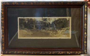 Orbost & District Historical Society
framed black and white photograph, C1920
Boggy Creek Bridge was built in 1916 as part of the Bairnsdale to Orbost extension to the main Gippsland Railway, and is situated in the middle of the township of Nowa Nowa, crossing a steep-sided and well-timbered creek-valley. This section of the line closed in 1987. This item is a pictorial record of the Boggy Creek railway bridge on the East Gippsland line. This bridge plays a major part in the identity and history of the town of Nowa Nowa, since Boggy Creek’s steep sided valley divides the township into two components.A black / white photograph of a bridge across a river in the bush. It is under glass in a brown wooden frame which has gold decorated edges. There appears to be a man sitting on rocks in the right front foreground.on front of photograph - "Nowa Nowa Creek, Gippsland, Victoria, Sears, Copyright"boggy-creek-nowa-nowa east-gippsland-railway bridge-rail -
Glenelg Shire Council Cultural Collection
Map - Map - Glenelg River, 1975
Laminated map, Glenelg River - Casterton, proposed flood level and lines to be designated. Photograph of map taken in 1975. Produced by Rural Water Commission to Shire Engineer, Casterton, attached to reverse of map.flood, flood levels, casterton -
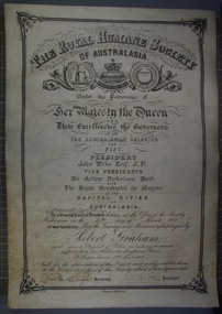 Victoria Police Museum
Certificate and Scroll (Robert Graham), 1888
Black embossed leather scroll with printed and handwritten Royal Humane Society Award Certificate awarded to Robert Graham for rescuing sufferers from the flood at the Goulburn River at Shepparton on 7th November 1887robert graham, greta, kelly gang, ellen kelly, royal humane society, bravery, awards, shepparton -
 Orbost & District Historical Society
black and white photograph, mid 1930s
This is a photograph of McKillop's Bridge probably taken just after its rebuilding. The current McKillop’s Bridge was built by the Country Roads Board in two stages between 1931-36, during which its height was raised after the original bridge superstructure was washed away in record floods of January 1934, prior to its original official opening. In its reconstructed form the original concrete abutments were turned into additional piers and the welded-steel trusses were cantilevered back over them to meet the new higher road approaches. "McKillops Bridge was Heritage listed due to its social and technological significance – the steel trusses' arc-welded construction technique was a pretty big deal in the 1930s. It was once an important route for cattlemen, who used the ford across the Snowy in the years preceding the bridge's existence"This is a pictorial record of McKillop's Bridge just after its construction.A black / white photograph of a wooden bridge across a river. At the bottom right is a man with his back to the camera. He is looking at flood debris on the bank. At the bottom left are two men near a pylon.on back - McKillops Bridgebridge-mckillop's snowy-river-bridge -
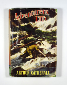 Marysville & District Historical Society
Book, Arthur Catherall, Adventurers, Ltd, 1954
Adventurers, Ltd., was a band of Scouts, all tip-top chaps. they liked to challenge Scouts in neighbouring towns-just to see how good they were. Not one of the Associations they visited ever succeeded in beating Andy, Sam Dodds, Smithy, Fatty Leadfield and the rest, but some of the adventures that came along in the process nearly did! Andy and the haunted tower, for instance; and Dickie Goole and the crashed pilot on the mountain; and the dangerous adventure of the two men in the quicksand. Another first-rate Scouting story by this favourite author.Dust cover has an illustration of a boy scout attempting to cross a flooded river. The reverse of the dust cover has information regarding The Crown Library; a series of school and adventure books for boys and girls.fictionAdventurers, Ltd., was a band of Scouts, all tip-top chaps. they liked to challenge Scouts in neighbouring towns-just to see how good they were. Not one of the Associations they visited ever succeeded in beating Andy, Sam Dodds, Smithy, Fatty Leadfield and the rest, but some of the adventures that came along in the process nearly did! Andy and the haunted tower, for instance; and Dickie Goole and the crashed pilot on the mountain; and the dangerous adventure of the two men in the quicksand. Another first-rate Scouting story by this favourite author.scouts, adventure, arthur catherall, fiction -
Bendigo Historical Society Inc.
Map - FRED COWIE COLLECTION: AERIAL MAPS OF HEATHCOTE/EPPALOCK
Map, Heathcote A3, Aerial Survey of Victoria, Photo-map prepared by Department of Crown Lands.Campaspe River , Wild Duck Creek, Knowsley, Eppalock Weir.Fred Cowie,46 McIvor Rd ,Bendigo.map -
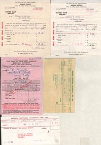 Bendigo Historical Society Inc.
Document - L. PROUT COLLECTION: WATER RATES
Seven invoices from the State Rivers and Water Supply Commission from 1960 to 1962 plus 2 receipt for payments. The invoices are in the name of Lilian M. Prout, 24 Quick Street, Bendigoorganization, public utility, water -
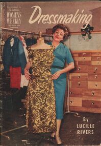 Bendigo Historical Society Inc.
Magazine - AILEEN AND JOHN ELLISON COLLECTION: DRESSMAKING
Magazine: dressmaking by Lucille Rivers, supplement to the Australian Women's weekly, not to be sold separately. On the cover a lady in blue dress standing with a mannequin displaying a gold and brown dress. The magazine has 48 pagesbooks, magazines, dressmaking -
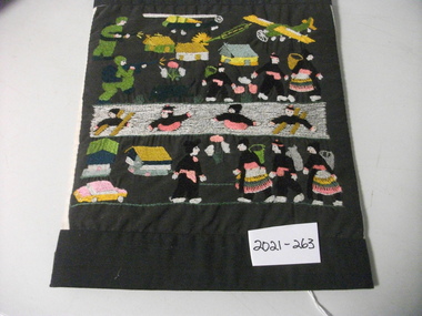 National Vietnam Veterans Museum (NVVM)
Craft - Embroidered Panel, Embroidered Material Panel
Black material mounted on cardboard depicting soldiers, aircraft, villages & villagers in motion. Middle depicting people swimming in river. Bottom is peaceful scene with figures in black with colourful dress. All embroided.Hand made panel.embroidered panel -
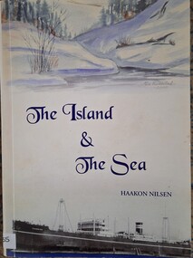 Tatura Irrigation & Wartime Camps Museum
Book, The Island and the Sea
Story written by Haakon Nilsen, an internee in Australia during WW2. Tells his story as a child, his mother, father and eventually finding other relations in America and life at sea prior to WW2.Soft cover book, with white cover. Front is divided in three. Top section depicting riverbank and river and trees; middle has title and authors name; bottom has a picture of a ship "Touraine"haakon nilsen, australian internee, touraine