Showing 10954 items matching " land"
-
 City of Moorabbin Historical Society (Operating the Box Cottage Museum)
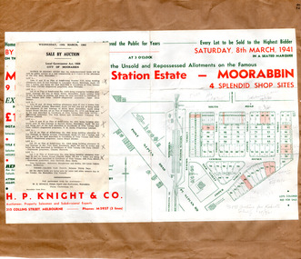
Flyer - Moorabbin Electric Station Estate, Moorabbin, 1941
The train line from the city to Frankston was electrified in 1922 which intensified the sale in the municipality of Moorabbin, particularly land which was in the vicinity of the railway stations. Moorabbin Electric Station Estate Sale of unsold and repossessed Allotments, the original sale was on Saturday 30 May 1925.Example of the progress of the Municipality of MoorabbinAdvertising flyer for auction of real estate sales - plan of building blocks for saleMoorabbin Electric Station Estate, Moorabbin. Auction Saturday 8 March 1941 - 9 villa units 4 shop sitessouth road, station street, taylor street, healey street, jasper street (now redholme street), central avenue, moorabbin, real estate -
 Victorian Interpretive Projects Inc.
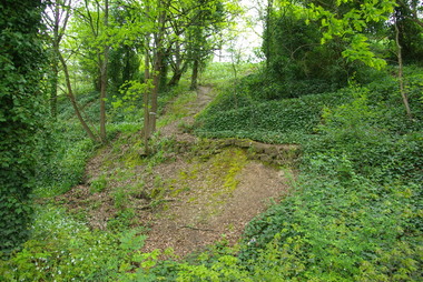
Photograph - Colour, Clare Gervasoni, Drystone wall at White Flat, Ballarat, 07/10/2012
White Flat was an early gold diggings. As early as 1856 the White Flat Drainage and Mining Co. constructed water races, drained the swampy land, and changed the course of the Yarrowee Creek. This may be remnants of that work. See http://bih.ballarat.edu.au/index.php/White_Flat_Drainage_and_Mining_Co.#cite_note-0 Five colour digital imaged of a bluestone drystone wall at White Flat, Ballarat. The drystone wall is on the steep embankment between Hickman Street and Armstrong Street South. ballarat, white flat, white flat sports ground, hickman street, south street, armstong street, oval, cricket, football, white flat drainage, yarrowee creek drystone, bluestone -
 Clunes Museum
Certificate, SWAINSON FAMILY, STATEMENT OF RECEIPTS AND EXPENDITURE
CERTIFICATE OF ESTATE FROM THE SWAINSON FAMILY HOME IN HILL STREET, CLUNES. THAT BEING SALE OF ASSET/S, LAND AND DWELLING, BEING ALLOTMENT 11, SECTION 6, TOWNSHIP OF CLUNES, PARISH OF CLUNES, COUNTY OF TALBOT. SOLD TO MRS. C.K. BUCHANAN. 1918-1919PHOTOCOPIES OF: .1 THE BALLARAT TRUSTEES EXECUTORS & AGENCY COMPANY LIMITED. STATEMENT OF RECEIPTS & EXPENDITURE FOR AND ON A/C OF ESTATE OF JOHN SWAINSON DECEASED DATED 23/9/1919 .2 & .3 PHOTOCOPIES OF THE BALLARAT TRUSTEES EXECUTORS & AGENCY COMPANY LIMITED. ESTATE OF JOHN SWAINSON DECEASED DATED 23/9/1919 .4 COVER LETTER FROM THE BALLARAT TRUSTEES EXECUTORS & AGENCY COMPANY LIMITED TO MRS. L.E. SWAINSON WIDOW OF JOHN SWAINSON DATED 17/10/1918 CHEQUE IN THE AMOUNT OF 93 POUNDS, 19 SHILLINGS AND ZERO PENCE IN LIEU OF THE SIGNED RELEASE.NILlocal history, certificates, swainson family, mrs. c k buchanan -
 Whitehorse Historical Society Inc.
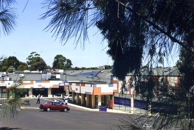
Photograph, Blackburn North Shopping Centre, 2012
Blackburn North Shopping Centre was originally known as Old Orchard Shopping Centre. It was built in 1965 on land previously covered by orchards. The name of the centre changed in the 1970's to North Blackburn Square Shopping Centre and in the 1990's to the Blackburn North Shopping CentreColoured photograph of the North Blackburn Shopping Centre, cnr. of Springfield and William Roads. The buildings are distinguished by orange, white and blue geometric shapes - 2012blackburn north shopping centre, shopping centre -
Bialik College
Plan (item) - Site development proposals, Shakespeare Grove, 1986
Site development proposals for 6 Shakespeare Grove, Hawthorn, as part of the Bialik College Strategy Plan, created by Jennings Project Management, October 1986. Includes plan of existing land use and site constraints. Please contact [email protected] to request access to this record.1980s, building and planning -
 Port Fairy Historical Society Museum and Archives
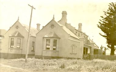
Photograph
The land for this building was granted to the Benevolent Society by James Atkinson in 1850. Tenders were being called for a new "Benevolent Asylum" in 1855, the foundation stone having been laid and by 1856 the first part of the Hospital was completed. These extensions probably carried out 1930's?????Black and white photograph of Right side of hospital new extension with bay windowshospital, institution, health service, extension, benevolent asylum, benevolent society -
 Sunbury Family History and Heritage Society Inc.
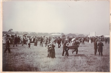
Photograph, Sunbury Racecourse
The photograph was taken at a Sunbury Race meeting, when a sudden shower of rain caused the spectators to run for cover. Sunbury Race Course was situated along Racecourse Road about 2kms from the railway station. The land has been sold and it is now a housing estate. The race meetings in Sunbury were well attended with special trains running from Melbourne on race days.A noon-digital sepia photograph mounted on cardboard of a crowd of people caught in a sudden shower of rain and running for shelter at a race meeting.sunbury race meetings, racecourse road, races, stud farms -
 Sunbury Family History and Heritage Society Inc.
Photograph, Rosa McCall, Sunbury Cultural Ring, May 2018
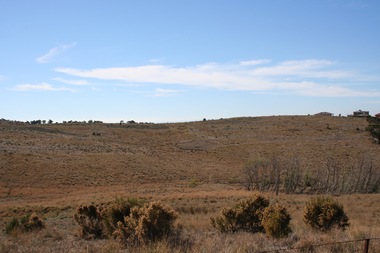
The photograph is of one of the Sunbury Cultural Rings sites. There are three Aboriginal earthen rings. The one in the foreground which is clear of weeds has been formed as a round dip in the earth and it is thought it was used as an Aboriginal gathering place. They are owned and managed by the Wurundjeri Tribe Land Council.The rings bear evidence of Aboriginal settlement and land use in the area. A coloured landscape photograph of open grassland and hills across the valley with a few native trees growing . aboriginal cultural rings, sunbury, jacksons creek, wurundjeri people -
 Ballarat and District Irish Association
Image, T. Brennan, c1864, 1864
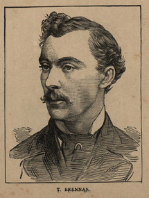
Following the founding meeting of the Mayo Tenants Defence Association in Castlebar, County Mayo on 26 October 1878 the demand for The Land of Ireland for the people of Ireland was reported in the Connaught Telegraph 2 November 1878. The first of many "monster meetings" of tenant farmers was held in Irishtown near Claremorris on 20 April 1879, with an estimated turnout of 15,000 to 20,000 people. This meeting was addressed by James Daly (who presided), John O'Connor Power, John Ferguson, Thomas Brennan, and J. J. Louden. The Connaught Telegraph's report of the meeting in its edition of 26 April 1879 began: Since the days of O'Connell a larger public demonstration has not been witnessed than that of Sunday last. About 1 o'clock the monster procession started from Claremorris, headed by several thousand men on foot – the men of each district wearing a laural leaf or green ribbon in hat or coat to distinguish the several contingents. At 11 o'clock a monster contingent of tenant-farmers on horseback drew up in front of Hughes's hotel, showing discipline and order that a cavalry regiment might feel proud of. They were led on in sections, each having a marshal who kept his troops well in hand. Messrs. P.W. Nally, J.W. Nally, H. French, and M. Griffin, wearing green and gold sashes, led on their different sections, who rode two deep, occupying, at least, over an Irish mile of the road. Next followed a train of carriages, brakes, cares, etc. led on by Mr. Martin Hughes, the spirited hotel proprietor, driving a pair of rare black ponies to a phæton, taking Messrs. J.J. Louden and J. Daly. Next came Messrs. O'Connor, J. Ferguson, and Thomas Brennan in a covered carriage, followed by at least 500 vehicles from the neighbouring towns. On passing through Ballindine the sight was truly imposing, the endless train directing its course to Irishtown – a neat little hamlet on the boundaries of Mayo, Roscommon, and Galway. Evolving out of this a number of local land league organisations were set up to work against the excessive rents being demanded by landlords all over Ireland, but especially in Mayo and surrounding counties. From 1874 agricultural prices in Europe had dropped, followed by some bad harvests due to wet weather during the Long Depression. The effect by 1878 was that many Irish farmers were unable to pay the rents that they had agreed, particularly in the poorer and wetter parts of Connacht. The localised 1879 Famine added to the misery. Unlike other parts of Europe the Irish land tenure system was inflexible in times of hardship. (Wikipedia) The Irish National Land League was founded at the Imperial Hotel in Castlebar, the County town of Mayo, on 21 October 1879. At that meeting Charles Stewart Parnell was elected president of the league. Andrew Kettle, Michael Davitt, and Thomas Brennan were appointed as honorary secretaries. This united practically all the different strands of land agitation and tenant rights movements under a single organisation. Michael Davitt Founder of the Land League The two aims of the Land League, as stated in the resolutions adopted in the meeting, were: ...first, to bring out a reduction of rack-rents; second, to facilitate the obtaining of the ownership of the soil by the occupiers. That the object of the League can be best attained by promoting organisation among the tenant-farmers; by defending those who may be threatened with eviction for refusing to pay unjust rents; by facilitating the working of the Bright clauses of the Irish Land Act during the winter; and by obtaining such reforms in the laws relating to land as will enable every tenant to become owner of his holding by paying a fair rent for a limited number of years. (Wikipedia)Image of a man with a moustache. He is T. Brennan.ballarat irish, brennan, thomas brennan, irish land act, rent -
 The Beechworth Burke Museum
Photograph, 1865
This image was taken in 1865 overlooking the diggings at Spring Creek, Beechworth. Gold was discovered in this area in 1852 and within eleven months of this discovery, over 8000 hopeful prospectors had descended on the region, transforming the seemingly undisturbed land into what a visiting journalist in 1880s referred to as; "A Titan's Field". Huge mounds of earth were churned by hundreds of miners in search for gold, almost every available resource the land had to offer was used for something; even the bark off the gums were stripped to line huts and shafts. By 1857 more than 20,000 people lived in Beechworth, and with this influx the town prospered with the building of numerous churches, banks, schools, shops and hotels along with a prison and hospital.Black and white rectangular photograph. Image is printed on matte photographic paper and is mounted on cardboard. Obverse: NO INSCRIPTION Reverse: 7771 / BEECHWORTH / FROM SPRING CREEK / 1865 spring creek, diggings, beechworth, 1865 -
 The Beechworth Burke Museum
Photograph, 1865
This image was taken of the diggings at Spring Creek. In February 1852 gold was discovered at Spring Creek, Beechworth. Within eleven months of this discovery, over 8000 hopeful prospectors had descended on the region, transforming the seemingly undisturbed land into what a visiting journalist in 1880s referred to as; "A Titan's Field". Huge mounds of earth were churned by hundreds of miners in search for gold, almost every available resource the land had to offer was used for something; even the bark off the gums were stripped to line huts and shafts. By 1857 more than 20,000 people lived in Beechworth, and with this influx the town prospered with the building of numerous churches, banks, schools, shops and hotels along with a prison and hospital.Black and white rectangular photograph. Image is printed on matte photographic paper and is mounted on cardboard. Obverse: NO INSCRIPTION Reverse: BMM6926 / BEECHWORTH FROM SPRING CREEK 1865 spring creek, beechworth, burke museum, 1865, gold rush -
 Eltham District Historical Society Inc
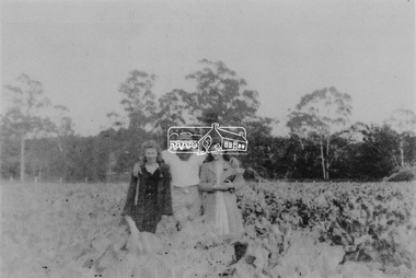
Photograph, From left: Unknown, Mario Fabbro and possibly Helen Skipper, Bell Street, Eltham
At Bell Street, Fabbro Farm, Eltham; From left: Unknown, Mario Fabbro and possibly Helen Skipper, standing in the middle of a vegetable crop. The site of the Fabbro farm (Diamond Creek side land) is now called Barrack Bushlands. It is doubtful that Fabbro's farm holding was ever called Barrak Park, This title is fairly recent after the Shire of Eltham purchased the land, including the last section in 1993/94. About this time the area on the west side of Falkiner Street was purchased by a private developer and developed as housing. The area in Bell Street opposite the Eltham High School was purchased by the State Government is recent years and is called Fabbro Fields. The Fabbro Family operated their farm in Bell Street, Eltham. 1 black and white photographfabbro's farm, bell street, eltham, maurice fabbro, farming, helen skipper, vegetables -
 Eltham District Historical Society Inc
Photograph, Fabbro's farm, Bell Street, Eltham, c.1990s
Fabbro's farm and house, Bell Street, Eltham, c.1990s. A crop of artichokes were planted on the farm at this time. The site of the Fabbro farm (Diamond Creek side land) is now called Barrack Bushlands. It is doubtful that Fabbro's farm holding was ever called Barrak Park, This title is fairly recent after the Shire of Eltham purchased the land, including the last section in 1993/94. About this time the area on the west side of Falkiner Street was purchased by a private developer and developed as housing. The area in Bell Street opposite the Eltham High School was purchased by the State Government is recent years and is called Fabbro Fields. The Fabbro Family operated their farm in Bell Street, Eltham. 1 colour photograph printed with white borderfabbro's farm, bell street, eltham, artichokes, barak farm -
 Eltham District Historical Society Inc
Photograph, Artichokes growing at Bell Street, Eltham, c.1990s
Fabbro's farm and house, Bell Street, Eltham, c.1990s. A crop of artichokes were planted on the farm at this time. The site of the Fabbro farm (Diamond Creek side land) is now called Barrack Bushlands. It is doubtful that Fabbro's farm holding was ever called Barrak Park, This title is fairly recent after the Shire of Eltham purchased the land, including the last section in 1993/94. About this time the area on the west side of Falkiner Street was purchased by a private developer and developed as housing. The area in Bell Street opposite the Eltham High School was purchased by the State Government is recent years and is called Fabbro Fields. The Fabbro Family operated their farm in Bell Street, Eltham. 1 colour photograph printed with white borderfabbro's farm, bell street, eltham, artichokes, barak farm -
 Eltham District Historical Society Inc
Photograph, Maurice Fabbro with artichokes growing at Bell Street, Eltham, c.1990s. Maurie is in his 70s
Fabbro's farm and house, Bell Street, Eltham, c.1990s. A crop of artichokes were planted on the farm at this time. The site of the Fabbro farm (Diamond Creek side land) is now called Barrack Bushlands. It is doubtful that Fabbro's farm holding was ever called Barrak Park, This title is fairly recent after the Shire of Eltham purchased the land, including the last section in 1993/94. About this time the area on the west side of Falkiner Street was purchased by a private developer and developed as housing. The area in Bell Street opposite the Eltham High School was purchased by the State Government is recent years and is called Fabbro Fields. The Fabbro Family operated their farm in Bell Street, Eltham. 1 colour photograph printed with white borderfabbro's farm, bell street, eltham, artichokes, barak farm, maurice fabbro -
 Kew Historical Society Inc
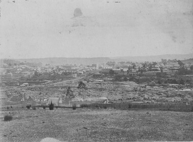
Photograph - Studley Park, 1937
Those sections of Studley Park closest to the River Yarra were set aside as parkland in the 1850s. After initial discussions about whether it was a suitable site for a Government House, much of the land was instead gazetted in the 1860s as the location for a new lunatic asylum, to expand overcrowded mental health facilities at the Yarra Bend Asylum on the other side of the river at Fairfield. Those sections of Studley Park bounded by the Yarra River, Studley Park Road, Princess Street and Fellows Street were subdivided and sold at the Crown Land Sales in 1851. Much of this urban area remained open farmland until the twentieth century, apart from mansions, largely located along the main roads.Original, black and white positive print of what is said to represent Studley Park in 1937. If the attribution and date is literally to be understood, then it would appear that the photograph may have been taken from the Kew side of the river looking across to open farmland in the Yarra Bend Park. If the designation of Studley Park is to be understood more loosely, then it might be a view of what is now East Kew, taken from a section of Kilby Road. Inscribed verso: "Studley Park 1937" studley park -- kew (vic.) -
 The Beechworth Burke Museum Research Collection
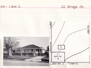
Card (Series) - Index Card, George Tibbits, 22 Bridge Street, Beechworth, 1976
George Tibbits, University of Melbourne. Faculty of Architecture, Building and Town & Regional PlanningIndex system that support the research for Beechworth : historical reconstruction / [by] George Tibbits ... [et al]Arranged by street names of BeechworthEach index card includes: street name and number of property, image of property, allotment and section number, property owners and dates of ownership, description of the property according to rate records, property floor plan with dimensions.beechworth, george tibbitsbeechworth, george tibbits -
 Wooragee Landcare Group
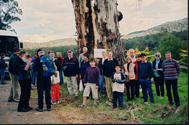
Photograph, 5 Sepember 2004
This photograph was taken at Riverview Farm, Victoria on Sunday the 5th of September as part of a day trip by the Wooragee Landcare Group. The event was about looking at land use on small farms and as a social get-together for the Group. Wooragee was also researching how small landholders could run some enterprises around the time of the trip. This photograph includes Julius Holt, Graeme Missen, Peter and Lesley Finedon, Sue Brunskill, Jacky Luisi, Bonnie Payne, Bob and Christine Stewart, Oliver Payne, and Gerri Boland. Wooragee Landcare Group was created in 1988. Its core mission is to work towards eradicating animals and pests from the land to protect the natural vegetation and promote revegetation projects.This photograph is a great example of the type of events that Wooragee Landcare Group has organized, while educating the public about the importance of land use management.Reverse: WAN NA E0NA2N2. NN1- 3 4556 / [PRINTED] (No. 9) / 188wooragee, wooragee landcare group, wooragee landcare's collection, land use, social, riverview farm, animals, pests -
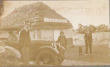 Phillip Island and District Historical Society Inc.
Photographs, 1926
Part of a collection of photographs out of an old photo album with multiple photos on each page. Donated by Margaret Webster. Margaret's parents were Sir Charles & Lady McGrath who lived near the RSL in Ventnor Road, Cowes.286-18 - Sepia photograph of The Tea Room at Shelly Beach, Phillip Island or San Remo?. Two men, a lady and dog beside two cars. One car has a woman inside. 286-19 - Sepia photograph of a group of 13 people in coastal scrub land at Shelly Beach. 286-20 - Sepia photograph of a group of 13 people in coastal scrub land at Shelly Beach. 286-21 - Sepia photograph of a group of people having a picnic in front of the San Remo Hotel. 286-22 - Sepia photograph of 3 people at The Nobbies, Phillip Island. 286-23 - Sepia photograph of rough seas at The Nobbies, Phillip Island. 286-24 - Sepia photograph of a man with a young penguin possibly at Slummerlands Phillip Island. 286-25 - Sepia photograph of breakers at The Nobbies, Phillip Island. 286-26 - Sepia photograph of The Continental Guesthouse with guests on the verandah. 286-27 - Sepia photograph of an unmade road with scrub vegetation on the sides. 286-28 - Sepia photograph of Cowes foreshore with the Jetty in the background. 286-29 - Sepia photograph of the Cowes Jetty with people arriving off a ferry. 286-30 - Sepia photograph of Cowes foreshore with the Jetty in the background and a ferry.286-18 - "The Teahouse - Shelly Beach" 286-19 - "A Confidential Chat - Shelly Beach" 286-20 - "The Wanders - San Remo" 286-21 - "Lunch at San Remo" 286-22 - "The Nobbies - P.I." 286-23 - "Rough Seas - The Nobbies" 286-24 - "A Young Penguin" 286-25 - "Breakers - The Nobbies" 286-26 - "The Contin - Cowes" 286-27 - "The Road to the Back Beach" 286-28, 29 & 30 - "Beach and Jetty at Cowes"the nobbies phillip island, young penguins, wildlife - penguins, tea house behind shelly beach, shelly beach, san remo hotel, the continental guesthouse, the continental hotel, cowes jetty, margaret webster -
 Bendigo Historical Society Inc.
Document - CONNELLY, TATCHELL, DUNLOP COLLECTION: LEGAL DOCUMENTS, 1919 & 1920
Documents. Various legal documents. 1 - 1920 - Sloan John Esq (Bul-A-Bul) Re costs owed Federal Land Tax. 2 - 1920 - Scholten G J. deceased (::Bendigo) RE costs Income Tax. 3 - 1919 - Connell J D & Bailey A D (clo Mr F Lapsley Bendigo) re costs Bogie. 4 - 1920 - Chambers John Jr. (Leichardt) re costs Chambers. 5 - 1920 - Cowling W (Bendigo) re costs Burke. 6 - 1919 - 1920 - Bailey A W Farmer (South Calivil) re costs Mathoura Land and Will. 7 - 1919 - 1920 - Bell Albert J (Leichardt) re costs A D A insurance and Will. 8 - 1919 - Bell S (Chemist Inglewood) re costs Libel. 9 - 1920 - Bagnell L Sr (Mologa) re costs Income Tax Returns. 10 - 1920 Bell James & Co. (:Melbourne) re costs Hogan. 11 - 1919 Butcher W H (Raywood) re costs Shadbolt, McNamara. 12 - 1920 - Bell John (Farmer Leichardt) re costs you from Cocks. Additional names:- McNamara, Bell John, Cocks.cottage, miners, connelly, tatchell & dunlop, sloan john, scholten g j, connell j d, bailey a d, lapsley mr f, bogie, chambers john jr, cowling w, burke, bailey a w, bell albert j, a d a insurance, bell a, bagnell l sr, bell james & co, hogan, butcher w h, shadbolt -
 Kew Historical Society Inc
Plan, Melbourne & Metropolitan Board of Works : Contour Plan of Melbourne & Suburbs : Melbourne Sewage, 1894
The Melbourne and Metropolitan Board of Works (MMBW) plans were produced from the 1890s to the 1950s. They were crucial to the design and development of Melbourne's sewerage and drainage system. This plan forms part of a large group of MMBW plans and maps that was donated to the Society by the Mr Poulter, City Engineer of the City of Kew in 1989. Within this collection, thirty-five hand-coloured plans, backed with linen, are of statewide significance as they include annotations that provide details of construction materials used in buildings in the first decade of the 20th century as well as additional information about land ownership and usage. The copies in the Public Record Office Victoria and the State Library of Victoria are monochrome versions which do not denote building materials so that the maps in this collection are invaluable and unique tools for researchers and heritage consultants. A number of the plans are not held in the collection of the State Library of Victoria so they have the additional attribute of rarity.Digital copy of an original MMBW plan. This contour plan shows the area identified by the MMBW for purposes of drainage and sewerage in 1894. The suburbs represented extend from Williamstown in the west to Bulleen in the east, and from Preston in the north, south to Sandringham. Suburbs are outlined in coloured ink. Red lines indicate main and branch sewers in existence at the beginning of 1894 in central and inner Melbourne. These extended as far as Williamstown and Brighton, but not yet as far as Kew, where sewering did not commence until 1901. Contour lines show the topography, which was important for indicating the fall of the land for the laying of sewers and drainage channels. Kew appears to be fairly undeveloped at this date except for railway lines and stations (the Kew and Outer Circle lines), main roads, the Kew Lunatic Asylum Reserve and Studley Park. However, the contour plan does not accurately represent the density of settlement, nor the large number of houses, which were being built in Kew and other suburbs from the 1850s to the land boom of the late 1880’s and early 1890’s. This plan is part of a large and historically significant group of MMBW plans and maps that was donated to the Society by the Mr Poulter, City Engineer of the City of Kew in 1989.mmbw contour plan of melbourne and suburbs, melbourne and metropolitan board of works, melbourne sewage, cartography -
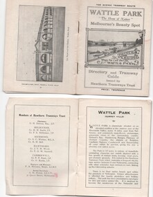 Melbourne Tram Museum
Ephemera - Timetable, Hawthorn Tramways Trust (HTT), "Directory and Tramway Guide issued by the Hawthorn Tramways Trust", 1918
Booklet - 38 pages, printed on off white page, centre stapled, titled "Directory and Tramway Guide issued by the Hawthorn Tramways Trust", specifically advertising Wattle Park and showing Princes Bridge and the Yarra on the front cover and a photo of Hawthorn depot on the rear cover. Gives details of Wattle Park, its opening, many photos, members of the Trust, Engineer and Manager and Acting Secretary, Stopping points for the round and fares to Wattle Park, section fares, maps of the tram routes and connections with other tramways and railway stations. Has timetables for Burnley and other major points, special and emergency services, the coloured lights used on the trams, and a map for land sales at Riversdale Heights estate. Advertisements for Mutual stores, Melbourne Electric Supply Co., Moule, Hamilton and Kindle for the sale of land at Riversdale Heights and a map showing the estate location. Both copies have alterations or corrections to the route signage letters - marked in red - from the Minutes of the HTT Board meetings, the Trust were not happy with the finished product and was reluctant to pay for them - see Minutes of Meeting No. 99 of 5-7-1918. Two copies held - one with red marks on the front cover.trams, tramways, htt, wattle park, princes bridge, hawthorn depot, timetables, mesco, real estate -
 Bendigo Historical Society Inc.
Document - MCCOLL, RANKIN AND STANISTREET COLLECTION: INDENTURE BETWEEN KING EDWARD VIII AND MONUMENT HILL CONSOLIDATED MINE, 2/09/1936
Indenture document number 10878, Vol 317 Folio 35044. Foolscap 4 pages including a map, dated 2nd September, 1936, between King Edward VIII (Crown land) and Monument Hill Consolidated (Bendigo) No Liability 'carrying on operations in the Parish of Sandhurst, to occupy and use the land demised as a site for machinery buildings and offices to be used in connexion with 'mining purposes' ' Document signed by Right Hon William Charles Arcedeckne, (Baron Huntingfield) and J. Stanistreet, Manager, affixed with the Common Seal of Monument Hill Consolidated (Bendigo) No Liability. Map drawn on dark buff paper, and fixed to document. Map shows lease 10878 in the Mining District of Bendigo, Parish of Sandhurst, County of Bendigo. N.Area 2.2.24 ( 2 acres, 2 roods, 24 perches ) Lease site on Rowan Street, bordered by Ophir Street. Coloured in purple on plan with small red area. On bottom: ' Note Red Areas Excised. Scale 4 chains to 1 inch, M.M. Var. 8 degrees 32' E. On lease site, New Chum Gully marked, W.B. House, and Permanent Occy. marked on red area. On last page ownership of lease details from 1937 to 1942.bendigo, mining, monument hill consolidated, common seal of monument hill consolidated, nell gwynne mine, south nell gwynne gold mining company, bendigo mine, ophir street, rowan street, mackenzie street.indenture vol 317 fol. 35044. j stanistreet. -
 Kew Historical Society Inc
Document - Urban Planning Document, City of Kew, City of Kew : Minimum Size of Allotment Required, 1945-1955
A document outlining the relevant by-laws produced by the City Of Kew to regulate the minimum size of allotments in Barkers Road, Burke Road, Cotham Road, Glenferrie Road and Studley Park Road, as well as in other streets more generally. The by-laws specify the size of allotments in which single unit dwellings, attached houses and maisonettes, and flats could be built. In the ‘main streets’ a minimum land area for single unit dwellings was 8,100 square feet, with an average frontage of 60’ and a depth of 135’. In other streets this was reduced to an overall size of 6,250 square feet, with an average dimensions of 50’ x 125’. In specifying the land area required by flats, different sizes were regulated for the construction of between two and six flats. Six flats at the time when the regulations were passed must have been the upper limit permitted. Understanding the size of land listed in imperial measurements can be a challenge. Within Australia, the so-called quarter acre block was approximately 11,000 square feet. Those specified in the by-laws would appear to be smaller. The document was pasted on the reverse of a subdivision plan in the collection.This is a rare (undated) document produced by the City of Kew defining how subdivision within the municipality should occur. The document was created to constrain unbridled speculation in subdivisions in the various parts of Kew and East Kew.Undated typed document, issued by the City of Kew (1921-1994) indicating the minimum size of allotment required in Barkers Road, Burke Road, Cotham Road, Glenferrie Road and Studley Park Road. The document is mounted on board and waterstained. It was presumably used by a real estate agent. [Formerly catalogued as MAP.0066].city of kew - by-laws and regulations, subdivisions - kew - studley park -
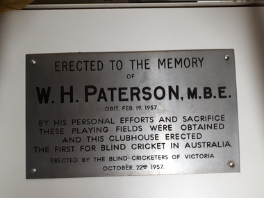 Vision Australia
Photograph - Image, W.H. Paterson - Blind Cricketers of Australia, 1957
When the Victorian Blind Cricket Association approached Mr Paterson for assistance in gaining access to a permanent cricket pitch upon which games could be played, it set in chain a series of events that remain in place today. Mr Paterson had been heavily involved in the formation of the Association for the Blind and saw this as a problem to be solved. Raising money through public donation and door knocking, Mr Paterson arranged the purchase of land on the banks of Gardiner's Creek, and adjacent to the tram and train lines. The land was raised, to avoid flooding, and a surface prepared. The sportsground was adjacent to the AAB, however due to the interest of Malvern Council in the land and knowing that the AAB at that time was in financial difficulties, a Trust was set up to handle the management with Mr Paterson, Mr Gould the Malvern Council Town Clerk and George Maxwell as trustees. A clubhouse was also needed to allow players to take shelter during matches and once again, Mr Paterson came to the rescue. Using their personal funds, Mr and Mrs Paterson loaned the Trust the monies required for the building. This plaque recognises the dedication and support that Mr Paterson gave to help establish the first blind cricket playing ground in Australia.Digital image of metal plaqueErected to the Memory of W.H. Paterson, M.B.E. Obit. Feb. 19 1957 By his personal efforts and sacrifice these playing fields were obtained and this clubhouse erected The first for blind cricket in Australia Erected by the Blind Cricketers of Victoria October 22nd 1957william paterson, victorian blind cricket association -
 Orbost & District Historical Society
calf yoke, 1920's
This calf yoke is a wooden beam used between a pair of calves to enable them to pull together on a load when working in pairs. This item was made for John Mundy as a child. The original Mundy family moved to a land "selection" at Betebolong in the early 1880's from Buchan. This is an example of a hand-made item commonly used in Orbost on dairy farms in the first half of 20th century.A hand-made wooden yoke painted brown. It has two iron neck pieces and a piece of chain attached in the centre. There are two different locking devices for the necks.calf-yoke rural -
Eltham District Historical Society Inc
Document - Folder, Phillips, Dr
Dr Phillips had land on Aitken's Creek, near Arthur's Creek by the Greensborough Road where gold had been found in 1864. Contents Photocopies: Victorian Parliamentary Papers, 1864-1865, Vol, 3, No. 22, "Reports of Collectors of Agricultural Statistics", pp95-96.Newspaper clippings, A4 photocopies, etcdr phillips, greensborough road, kangaroo ground, tarrawarra, arthur's creek, county of evelyn, warrandyte -
Eltham District Historical Society Inc
Document - Folder, Porter, John
John Porter owned land at the junction of the Plenty and Yarra Rivers, leased to Thomas Mundy. Contents Photocopies: Victorian Parliamentary Papers, 1864-1865, Vol, 3, No. 22, "Reports of Collectors of Agricultural Statistics", pp95-96. Handwritten notes: On George Porter, John Alfrey, Newspaper clippings, A4 photocopies, etcjohn porter, plenty river, yarra river, thomas mundy'henry stooks, john brown, diamons creek, aitken's creek, evelyn county, george porter, john alfrey -
 Eltham District Historical Society Inc
Document - Folder, Request for change of boundary, 1870
Document dated December 13 1870 re the change of boundary between the Greensborough Road Board and the Eltham Road Boards severance of land East of the Diamond Creek boundary. Photocopy from Letters collection, Shire of Eltham. Folder 81 from Harry Gilham Collection 3 pageswingrove, herbert, alexander donaldson, john stevenson, roads