Showing 10832 items
matching maps
-
 Creswick Campus Historical Collection - University of Melbourne
Equipment
This is a six drawer horizontal map cabinet.Equipment -
Clunes Museum
Plan - PLAN/MAP, SOUTH CLUNES GOLD MINE
PLAN AND MAP OF SOUTH CLUNES GOLDMINEPLAN OF SOUTH CLUNES UNITED G.M.CO.CLUNES PRODUCED OR DRAWN BY F.W.NIVEN & CO LITH BALLARATlocal history, document, mining, plans -
Stawell Historical Society Inc
Archive, Great Western Cemetery Records. Names of Burials Recorded, 1860
Death Certificates Inquests Register MapPhotocopied Lots of Burials at Great Western cemetery -
 Warrnambool and District Historical Society Inc.
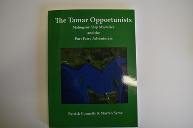
Book, The Tamar Opportunists - Mahogany Ship Mysteries and the Port Fairy Adventurers, 2022
Port Fairy Early HistoryThis is a book of 122 pages. The cover is green with a green and blue map on the front and white printing on the front and back. It contains a Foreword and Acknowledgements, an Epilogue, Appendices, Bibliography, Index and printed material, maps, sketches, tables and black and white photographs.non-fictionPort Fairy Early Historyport fairy history -
Glenelg Shire Council Cultural Collection
Map - Fold-out Tourist Map of Portland and District, n.d
Black and white fold-out map of Portland District. reverse has maps of Portland and Mt. Gambier, plus tourist information about points of interest in both towns. When folded, photo of Cape Nelson lighthouse on front. -
Bendigo Historical Society Inc.
Map - NEILBOROUGH : COUNTY OF BENDIGO, 13-10-27
Map. Neilborough, County of Bendigo, Tandarra, Whirrakee, Huntly, Nerring, Yarraberb, Yallook, Photo-Lithographed at the Department of Lands and Survey, Melbourne by W.J. Butson 13-10-27, Price 1/- (number 77 in map cupboard 1)W.J. Butson.map, bendigo, neilborough -
Bendigo Historical Society Inc.
Map - MANDURANG : COUNTY OF BENDIGO, 1962
Map. Mandurang, County of Bendigo. Sandhurst, Strathfieldsaye, Sedgwick, Lockwood. By authority A.C. Brooks, Government Printer, Melbourne. Drawn and Reproduced at the Department of Lands and Survey, Melbourne, 1962, Price 2/-. (number 67 in map cupboard 1)A.C. Brooks, Government Printer, Melbourne.map, bendigo, mandurang -
Bendigo Historical Society Inc.
Map - TALAMBE : COUNTY OF BENDIGO, 21-3-27
Map. Talambe, County of Bendigo, Hayanmi, Calivil, Pompapiel, Yallook, Tandarra, Dingee. Photo-Lithographed at the Department of Lands and Survey, Melbourne, by W.J. Butson 21-3-27, Price 2/-. (number 27 in map cupboard 1)W.J. Butsonmap, bendigo, talambe -
Bendigo Historical Society Inc.
Map - EPPALOCK : COUNTY OF BENDIGO, 2-11-14
Map. Eppalock, County of Bendigo,Lyell, Sedgwick, Strathfieldsaye, Axedale, Knowsley, Kimbolton. Photo-Lithographed at the Department of Lands and Survey, Melbourne by W.J. Butson, 2-11-14. Price 1/-. (number 39 in map cupboard 1)W.J. Butson.map, bendigo, eppalock -
Bendigo Historical Society Inc.
Map - YARRAYNE : COUNTY OF BENDIGO, 6-1-32
Map. Yarrayne, County of Bendigo, Janiember East; Pompapiel, Salisbury, Bridgewater, Salisbury West, Powlett. Photo-Lithographed at the Department of Lands and Survey, Melbourne. Price 2/-. 6-1-32. (number 12 in map cupboard 1)H.J. Green, Government Printermap, bendigo, yarrayne -
Bendigo Historical Society Inc.
Map - PANNOOMILLOO : COUNTY OF BENDIGO, 1957
Map. Pannoomilloo, County of Bendigo, Milloo, Warragamba, Diggorra, Pannoobamawm. Drawn and reproduced at the Department of Lands and Survey, Melbourne,1957. Price 2/-. By Appointment W.M. Houston, Government Printer, Melbourne. (number 3 in map cupboard 1)W.M. Houston, Government Printermap, bendigo, pannoomilloo -
Bendigo Historical Society Inc.
Map - STRATHFIELDSAYE, See above
Map: Township of Strathfieldsaye, Group of 4 plans, 2 hand drafted and 2 printed. Applied to canvas and stapled to the backing. The printed plans are dated January 1859 and 6th January 1871 (number 267 in map cupboard 1)map, bendigo, township, strathfieldsaye -
 National Vietnam Veterans Museum (NVVM)
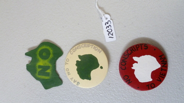
Functional Object, Protest badges
Three plastic protest badges. 1 - Red round badge with map of Australia and words "no conscripts to Vietnam" 2 - Cream round badge with map of Australia and words "Say no to 3 conscription" 3 - Green outline of Australia with word "NO"As describedbadges, conscription -
Bendigo Historical Society Inc.
Map - WANURP: COUNTY OF BENDIGO, 1/12/33
Map. Wanurp, County of Bendigo, Terrick Terrick East, Mitiamo, Dingee, Milloo, Pannoobamawm. L422+. Photo-Lithographed at the Department of Lands and Survey, Melbourne, Price 2/-. 1/12/33 ( number 411 in Map Cupboard 1 )H.J. Green, Government Printerbendigo, hospital -
Moorabbin Air Museum
Map (Item) - AAF Cloth Map- Southwest Pacific Area: Nos. 22,25 & 26
-
 Warrnambool and District Historical Society Inc.
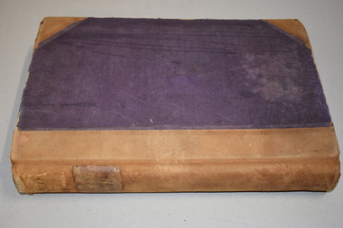
Letter book 13, 1920
This letter book contains letters, sketch maps and plans and dates from 1920 to 1923. It came from the office of John William Crawley Junior, an engineer, architect and surveyor in private practice in Warrnambool and also the engineer for the Shire of Warrnambool from 1895 to 1935. His father, brother and son were also engineers and worked in that capacity or as the Shire Secretary for the Shire of Warrnambool, with the Crawley family recording a total of 132 years of service to the Shire. The letter book was passed onto John Crawley’s son, Rolf, the engineer for the Shire of Warrnambool from 1935 to 1968. It then came into the possession of Michael Hand who took over the private surveying business on Rolf Crawley in Warrnambool. The Warrnambool and District Historical Society acquired the letter book, along with several other Crawley ledgers, from the estate of Michael Hand. This letter book is of considerable significance as it contains letters and maps drawn up by John William Crawley, an engineer in the Shire of Warrnambool for 40 years. It will be very useful for researchers.This is a dark red hard- cover letter book of 1001 pages. The book has brown binding on the corners of the cover and on the spine. There is gold lettering on the spine. The inside of the cover is lined with a multi-coloured mottled pattern. The cover is stained and scuffed. The pages contain handwritten letters, sketch maps and plans and an alphabetical index at the front. There are three loose pages. There is a mauve stamp on the first page.‘Letter Book 1920 to 1923’ ‘Rolf. L. Crawley Civil Engineer, Drainage and Water Supply Engineer, Licensed Surveyor, Registered Architect, Warrnambool’ john william crawley junior, warrnambool, rolf crawley, warrnambool, shire of warrnambool -
 Vision Australia
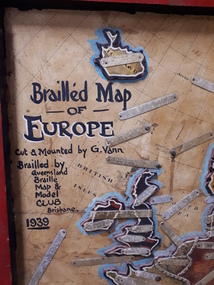
Map - Object, Brailled Map of Europe, 1939
This tactile map of Europe was created in 1939, and brailled by the Queensland Braille Map and Model Club. Cut and mounted by G. Vann with geographical inforamtion provided by Miss E Southern. The Queensland Braille Map and Model Club was a volunteer organisation which produced tactile maps from the 1920s to the late 1940s. These were sent as presents to schools, organisations and missions for people who were blind or vision impaired around Australia, New Zealand, Syria, India, Canada, Papua New Guinea and Africa. Due to free postage of Braille obtained by Tilly Aston and her compatriots, the maps were transported gratis within Australia and at a cheap rate overseas. When this map was made, East Prussia, Danzig and the Levant States were all separate countries. Some information about each country (name, area in sq miles and population) is written on a small door on the right hand side, which can be opened to reveal the same information in Braille. At the base is a braille and handwritten note "Information about maps gratis from Miss E Southern "Kingsley" George St, Brisbane. "For lending to the Blind" is written at the base of the wooden frame.1 paper attached to wooden mount with metal labels, on the right hand side a small door with country information on the front and opens to reveal the same in Braille. queensland braille map and model club, r.f. tunley -
 Bendigo Military Museum
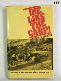
Book, Harry Gordon, Die like the Carp!, c.1978
Folded page inside front of book. One side has a map of Cowra,New South Wales, the other has a map & information about the Japanese Garden & Cultural Centre, Cowra, New South Wales.Book, 240 pages, orange hard cover with yellow & black dust jacket. Front of dust jacket has photo of the body of a soldier lying on the ground & the back a photo of 2 men & 1 woman looking at photos. Written on 1st page: Nancy Brown Written on back of 2nd page: Alan W Brown Written on title page: Donated by Bgo Y Mens Clubbooks, military, history -
Federation University Historical Collection
Map, Town of Buninyong, 1927, 09/1927
The date of this map is September 1927 revised from the original 1910 map. Buninyong was created a district on 09 July 1858, proclaimed a Shire on 16 February 1864, and the Buninyong Borough united on 01 October 1915.Township plan of the Town of Buninyong showing government roads and crown allotments. Earlier detail pencilled on (commercial buildings, etc) appears to be from an 1850 survey. Scale: 4 chains to 1 inch (1:3168)buninyong, map, buninyong botanical gardens, tannery dam, buninyong reservoir, chapel school, rev. hastie -
 Warrnambool and District Historical Society Inc.
Documents, Late 20th, early 21st centuries
These ten documents (maps, plans, photographs) mostly come from the Warrnambool City Council and most contain information on sub-divisions and titles of properties in areas around the Central Business District of Warrnambool. The dates range from 1986 to 2006. These maps, plans and photographs are of some interest as they give historical details of subdivisions in Warrnambool and date from the late 20th century. .1 This is a laminated map of the boundaries of Local Governments in Victoria. It is Sheet I of 2 and has red and blue pencil markings and black boundary markings. .2 This is a copy of a plan of a survey in black and white markings on paper. .3 This is a plan of the title details of Section 19 Warrnambool. It has black printing on buff-coloured paper. .4 This is a plan of the allotments in part of the Central Business District of Warrnambool. It is printed in black and white. .5 This is a 2006 coloured aerial photograph of the harbour at Warrnambool – Breakwater etc. .6 This is a 2006 coloured aerial photograph of the Lake Pertobe area in Warrnambool .7 This is a coloured aerial photograph of Warrnambool’s streets over-stamped with road numbers in large blockings. .8 This is a plan showing the title details of Section 11 in Warrnambool. It has black printing on buff-coloured paper. .9.1 This is a plan of sub-divisions in parts of Crown Allotments 38 & 39 in Warrnambool. It has green, pink and yellow markings with black printing. .9.2 This is a plan of the sub-divisions in parts of Allotments 38 & 39 in Warrnambool. It has pink, yellow and blue markings with black printing. It is somewhat faded. warrnambool c.b.d. maps and plans, history of warrnambool -
 Glen Eira City Council History and Heritage Collection
Map - Map, zoning, Metropolitan Town Planning Commission, "DISTRIBUTION AND USE OF EXISTING PROPERTY. MAP NO. 6.", 1929
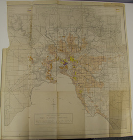
The map titled: “Distribution and use of Existing property map No. 6” (Metropolitan Town Planning Commission Melbourne and Suburbs) is of historical significance. It is listed on page 168 of Chapter 4 the Zoning section of the "Plan of General Development Melbourne Report of the Metropolitan Town Planning Commission 1929" - Melbourne's first strategic plan. Map No. 6 is mentioned throughout Chapter 4 of the 1929 Report. It states on page 156 that this Map was created to graphically illustrate the data collected by the Planning Commission. The Map illustrates the general distribution of uses of existing property throughout the metropolitan area. The coloured sections show the areas which were developed or were in the process of development in 1929. The colours indicate the distribution of uses in the developed areas. The pink coloured areas, which include Caulfield, were almost completely residential.1929, metropolitan town planning commission, melbourne, suburbs -
 Eltham District Historical Society Inc
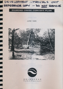
Book, Melbourne Parks & Waterways, Diamond Creek Concept Plan, June 1995
-
 Bendigo Military Museum
Book - Sun Observations for Azimuth - Astronomical Fixations Woomera 1951, 28.05.1951 to 02.08.1952
Field Survey control position fixing observations for the Woomera Rocket Range, South Australia. Sun Astronomical observations by Sergeant NRJ Hillier later Colonel and Director of Military Survey-Army, and Sergeant DR Ridge later Lieutenant Colonel and Commanding Officer of the Army Survey Regiment.Hard covered book, handwritten pages, map sketches, extra laminated table of figuresHandwritten observation tables and notes. Handwritten notes on front and back coversroyal australian survey corps, rasvy, fortuna, army survey regiment, army svy regt, asr -
Federation University Historical Collection
Plan, Federation University Mount Helen Campus, 2022, 2022
A map showing the layout of buildings, roads and carparks on the Federation University Mount Helen Campus.federation university mount helen campus, campus plan, founders theatre, albert coates centre, student accomodation, student residences, albert coates complex, apretc tower, caro convention centre, helath and sports precinct, fedliving, e.j. .barker library, aboriginal education centre, bai err, murnong, geoffrey blainey research centre, swimming pool, international student support, fed children's centre, muslim prayer room, acquatic centre, herbert werner frederick de nully, peter lalor hall, bella guerin hall -
 Lara RSL Sub Branch
Book, The Greatest Raid of All Author C.E. Lucas Phillips, 1958 Companion Book Club
Historical WWII recount of the successful raid on the battleship dock at St. Nasiere. This was an action which could only be attempted precisely because it must appear to the enemy, to be absolutely impossible to undertake and for this reason alone it required courage and determination of a quite unusual order to carry out. The operation had been planned in great detail. Once the forces were committed each individual small ship and little group of soldiers had to fight it out by their own initiative in communication from the home front.A naval deployment during WWII in Normandy.Hardcover blue with red swatch, gold trim and gold writing. Photographs, Maps, Illustrations.Foreword by Admiral of the Fleet, the Earl of Mountbatten of Burma KG. " A deed of glory intimately involved in high strategy" Winston Churchill An original Companion Bookclub advertisement leaflet is tucked inside the back cover.st.nasiere raid, german informants, normandie dock, mountbatten, c.e. lucasphillips, robert ryder, the dock busters, caissons, the jaguar, navigation -
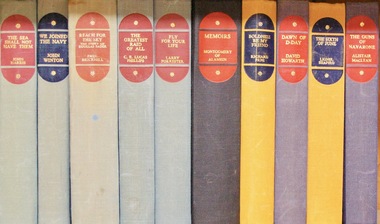
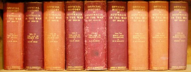 Lara RSL Sub Branch
Book, The Anzac Book Official History of Australia in theWar of 1914-18 Volume III The AIFin France 1916. Author C.E.W. Bean 6th Edition 1938
The Australian Imperial Force in France 1916Historical chronology including colour patches. AIF in France 1916The Anzac Book - Printed 1916 Hardback cardboard Illustrations, maps and diagrams Chronology of 1916egypt, desert line, france, suez canal, camel train, ferry post, armentieres, ypres, aif, battle of fromelles, 5th division, pozieres, mouquet farm -
 Bendigo Military Museum
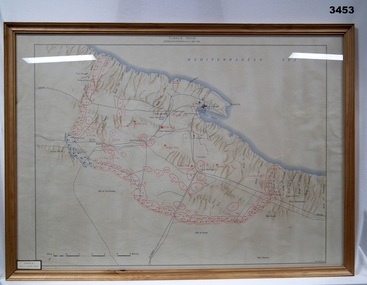
Map - MAP TOBRUK, FRAMED, Post 1941
Coloured map of Tobruk Seige. Lacquered wooden frame, glass front & cardboard backing.Printed top centre: “TOBRUK SEIGE, AUSTRALIAN POSITIONS AS AT 1ST MAY 1941” Donation sticker on bottom LHS. map, tobruk, seige -
 Wycheproof & District Historical Society Inc.
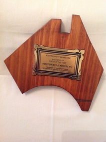
Memorabilia - Plaque, award, 2012
Wycheproof Historical Society in November 2010 co- ordinated and hosted the re- opening of the refurbished Wycheproof Station to great acclaim. The re-opening of the railway station provided a focus on the railway heritage of Wycheproof bringing former railway workers and was supported by Steam Rail Victoria which re-scheduled a train to visit a Wycheproof on the day.wycheproof is a railway town and its major contribution is recognised Varnished brown hardwood map of Australia with rectangular bronze plaque inscription in black lettering.AUSTRALIA DAY AWARD 2012 WYCHEPROOF EVENT OF THE YEAR HISTORICAL SOCIETY. PRESENTED BY WYCHEPROOF VISION SPONSORED BY LIONS CLUB OF WYCHEPROOF.wycheproof vision, lions club, australia day, 2012 -
4th/19th Prince of Wales's Light Horse Regiment Unit History Room
Magazine Publication, Army Directorate of Public Relations, Battle of the Ridges, 2/3/1944
Brochure No 3 - The Australian Army at War. A description of the Wau to Salamaua campaign, with photos and mapsAn official publication -
Phillip Island and District Historical Society Inc.
Book, Aboriginal string bags : nets and cordage, 1999
xv, 157 p. : ill., maps ; 24 cm. Occasional papers, Anthropology and History ; To The Phillip Island and District Historical Society, With best wishes, Alan West, July 2001fibers, string craft, australia, rope, aboriginal australians, industries