Showing 566 items
matching barkers road
-
 Federation University Historical Collection
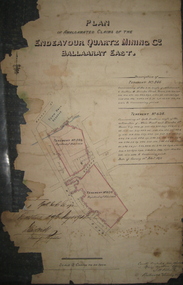
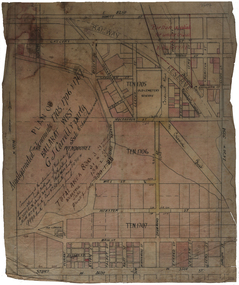
Plan, Plan of the Endeavour Quartz Mining Co., Ballarat East, 1874, 04/01/1874
Hand drawn and coloured paper plan relating to the Endeavour Quartz Mining Co. and tenements 634 and 546. The tenements were along Main Road and Eureka Street in close proximity to the Barkly Street and the Ballarat East Town Hall.ballarat east, endeavour quartz mining co, mining, plan, cgt -
 Federation University Historical Collection
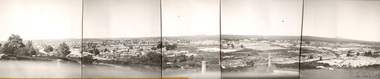
Photograph (Black & White), Keith E. Rash, Ballarat From Sovereign Hill Looking East, 1951
Keith Rash was highly involved in research relating to Ballarat. He took this photo in the Gold centenary year.Six small black and white photographs have been taped together to form a panorama of Ballarat. The Photos were taken from Sovereign Hill and look towards the South East. Geelong Road is evident in the foreground. In the centre of the panorama is Mt Warrenheip, and to the right is Mt Buninyong. Stamped lower right 'K.E.Rash'ballarat, sovereign hill, ballarat east, keith rash, mount buninyong, mount warrenheip -
 Federation University Historical Collection
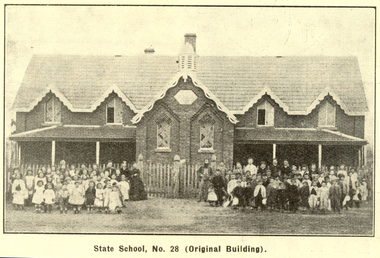
Booklet, Back to Bacchus Marsh, 1930, 1930
The 1930 Back to Bacchus Marsh celebrations were held on 23 to 28 October 1930. The committee were Cr L.M. Gugdale (president), A.W. Bond (General secretary), W. Grant Morton, J.G. Wells, Dr E. McDonald, Charles Dickie, G.H. Anderson, F.M. Crisp, W.R. Vigor. Bacchus Marsh State School No. 28 was established in 1851 as a National School in a rented building on the right-hand side of Bacchus Marsh-Melbourne Road, just beyond Woolpack Inn. Several willow trees mark the site. H.G. Ball was the first Head Teacher of the school, and the enrolmen towas 34. In 1854 Governor Charles Hotham visited the school. In 1855 two new schools, East and West, were recommended. School No. 28 closed in 1862 and the sitre was sold. The present school site was purchased in 1865 for 67 pounds. The cost of the building was 782 pounds. (Visions and Realisations, Vol 3., 1973) A clock purchased by public subscription was placed in the front of the building to the memory of scholars who served during World War One. (Back to Bacchus Marsh, 1930)Brown covered book of 44 pages. Contents include Bacchus Marsh and its soldiers, Red Cross, Lerderderg Gorge, Werribee Gorge, Lerderderg Park, Coimadai, Darely Firebrick Co., Myrniong, Underbank, Balliang, Rowsley, Parwan, schoosl, churches, Shire Council, Federal Milk Pty Ltd, Bacchus Marsh Milk, Old Maddingley Bridge Images include: * Bacchus Marsh looking east, 1930 * Bacchus Marsh Looking West, 1872 * Bacchus Marsh Looking West, 1930 * Aerial View of Bacchus Marsh Township looking east * Aerial View of Bacchus Marsh Township looking south * Bacchus Marsh Agricultural Society & Pastoral Society, 1893 (named), * Original Bacchus Marsh State School No 28 * Holy Trinity Bacchus Marsh * Bacchus Marsh Baptist Church * St Bernard's Catholic Church * Bacchus Marsh Methodist Church * St Andrew's Presbyterian Church Bacchus Marsh * View of Maddingley Park, showing Original Courthouse, 1890 * Werribee Gorge * Underbank Stud Farm * Ballarat State School Number 28. Signed 'C. Hodgson'bacchus marsh, maddingley, maddingley park, underbank, lerderderg park, coimadai, darely firebrick co., myrniong, balliang, rowsley, parwan, schoosl, churches, shire council, federal milk pty ltd, bacchus marsh milk, old maddingley bridge, police, police paddock, maddingley gates, crisp, mccormack, cain, harkness, howe, bence, mcdonald, mcfarlane, cosgrave, flagg, burnip, scott, lodge, cameron, vallance, bacchus marsh state school, bacchus marsh state school no 28., geology, r.w. thompson, lederderg gorge, weribee gorge, comadai, darley firebrick company -
 Federation University Historical Collection
Booklet, J.H. Pollitt, An Historical Record of Melton, c1961
Melton is a town in Victoria.Orange soft covered booklet of 64 pages. Includes sections on Aborigines, John Bull, exploration, survey, early settler, graves, Melton Roads Board, cemetery, common school, churches, agricultural society, rail, Melton weir, index of students enrolled at the Melton Common School in 1864.william dredge darke, samuel staughton, simon straughton, thomas henry pyke, djerriwarrh, charles williams, richard manning, william oldershaw, william yuille, benjamin porter, john ferris, captain moonlight, viaduct, pennyroyal creek, thomas pyke, toolern toolern creek, melton, keilor station, melton weir, melton common school, john bull, melton coursing cup, melton agricultural society -
 Federation University Historical Collection
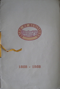
Booklet, John Fraser & Son, Shire of Buninyong 1858 - 1958, 1958
The first Buninyong municipality was established in 1858. The paper for the book was donated by Ballarat Paper Mills Pty Ltd.Cream soft covered booklet with yellow ribbon. The book includes notice of the special meeting, minutes of the 1st and 2nd meeting of the Buninyong District Road Board, images of Archibald Fisken, scenes of Buninyong.'Cr D.K. Coxall'buninyong, archibald fisken, john adams, j macdermott, shire of buninyong -
Federation University Historical Collection
Plan - Plan (copy), Melbourne Road Ballaarat, 1857
This map shows the vicinity of the site of the Eureka Stockade. A3 black and whole photocopy of a plan of Ballarat's Melbourne Road. The plan shows Melbourne Road, Proposed Melbourne Road (later Eureka Street), Chamberlain Street, Queen Street, Allotments between Rodier Street and Stawell Street (William Collard Smith, J & T Oddie, F.A. Edward A. Wynne, David Fitzpatrick, Robert Walsh, Charles Spencer, Alfred Lester, Free Trade Hotel)william collard smith, oddie, wynne, fitzpatrick, walsh, spencer, lester, free trade hotel -
Federation University Historical Collection
Plan (copy), Frederick Proeschel, Map of the Roads to all the Gold Mines in Victoria, 1853
The map was pirated from Frederick Proeschel's "Pocket Map of the Roads to all the Gold Mines in Victoria" issued earlier in 1853.Digital file of the Map of the Roads to all the Gold Mines in Victoria. The map has been coloured to show routes to the Victorian goldfields from Melbourne and Geelong.frederick proeschel, proeschel, gold, mining, philp -
 Federation University Historical Collection
Map, Municipality of Ballarat East, 1857
Gold was discovered in Ballarat in 1851. This plan was created six years later and names some of the great gold locations of Ballarat East. It also shows the locality of the Eureka Stockade (1854) and the walking tracks and roads on the Ballarat East Goldfield.In 2007 this map was listed on the inaugural Ballarat Treasure's Register.Large map backed onto linen. The map has read and blue highlights, and identifies areas such as Mount Pleasant, Golden Point, White Flat, Nightingale, Malekoff, Old Post Office Hill, Red streak, Gumtree Flat, Old Gravelpits, Bakery Hill, Ballaarat Flat, The Camp, Specimen Gully, Pennyweight Hill, Warrenheip Gully, Gays Gully, Pennyweight Flat, Eureka, Black Hill, Pinchgut, Crocodile, Hit or Miss, Little Bendigo, Brown Hill, Mopoke, Cricket Reserve, Canadian Hotel, Ballarat Eastmount pleasant, golden point, white flat, nightingale, malekoff, old post office hill, red streak, gumtree flat, old gravelpits, bakery hill, ballaarat flat, the camp, specimen gully, pennyweight hill, warrenheip gully, gays gully, pennyweight flat, eureka, black hill, pinchgut, crocodile, hit or miss, little bendigo, brown hill, mopoke, cricket reserve, canadian hotel, ballarat eastm phillips, john phillips, field draughtsman, ballarat east, ballarat east map -
 Federation University Historical Collection
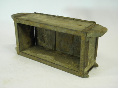
Tool, Brick mould and brick, 1) UNKNOWN .2) c.1888
John Nunn was one of the earliest brickmakers on record in Ballarat and has a road named for him - Nunn Street - where he resided..1) An oblong-shaped timber box open at top. Only butt joints are used. Iron strapping wraps around the vertical pieces of timber and across the top edge of the box. The longest pieces of vertical timber protrude past the end and are shaped like solid handles - one is broken. On each end piece there are small, blank iron plates held with screws. The base piece of timber is made from two different width weatherboard-style timbers. The nails in the base piece appear to be hand-made. Remnants of clay still line the interior. .2) Light brown brick. Please note: Brick mould and brick may be from different sources..1) Handwritten (possibly in ink) on one long side: MR H. G. SMITH ...(illegible) Ballarat .2) Imprinted: J. NUNNjohn nunn, j nunn, brick, mould, brick mould, industrial mould, brickmaker, ballarat, clay, ceramics -
 Federation University Historical Collection
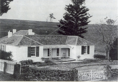
Photograph, Somerset Inn, Bannockburn
The Somerset Inn was built for Edward Carter Holmes by carpenter Isaac Sutherland and his two sons in 1855/1856. Situated on Bruce's Creek on the Shelford - Bannockburn Road. Bruce's Creek was the original name for current day Bannockburn. Black and white photograph of a house with slate roof and window shutters. The front fence is stone. The house is the former Somerset Inn (later a private residence). This building is located on the Leigh River at Bannockburn and was the home of Edward Carter and Sarah Holmes. Verso in blue ball point pen. "Somerset Inn on Leigh river Bannockburn. Home of Edward C. & Sarah Holmesholmes, leigh river, sarah holmes, ec holmes, holmes family collection, chatham-holmes family collection, edward carter holmes, farm, bannockburn -
 Federation University Historical Collection
Plan, Haddon, County of Grenville, 1932, 13/04/1932
The Haddon Parish Plan shows crown parcels government roads, Crown Reserves, Railway. Scale 40 chains to 1" (1:31, 680) WGS 84 Centroid Lat: 37 degrees 34' 00" S Long: 148 degrees 40' 20" E N.S. 9.3km E.W.: 16.1kmhaddon, grenville, cardigan, water supply reserve, nentingbook pre-emptive right, a. mclachlan, lake burrumbeet, e.a. wynne, p. russell, b. hepburn, benjamin hepburn, nentingbool, t.c. wilson, j. amoy, william collard smith, james roach, j. mitchell -
 Federation University Historical Collection
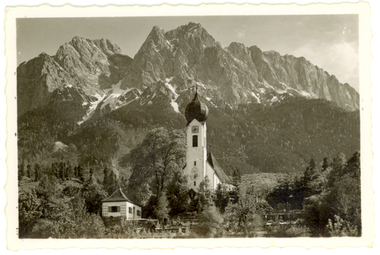
Photograph - Photograph - Black and White, Church at Garmisch-Partenkirchen, Bavaria, Germany
Garmisch (in the west) and Partenkirchen (in the east) were separate German towns for many centuries, and still maintain quite separate identities. Partenkirchen originated as the Roman town of Partanum on the trade route from Venice to Augsburg and is first mentioned in the year A.D. 15. Its main street, Ludwigsstrasse, follows the original Roman road. (Wikipedia)A church stands before large mountains in Garmisch-Partenkirchen, Bavaria, Southern Germanychatham family collection, garmisch-partenkirchen, bavaria, germany, church, alps -
 Federation University Historical Collection
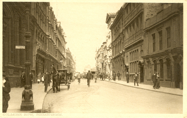
Postcards, Birmingham
Two black and white postcards of Birmingham. .1) Bull Ring, Birmingham featuring a church and steeple in the mid background and people waling in the streets. .2) Colmore Row, Birmingham featuring three storey buildings on either side of a road. People walk on the footpath and a horse and carriage are parked on the left. -
 Federation University Historical Collection
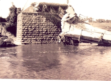
Photograph - Photographs, Richard Vincent, Washed Away Bridge at Garibaldi, c1933
Newspaper clipping documents deputations to the Minister of Public Works for grants to be made available for repairs to bridges and roads damaged by heavy flooding in 1933, in particular, the replacement of a stone and concrete bridge over the Leigh River at Garibaldi in the Buninyong Shire. The concrete slabs were still in the water in the 1960s/70s or even later. Three black and white photographs showing flood damage to the bridge over the Leigh River at Garibaldi, plus a photocopy of a newspaper clipping from The Argus December 1933 describing the extent of the flood damage. .1) shows blue stone buttress and collapsed bridge/road. .2) mirror image of above .3) unknown man waling an a girder of the Garibaldi bridge .4) photocopy of newspaper clipping about flood damage from The Argus December 1933Damage by Floods: Bridges washed away (The Argus December 1933)leigh river, garibaldi, buninyong shire, richard vincent, garibaldi bridge -
Federation University Historical Collection
Booklet, Open Monument, Ballarat, 2015
Soft covered booklet of 41 pages covering the Open Monument by John Young. 'Open Monument' comprises 2 artworks: A 33 laser-etched granite paneled work, 'transculture', and 'Timeline' which extends of 40 metres and depicts the major contributions of the Chinese community in Ballarat, every decade from 1850 until the present. The timeline then folds out with anticipation to 2070. Each page describes aspects of the monument and the Chinese influence. An timeline of Chinese influence is given at the back of the book.non-fictionchinese, mining, multicultural, immigration, tong way, goon, joss house, embroidery, billy butterfly, chinese market gardens, red lion hotel, ah soon, mayor of main road, chinese herbalist, yee lee, james hong, cheok cheong hong, john ah loo, wathawurrung, robe, lowe kong meng, louis ah mouy, tongway, gallipoli, william lung -
Federation University Historical Collection
Letter - Photocopy of letter, Letter regarding the naming of Vincent Drive, Mount Helen, 1984, 1984
Provides information about the naming of Vincent Drive Ballarat University 1984. Vincent Drive was named in recognition of the years of service Richard Vincent gave to the Shire of Buninyong as a councillor.Photograph of letter plus a Ballarat University campus map showing Vincent Drive, plus a newspaper clipping and photocopy of the clipping regarding a new access road to the Ballarat Technology Park ( The Courier, Ballarat, Tuesday, March 19,1996).vincent drive, federation university, buninyong shire, ballarat university, ballarat technology park -
 Federation University Historical Collection
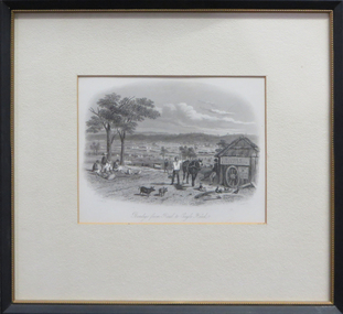
Work on paper - Artwork (framed), Bendigo from Road to Eagle Hawk by S.T.Gill, 1857
Framed steel engraving by Tingle from 'Victoria Illustrated' Melbourne 1857s.t.gill, j.tingle, bendigo, eagle hawk, steel engraving, available -
Federation University Historical Collection
Plan, Plan of Mount Helen, 7/7/1964
Plan of Subdivisions to Mount Helen, Shire of Buninyong, Sheet 1 and Sheet 2 Scale 200 feet to one inchmidland highway, gear avenue, eddy avenue, shire avenue, boak avenue, moss avenue, rathkeale avenue, ingliston avenue, chatham avenue, mardango drive, nyora grove, yarana drive, shakespeare avenue, marina avenue, landale avenue, lylia avenue, recreation road, olympic avenue, the gums, heather avenue, dallas avenue, jones avenue, sebastopol mount clear road -
Federation University Historical Collection
Book, Victoria Australia: Innovation Events Energy
Blue hard covered book with dust jacket.holden, university of ballarat, smorgon steel, dennis family, melbourne water, tattersall's, east gippsland institute of tafe, gippsland water, multicultural victoria, murray goulburn co-operative, bendigo mining nl, mccain foods, melbourne docklands, mccain foods, melbourne cricket ground, olympic park, state library of victoria, great ocean road, lavendula, grampians, gippsland, bhp billiton -
 Federation University Historical Collection
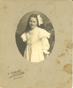
Photograph - Photograph - Black and White, S. Fisher Johnson, Edith Pickford (Holmes)
Edith Sarah Pickford was born and raised in Clunes, Victoria. She is the only daughter of John Pickford and Betsey (Robbins) Pickford and sister of Henry Pickford, John Pickford, William Harold Pickford, Horace Pickford DCM, Arthur Pickford and Charles Alexander Pickford. Edith's maternal grandmother was a descendent of Donald Cameron, the first recorded European settler in the Clunes area.The Pickford family's pioneer settler legacy in the Clunes- Glendaruel district is commemorated with a Pickford Road and displays in the Clunes Museum. A collection of Edith's song music was donated to the Clunes Museum by her great grand-daughter in 2023. Edith married a local farmer, Henry Smerdon Holmes from "Sauchieburn" Ascot, Victoria. Henry was a descendant of the family who had inherited their maternal ancestor's, Catherine Coghill (nee Holmes), Ascot - Coghills Creek property. This branch of the Coghill Family descended from the district's pioneer settler, Captain Coghill. Edith and Henry spent all their married life, and raised 4 children Jack [John], Bill [William], [Mary] Elizabeth and David, at Ascot. She was buried in the Coghills Creek Cemetery with her husband, Henry Smerdon Holmes, and their son, David, in 1967. Her children, Bill Holmes and Elizabeth Chatham, and their spouses are buried nearby.Social and historicalMounted black and white photo of a young girl wearing a white dress and ribbon.chatham holmes collection, holmes, pickford -
 Federation University Historical Collection
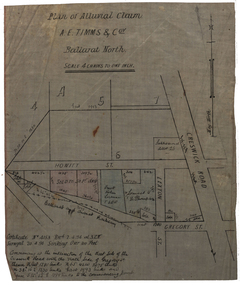
Plan, Plan of Alluvial Claim of A.E. Timms and Co, 1894, 02/04/1894
This item was removed from Catalogue Number 3601Plan of a lease located near Cresick Road. Scale: 4 chains to 1 inch (1:3168) WGS 84 37 32 35 South 143 50 50 Easttimms, a.e. timms & co., howitt st, ballarat north, creswick road, alluvial claim, mining -
 Federation University Historical Collection
Plan, Plan of Amalgamated Tenements for G.J. Carroll and Party, Ballarat West
g.j. carroll and party, carroll, g.j. carroll, webster street, mill street, mair sreet, sturt street, ballarat railway, ballaarat old cemetery, crewsick road, gregory street\sussex street, errard street, raglan street, lyons stret, dawson street, howitt street, ascot street, ripon street, talbot street, windermere street -
 Federation University Historical Collection
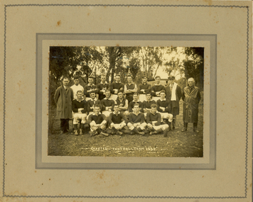
Photograph, N.R. McGeehan Photo, Gapsted Football Team, 1932, 1932
Gapsted is on the Great Alpine Road in the vicinity of Myrtleford, Victoria. John McNaughton studied at the Ballarat Teachers' College in 1929. He was most probably the teacher of Gapsted Primary School in 1932.Mouned black and white photograph of an Australian Rules football team and two officials. The official on the left is John McNaighton.gapsted, gapsted football team, mcnaughton, john mcnaughton -
 Federation University Historical Collection
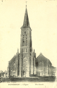
Postcard - black and white, Church at Dickebusch, c1916, c1916
A Commonwealth War Graves Commission (CWGC) burial ground, the Dickebusch Old Military Cemetery, is a burial ground for the dead of the First World War and the Second World War. It is located at Dickebusch in the Ypres Salient in Belgium on the Western Front of the first war. Dickebusch (now Dikkebusch) is a village and commune in the Province of West Flanders, 5 kilometres South-West of Ypres on the road to Bailleul.Black and white photograph of a church with a steeple with a clocktower. The church was bombed in 1917 during World War One. This card was purchased by an Australian soldier, probably Henry Smerdon Holmes, during World War One. chatham-holmes family collection, dickebusch, belgium, ypres salient, dikkebusch, world war one -
 Federation University Historical Collection
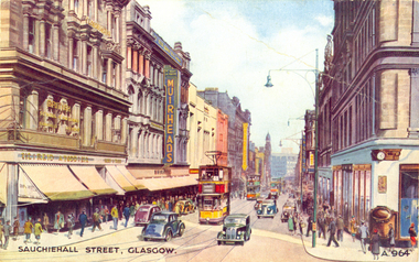
Postcard - colour, Sauchiehall Street, Glasgow
auchiehall Street /ˈsʌxihɔːl/ is one of the main shopping/business streets in the city centre of Glasgow, Scotland. Along with Buchanan Street and Argyle Street, it forms the main shopping area of Glasgow, containing the majority of Glasgow's high street and chain stores.[1] Although commonly associated with the city centre, Sauchiehall street is over 11⁄2 miles (2.5 km) long, finally meeting Argyle Street in the West End, in front of the Kelvingrove Museum, where they form Dumbarton Road which continues through Partick. The two streets run parallel through the city centre, before starting to conjoin westward of the M8 motorway at Charing Cross. (Wikipedia)Colour postcard of a street with cars, double decker buses and four storey buildings. The street is Sauchiehall Street, Glasgow, Scotland.chatham-holmes family collection, glasgow, scotland, double decker bus -
 Federation University Historical Collection
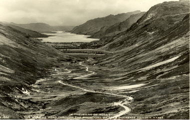
Postcard - black and white, J.B. White Ltd, In the Wilds of Rosshire - The Winding Road Through the Mountains of Glen Docherty to the Loch Maree
Volcanic activity in this region ceased about 50 million years ago, after which the landscape was shaped by glaciation from about 1.8 million years ago to the end of the Great Ice Age about 10,000 years ago. The U-shaped glen of Glen Docherty is typical of a glen formed by the action of glaciers. (wikipedia)Black and white photographic postcard showing a road running between Glen Docherty and Loch Maree. The A832 road runs through the glen.chatham-holmes family collection, rosshire, glen docherty, loch maree, mountains, scotland -
 Federation University Historical Collection
Postcard - photographic, High Street, Salisbury, Wiltshire, England
Salisbury is a cathedral city in Wiltshire, England, and the only city within the county. It is the 2nd-largest settlement in the county with a population of 40 302, between Chippenham at 35 800 and Swindon at 209 156. (Wikipedia)Black and white photographic postcard showing a road lined with three storey buildings. chatham-holmes family collection, salisbury, postcard -
 Federation University Historical Collection
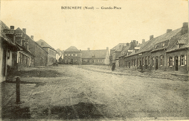
Postcard - black and white, Grande-Place, Boeschepe, c1914
Boeschepe is a commune in the Nord department in northern France, next to the Belgian border.Black and white postcard showing a number of buildings lining an unmade road. chatham-holmes family collection, boeschepe, france, world war, world war 1, grande place -
 Federation University Historical Collection
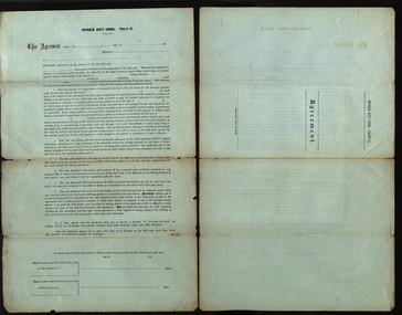
Document, A.J. Peacock, Agreement under the Mines Act 1890, 13/02/1919
Richard Squire was a graduate of the Ballarat School of Mines. He worked a number of mines in Victoria..1) Large legal document under the Miners Act 1890 Part 2, between Allan A. Fraser of Meredith and Richard Brereton Squire of 66 Lewisham Road Windsor, Victoria. A seal has been attached to the two signatures. .2) blank formSigned by Allan A. Fraser and Richard B. Squire. Both signatures witnessed by Annie Marchment.mining, mines act, mines act 1890, squire, richard squire, fraser, marchment, annie marchment, meredith, windsor, grenville, lalalute -
 Federation University Historical Collection
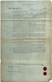
Document, Agreement under the Miners Act, 1890, Part 2, 1919
Richard Squire was a former student of the Ballarat School of Mines. A large sheet of paper with seals - an agreement under the Miners Act, 1890, Part 2 between Richard Brereton Squire of 66 Lewistram Road, Windsor and Alfred Rice of Mt Mercer. The agreement is unsigned, but dated 1919. Gift of the Squire Family, 2014squire, richard squire, ballarat school of mines, alfred rice, mt mercer, mining, mount mercer