Showing 965 items
matching dams
-
 Wodonga & District Historical Society Inc
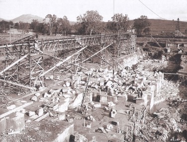
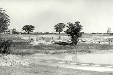
Album - Hume Reservoir Australia Album - Foundation work and dam construction, June 1924
This set of photos is from a leather bound album bearing the inscription "HUME RESERVOIR AUSTRALIA" plus 'The Rt. Hon. L. C. M. S. Amery, P. C., M .P.' all inscribed in gold. It was presented to The Rt. Hon. L. C. M. S. Amery, P. C., M. P, Secretary of State for Dominion Affairs on the occasion of his visit to the Hume Reservoir on 2nd November 1927. This album is of local and national significance as it documents the planning and development of the Hume Reservoir up to 1927. It was the largest water reservoir in the British Empire. The album records the pioneering engineering work that went into its construction.DEPARTMENT OF PUBLIC WORKS, N.S.W. RIVER MURRAY WATERS SCHEME. HUME RESERVOIR. 13. Foundation work and dam construction proceeding inside levee bank which may be seen at the right hand end of the work, New South Wales, June 1924.hume reservoir australia, river murray waters scheme, hume reservoir construction -
 Kiewa Valley Historical Society
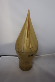
Pendulum weight
The pendulum weight was used to define a vertical line. Being so large and heavy it was possibly used from a tower or a dam. It was held by one end of a wire and measured any tilt of the structure in any direction.Possibly used on the Kiewa Hydro Electric Scheme during the construction of the dam walls and Electric Powerline towers.Cone shiny brass pendulum weight with cylinder shape that i hollow at one end. The hollow is threaded inside. The part that fits the hollow end is missing.pendulum weight, measurement, kiewa hydro electric scheme -
 Stawell Historical Society Inc
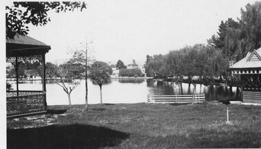
Photograph - Valentine Series No. 1082 Lake Victoria Park, Stawell, Victoria Park Stawell with two Rotundas one cast iron and one wood (Now Cato Park)
Valentine Series Postcard. Victoria Park later Cato Park at Head of the St George Mine Dam originally established with donations from Mr E Simmons and voluntary efforts. Shows two rotundas.B/W Photo. Valentine Series No. 1082 Lake Victoria Park, Stawell. Taken between the two rotundas showing lake, pier and older willows. Both now renamed Cato lake and Cato park.Valentines Real Photo Series Logo. Published by the Valentine Publishing Co. Pty. Ltd. Queen St. Melb.stawell -
 Linton and District Historical Society Inc
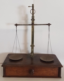
Scales, Gold Scales
Understood to have been used in Linton c.1864. Information provided in 1993 by Russell McDonagh Bennett suggests these scales may also have been used at Dawsons Dam mine c.1907-1909.Beam scales used for weighing gold. Scales consist of two circular metal dishes, each supported by three wires suspended from a metal balance (beam), which in turn is linked to and supported by a vertical metal stand. A lever attached to the stand can be used to move the weighing dishes vertically and horizontally. The scales are mounted on a rectangular wooden box with a sliding drawer which is divided into three compartments.Maker's marks stamped on dishes, lever and stand. Date "1863" stamped on lever, also (in smaller letters) "10.8.1864".gold scales -
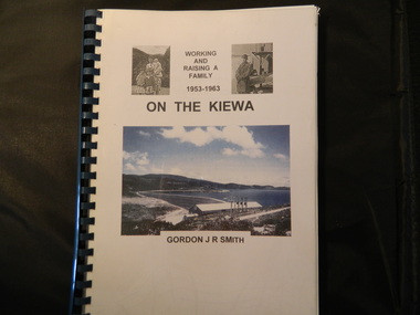 Kiewa Valley Historical Society
Book - On the Kiewa, Working & Raising a Family 1953 - 1963 by Gordon J. R. Smith, 9th September 2005
Personal account of Gordon Smith's life when living in Mt Beauty and Bogong townships while working for the SECV on the Kiewa Hydro Electric Scheme.Gordon gives an account of both working and living during the 1950s and early 1960s in a remote part of Victoria - the Kiewa Valley and in 2 small construction towns. He gives a lot of detail eg. the weather, his work, the people, the activities, his family and leisure time.Plastic threaded spine holding 282 pages with black and white photos. Front Cover includes 2 small black and white photos either side of the title at the top and below the title a larger colored photo of Rocky Valley Dam. Author's name is underneath. "Dick Puttyfoot" on cover page.kiewa hydro electric scheme, state electricity commission of victoria., gordon smith -
 Federation University Historical Collection
Photograph, Site of Sovereign Hill and Ballarat Lodge
The Old Ballarat Travel Inn was located at 613 Main Road. It later Became Ballarat Lodge and Mecure Ballarat.Photograph showing the site of Sovereign Hill in fron to the pine trees, and Elsmore street running along the right. Ballarat Lodge, the brainchild of John Gilbert, can be seen in front of the dam in the centre. The start of Magpie Street can be seen on the left hand side of the photograph.ballarat lodge, john gilbert, sovereign hill, elsmore street, main road, ballarat east, old ballarat travel inn -
 Lakes Entrance Historical Society
Photograph - Mossiface Flats, Tambo Shire, 1994
Also second identical copyColour photograph of the Mossiface Flats, near Bruthen, shows paddocks of the rich river flats, timbered foothills in the distance, with mountain range behind. Some paddocks have been mown for grass hay. Farm buildings in foreground and background. Dam in foreground. Bruthen Victoriaanimals, agriculture, vegetation, topography -
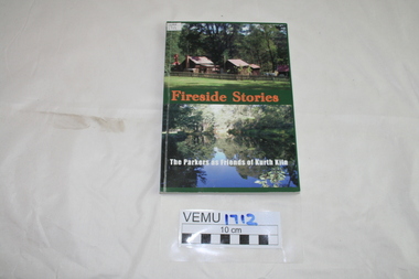 Emerald Museum & Nobelius Heritage Park
Book, Friends of Kirth Kiln, Fireside Stories, The Parkers as Friends of Kurth Kiln, February 2010
Kith Kiln was the site of a short lived charcoal kiln designed to provide an alternative to petrol during World War 11 when there was a fuel shortage. Local history has been told by Genseric (Bill) Parker and the reflections collected by Friends of Kirth Kiln (under the auspices of Parks Victoria).The booklet is significant because it tells the story of the development of the Kirth Kiln Park in Gembrook, from the Friends perspective.The park is not only historical but is also of great environmental significance and it forms part of community life in the district. Green soft cover booklet of 128 pages. The front cover has 2 photos; the top one of the caretakers compound with Forest Commission huts and the bottom photo is of the Lake, taken from the dam on Tomahawk Creek. The back cover has a diagram of the Kiln logo.Fireside Stories with Genseric (Bill) Parker and Lorna Parker. Reflections collected by Friends of Kirth Kiln.kirth kiln, genseric parker, parks victoria, gembrook, charcoal burner -
 Federation University Historical Collection
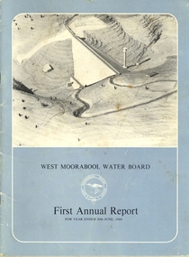
Book, Exchange Press Pty Ltd, West Moorabool Water Board First Annual Report For The Year Ended 30th June 1969, 1969
Documents the concept, construction and management of the Bungal dam built on the West Moorabool River in 1972 to safeguard the water supplies of Geelong and Ballarat. Provides details of the history, the West Morrabool Water Board and its members, the Act and finances.BookInk on paperlal lal, gordon, bungaree, wallace, lal lal, kerrit bareet, buninyong, bungal, lal lal reservoir, bungal dam, mt egerton, hopwoods hill, gordon, fiskens hill, green hill, mt buninyong, clarendon, r.g. biggs, w.f. stephen, r.a. horsfall, w.a. borthwick, t.m. conroy, sir henry bolte, west moorabool water board -
 Old Gippstown
Building - Miner's Hut
This hut came from the Tanjil goldfields, and was in use around 1900, and was the home of two miners on the Tanjil River gold field. The township of Tanjil came into being above what is now the Blue Rock Dam, in about 1867.A small, rectangular bark hut with a bark roof. The fireplace and chimney are made of corrugated iron with stone base. It has a timber framework.tanjil, gold, mining, old gippstown, west gippsland, gippsland, gippsland heritage park, goldfields, moe, historical village, tanjil valley, blue rock dam, baw baw shire, blue rock lake, old gippstown heritage park, latrobe valley, latrobe city council -
 Stawell Historical Society Inc
Headwear - Portrait, Bro Edmund Gray, 1908
Mr Edward Gray An old Pioneer - Miner Born Aberdeen Scotland 1839 Died Stawell 21/9/1908 Accidently Drowned in Moonlight Dam One of the founders of M.U.I.O.O.F. Lodge Grand Master of Masonic LodgeCopy of photograph of man in suit. Head and shoulders.In Memory of Bro E. Gray. P.S.W Died Sept 21 1908 -
 Melbourne Water
Photograph, Upper Yarra Dam Personnel, 1955
As the Yarra became unsuitable as a source of water, several attempts were made to find alternative sources for the growing population of Melbourne. It was not until 1891 that the efforts to sewer Melbourne came to fruition with the setting up of the Melbourne Metropolitan Board of Works (MMBW), now known as Melbourne Water. From 1891 until 1992, it was the responsibility of the MMBW to safeguard public health by providing a sewerage system and a safe water supply system. In 1992, The MMBW merged with a number of smaller urban water authorities to form Melbourne Water. In 1946, the Melbourne and Metropolitan Board of Works (MMBW) approved a site for a new dam for Melbourne's domestic water. This is now known as the Upper Yarra Dam. Due to the construction of the dam, the workforce had to be accommodated on site; domestic quarters were built for single men, families and staff. The township also had kitchens, laundry facilities, a canteen, a recreation hall, mess areas and a co-op store, with one of the first houses being seconded to accommodate for a school. This photograph shows personnel at a Kindergarten party at the Upper Yarra Dam, a time where workers were housed during its construction. The photograph is historically significant as it captures a purpose built community that supported the workers undertaking the construction of the dam. upper yarra dam, mmbw, melbourne metropolitan board of works, township, 1940s, community -
 Bendigo Historical Society Inc.
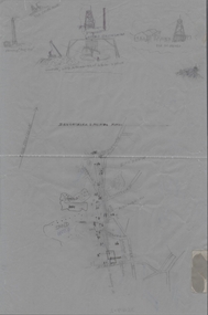
Plan - MCCOLL, RANKIN AND STANISTREET COLLECTION: PLAN OF SURVEY OF DAM SITE, 1941
McColl Rankin & Stanistreet, Plan of Survey of Dam site, Part of Crown Allotment 98 Section C, City of Bendigo, Parish of Sandhurst, County of Bendigo. Signed by Garnet G Birch 1 Feb 1941. 33.5 x 43. Attached is a Copy of Field notes, Dam Site in Crown Allotment 198 Sec. City of Bendigo, Parish of Sandhurst. True Meridian, County of Bendigo, Area 0A 1R 16P. Signed Garnet G Birch, 1/2/1941. Drawn in red and black pen. 20.8 x 33. Both maps are for Deborah Extended Gold Mining Co. No Liabilityorganization, mining, deborah extended gold mining co nl, mccoll rankin & stanistreet, plan of survey of dam site -
Creswick Campus Historical Collection - University of Melbourne
Still Image, Photographs from the VSF Creswick during the 1930s, 1930-1939
6 photographs from the VSF during the 1930s6 photographs from the VSF during the 1930s. 1464.01 b&w photograph State Nursery Dam, Creswick, 1939 / b&w photograph Government Dam, Creswick, 1939 / b&w photograph of Main Drive of VSF, Creswick, 1939, 1464.02 b&w photograph VSF Students 1933 L. to R. Jack Newey, Murray Thompson, Colin Davidson, Wally Caplehorn / 1464.03 sepia photograph, postcard format of VSF building Creswick approx 1930s. / 1464.04 sepia photograph VSF Creswick students H Payne, J. Willis, 1 unknown and staff, W. Lister -
 Learmonth and District Historical Society Inc.
Photo, "Willow Vale" Waubra, Victoria, Late 19th Century or Early 20th Century
It show the farm "Willow Vale" Waubra that was once owned by the Christopher and Selina (nee Smith) Harrison family who once lived on this farm and whoes descendants continue to live in the same area today.A very pale sepia photo of the "Willow Vale" farm at Waubra, Victoria that was owned by Christopher and Selina (nee Smith) Harrison. It shows a horse and buggy, along with the main house/houses and out buildings with what look like it could be a slightly dry dam at the bottom of the photo.Nil -
 Bendigo Historical Society Inc.
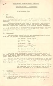
Document - STATE RIVERS AND WATER SUPPLY COMMISSION : EPPALOCK PROJECT - CONSTRUCTION
State Rivers and Water Supply Commission headed six page document, stapled. Subtitled: ' Eppalock Project - Construction. Some Technical Notes.' Information typed under subheadings: Dam, Embankment, Spillways, Outlet works, proposed hydraulic driven pumps, road deviations. Undated.state infrastructure, water supply, coliban system, state rivers and water supply commission. coliban system. eppalock. -
 Bendigo Historical Society Inc.
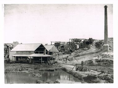
Photograph - WES HARRY COLLECTION: MINING LANDSCAPE BENDIGO
Black and white photo copy : image shows line of whims descending towards open shed like building in front of mining dam. On RH side brick chimney. Potentially, the same area as shown in image 2402.237 (see mine sheds, brick chimney and whims).Batchelderplace, bendigo, mining landscape -
 Bendigo Historical Society Inc.
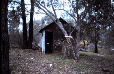
Slide - PETER ELLIS COLLECTION: SLIDE, May 1970 - Jan 1972
Coloured slide transparency. Image is of a hut in the bush. The hut is of iron sheet construction, with a brick oven at the front. A sign with the words Red Box Hut is attached to a tree at the front and a dam is on the left hand side of the hut. The words Red Box Hut are handwritten on the top border.Kodachrome Transparencyslide, bendigo, bendigo institute of technology -
 Bendigo Historical Society Inc.
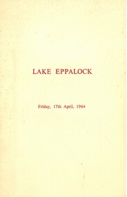
Document - LAKE EPPALOCK OPENING CEREMONY PROGRAM 1964
Cream folded program. On front 'Lake Eppalock, Friday 17th April 1964, printed in brown text. Inside: State Rivers and Water Supply Commission, Ceremony to mark the completion of the Eppalock Dam and Pumping Station and the Eppalock-Bendigo Pipeline, Friday 17th April 1964.bendigo, waterworks, lake eppalock -
 Bendigo Historical Society Inc.
Document - DEVONSHIRE & MUNGO MINES - LOCATIONS OF THE DEVONSHIRE & MUNGO MINES
Tracing of streets, school sand heaps and dam at Eaglehawk titled Devonshire & Mungo Mines. At the top of the page is sketches of the chimney of the 'Big 180', Old Chum Mine, United Devonshire and Old St Mungo Mines. Also, a sketch of a windlass, whip & remains of whim. Eaglehawk.mine, gold, devonshire & mungo mines, devonshire & mungo mines, locations of the devonshire & mungo mines, eaglehawk, chimney of the big 180, old chum mine, united devonshire, old st mungo -
 Halls Gap & Grampians Historical Society
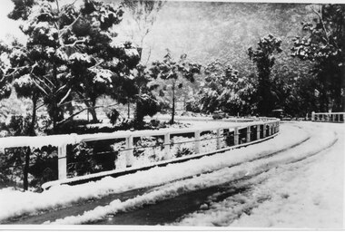
Photograph - B/W, C 1940
The third Delley's Bridge, built in 1940 with a curved deck, was situated slightly upstream from the previous bridge. Though it was subject to snow cover from time to time, raging floodwaters were not a threat after Bellfield Dam was built in the 1960s.The picture shows a curving bridge with a wood and wire railing. The bridge and surrounding trees are covered in snow.structures, bridges -
 Bendigo Historical Society Inc.
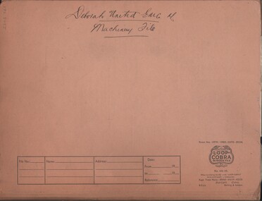
Document - MCCOLL, RANKIN AND STANISTREET COLLECTION: DEBORAH UNITED GOLD MINING CO. MACHINERY FILE, 1940 - 1945
Document: McColl, Rankin & Stanistreet Deborah United Gold Mining Co. Machinery File. Buff fooscap folder. Letters enclosed relate to machinery e.g. quotations for machinery repairs and purchases, tenders for dam, erection of winding plant and poppet legs. August 1940 - December 1945.McColl, Rankin & Stanistreetorganization, business, deborah united gold mine nl, mccoll, rankin & stanistreet, deborah united gold mining co., gold mining, machinery, poppet legs -
Bendigo Historical Society Inc.
Document - MINING REPORTS - MINES ACT 1890, ALTERATION OF REGULATIONS
Printed document Mines Act 1890, Alteration of Regulations. Refers to an addition to clause 20 of the Regulations relating to licences to cut, construct, and use races, drains, dams, and reservoirs. The additional Regulations shall extend to all Water-right Licences. Document is part of the Albert Richardson Collection. document, gold, mining reports, mining reports, mines act 1890 alteration of regulations, mr munro, mr shiels, sir f t sargood, mr duffy, mr wheeler, mr davies, mr outtrim, mr fraser, g wilson brown, robt s brain -
 Kiewa Valley Historical Society
Leaflet - Kiewa, Welcome to Kiewa
The State Electricity Commission of Victoria constructed the Kiewa Hydro Electric Scheme from 1938 to 1961. The Scheme included three power stations, dams, tunnels and was becoming a popular tourist destination with Falls Creek Ski field within its boundaries.This leaflet was published by the SECV to ensure all visitors to the Kiewa Hydro Electric Scheme were made aware of safety measures with regard to their driving and to bush fires. These were necessary as the area was unique with driving on mountainous roads, changeable and extreme weather and the threat of bush fires. The gatehouse existed during construction, when the SECV was in charge, as a restriction to entry to the Scheme for SECV workers and those with permission to enter. The SECV controlled the area so in case of accident, the SECV was the body to contact not eg. the police.Small white and green leaflet made from one sheet of glossy paper and folded in half. Front cover has the title in the middle, the SECV emblem at the centre top and across the bottom is a message to read the inside pages which are safety messages for driving and bush fires. The back cover has a RACV road map of Kiewa and its 'works' including the Gatehouse which was the entrance to the scheme.The map also has an insert of the main roads & nearby cities. state electricity commission of victoria; kiewa hydro electric scheme; gatehouse; safety rules; kiewa -
 The Beechworth Burke Museum
Photograph, Unknown c.1930s
This image shows Bethanga Bridge, which was constructed between 1927 and 1930 in Albury, NSW. The bridge was a necessity due to the building of the Hume Dam (Wier), 1919-1936. Bethanga Bridge is a long, nine-span, riveted-steel, variable depth, Pratt Truss road bridge of nine principal spans of 82 metres and a total length of 752 metres over the flooded valley of the Murray River, now part of Hume Reservoir. Because of its unique location, over the waters of a dam with the border running down the centre of the body of water, the Bethanga bridge is the only built structure shared by both New South Wales and Victoria. It was built 1.6 kilometres upstream of the dam and in 1961 was raised 300mm, with a concrete deck replacing the original wooden deck. The State Rivers and Water Supply Commission of Victoria and the New South Wales Department of Public Works were responsible for the construction works for the Hume Weir under the River Murray Waters Agreement. It is apparent that a similar joint arrangement was made for the construction of the Bethanga Bridge as part of the Hume Weir works.This photograph of the Bethanga Bridge is of historical significance as it showcases the architectural skills of Percy Allen and Vincent Packer. Additionally, it reveals the environmental landscape of the 1920s-1930s, is linked to the Hume Dam and both New South Wales and Victorian heritage. Unmounted black and white rectangular photograph. Reverse: 1997.3196 84-20-3bethanga, bethanga bridge, hume dam, pratt truss, murray river, hume weir, transportation -
 Federation University Historical Collection
Photograph - Black and White, Federation University Albert Coates Complex under construction, 1972
Fiver black and white photographs showing the former Union Building, now the Federation University Albert Coates Complex, under construction. .1) View of the first stage residences site south west, shows Stage 1 Engineering and Metallurgy/Geology. .2) View of the first stage residences site to the South west. Roadway dam creates upper pond. .3) View of the first stage residences site to the eastward. Shows lower pond and roadway dam. .4) View of the first stage residences site to the South. Start of Union Building Construction. .5) .View to the south east across lower pond, shows the Tree of Knowledge and first stage buildings.albert coates complex, union building, mount helen campus -
 Melbourne Royal
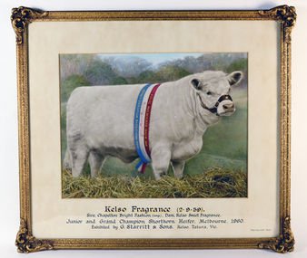
Photograph, Kelso Fragrance (2.9.59), 1960
Portrait of Kelso Fragrance, the Junior and Grand Champion Shorthorn Heifer, exhibited by G. Starritt in 1960. George 'Ray' Starritt OBE joined the Society in 1957, with his father founded the Kelso Park stud, originally for sheep, in 1914. Starritt became a Life Councillor of the RASV in 1977, and held the office of Vice President for 12 years before taking on the presidential seat from 1982 to 1986.Colour, landscape photograph in gilt frame with glass front, wire hungKelso Fragrance (2.9.59) / Sire, Chapelton Bright Fashion (imp.), Dam, Kelso Sweet Fragrance / Junior and Grand Champion Shorthorn Heifer, Melbourne, 1960. / Exhibited by G. Starritt & Sons, Kelso, Tatura, Vic. / 525.3933 /shorthorn, cattle, cow, heifer, starritt, g starrit, george starritt, ray starritt, livestock, blue ribbon competition, winner, grand champion -
 Bendigo Historical Society Inc.
Photograph - VICTORIA HILL, approx 1875
Black and white photograph showing 2 poppet heads, 3 chimneys, dam, 2 wood stacks, associated sheds, mine manager's house, few trees. Copy of photograph ' New Chum Reef - looking north N.J. Caire photo 1875 - copy J. Lerk, 11.2.2000'N.J. Caire ?place, landscape view, new chum reef -
 Bendigo Historical Society Inc.
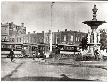
Photograph - BASIL MILLER COLLECTION: PHOTOGRAPHIC COPY OF CHARING CROSS, Between 1892 - 1903
BHS CollectionBlack and white photo copy of Businesses on Pall Mall and Mitchell St corner. Alexandra fountain on right. 2 steam trams and trailers on left. J.T. Hill - Tailor (No. 8 Pall Mall), Van Dam's- Tobacconist (No. 4 Pall Mall). 'Photo by A. Doney, Bendigo' stamped on back.A. Doneyperson, individual, basil miller -
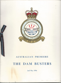 Melbourne Legacy
Programme - Document, programme, Australian Premiere. The Dam Busters, 1956
The Australian premiere of the film The Dam Busters was screened at the Windsor Theatre on 2nd of May 1956. It was attended by the Governor of Victoria, General Sir Dallas Brooks and his wife, Lady Brooks. Proceeds from the evening was donated to Melbourne Legacy and The Air Force Association.A record that Legacy used film screenings for a fundraising event. It was attended by the Governor who was patron of Legacy.Printed programme of a film premiere in aid of Legacy, cover has the 617 squadron emblem. Black and white photos and advertising inside. A glossy card cover and paper pages, with a decorative ribbon in the side. Also a ticket wallet with a Lancaster bomber image.fundraising, governor of victoria, gala performance