Showing 10893 items
matching land
-
 National Vietnam Veterans Museum (NVVM)
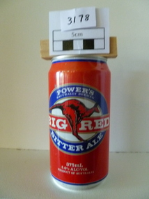
Memorabilia, Beer Can
Red, blue and white can - Poers Big Red Bitter Ale. Kangaroo bounding on front. Australian Vietnam Forces National Memorial Canberra 1992 on back.Power's Big Red Bitter Ale, Australian Vietnam Forces National Memorial Canberra 1992beer can, australian vietnam forces national memorial, national memorial canberra 1992 -
 Wheen Bee Foundation
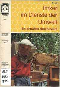
Publication, Imker im Dienste der Umwelt: ein sinnvoller Nebenerwerb, Bonn, 1975, 1975
-
 Melbourne Athenaeum Archives
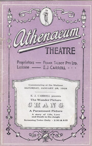
Theatre Program, Cass & Clothier (Printers), Chang (film) : A Drama of the Wilderness screened at the Athenaeum Theatre in 1928, 28/01/1928
The last silent film to be shown at the Athenaeum Theatre presented by E J Carroll. The theatre was managed by Frank Talbot Pty Ltd during his long lease of the theatre following his major renovations when Henry White the architect built an intimate theatre inside the old Athenaeum Hall. In addition to musical accompaniment for the film, the orchestra, and sometimes singers entertained audiences before the films commenced and during interval. Filmed on location in the jungles of Siam (Thailand). Programs, printed for early films at the Athenaeum Theatre provided the full program for the audience in the centre pages and gave background information about the story and the actors. Chang was the last silent film to be shown at the Athenaeum Theatre before the Jazz Singer changed cinema going for ever with the introduction of both vocal and musical sound. No longer was the cinema orchestra required to provide atmosphere thus changing the cinema experience forever.Paper program of 20 pages presenting the Paramount Picture "Chang". The program Includes articles about the film, advertisements, movie stills, movie review, cast and illustrations. athenaeum theatre, program, programme, silent film, chang, frank talbot pty ltd, e j carroll, paramount pictures, athenaeum operatic orchestra, mr bobbie pearce -
 Ballarat Heritage Services
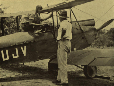
Image, Reverend Keith Langford-Smith and his Aeroplane, c1933, c1933
Two men and an aeroplanelangford-smith, aeroplane, missionary, arnham land, flight, sky pilot, pilot -
 Bendigo Historical Society Inc.
Administrative record - The Land Act 1869
The Victorian Parliament passed Land Acts in 1860, 1862 and 1869, which offered settlers land within defined agricultural areas. Settlers paid for half of an allotment on selection at a uniform price of £1 per acre and paid rent on the other half for usually 7 years. By the end of the period, to obtain title to the land, settlers would have had to pay the balance of the purchase price and make certain improvements. (from Wikipedia)Blue book missing front cover, some loose pages. The book contains amendments to the land act 1869. throughout the book there are handwritten notes with names and localitiesRed pen mark at the front Land(?) 869. some of the nameswriten are: Sanderson, O'Brien, H. Jackson, R. Wharton, W. Porter, J. Stewart, Foley and Mortonland act, victorian legislation -
 Surrey Hills Historical Society Collection
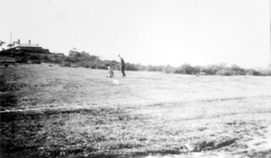
Photograph, Land in Everton Grove, Surrey Hills in 1927, 1927
The vacant land was the site of Norman Carter's future home at 21 Everton Grove. Norman Broadley Carter (1899-1984) married Mabel Annie Moore in 1927. Norman was an engineer with a passion for photography. Norman took many photos of Surrey Hills and Mont Albert from the 1920s and particularly of events and activities of the Church of England. For many years the house on the left located at 14 Harding Street belonged to the Kenneth Rothwell Culliton and his wife (Fanny) Molly Culliton. The house is located next to the Harding Street Reserve. Ken was an engineer and Molly was an early member of the Surrey Hills Historical Society. Ken was born and died in Surrey Hills. His father Harry Culliton was a well known golfer. His mother Christina Mary Rothwell was the daughter of Thomas Talbot Rothwell, known as a tea merchant and importer; also lived in Surrey Hills. This image is significant for its documentation of pre-urban Surrey Hills.Black and white photo of an area of gently sloping mown grass. On the horizon is a line of trees and on the LHS the outline of a (?) Victorian house can be seen. A man and a young boy are playing in the open space.everton grove, harding street, kenneth rothwell culliton, miss fanny molly arthur, mrs fanny molly culliton, norman broadley carter, mabel annie moore, mabel annie carter -
 Kew Historical Society Inc
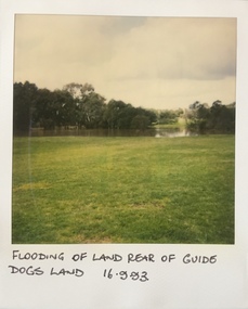
Photograph - Flooding at parkland at rear of Guide Dogs Victoria, 1993
The land currently occupied by Guide Dogs Victoria was once part of the grounds of the Kew Lunatic Asylum. This includes the land, designated as parkland which adjoins the Yarra River. It is now designated as the Chandler Park.Original colour small format polaroid photograph of flooding in parkland at the rear of Guide Dogs Victoria in the area now used as the Main Yarra Trail; taken on 16 September 1993."Flooding of land rear of Guide Dogs land 16.9.93"yarra river -- floods -- kew (vic.), guide dogs victoria, main yarra trail, chandler park -
 Bendigo Historical Society Inc.
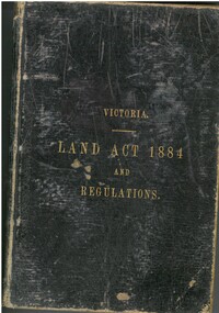
Book - VICTORIA LAND ACT 1884 AND REGULATIONS, 1885
Victoria Land Act 1884 with the Regulations Thereunder, 161 pages published Melbourne by the authority of John.Ferres, Government Printer 1885. Printed inside cover, Land Officer James Stirling Omeo 1.7.85victoria, history, land, victoria-history-land acts -
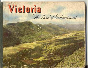 Ballarat Tramway Museum
Book, Nu-color-vue or Nucolorvue Productions, "Victoria The Land of Enchantment", c1950
Book with hardcovers, 48 pages titled "Victoria The Land of Enchantment". Sewn in three sections, with a green strip of cloth and self end papers and printed outer paper, sides glued onto board covers. Consists of 43 colour photographs (full and half page) with captions, detailed text, and two black and white photos printed in blue on end covers. Photos of Mt Buffalo, Gippsland lakes, Mornington Beach, Yarra River, Flinders St. station from the Yarra, Collins and Spring St (with two W2's - see image No. 2), Parliament House, Kiewa Hydro scheme, Eildon Weir, Swan Hill Murray River Bridge, Bendigo Post Office, Melbourne Botanical Gardens, Ballarat - Grenville and Sturt St (No. 22 - see image No. 3), Lorne, Yallourn Power Station, Hume Weir, Maroondah Weir, Great Ocean Road, Warrnambool, Portland Beach, A timber train (see image No. 4), Mildura, flax mills, Eastern Geelong and the Prime Ministers Ave, Ballarat. Produced by Nucolorvue Productions, c1950. See also Reg Item 2925 for the same photo of No. 22 and Reg Item 5354 for a postcard. Purchased via eBay site - see attached sheets and packing slip. Purchased 10/2/2005 for A$12.50 including postage, from Virginia Georgopoulos of West Brunswick. eBay sheets and envelope with worksheet file. Has Swains 123 Pitt St, Sydney sticker on bottom left hand corner page 2trams, tramways, ballarat, sturt st, grenville st, bogie trams, geelong, bendigo, melbourne -
 Bendigo Historical Society Inc.
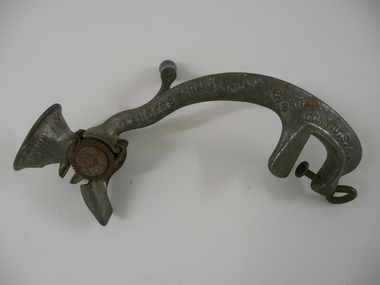
Tool - FOOD MINCER
Cast iron food mincer for seeding raisins, with handle & screw attachment for securing to bench or table, black wooden handle. Marked Landers Frary & Clark New Britain Conn. USA. Pat Nov 24.96 Wet the Raisins No 4 Crown.Landers Frary & Clarkdomestic equipment, food preparation, raisin seeder, k195 -
 Dandenong/Cranbourne RSL Sub Branch
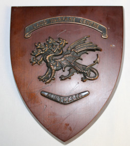
Land Warfare Centre plaque
Shield shaped plaque made on a red varnished wood with a copper badge of a seven headed dragon affixed to the centre above the dragon is a banner with " Land Warfare Centre" and below it is a boomerang pointed down with "Australia" on inLand Warfare Centre--- Australia -
 Ringwood and District Historical Society
Newspaper Cutting, The Sun, Ringwood Development article (Sun Newspaper) 23 Aug 1960, 23-Aug-60
Article about land 'frieze' of the 16 acres of land for the proposed development site for Eastland.Article about Ringwood development in Sun newspaper. Double page. +Additional Keywords: Lavis, A.G., Mayor / Dwerryhouse, F.P., Town ClerkLand 'Frieze' at Ringwood. -
 Ringwood and District Historical Society
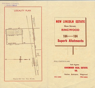
Document - Folder, Land Sale Brochure, New Lincoln Estate, Ringwood, Vic. - circa 1960. Also 1951 newspaper advertisement
Bi-fold advertisement for sale of residential allotments - New Lincoln Estate, New Street, Ringwood, with summary of local facilities and services, locality plan, layout of sub-division, and price list. Also an advertisement from Ringwood Mail dated 12 July 1951. Subdivision includes New Street, Heywood Street, Barkly Street, Keith Grove, Maurice Avenue, Inez Avenue, Catherine Street, Neville Street, Neale Grove (later Heather Grove), and Sylvia Grove. Agent - Ringwood Real Estate Co., Station Entrance, Ringwood. (Phone) WU 6661, WU 6662.Accompanying handwritten sales notes researched in 2024 by Richard Carter - Carter Real Estate ... "Maurice Ashkanasy KC CMG owned the rectangular estate located between New, Barkly, Heywood Streets and Sylvia Grove in South-West Ringwood. It was given the name "The New Lincoln Estate". It was first advertised around July 1951 as "48 superb allotments", through Ringwood Real Estate (Station Entrance). A sub-divisional plan from CE Carter showed 152 blocks with 60-foot frontages and varying between 110 and 150 feet in length. Later, in 1954 house and land packages were offered through William White in Elsternwick - "Three modern bedrooms, large lounge-dining-room, kitchen with dinette, nicely equipped bathroom - £2,685 to £2,762, deposit £300". The roads were created and named after family members - Neale (later Heather) Grove - after Maurice's son Neal Mark Ashkanasy. The street was later re-named Heather Grove after Maurice's wife, Heather Helen Ashkanasy (Epstein), who passed away in 1999, aged 95. Neville Street - after Marice's other son, Aaron Solomon Neville Ashkanasy known as Neville. Catherine Street and Inez Street - after Heather's mother Catherine Inez Epstein. Maurice Avenue - after Maurice Ashkanasy, vendor. Keith Grove - after Keith Epstein. ..." -
 Melton City Libraries
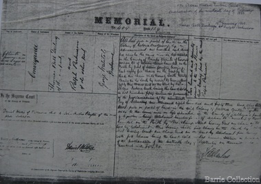
Document, Darlingsford land title, 1863
Thomas Bell Darling purchased 176 acres from the Toolern Creek to Ferris Road. A house and bluestone barn/stables were built. The property was owned by Ralph Parkinson, followed by Richard Manning. SUMMARY – Darlingsford – Auction 1910 Darlingsford – Auction 1910 Melton Express October FRIDAY, October 28th At Three O’Clock At the RAGLAN HOTEL, MELTON SUBDIVISIONAL SALE of the DARLINGSFORD ESTATE, MELTON. Having a long frontage to the TOOLERN CREEK. In the Estate of the late RICHARD MANNING’ W. S. KEAST and L.A. FAIRBAIRN & CO., Auctioneers (in conjunction). Have received instructions from R.F. and J.L. Robertson, executors of Richard Manning deceased to offer by Public Auction, property almost adjoining Melton township, and having a frontage to the Toolern Creek, subdivided in to four lots as under:- Lot 1. – The homestead block containing 176 acres, being portion A, section 11, parish Kororoit together with the improvements, which consist of a 6-roomed stone house, milking shed, dairy, U.G. tank. Lot 2 – 177 acres 2 rood 23 perches, being Crown portion B of section 11 parish Kororoit. This block adjoins the homestead and is partly fenced. Lot 3 – 187 acres, Crown allotment C, section 11, parish Kororoit. adjoining the above lot. Lot 4 - 157 acres 1 rood 27 perches, being Crown allotment 9, section 12, parish of Kororoit. This block is only divided from the above lots by road, and adjoining Messrs. McVean and Gaitskill’s properties. This is one of the best known properties in the Melton district as a cultivation an grazing form, and its close proximity to the township makes it a very valuable, and portion of which could be cut into township blocks and should command a ready sale. For absolute sale. Terms- one fifth cash, one fifth in eight years, balance in 7 years with interest a the rate of 4 1/2 percent. Plan on application For further particulars apply W.S. KEAST, 610 Collins street, Melbourne; and L.A. FAIRBAIRN & Co., St James-buildings, Williams street, or at Bacchus Marsh; and as to the title, Dugdale and Creber, St. James-buildings, William Street Melbourne. Express November 5, 1910 On Friday last, Mr W.S. Keast and Messrs L.A. Fairbairn & Co., in conjunction, offered at the Raglan the Manning Estate known as Darlingsford, comprising of 700 acres, divided into four lots. Lot 4 was submitted first and passed in at L8 per acre. Lot 1 was then put up and went up to L13 per acre, at which it was also passed in. Lot 3 was next offered, and there being no bid was also passed in. Lot 2 was not offered. Express March 18, 1911 The Manning Estate of Darlingsford 600 acres was sold to Mr. Ernie for an undisclosed price. Note: Map KOROROIT COUNTY OF BOURKE Crown Grant Section 11 Portion A Thomas. B. Darling 176 . 0 . 0 acres on 29.3.1853 Lot 1 Portion B A. Russell 170 . 0 . 0 acres on 29.3.1853 Lot 2 Portion C Peter Inglis 176 . 0 . 0 acres on 29.3.1853 Lot 3 Section 12 Portion 3 P. Inglis 157 . 1 . 27 acres on 17.17.1863 Total 176 170 176 157. 1.27 679 . 1.27 acres November 5th 1910 On Friday night last Mr W S Keast and Messrs L A Fairbairn & Co, in conjunction offered at the Raglan Hotel the Manning Estate known as Darlingsford, comprising of 700 acres, divided into four Lots. Lot 4 was submitted first, and was passed in at L8.0.0. per acre. Lot 1 was then put up and went to L13.0.0. per acre at which it was passed in. Lot 3 was next offered, and then Lot 3 was next offered, and then being no bid was passed in. Lot 2 was not offered. October 22nd Notice of sale. 700 acres of splendid land close to the railway station. Divided onto 4 Lots 3 of which are maiden land and the whole of the acres is chocolate soil. No 1 Lot belonged to the late Mr Ralph Parkinson, and for years was liberally supplied with manure and crushed bones, and is capable of producing many crops.. The property being sold to wind up the Estate. Gisborne Gazette Friday December 17th 1911 Mr Sharp has sold his farm at the back of the township to Mr. E Barrie; price L15/10/ per acre. Agreement between Thomas Bell Darling and Ralph Parkinsonlocal identities -
 Eltham District Historical Society Inc
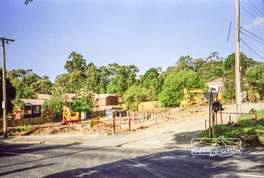
Photograph, Clearing land for Le Pine Funeral Home, cnr York Street and Main Road, Eltham, c.March 1998, 1998
Newsletter No. 116, September, 1997 846-848 MAIN ROAD ELTHAM Nillumbik Shire Council has granted a permit for a funeral parlour on land which includes this site at the corner of Main Road and York Street. The site contains an architect's office in a building which was formerly a shop and dwelling dating from the 1920's. The proposal requires demolition of this building which is one of the few remaining old shops which formed the rather spread out "town centre" of Eltham. Prior to making its decision the Council obtained a report from Graeme Butler and Associates, the heritage consultants who carried out Stage 1 of the Nillumbik Heritage Study. The report summarized the historical significance as follows:- "This brick comer shop with associated residence has potential local historical significance as a late 1920's grocer's shop, now much altered and one of only a few shops of that era left in Eltham's Main Road. This significance is qualified by the many changes. The other examples are better preserved and still function as shops." With this type of expert advice it is difficult to make a strong case for preservation of the building although, of course, it is a shame to see it demolished. The report includes details of the site itself and its history based on research carried out by Carlotta Kellaway. The building dates from the late 1920's when it was owned by C.R. Nicholls. From the early 1930's it was Charles Cockroft's grocery shop and he also ran a grain store there. According to his daughter, Edna Brown, he delivered groceries around the district taking his truck as far as Kangaroo Ground. In 1950 he shifted to Traralgon. Since then several different businesses have operated from the site including a bottle merchant and produce store. Conversion to the present office use involved alterations to the shop front and rebuilding the galvanized iron store at the rear. Newsletter 119 March 1998 In our Newsletter No. 116 it was reported that the former shop on the comer of Main Road and York Street, Eltham was to be demolished as part of a funeral parlour development. If you have passed the site recently you will have noticed that it has now been demolished - another part of the old Eltham township has disappeared.Roll of 35mm colour negative film, 6 strips Also photographic prints 10 x 15 cmKodak Gold 200-6a.r. warren, eltham feed store, le pine funeral home, main road, york street, c.r. nicholls, charles cockcroft, grocery store -
 Eltham District Historical Society Inc
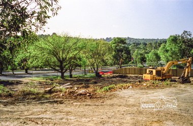
Photograph, Clearing land for Le Pine Funeral Home, cnr York Street and Main Road, Eltham, c.March 1998, 1998
Newsletter No. 116, September, 1997 846-848 MAIN ROAD ELTHAM Nillumbik Shire Council has granted a permit for a funeral parlour on land which includes this site at the corner of Main Road and York Street. The site contains an architect's office in a building which was formerly a shop and dwelling dating from the 1920's. The proposal requires demolition of this building which is one of the few remaining old shops which formed the rather spread out "town centre" of Eltham. Prior to making its decision the Council obtained a report from Graeme Butler and Associates, the heritage consultants who carried out Stage 1 of the Nillumbik Heritage Study. The report summarized the historical significance as follows:- "This brick comer shop with associated residence has potential local historical significance as a late 1920's grocer's shop, now much altered and one of only a few shops of that era left in Eltham's Main Road. This significance is qualified by the many changes. The other examples are better preserved and still function as shops." With this type of expert advice it is difficult to make a strong case for preservation of the building although, of course, it is a shame to see it demolished. The report includes details of the site itself and its history based on research carried out by Carlotta Kellaway. The building dates from the late 1920's when it was owned by C.R. Nicholls. From the early 1930's it was Charles Cockroft's grocery shop and he also ran a grain store there. According to his daughter, Edna Brown, he delivered groceries around the district taking his truck as far as Kangaroo Ground. In 1950 he shifted to Traralgon. Since then several different businesses have operated from the site including a bottle merchant and produce store. Conversion to the present office use involved alterations to the shop front and rebuilding the galvanized iron store at the rear. Newsletter 119 March 1998 In our Newsletter No. 116 it was reported that the former shop on the comer of Main Road and York Street, Eltham was to be demolished as part of a funeral parlour development. If you have passed the site recently you will have noticed that it has now been demolished - another part of the old Eltham township has disappeared.Roll of 35mm colour negative film, 6 strips Also photographic prints 10 x 15 cmKodak Gold 200-6a.r. warren, eltham feed store, le pine funeral home, main road, york street, c.r. nicholls, charles cockcroft, grocery store -
 Eltham District Historical Society Inc
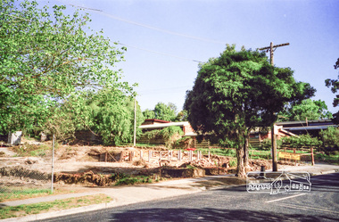
Photograph, Clearing land for Le Pine Funeral Home, cnr York Street and Main Road, Eltham, c.March 1998, 1998
Newsletter No. 116, September, 1997 846-848 MAIN ROAD ELTHAM Nillumbik Shire Council has granted a permit for a funeral parlour on land which includes this site at the corner of Main Road and York Street. The site contains an architect's office in a building which was formerly a shop and dwelling dating from the 1920's. The proposal requires demolition of this building which is one of the few remaining old shops which formed the rather spread out "town centre" of Eltham. Prior to making its decision the Council obtained a report from Graeme Butler and Associates, the heritage consultants who carried out Stage 1 of the Nillumbik Heritage Study. The report summarized the historical significance as follows:- "This brick comer shop with associated residence has potential local historical significance as a late 1920's grocer's shop, now much altered and one of only a few shops of that era left in Eltham's Main Road. This significance is qualified by the many changes. The other examples are better preserved and still function as shops." With this type of expert advice it is difficult to make a strong case for preservation of the building although, of course, it is a shame to see it demolished. The report includes details of the site itself and its history based on research carried out by Carlotta Kellaway. The building dates from the late 1920's when it was owned by C.R. Nicholls. From the early 1930's it was Charles Cockroft's grocery shop and he also ran a grain store there. According to his daughter, Edna Brown, he delivered groceries around the district taking his truck as far as Kangaroo Ground. In 1950 he shifted to Traralgon. Since then several different businesses have operated from the site including a bottle merchant and produce store. Conversion to the present office use involved alterations to the shop front and rebuilding the galvanized iron store at the rear. Newsletter 119 March 1998 In our Newsletter No. 116 it was reported that the former shop on the comer of Main Road and York Street, Eltham was to be demolished as part of a funeral parlour development. If you have passed the site recently you will have noticed that it has now been demolished - another part of the old Eltham township has disappeared.Roll of 35mm colour negative film, 6 strips Also photographic prints 10 x 15 cmKodak Gold 200-6a.r. warren, eltham feed store, le pine funeral home, main road, york street, c.r. nicholls, charles cockcroft, grocery store -
Bendigo Historical Society Inc.
Book - REPORT ON THE NORTH CENTRAL STUDY AREA OF VICTORIA
252 page Report on the North Central Study Area by the Land Conservation Council of Victoria - July 1978 Illustrated with B&W photos Back section contains several removeable maps. Printed by F D Atkinson, Government Printer, MelbourneLand Conservation Council, Victoria -
 Eltham District Historical Society Inc
Ledger, Eltham Road District. Assessment for the Year ending Oct. 14th, 1859, 1858c
The Eltham Roads Board was established in 1856. This ledger includes the signature of Road Board Secretary and Collector Wingrove, a significant person in Eltham's early history. This is a unique significant record of early settlers in the Shire of Eltham. One of 6 early rate books. This is among the oldest items in the EDHS collection. An article in the Eltham and Whittlesea Shires Advertiser Friday 21 Nov 1941 Page 5 titled: District's Early History states: "The first rate book which is still in existence at the Shire Office is for the year ending October 14, 1858 and is probably the best record possible to indicate the development of the district. At the time properties were rated as follows: Cultivated land. 6d. per acre; pasture land, 1d. per acre: estimated annual value of buildings, etc., 6d in the (pound). The total amount of rate recorded for the year was (pounds)153/14/8. Properties were described as being situated at Lower Plenty, Yarra Yarra, Eltham, Lower Eltham, Kangaroo Ground, Yarra Flats, Diamond Creek and the Yarra."Ledger with printed columns: Number, Name of Occupier, Description, Where situated, Cultivated land, Pasture land, Estimated annual value of buildings, Rate, Remarks, Arrears collected, excused, unoccupied, uncollected and amount actually collected. Ledger filled out by hand with 173 entries (not alphabetically arranged). A number of blank pages are included. Inside cover includes pasted printed note: RATE OF ASSESSMENT AS FOLLOWS: Cultivated land 6d per acre Pasture land 2d per acre Unalienated Pasture Land 8d per Acre Estimated Annual Value of Buildings, &c., 6d. in the Pound eltham roads board, rate book, rate payers, transaction, pioneers, settlers, wingrove, 1859, assessment ledger, eltham road district, public records office victoria (prov), rate books, shire of eltham archives -
 Eltham District Historical Society Inc
Ledger, Eltham Road District. Assessment for the Year ending Oct. 14th, 1860 (Version 1), 1859c
The Eltham Roads Board was established in 1856. This is a unique significant record of early settlers in the Shire of Eltham. One of 6 early rate books. This is among the oldest items in the EDHS collection. An article in the Eltham and Whittlesea Shires Advertiser Friday 21 Nov 1941 Page 5 titled: District's Early History states: "The first rate book which is still in existence at the Shire Office is for the year ending October 14, 1858 and is probably the best record possible to indicate the development of the district. At the time properties were rated as follows: Cultivated land. 6d. per acre; pasture land, 1d. per acre: estimated annual value of buildings, etc., 6d in the (pound). The total amount of rate recorded for the year was (pounds)153/14/8. Properties were described as being situated at Lower Plenty, Yarra Yarra, Eltham, Lower Eltham, Kangaroo Ground, Yarra Flats, Diamond Creek and the Yarra."Ledger with printed columns: Number, Name of Occupier, Description, Where situated, Cultivated land, Pasture land, Estimated annual value of buildings, Rate, Remarks, Arrears collected, excused, unoccupied, uncollected and amount actually collected. Ledger filled out by hand with 177 entries (not alphabetically arranged). A number of blank pages are included. Inside cover includes pasted printed note: RATE OF ASSESSMENT AS FOLLOWS: Cultivated land 6d per acre Pasture land 2d per acre Unalienated Pasture Land 8d per Acre Estimated Annual Value of Buildings, &c., 6d. in the Pound eltham roads board, rate book, rate payers, transaction, pioneers, settlers, wingrove, 1860, assessment ledger, eltham road district, public records office victoria (prov), rate books, shire of eltham archives -
 Eltham District Historical Society Inc
Ledger, Eltham Road District. Assessment for the Year ending Oct. 14th, 1861, 1860c
The Eltham Roads Board was established in 1856. This is a unique significant record of early settlers in the Shire of Eltham. One of 6 early rate books. This is among the oldest items in the EDHS collection. An article in the Eltham and Whittlesea Shires Advertiser Friday 21 Nov 1941 Page 5 titled: District's Early History states: "The first rate book which is still in existence at the Shire Office is for the year ending October 14, 1858 and is probably the best record possible to indicate the development of the district. At the time properties were rated as follows: Cultivated land. 6d. per acre; pasture land, 1d. per acre: estimated annual value of buildings, etc., 6d in the (pound). The total amount of rate recorded for the year was (pounds)153/14/8. Properties were described as being situated at Lower Plenty, Yarra Yarra, Eltham, Lower Eltham, Kangaroo Ground, Yarra Flats, Diamond Creek and the Yarra."Ledger with printed columns: Number, Name of Occupier, Description, Where situated, Cultivated land, Pasture land, Estimated annual value of buildings, Rate, Remarks, Arrears collected, excused, unoccupied, uncollected and amount actually collected. Ledger filled out by hand with 185 entries (not alphabetically arranged) and summary section. A number of blank pages are included. Inside cover includes pasted printed note: RATE OF ASSESSMENT AS FOLLOWS: Cultivated land 6d per acre Pasture land 2d per acre Unalienated Pasture Land 8d per Acre Estimated Annual Value of Buildings, &c., 6d. in the Pound eltham roads board, rate book, rate payers, transaction, pioneers, settlers, 1861, assessment ledger, eltham road district, public records office victoria (prov), rate books, shire of eltham archives -
 Bendigo Historical Society Inc.
Document - PRINTED NOTE PAD FOR LAND VALUATION
Note pad. Eleven blank land valuation worksheets for the Land Commission. Each valuation comprises 3 separate pages to record Lessee's and Commission's improvements plus stock, implements and other assets. Some of these pages have been used to record other items not related to the above. Handwritten in ink as follows. (1) Royal Historical Society of Victoria - notes on general index codes. (2) Snobs Hill Rovers football club 1904 - some 50 names. (3) Officers and members of the Hopetoun Brass Band, Bendigo as at 14 Feb 1913 - Name No.473 is Sir John Quick. Name No. 497 is J. Michell, bandmaster. Ends at Name No.522. (4) Eaglehawk Pioneers - Name nos.523 to 618. Each name has a year beside it ranging from 1846 ? (J.Mouatt) to 1863. (5) One page list of Regional Parishes each with a date and number, (crossed out in pencil).Land Commission ?government, state, land commission, valuation notepad, snobs hill rovers football club, hopetoun brass band, eaglehawk pioneers, regional parishes, index codes for royal historical society of victoria -
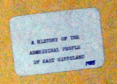 Orbost & District Historical Society
Document - File Folder, A History of Aboriginal People of East Gippsland, January 1985
This item is a useful reference tool on the history of Indigenous People in East Gippsland and the Orbost district. A manilla folder with typed pages. On the cover is a label, "History of Aboriginal People of East Gippsland". On the inside cover is a letter addressed to the librarian at the Shire of Orbost Library. The letter is clipped to the inside of the folder.on front cover - a stamp -"Orbost Historical Society"aboriginal australians, gippsland aboriginal history, kurnai, brabawooloong peoples, tatungooloong peoples, krowathunkooloong peoples -
![Book - Map, Land Conservation Council, Melbourne Study Area Report, [December 1973]](/media/collectors/4f729f7b97f83e03086018a5/items/6469bc241d76dd4b008a829f/item-media/646b0013d841f8920fa4323c/item-fit-380x285.jpg) Eltham District Historical Society Inc
Eltham District Historical Society IncBook - Map, Land Conservation Council, Melbourne Study Area Report, [December 1973]
The Melbourne Study Report is a series of volumes describing the physical nature of the land and its environment, examines the likely forms of land use, and assesses the hazards associated with these uses. This is Volume 2 (coloured maps). The first page featues a black and white map described as "Shire of Diamond Valley" with public land marked in yellow. Followed by eight large fold out maps. Melbourne Study Area Public land and descriptive blocks, Population description, Geology, Physiography, topography and rainfall, vegetation and water supply. The Land Conservation Act 1970 established the Land Conservation Council whose functions is to "carry out investigations and make recommendations to the Minister with respect to the use of public land in order to provide for the balanced use of land in Victoria. This report sets out to describe and assess the natural resources of the public lands in the Melbourne area and provides a factual basis on which members of the community may base submissions to the [Land Conservation] Council of Victoria.A collection of eight large fold out coloured maps published in a bound book formnon-fictionThe Melbourne Study Report is a series of volumes describing the physical nature of the land and its environment, examines the likely forms of land use, and assesses the hazards associated with these uses. This is Volume 2 (coloured maps). The first page featues a black and white map described as "Shire of Diamond Valley" with public land marked in yellow. Followed by eight large fold out maps. Melbourne Study Area Public land and descriptive blocks, Population description, Geology, Physiography, topography and rainfall, vegetation and water supply. The Land Conservation Act 1970 established the Land Conservation Council whose functions is to "carry out investigations and make recommendations to the Minister with respect to the use of public land in order to provide for the balanced use of land in Victoria. This report sets out to describe and assess the natural resources of the public lands in the Melbourne area and provides a factual basis on which members of the community may base submissions to the [Land Conservation] Council of Victoria. maps, shire of diamond valley, population, geology, topography, rainfall, vegetation, water supply, land use, public lands -
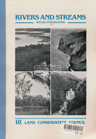 Eltham District Historical Society Inc
Book, Land Conservation Council, Rivers and Streams: Special Investigation, September 1989
In June 1987, the government directed the LCC to carry out a special investigation of the social, recreational, cultural and ecological values of rivers and streams in Victoria, and to make recommendations on the use of these rivers and how their identified values can best be protected. Notices announcing the commencement of the investigation were published in the Victoria Government Gazette and in Victorian newspapers in November 1987. A descriptive report was published in September 1989. The Council received 75 submissions following the publication of this report. After considering these submissions, the Council formulated its proposed recommendations, which were published in November 1990. The Council received 177 submissions commenting on the proposed recommendations. The Council published its final recommendations in June 1991. While welcomed by many, the study cut across the interests of other groups and was perceived to be particularly threatening to water authorities. The investigation resulted in a legislated system of 17 heritage rivers (with significant natural, recreational, scenic and heritage values) and natural catchment areas across Victoria. -
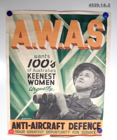 Bendigo Military Museum
Poster - RECRUITMENT POSTER WW2
See also Cat. No. 4530.4Paper recruitment poster. There is a photo of a female in uniform and helmet holding a pair of binoculars, looking skywards.wwii, awas, recruitment -
 Bendigo Military Museum
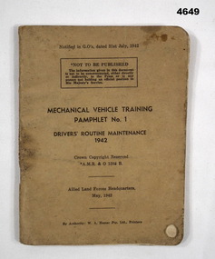
Pamphlet - PAMPHLET, MECHANICAL, Allied Land headquarters, May 1942
Alan Mason collection, refer cat No 3979.2Pamphlet “mechanical vehicle Training, brown covers, all print in black, 60 pages with all print in blackOn front,”Drivers Routine Maintenance 1942”mechanical, pamphlet, driver training -
 Federation University Historical Collection
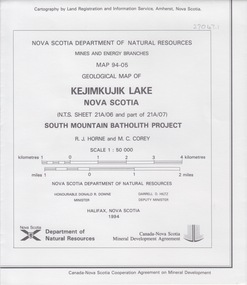
Map - Geological, Nova Scotia Department of Natural Resources, Kejimkujik Lake, Nova Scotia: Geological Map 94-05, 1994
Produced b Nova Scotia Department of Natural Resources, Mines and Energy Branches. The Minister of the Department was the Honourable Donald R Downe and the Deputy Minister was Darrell D HiltzLarge coloured map depicting different areas and deposits. Includes a legend, symbols used, mineral abbreviations and alteration abbreviations.Symbolsnova scotia, kejimkujik lake, geological survey, cartography, mine and energy branches, donald r downe, minister, darrell d hiltz, deputy mnister, south mountain batholith project, legend, symbols -
 Federation University Historical Collection
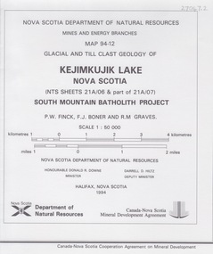
Map - Geological, Kejimkujik Lake, Nova Scotia: Glacial and Till Clast Geology: Map 94-12, 1994
Produced b Nova Scotia Department of Natural Resources, Mines and Energy Branches. The Minister of the Department was the Honourable Donald R Downe and the Deputy Minister was Darrell D HiltzLarge coloured map depicting different areas and deposits. Includes a legend, symbols used, mineral abbreviations and alteration abbreviations.Symbols -
 Federation University Historical Collection
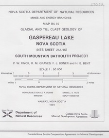
Map - Geological, Gaspereau Lake, Nova Scotia: Glacial and Till Clast Geology: Map 94-14, 1994
Produced by Nova Scotia Department of Natural Resources, Mines and Energy Branches. The Minister of the Department was the Honourable Donald R Downe and the Deputy Minister was Darrell D HiltzLarge coloured map depicting different areas and deposits. Includes a legend, symbols used, mineral abbreviations and alteration abbreviations.Symbolsnova scotia, department of natural resources, mines and energy branch, donald r downe, minister, darrel d hiltz, deputy minister, glacial and till clast, geo;logy, south mountain batholith project