Showing 3262 items
matching name buildings
-
 Warrnambool and District Historical Society Inc.
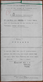
Document, Thomas Smith Probate 1880
Tait collection: item 33 of 62 This probate document gives details of the will of Thomas Smith, a farmer in the Wangoom district who was a pioneer settler, having arrived in the area about 1848. He erected the Shamrock Hotel in Dennington in 1868 and it was opened for business in 1869 with David Duffy as the first licensee. Thomas Smith was the licensee in 1870 and members of his family (Cornelius, Robert and Mary Smith) held the licence of the hotel until 1880. A codicil to the will gave Mary Smith, Thomas’ daughter, the hotel land and building. This hotel closed in 2011. Thomas Smith signed the original will with a cross (his mark). Other names mentioned in the probate document are Frederick Wilkinson, Master-in-Equity, Ernest Chambers, Solicitor, John Drayton, Clerk to E. Chambers, William Ardlie, Senior, Solicitor, Thomas Goodall, Clerk to William Ardlie, Richard Sheldrick, Clerk to William Ardlie, Walter Davies, Stationer.This is a significant document as Thomas Smith was a prominent owner of land, especially in the Dennington area. The Shamrock Hotel in Dennington was built by Smith and still owned by him when he died in 1880. The will gives important details of the estate of Thomas Smith and adds to our knowledge of his life and work. Document – Probate, 1880/1907 - the Will and Codicil of Thomas Smith, Farmer of Dennington The will has six ruled paper pages of typewritten material. Each page has printed ruled red lines top, bottom and sides and all are tied with green corded string. There are handwritten corrections and signatures, including those of Ernest Chambers, Solicitor of Warrnambool and John Drayton, Clerk to E. Chambers.Thomas Smith Shamrock Hotel, Dennington Ernest Chambers, Solicitor thomas smith wangoom 1848, shamrock hotel dennington, warrnambool history, thomas smith 1880 -
 Warrnambool and District Historical Society Inc.
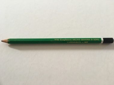
Artefact, Archie Graham & Son Warrnambool - 4423, Mid 20th century
This pencil was used as an advertising medium for the Warrnambool firm of Archie Graham and Sons. It was given to customers of the firm. Archie Graham (1906-1992) commenced a building business in Warrnambool in the 1930s and was well-known for his many building projects in the city and his innovation in the industry. Archie Graham was a prominent member of the Uniting Church and a tireless worker in community affairs in Warrnambool for sixty years. He planned and organized the street decorations for the Warrnambool Centenary in 1947, was chairman of the committee that developed Albert Park and the Reid Oval and was active in Rotary Club and Cricket Club affairs. He was also a member of the Warrnambool Technical School Council. Today the building in Timor Street for senior citizens and other community use is named after Archie Graham. This pencil is of interest as a memento of the type of complimentary article given to customers of businesses in Warrnambool in the mid 20th century. It is also a memento of Archie Graham, an important businessman and community worker in Warrnambool in the 20th century. This is a large six-sided wooden pencil sharpened at one end. The pencil is painted green with a white band near the top and a black-colored end rounded at the top. The paint on the pencil is slightly chipped. The inside of the pencil contains graphite for writing or drawing. The business name on the side of the pencil is inscribed in gold lettering. ‘With Compliments ARCHIE GRAHAM & SONS WARRNAMBOOL – 4422’ archie graham, warrnambool, history of warrnambool -
 Warrnambool and District Historical Society Inc.
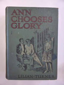
Book, Ann Chooses Glory, 1928
This book was given in 1929 to Alma McCullagh by the Dennington Sabbath (Sunday) School with the teacher being R. Conn. The Dennington Presbyterian Church was originally established in Drummond Street in 1918. In 1951 it was moved to Lindsay Street and demolished in 1968. R. Conn may be Ruby Conn who was born in Warrnambool in 1890 to Joseph and Ann Conn. Joseph Conn was a blacksmith from Illowa in the late 19th century (today in that area we have Conn’s Corner and Conn’s Lane). The McCullagh family had a property in Yangery named Oak Grove.This book is of interest because of the 1920s connection to the Dennington Presbyterian Church, the Conn family and the McCullagh families.This is a hard cover book of 256 pages. The cover is green with red and black lettering and an image of two men and two women inside a building. The cover is torn away on the back right hand corner. There are five full page black and white illustrations scattered throughout the text. The inscriptions are handwritten in black ink. There is a stamp of a lion on the first page.‘Presbyterian Sabbath School Dennington, Prize awarded to Alma McCullagh, January 1929, R. Conn, Teacher’ ‘Alma McCullagh Dennington’ ‘Alma McCullagh’ alma mccullagh, joseph conn, illowa, history of warrnambool -
 Warrnambool and District Historical Society Inc.
Book, Accounts 1898-1902, Early 19th century
This accounts book has been used by a Warrnambool butcher whose name is unknown. The entries date from 1913 to 1915 and the names of those with accounts are mostly well-known residents of Warrnambool at the time. The items bought include hams, shoulders, lard, sides, German sausage, pork sausages, bacon, hocks and bones. The book was found in the old Mackay Taylor law firm building and was obviously in storage with that firm. The owner of the accounts book would have been a client of the law firm. Mackay Taylor was formed in 1893 with the merger of the law firms of George Sutherland Mackay and James Fletcher, a business that was known originally as Fletcher and Mackay and then changed to Mackay and Taylor in the 1920s. The business was at 131 Kepler Street.This accounts book is of some interest as it contains the names of many prominent Warrnambool people and their meat-related purchases in the 1913-1915 time frame. These include the names Battarbee, Ward, Milvertion, Harrington, Murrell, Powell, Younger, Smith and Russell. The lists of items bought show the lifestyles and eating habits of the time with some bulk buying of large pieces of meat, some for hotels etc. This is a small maroon coloured bound book of 173 pages (double-sided). There are pages with alphabetical tabs at the start of the book. Inside the front and back covers are inserts of heavy quality paper with a blue and red design. The entries are written in black ink.On spine – ‘Ledger’warrnambool butcher, warrnambool -
 Warrnambool and District Historical Society Inc.
Book, Cash Book, Late 19th century
This cash book, found in the old Mackay Taylor building in Kepler Street, contains entries relating to Costs Accounts and Trust Accounts for the Warrnambool firm of Fletcher and Mackay which had been formed from the amalgamation of the law firms of George Mackay and James Fletcher in 1893. In the 1920s the firm became Mackay and Taylor after J. McD. Taylor became the partner with George Mackay. This firm was a prominent one in Warrnambool until the 1990s. This cash book is of considerable interest as the entries show the names of many well-known residents of Warrnambool at the end of the 19th century and the beginning of the 20th century. The firm of Fletcher and Mackay was an important one in Warrnambool at that time and George Mackay, one of the partners of the firm, was prominent in local community and civic affairs. This is a ledger with black binding and buff-coloured spine and corner reinforcements. There are 135 double-sided pages. The pages have been printed with red ruled lines for accounting purposes. There are red and blue mottled coloured cardboard pages at the beginning and end of the book. There are two loose pages which appear to be scrap notes only. The entries are written in black ink.White paper pasted on front cover: ‘Cash Book from April 26th 1898 to March 22nd 1902’ Spine: ‘1898-1902 Cash Book’ james fletcher and george mackay, warrnambool law firms, warrnambool -
 Warrnambool and District Historical Society Inc.
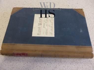
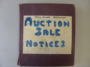
Book, Henry Jacobs Auctioneer: Auction Sale Notices, c1941
This scrapbook contains hundreds of auction sale notices for Warrnambool properties (and some more distant) dating from September 1941 to March 1972. In some instances the newspaper article noting the details of the sale and articles recording the result of the sale are included. The names of many of the real estate firms of the period form part of the advertisement. It provides a significant research tool relating to properties in Warrnambool and information to interpret the type of buildings available during this period. The firm of Henry J. Jacobs & Son, Auctioneers & Real Estate Agents was located at 146a Liebig Street with the known dates 1937 to 1964, and at 81 Liebig Street from the 1960s. Henry Jacobs' Frank Jacobs, also worked in the business. This book has been indexed in Houses and Properties Index.This scrapbook is of considerable local significance as it gives a great deal of information on people, properties, prices and sales in the timeframe (19401-1972). It is invaluable to researchers as it contains not only the details of the auctions at the time but also extra information on the owners and buyers and sellers, the names of the properties, the frequency of sales of properties of the time and the names of estate agents operating during the period. It has social significance in that it shows one manner in which business collated information.Dark red cloth bound scrapbook with brown paper pages. The front has a zig-zag imprint as a border and a paper label noting the title of the volume in blue and black text with red underlining. Inside the book has newspaper notices for auction sales from various Warrnambool real estate agents. The last pages are empty.Henry Jacobs - Auctioneer/ AUCTION/SALE/NOTICEShenry jacobs auctioneer, auctioneers, real estate agents, warrnambool, auction sales, jacobs, frank -
 Warrnambool and District Historical Society Inc.
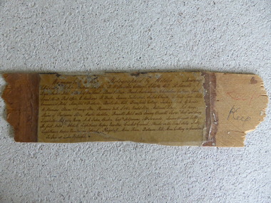
Frame Fragment, Frame Fragment from 1860 J Wilder, Late 19th century
Joseph Wilder, a professional photographer, came to Warrnambool in 1860 and took a series of photographs, two of which survive today. One was of the local Volunteer Corps and the other was a series of photographs taken from Cannon Hill showing Merri Street and the town and buildings beyond. It seems that copies of these last-mentioned photographs were framed to produce a large panoramic view of 1860 Warrnambool and one of these was given to the old Warrnambool Museum in the 1880s by James Astley Bromfield. He had established a chemist’s shop in Warrnambool in 1854 and showed his interest in the history of the young town by producing a map in 1856 showing the first landowners, a seminal resource today for historians. He again demonstrated this interest when he included the names of the people and places in the 1860 photograph he gave to the museum in the 1880s. The frame fragment was found amongst the collection of items from the old Museum at Flagstaff Hill Maritime Museum and brought to the Historical Society to accompany the original series of photographs. Bromfield went to live in Melbourne in the 1880s. It is presumed that the plastic cover has been placed on the frame fragment at a much later date than the 1880s.This frame fragment is interesting and very important for several reasons:- 1. It is one demonstration of the interest that James Astley Bromfield had in local history 2. It came from the old Warrnambool Museum and shows how that institution kept items of historical interest 3. It gives us the names of the people and places in the Joseph Wilder photographs of 1860 that placed together form a panorama that reveals what a major section of Warrnambool looked like only 13 years after its foundation. The list enables us to correctly identify the early places and people and so is invaluable for research purposes 4. It links a Museum exhibit of the 1880s with the original 1860 photographs which are held by the Historical Society This is a piece of wood broken from a frame containing a photograph. It has jagged edges. It contains the list of people and places depicted in the Joseph Wilder panorama photograph of Warrnambool in 1860. The list is handwritten in ink on paper which has been attached to the frame with a piece of plastic. Warrnambool in 1860 Photographed by Wilder. Showing children of the late Andrew Semple etc In red pencil – ‘Keep’, in ink, ‘Keep’ On separate piece of paper - Presented to Warrnambool Mechanics’ Muzeum by James Astley Bromfield, August 3rd 1886 joseph wilder 1860, panorama of warrnambool -
 Warrnambool and District Historical Society Inc.
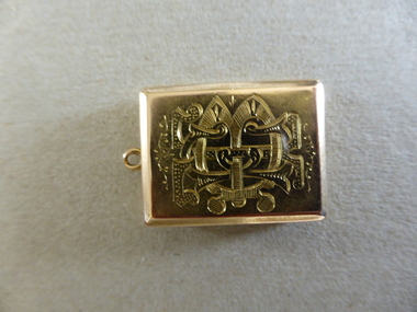
Locket, Locket Gold Bostock, 1880s
... as a Councillor, Mayor and businessman, with several buildings... and businessman, with several buildings and a street named after him ...This gold locket was presented to Thomas Edward Bostock on his retirement as Secretary of the Warrnambool Cricket Club on 1st August 1884. Thomas Bostock was a member of the Bostock family who had come from Tasmania to the Warrnambool district in the late 1840s. The Bostock brothers were prominent in the history of the area as pastoralists, shopkeepers, flour millers and Bond Store operators. They were all enthusiastic local cricketers. Thomas worked for the Bank of Australasia in the 1880s and was a keen footballer and cricketer. He moved to Geelong where he made his mark as a Councillor, Mayor and businessman, with several buildings and a street named after him. This item is of very high significance because:- 1. It is an attractive and valuable gold locket from Victorian times 2. It has strong local significance as it was presented in 1884 to a prominent Warrnambool man, Thomas Edward Bostock 3. It has considerable social significance, demonstrating the customs of the time of a man carrying a locket containing miniatures of personal interest to the bearer and of the presentation of such an object by a sporting club. This is a gold locket with a monogram of T.E. Bostock on the front and an inscription on the back. The locket has a small ring at the top so that it could be attached to a watch chain. The locket opens to reveal two oval inserts (one with a blue background) suitable for small photographs or miniatures.Monogram - T.E.B. Inscription: ‘Presented to T.E. Bostock by the Warrnambool Cricket Club on retiring from Secretaryship, Aug 1st 1884’ bostock, thomas edward bostock, warrnambool cricket club 1884, bostock brothers warrnambool, bostock locket -
 Warrnambool and District Historical Society Inc.
Document, Cheque book insert, Early 20th century
These are 1907 cheque book butts from the Bank of Australasia. The names in the book suggest that they came from the Warrnambool branch of this bank. A branch of the Bank of Australasia was established in Warrnambool in 1854 with new premises erected for the bank at the corner of Timor and Kepler Street in 1860. In 1953 the Bank of Australasia became the A.N.Z. Bank and the building in Kepler Street was closed. The butts are mainly drawn to an unidentified person, ‘self’ but some names included are ‘Dr E.J. Connell’, ‘O’Mahony’ (solicitor), ‘F. Tozer’, ‘A Bostock’, ‘P. Manifold’. These are all local Warrnambool names of the early 20th century.This cheque butt is of some interest as an example of the cheques issued by an individual in the early 20th century. The names in the butts are also of interest as prominent residents of Warrnambool at the time.This is a 1907 cheque book butt with a pale blue cover and 30 butts of cheques drawn from the Bank of Australasia. The last cheque has been poorly removed and part of the cheque is still in the book. Information on the Bank of Australasia policies is on the inside front cover and the butts have blue printed numbers on them. The information re the cheques drawn is handwritten in black ink. Most of the cheques are drawn to ‘self’. Butt One – ‘ No. A 261,761, 18 Jany, 1907, Self, £1-0-0’bank of australasia, bostock family, manifold family, warrnambool -
 Warrnambool and District Historical Society Inc.
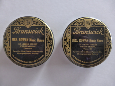
Cleaning Pad, Cleaning Pad Gramaphone Mrs Rowan, 1920s
John Brunswick from Switzerland came to U.S.A. in 1845 and established a business in Ohio making carriages and billiard tables. In 1874 a merger gave the company a new name of Brunswick and Balke Company and in 1884 it became Brunswick, Balke and Collender. In the early 20th century the company made other products including phonograph records and discs and in 1930 this section of the company was sold to Warner Brothers. Today it is known as the Brunswick Corporation. The patent for these cleaning pads was taken out in 1922. Matilda (Tilly) Rowan, the daughter of Robert and Ellen Lavery was born in Warrnambool in 1872 and by 1896 was advertising her stationery shop in the Oddfellows Hall in Koroit Street. She married Thomas Rowan in 1908. She had a music shop at 143 Liebig Street with one known date, 1930, and then transferred her business to the Oddfellows Hall building which she owned. She also operated the Plaza Picture Theatre in the same building. She died in 1948.Brunswick- Balke- Collender CompanyThese are two gramophone records cleaning pads. They are circular in shape with a tin top and felt cleaning pads. One pad is brown-coloured and the other is green-coloured. The metal tops have the name of the supplier and the name of the music shop in Warrnambool that gave out or sold the pads. The tops are painted black with gold-coloured printing. The tops have ornamental scrolls on the edges. ‘Brunswick, Mrs Rowan Music House, 143 Liebig Street, Warrnambool, ‘Phone 634, Agent for New Edison Diamond Disc Phonographs and Records, The Brunswick-Balke-Collender Company, Reg.U.S. Pat.Office, M de F. Marca Industrial Registrada, patented November 1922, Philadelphia Badge Co., Phila, U.S.A.’mrs tilly rowan, brunswick- balke- collender company -
 Warrnambool and District Historical Society Inc.
Letter, E H Macartney to Augustus Bostock, 1900
Augustus Bostock was the 9th child of Robert & Rachael Bostock of Vaucluse Epping Forest, Van Diemen’s Land. He was only 4 years old when his mother died. He was inspired by his father to seek his fortune in the Western District of Victoria. He arrived around 1850. He married Margaret Aitkin in July 1865. Augustus owned several properties in the district and leased others. He sat on the court of Warrnambool, Mortlake or Hexham as required. He resided at Marramook in Hawkesdale and later moved to Vaucluse in Hopetoun Road Warrnambool, where he died in 1920 at the age of 87. He was involved in many aspects of life in the Western District, racing, cricket, and social activities to name a few. This is one of a number of letters from E H Macartney of Delatite station to Augustus Bostock, with this one relating weather, details, sheep and the building of a sheep dip. This is one of a number of documents which relate to the Bostock family who were one of the most important pioneering families of the Western District. They owned and leased various properties around Warrnambool and were involved in many aspects of social and business life. This letter relates farming and social details at the timeCream lined paper with large margin on left side. Written in black ink.E H Macartney, Delatite Mansfield , 25th Sept 1900warrnambool, bostock, augustus bostock, -
 Warrnambool and District Historical Society Inc.
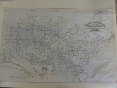
Map, Warrnambool 1859, Late 20th century (copy)
This is a copy of Bromfield’s 1856 map of Warrnambool and district. James Astley Bromfield was a pioneer settler in Warrnambool. He established a chemist’s shop in 1854, initially situated in Timor Street. He moved his shop to Liebig Street with a new building erected in 1875. Bromfield was a prominent resident of Warrnambool (Shire Councillor, Fire Brigade member, Cricket Club member, associated with horse racing etc). He was interested in preserving the history of Warrnambool and this map he produced in 1856 was an example of this interest.This is a copy only but this 1856 map is of prime importance as it contains the names of the original landowners of land in north Warrnambool and the surrounding district. It is a frequently-used resource by historians.This is a copy of a map of Warrnambool and its agricultural district published by James Astley Bromfield in 1856. The map is mounted on cardboard and has black printing on a white background. ‘Map of Warrnambool and its Agricultural District according to the Government Survey’s published by Astley Bromfield, Medical Hall, Warrnambool 1856, James Ferguson, Lithr., Melbne.’bromfield’s 1856, map, warrnambool and district -
 Warrnambool and District Historical Society Inc.
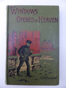
Book, Windows opened in Heaven - I S Rankin 1904, Early 20th century
This book has been given as an end-of-year prize to someone in the Warrnambool Corps in 1904. As the book is for a young person it is presumed that the recipient was in the Cadet Corps section of the local Volunteer Corps. Members of the Cadet Corps were usually from a unit formed within a school. As neither the Warrnambool Agricultural High School nor the Warrambool Technical School were established at that time the recipient was probably a pupil at a private boys’ school. This book is of interest as a prize given by the Warrnambool Corps to a local Warrnambool boy in 1904. It will be of greater interest if we can decipher the name of the Sergeant-Major and the name of the recipient. This is a hard cover book of 160 pages. It has an olive-green cover with an image in red, black and yellow of a young boy in front of some buildings. The front cover has black and red lettering and the spine has an image of a woman and the lettering in gold and red. The book has a full page black and white illustration at the front of the book and there are 18 chapters of text. There has been a book plate pasted on to the inside cover but there is now only a fragment left. What is visible is handwritten in black ink. ‘….. Serg.-Major, Warrnambool Corps, Dec. 13th 1904’. warrnambool corps, warrnambool cadet corps, history of warrnambool -
 Warrnambool and District Historical Society Inc.
Plate, Warrnambool Congregational Church, Early to mid 20th century
This plate was probably part of a crockery set used by the Warrnambool Congregational Church for church functions and receptions. The Warrnambool Congregational Church began when two men, Robert Winton and Thomas Nayler, met in 1862 to discuss the possibility of establishing a church of the Independent order. As a result the first Congregational Church was opened in Liebig Street, Warrnambool in 1864 with William Pentland as the first Minister. Samuel Nettleton was a notable member of the congregation, being the Superintendent of the Sunday School for 60 years. In 1940 the Congregational Church moved to a building in Henna Street and in 1973 the Congregational Church merged with the Methodist Church to form what is known today as the Uniting Church. In 1976 the former Congregational Church building in Henna Street was sold to the Salvation Army. This plate is of interest as a memento of the Warrnambool Congregational Church, an institution that no longer exists under that name. This is a cream-coloured china plate with a gold trim around the outer edges and the name of the church in the centre in a black and white scroll pattern. The gold trim is now almost obliterated. The edges of the plate are chipped in several places and the plate is much stained and blotched. ‘Warrnambool Congregational Church’ congregational church, warrnambool, history of warrnambool -
 Kiewa Valley Historical Society
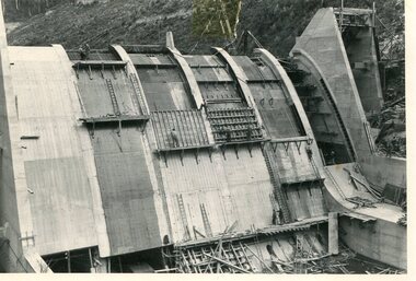
Photo - Junction Dam Construction, Circa 1940's
Junction (Lake Guy) Dam is a 'slab and buttress' type wall. A timber frame is built and then filled with concrete. The first batch of concrete was placed in September, 1940. By June, 1941 the buttresses were finished to a height safe from floods and in October of that year a flood of 2,800 cusecs occurred but with only slight damage to the installations. Industrial trouble caused some delays but there was also slow progress on the part of the contractor and the work was taken over by the S.E.C., terminating the contract. The dam was completed in March, 1944. A walkway was made through the dam wall. Lake Guy was named after Mr. L.T. Guy who was the Resident engineer, in charge of construction work and associated activities on the Kiewa Area from 1939 to November 1946Photos of the construction of the Junction Dam detail the harsh conditions faced by construction workers, building dams and villages to accommodate workers in the 1940s to the 1950s. Australia at this period in time, experienced a surge of population (influx of World War II refugees), which was the catalyst for developing and undergoing an enormous hydroelectricity program for the Alpine regions, both in Victoria and New South Wales. This program was initiated to supply electricity to the major southern Australian cities of Adelaide, Melbourne and Sydney. It was thought that these developments would reduce, if not eliminate, the requirement for coal driven power stations. However time has demonstrated that these power stations have not matched the demand required by the industries and the populations of the major urban and cities.Black and white photograph of Junction Dam constructionjunction dam, bogong, secv -
 Kiewa Valley Historical Society
Photo - Junction Dam Diversion Tunnel
Junction (Lake Guy) Dam is a 'slab and buttress' type wall. A timber frame is built and then filled with concrete. The first batch of concrete was placed in September, 1940. By June, 1941 the buttresses were finished to a height safe from floods and in October of that year a flood of 2,800 cusecs occurred but with only slight damage to the installations. Industrial trouble caused some delays but there was also slow progress on the part of the contractor and the work was taken over by the S.E.C., terminating the contract. The dam was completed in March, 1944. A walkway was made through the dam wall. Lake Guy was named after Mr. L.T. Guy who was the Resident engineer, in charge of construction work and associated activities on the Kiewa Area from 1939 to November 1946.Diversion dams are installed to raise the water level of a body of water to be redirected. The redirected water is used for hydro electric power generation. A diversion tunnel is usually bored through solid rock next to the dam site to bypass the dam construction site. The dam is built while the river flows through the diversion tunnel.Photos of the construction of the Junction Dam detail the harsh conditions faced by construction workers, building dams and villages to accommodate workers in the 1940s to the 1950s. Australia at this period in time, experienced a surge of population (influx of World War II refugees), which was the catalyst for developing and undergoing an enormous hydroelectricity program for the Alpine regions, both in Victoria and New South Wales. This program was initiated to supply electricity to the major southern Australian cities of Adelaide, Melbourne and Sydney. It was thought that these developments would reduce, if not eliminate, the requirement for coal driven power stations. However time has demonstrated that these power stations have not matched the demand required by the industries and the populations of the major urban and cities.Black and white photograph of Junction Dam diversion tunnel at Bogong VillageHandwritten on back - Junction Dam Diversional Tunnelbogong, secv, junction dam, lake guy -
 Kiewa Valley Historical Society
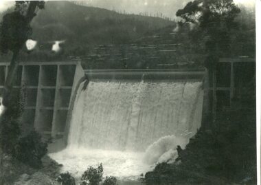
Photograph - Junction Dam spilling
Junction (Lake Guy) Dam is a 'slab and buttress' type wall. A timber frame is built and then filled with concrete. The first batch of concrete was placed in September, 1940. By June, 1941 the buttresses were finished to a height safe from floods and in October of that year a flood of 2,800 cusecs occurred but with only slight damage to the installations. Industrial trouble caused some delays but there was also slow progress on the part of the contractor and the work was taken over by the S.E.C., terminating the contract. The dam was completed in March, 1944. A walkway was made through the dam wall. Lake Guy was named after Mr. L.T. Guy who was the Resident engineer, in charge of construction work and associated activities on the Kiewa Area from 1939 to November 1946Photos of the construction of the Junction Dam detail the harsh conditions faced by construction workers, building dams and villages to accommodate workers in the 1940s to the 1950s. Australia at this period in time, experienced a surge of population (influx of World War II refugees), which was the catalyst for developing and undergoing an enormous hydroelectricity program for the Alpine regions, both in Victoria and New South Wales. This program was initiated to supply electricity to the major southern Australian cities of Adelaide, Melbourne and Sydney. It was thought that these developments would reduce, if not eliminate, the requirement for coal driven power stations. However time has demonstrated that these power stations have not matched the demand required by the industries and the populations of the major urban and cities.Black and white photograph of Junction Dam spilling at Bogong VillageHandwritten in pencil - Junction Dam spillingbogong, junction dam, lake guy, secv -
 Kiewa Valley Historical Society
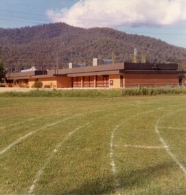
Photos - Mt Beauty Buildings in 1973. Set of 8, 1973
The shopping centre in Mt Beauty, both buildings and streetscape, have undergone significant changes since 1973. The kindergarten has undergone extensive remodelling, The Chalet has been replaced by Svarmisk Resort and Accommodation Spa. Tawonga hospital has undergone extensive renovation and is now Mt Beauty Hospital AND Kiewa Valley House. The Workman’s Club changed name to the Country Club and has since closed down. Hospital and Kiewa Valley House now occupy what is shown as a vacant lot opposite the motel which is now called Mt Beauty Motor Inn.The houses in Mt Beauty were brought in by the State Electricity Commission of Victoria when they constructed Mt Beauty Town for their workers building the Kiewa Hydro Electric Scheme. Mt Beauty is unique began as a construction town in the late 1940's.Colour photographs of various buildings in Mt Beauty taken in 1973 1. Workman’s Club 2. View over the pondage 3. Tawonga Hospital (Mt Beauty) 4. Mt Beauty Chalet 5. Mt Beauty Kindergarten 6. The Merjei Motel 7. 8 Valley Avenue 8. Shopping Centre Handwritten in ink on the back of photos 1. Workman’s Club 1973 (after the brick makeover) From the sports oval – the high school is to the right 2. A view over the pond 1973 3. Tawonga Hospital 1973 (Mt Beauty) 4. Mount Beauty Chalet 1973 5. Kindergarten 1973 6. The Merjei Motel 1973 7. Our house at 8 Valley Ave 1973, Owner after us erected the car port, let the front hedge run amok and vanquished the vegetable garden and citrus trees Dad created. 8. Shopping Centre 1973. At the end of the street is the hospital (believe it is now Mt Beauty Bush Nursing Hotel) mt beauty, workman's club, chalet, tawonga hospital -
 Kiewa Valley Historical Society
Photo - School Children Tawonga Primary School, Circa 1920 (estimate)
Tawonga is in the Kiewa Valley, where local farmers lived with their families. The school was originally opened July 27 1880, situated on 8 acres near the current township of Tawonga. The school was erased by fire in 1900 and all records destroyed. The school was then moved to the Old Tawonga Hall. In 1910, the school was shifted to its present site on 3 acres of land donated by Frank Cooper. The school building and attendance continued to grow, especially during construction of the Kiewa Hydro Electric Scheme.Tawonga Primary School has educated the local farming and town children for many years. It is an excellent source of the names of the local families of the time ie: Vera Ryder – front row, far right (little girl with the wide headband.)Copy of black and white photograph of pupils at Tawonga Primary School. Circa 1920 (estimate)tawonga primary school, kiewa valley -
 Kiewa Valley Historical Society
Photo - School Children Tawonga Primary School, Circa 1920 (estimate)
Tawonga is in the Kiewa Valley, where local farmers lived with their families. The school was originally opened July 27 1880, situated on 8 acres near the current township of Tawonga. The school was erased by fire in 1900 and all records destroyed. The school was then moved to the Old Tawonga Hall. In 1910, the school was shifted to its present site on 3 acres of land donated by Frank Cooper. The school building and attendance continued to grow, especially during construction of the Kiewa Hydro Electric Scheme.Tawonga Primary School has educated the local farming and town children for many years. It is an excellent source of the names of the local families of the time. Copy of black and white photograph of pupils at Tawonga Primary School. Circa 1920 (estimate)tawonga primary school, kiewa valley -
 Kiewa Valley Historical Society
Photographs x 2 1. Lake Guy & Bogong Village 2. Bulldozer moving rocks
1. In 1940 Field Headquarters for the Kiewa Scheme were established at Bogong with office, workshop facilities and accommodation for workmen, staff and some families constructed. (There had been a 'tent camp' on this site in 1939 but was destroyed by bushfires) Construction of accommodation continued until 1947. A total of 40 houses plus a hostel for single staff, post office, police station, medical centre and primary school all with water and sewerage and electricity supply. The staff hostel was known as Kiewa House and is now occupied by the Education Department. Lake Guy was named after Mr. L.T. Guy who was the Resident Engineer in charge of construction work and associated activities on the Kiewa area. He held this position from 1939 to November 1946 when he was transferred to Head Office. 2. Example of the type of heavy machinery used in clearing and building of Lake Guy, Bogong Village and Clover Dam 1. The Bogong Township was developed firstly as an accommodation centre (base camp) for construction workers employed under the Kiewa Hydroelectric Scheme. At the completion of the scheme, in the 1960's, the village was opened to public/tourism use. Strict environmental control has not allowed for any extensive redevelopment in tourist accommodation and basically restricted it to the accommodation initially built for the construction workers. Lake Guy is one of the many water storage reservoirs used to supply the power stations their main power to run the huge turbines generating the final product, electricity 2. Pictorial record of the types of machinery used in the development of Bogong Village and the Hydro-electricity scheme including the Clover Dam. Note the lack of safety equipment worn by construction workers of the period. 2 black and white photographs taken at Bogong 1. Lake Guy with Bogong Village in the background 2. Workman in bulldozer clearing rocks, possibly for construction at Bogong1. Handwritten in blue ink on back of photo 'Lake Guy showing Bogong Village' 2. No markingslake guy, bogong village, secv -
 Kiewa Valley Historical Society
Papers - Falls Creek Tourist Area Management Committee, August 1984
Falls Creek is a ski resort in the north east of Victoria on the Bogong High Plains. Members of business's (accommodation & restaurants) formed the Falls Creek Chamber of Commerce to promote tourism 'under' the Falls Creek Tourist Area Management Committee. The Falls Creek Tourist Area Management Committee under the direction of the State Electric Commission of Victoria came into effect in 1959 and from then on building sites were leased and building and sewerage controls were applied. In 1979 the Victorian State Government had established the Ski Industry of Victoria working party with a brief report on its operation. These papers give an insight into the business of the Falls Creek Chamber of Commerce in 1984 eg. car parking, noise, closure of the resort due to heavy snow falls, the media and general development of the resort. Local business people are named as attending the meeting indicating many non English surnames. 4 yellowed papers typed on both sides of the first 3 pages. irst paper has 6 items listed re Falls Creek Chamber of Commerce / Sub Committee on General Booking Conditions.Dated 15th August 1984 Next 3 papers dated 13th August 1984 Falls Creek Chamber of Commerce / Minutes of General Meetingfalls creek, ski resort, bogong high plains, falls creek chamber of commerce, snow, ski lodges, -
 Kiewa Valley Historical Society
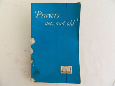
Book - Religious Education, Prayers New and Old, 1972
Students attended Sunday School classes at the Kergunyah Presbyterian Church. Sunday school was held in a little 16 foot square wooden building which came from Rocky Valley after it was no longer needed there. Ewen Wallace's father initiated and organised the move. C2011 the building was knocked down because of white ants. The Presbyterian Church will be 125 years old in 2015.Historical: Religious Education: This book was used by students who attended the Sunday School classes at the Kergunyah Presbyterian Church. Religion: Presbyterian Church at Kergunyah, in the Kiewa Valley, celebrates its 125th anniversary in 2015 after being handed over to the uniting Church in the 1970s.Bright shiny aqua small book with vertical black thin line 3 quarters of the way along from the spine. This black line goes through the middle of a picture of a book which is drawn in black with a rectangular of white around it. Title is in white and cursive script. Title is written in bold white print along spine. Back of book has ISBN number in blackPencil inside on cover page "170" "3/MA" Pencil inside on back cover page 15 names listed and $2.40 Warwick, Ken, Debbie, Cameron, Thomas, Anna, Ricki, Glen Simpson, Brett, Mathew, Lorinda, Tracey, Luke, John, Meganreligion, prayers, ewen wallace, kergunyah, presbyterian church, religious education, sunday school -
 Kiewa Valley Historical Society
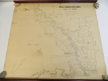
Map - Kiewa Valley, Parish Map of Mullindolingong, 12/10/1906
The map shows the names of people living in the parish of Mullindolingong in 1906. These people had leases or licences giving the reader an insight into the number of people in the area and an understanding of the size of their holdings. Infrastructure is also given including shops, schools, churches etc. Presumably it was used by the Ryder family.This map gives an historical insight into the parish of Mullindolingong as it names people and the infrastructure - roads, buildings etc. as it was in 1906. This enables the reader to compare the area at the time with other times and other places and to have an understanding of the early settlers in the area.This is a very old paper or parchment map with wooden rods top and bottom. The top rod has ribbons attached to enable hanging. The map shows the current leases and licences and when they were held by during this period, circa 1906.Mullindolingong County of Bogong. This plan has been prepared by The Most Reliable Data in the Possession of the Department up to the date of its Compilation. Information respecting Leases or Licences which await Final Completion is not recorded.parish of mullindolingong map; ryder family; early settlers; -
 Kiewa Valley Historical Society
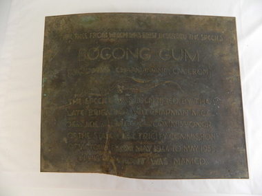
Plaque - Eucalypt Chapmanania, 1947
W.D.Chapman had a keen interest in botany and was particularly interested in Eucalyptus species. He was first to discover the tree which now bears his name on his numerous visits to the Kiewa power station which is situated near the Bogong High Plains. He was a Commissioner and later the Chairman of the State Electricity Commission of Victoria, the organisation in charge of building the Kiewa Hydro Scheme. The tree is a cross between two eucalypts. The trees are unique as they cannot procreate. There were two 'Bogong Gum' trees. One at Cranky Charlies and one on the way up to the High Plains passed by the Ryder family on their way up.This plaque was beside the Falls Creek Road and indicated the location of the 'Bogong Gum' tree. The tree was burnt in the 2003 bush fires but survived only to be killed in the 2006 bush fires. There were two 'Bogong Gum' trees. One at Cranky Charlies and one on the way up to the High Plains passed by the Ryder family on their way up. Heavy bronze plaque embossed with inscription. On the back is a large rectangular steel piece bent at the bottom to form a 'U' shape. One end of the 'u' is attached to the plaque and the other end has two holes for bolts enabling the plaque to be attached near the tree. One bolt is in a hole."Type tree from which was first described the species / Bogong Gum / (Eucalyptus Chapmaniana, Cameron) / The species was identified by the / late Brigadier W. D. Chapman M.C.E., / D. Eng., M.I.E. Aust., M.I.C.E. Lond. Commissioner / of the State Electricity Commission / of Victoria from May 1944 to May 1955, / in his honour it was named."plaque; state electricity commission of victoria; w.d.chapman; eucalyptus; bogong gum tree; falls creek road -
 Christ Church Anglican Parish of Warrnambool
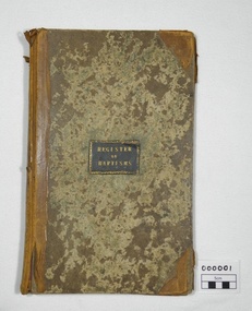
Register, Register of Baptisms 1850 - 1908
This Register is the first Baptismal Register for the Anglican Church in Warrnambool and District. The Vicar at the time, Peter Tuelin Beamish, oversaw the development of the first Church and the subsequent building of Christ Church.Large book, hard covered with leather spine and corners. End pages marbled paper. Baptismal entries under headings: When Baptized; When born; Child's Christian name; Parent's name-Christian, Surname; Abode; Quality or Profession; By whom the ceremony was performedof, warrnambool, church, england, anglican, parish of warrnambool, baptisms, beamish, christenings, church records -
 Warrnambool and District Historical Society Inc.
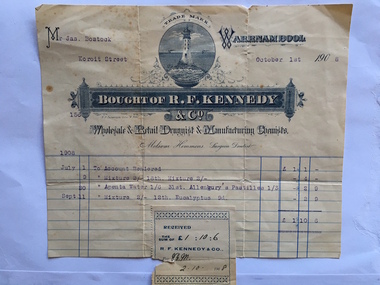
Docket, R F Kennedy, 1908
James Bostock, a grazier, was a member of the Bostock family, prominent Warrnambool pastoralists and businessmen who had come from Tasmania in the mid 1840s and settled in the Warrnambool area. The chemist shop of R.F. Kennedy was established in Warrnambool in 1880 and quickly became one of the leading businesses in the town. Kennedy was a wholesale, retail and manufacturing chemist in Timor Street (the building still exists) and a prominent community member and a Town Councillor. He died in 1903 but the business continued to use the name of R. F. Kennedy and Co. until 1924. This docket is of some interest as it contains the names of the R.F. Kennedy chemist shop and James Bostock , a prominent Warrnambool resident. This is a cream-coloured docket issued by R.F.Kennedy & Co. to James Bostock in 1908. The printing shows a variety of styles in blue and white and the page has blue printed lines. The famous Kennedy symbol of a lighthouse is printed prominently and the name of Kennedy is contained in an ornamental banner. The sales information is printed in blue type and there is a Kennedy stamp attached to the bottom of the docket and this is slightly overlapping the page. There is a small tear in the stamp and at the top of the docket. ‘Mr Jas. Bostock, Koroit Street, October 1st 1908, July 1st , To Account Rendered, £1/1/-, July 9, Mixture 2/-, 18th, Mixture, 2/-, 4/-, July 30, Apenta Water, 1/6, 31st Allenbury’s pastilles, 1/3, 2/9, Sept. 11, Mixture 2/-, 12th, Eucalyptus, 9d., 2/9, Total, £1/10/6’r.f. kennedy, james bostock, r f kennedy chemist, warrnambool history -
 Warrnambool and District Historical Society Inc.
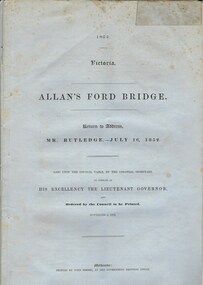
Document, Allan’s Ford Bridge 1852, 1852
This is an original Victorian Government document containing the printed version of 37 reports and letters regarding the building of the first Allansford bridge completed early in 1852. The correspondence dates from October 1850 to February 1852 and includes letters and reports from Melbourne Government employees such as Robert Hoddle, Chief Surveyor, David Lennox, Superintendent of Bridges and Lieutenant – Governor Charles La Trobe. The correspondence from local settlers included the names of William and John Allan, John Davidson and James Coulstock. The correspondence shows that some settlers in the Warrnambool/Port Fairy district wanted a portion of the Government allocated funds spent on the local roads and bridges in other locations. The 1852 Allansford bridge cost £480 and was replaced in 1870. This document has strong historical significance as it relates to one of the earliest State government works in the district and records the public imput into the decision.. It contains opinions and correspondence between a number of early settlers in the district at the time.Grey/blue paper document with black text. 21 pages plus 4 page index at back.allan's ford 1852, allansford bridge, allansford, history of allansford, warrnambool -
 Warrnambool and District Historical Society Inc.
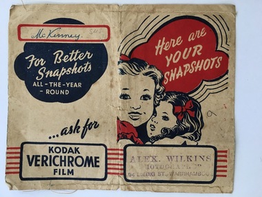
Functional object - Packaging, Photo Wallet McKinney, 1940s or 1950s
This folder came from the photographic studio of Alex Wilkins. For over 35 years in the 20th century he was one of the best-known commercial photographers in Warrnambool. In 1938 he purchased the building known as Jordan Studios (94 Liebig Street) and worked there until the 1960s. In the 1940s he became interested in producing movie films documenting local news and scenes. The name ‘McKinney’ on this folder indicates that the contents belonged to someone in the Warrnambool area as William McKinney had a general store in Lava Street in the 1870s and 80s and there are still McKinney residents in Warrnambool today. This folder is of some interest as it comes from the studio of Alex Wilkins, one of Warrnambool’s most important photographers in the 20th century. This is buff-coloured paper folded in three places to make a folder with sleeves at each end to insert photographs or photograph negatives. The folder is stitched with cotton at the top and the bottom and some of the stitching is coming undone. The inside sleeves have black printed advertising material on them and the front cover has a red and black image of two little girls. The back cover has a red and black advertisement for Kodak Verichrome film.Back Cover: ‘McKinney’ Front Cover: ‘Alex Wilkins, Photographer, 94 Liebig St., Warrnanmbool’ (stamp) alex wilkins, mckinney family, warrnambool -
 Warrnambool and District Historical Society Inc.
Map, Plans (5) showing Subdivisions of Warrnambool, 1989
These plans have been drawn by Steve Hester for the Warrnambool City Council to illustrate the allotments in Warrnambool concerned with the subdivisions of 1989. The streets have not been named but there is an indication of the area with the identification of known buildings (eg Hospital) and the plan numbers of each allotment is clearly marked. These numbers corresponded to the plan numbers registered in card files and ledgers in the Warrnambool City Council offices. The scale of the plans was 1 to 5000. These plans are of considerable interest because they show Warrnambool street subdivisions of 1989 in illustrative form. They show how information was collated in the late 1980s before the widespread use of computer digital means to describe and store information.These are five hand-drawn sheets showing plans of sub-divisions in Warrnambool streets in 1989 (Warrnambool City Council material). The plans are multi-coloured (crayons) and show allotments with plan numbers. The first plan has much of the material torn off but the location is known to be in the Russells Creek area. Some of the green tape around the edges is missing. Plans two to five are almost intact and are bound with green tape. Plan Two- Industrial Estate of West Warrnambool; Plan Three – Hospital/Merrivale/ Lake Pertobe areas; Plan Four – North Warrnambool, Wollaston/Brierly areas; Plan Five – Flaxman Street area. ‘Subdivision Plan, Reference Guide, Steve Hester, Oct. 1989’. warrnambool street subdivisions, steve hester, history