Showing 1159 items
matching shire hall
-
 Charlton Golden Grains Museum Inc
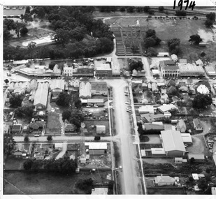
Photograph, Aerial photo of Armstrong St, Charlton, c.1974
... on the left, Shire Hall on the right. High St runs across the photo... on the left, Shire Hall on the right. High St runs across the photo ...Aerial photo looking down Armstrong St. Camp street on the left, Shire Hall on the right. High St runs across the photo. The Avoca River is visible in the top LH side. The swimming pool and bowling green is above the rive. On High St (from L-R) Dr Surgery, H Bath Chemist, Grocery, Roy Dobson, Hairdresser, Stowe's, Westpac Bank (two storey white building), Dillon's Building, Globe Hotel, Charlton Club, butcher shop, Arundell's shoe shop, Watson's Stock & Station Agency, Bullock's grocery, Williams St (Curtin Ave), Bannon's Butchers, East Charlton Hotel, MB Luth & Co, Lou's cafe. The old sale yards are at the end of Williams Street. Camp St lower side (from L-R) Court House, Police residence, Police Station, Telecom on corner. The photo is thought to be taken from Ossie Sanderson's airplane in 1974.Black & white aerial photo looking down a broad street that ends in a t-intersection. There is a street that comes off to the left about 1/3 of the way up the photo. There is a large building directly opposite this street. In the upper right there is a two storey building with arches on its verandah. In the upper LH side there is a swimming pool and bowling greens.armstrong st charlton, charlton, business, industry, westpac bank, globe hotel, east charlton hotel, dillon building -
 Linton and District Historical Society Inc
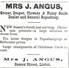
Photograph, Advertisement for Mrs. J. Angus, "Grocer, Draper, Tinware & Fancy Goods Dealer", 1896
... Mrs Angus operated a shop next to the Shire of Grenville...Mrs Angus operated a shop next to the Shire of Grenville ...Mrs Angus operated a shop next to the Shire of Grenville hall from about 1887 (when her husband bought the shop) until at least the late 1890s. The shop was afterwards run by her son William Angus.Enlarged black and white photograph of an advertisement which appeared in 'The Grenville Standard' newspaper on 19 December 1896. The advertisement drew readers' attention to a range of "New Season's Goods just arriving" at a shop in Sussex Street, Linton, run by Mrs. J. Angus (Wilhelmina Angus, the wife of John Angus).sussex street linton, shops, newspaper advertisements, wilhelmina angus, mrs j angus, w. angus tailor -
 Otway Districts Historical Society
Photograph, Langford, Weston, Goods train arriving at Beech Forest, 1961, 9 August 1961
... is the Beech Forest Hall and Shire of Otway offices. Colour.... Hall and Shire of Otway offices. Colour. Goods train arriving ...From late in 1960 VR took what were the first definite steps to close the Colac-Beech Forest line. 1,101 tonnes of freight per year flowed from Colac to Beech Forest because of increasing competition from the roads. From 1 July 1960 onwards, when pulpwood (hardwood) stopped being shipped from Beech Forest, a maximum of only 7,000 tonnes/year would be shipped to Colac. Including special trips passenger revenue earned a little more than $200 per annum. The issue of second-hand sleepers stopped entirely and the two track gangs only patrolled the track and tightened loose bolts. The line did not earn its way and on 4 November 1960 it was recommended that services over the narrow gauge line be discontinued.The rear of a goods train from Colac arrives at Beech Forest on 9 August 1961. The other line is the former Crowes line truncated at Weeaproinah in January 1955. In the background is the Beech Forest Hall and Shire of Otway offices. Colour.colac; beech forest; railway; -
 Wodonga & District Historical Society Inc
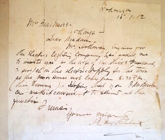
Letter - Electricity comes to Wodonga - 1912 letter to Mrs Beardmore
... Street between South Street and the Shire Hall as well as a few... Street between South Street and the Shire Hall as well as a few ...Mrs Jessie Beardmore, wife of the Shire President, Mr Henry Beardmore, was invited to switch on the electrical current at the power house in Wodonga on 15th January 1912. This was not the official opening of the newly installed system which took place a few weeks later. Disagreement existed amongst Shire Councillors about the official opening, several of them including Mr Beardmore believing the opening should only take place when the scheme was completed. However Dr Schlink, Mr D. M. Stavely, Cr Twomey and Mr C. Holloway, Engineer for the Electric Lighting Company, arranged a small ceremony to turn lights on for the first section of the scheme. This included street lighting along Sydney Street between South Street and the Shire Hall as well as a few business houses and private establishments, with the balcony of the Terminus Hotel illuminated by over 100 lights. Other areas and buildings were connected over the following weeks. Mr Beardmore was not present at the beginning of proceedings but joined the crowd in the street. During a small number of speeches, credit for his work to instigate and further the introduction of electricity to Wodonga was given to Councillor Twomey, referred to as “the father of the scheme”. This item is significant because it records the first connection of electricity to Wodonga in 1912.A hand written letter addressed to Mrs Beardmore of Wodonga. A portrait of Mrs Beardmore is also included. A transcript of the letter is included below. Wodonga 15 -1-12 Mrs Beardmore Wodonga Dear Madam, Mr Holloway, Engineer for the Electric Lighting Company, has invited me to invite you as the wife of the Shire President to switch on the electric supply for the town at the power house not later than 8.30PM (this evening). Hoping that you and Mr Beardmore can make it convenient to attend. I remain yours sincerely, R. H. Schlinkbeardmore family, electricity in wodonga -
 Lakes Entrance Historical Society
Photograph - Union Church Nicholson, 1999
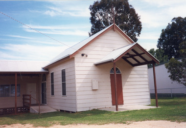
... . In 1971 it was given to Tambo Shire as a Recreation Hall.... In 1971 it was given to Tambo Shire as a Recreation Hall ...Built 1890, used as Church until August 1970, ministers of Congregational Methodist and Anglican taking services and ceremonies. In 1971 it was given to Tambo Shire as a Recreation Hall for the people of Nicholson.Colour photograph of Nicholson Union Church and Hall, Princes Highway, showing a small building, clad in Hardiplank or similar material, gable roof, with additions at right angle at rear. Nicholson Victoriareligion, buildings -
 Orbost & District Historical Society
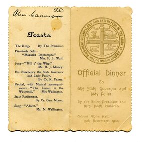
menu, 1912
... Fuller to be held in the Orbost Shire Hall on November 19, 1912... Fuller to be held in the Orbost Shire Hall on November 19, 1912 ...This item is an invitation to a dinner given by the Shire President and Mrs Hugh Cameron for the State Governor and Lady Fuller to be held in the Orbost Shire Hall on November 19, 1912. The governor and his wife left Melbourne on November 14 on a visit to East Gippsland. Hugh Cameron (1850-1921) was on the Orbost Shire council from 1892-1915. (more info. in O.D.H.S. newsletter -Tambo Shire) The Shire of Orbost was a local government area about 380 kilometres east of Melbourne, the state capital of Victoria, Australia. The shire covered an area of 9,347 square kilometres (3,608.9 sq mi), and existed from 1892 until 1994. Originally, Orbost was part of the Bairnsdale Road District which was created on 30 April 1867. Splitting away as part of the Shire of Tambo in 1882, Orbost was first incorporated as a shire in its own right as the Shire of Croajingolong on 30 May 1892. It received its present name on 17 February 1893. On 3 January 1913 part of its western riding was annexed to Tambo as its Cunninghame Riding. On 2 December 1994, the Shire was abolished, and merged with City and Shire of Bairnsdale, Shire of Tambo, most of Shire of Omeo and the Boole Boole Peninsula from Shire of Rosedale into the Shire of East Gippsland. This item is associated with Orbost Shire Council which no longer exists. It is also associated with Hugh Cameron.A small menu on a cream folded card with blue print. On the front is stamped a large blue logo of the Shire of Orbost. The text is "Official Dinner". On the back is a list of toasts and inside is the menu.On back - handwritten - "Alex Cameron"orbost-shire-council cameron-hugh -
 The Beechworth Burke Museum
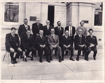
Photograph, 1973
... taken in front of the Beechworth Shire Hall. The Hall... taken in front of the Beechworth Shire Hall. The Hall ...Taken in 1973, this photograph features 13 men in suits, most of whom are council members of the United Shire of Beechworth, as well as a secretary and engineer. The photo is taken in a formal setting, suggesting there may have been an occasion at this time (potentially surrounding or related to the August council meeting). Previously a district (1856), then a borough (1863) and separate shire (1866) at this time the Local Government Area (LGA) had been known by this name for approximately two years, after having amalgamated with the still-existing borough. Beechworth amalgamated with Rutherglen and Chiltern Yackandandah to become the Indigo Shire Council in 1994. Little has been found about the men in the photograph, however this was at also around the time that women were becoming more widely accepted into positions on Victorian council (such as Valerie Mason, who was elected the first President of the United Shire of Beechworth council 6 years after this photograph.) The photograph has been taken in front of the Beechworth Shire Hall. The Hall was designed by architects J.J. Coe and Thomas Dalziel and is dated to 1859. Originally the building was used as the Shire Offices but also doubled as a fire station and a courthouse, with still surviving cells underneath. The Town Hall is now home to the Visitor Information Centre, is the starting point for historical Precinct walking tours and is available for hire for events or community meetings.The Beechworth Town Hall is one of five distinctive granite buildings on Ford Street that comprise the Justice Precinct, and is listed on the Victorian Heritage register. This photograph captures the ongoing importance and use of the Beechworth Town Hall and its ties to Council operations in the 1970s.Black and white rectangular photograph print matt photographic paperReverse - written in pencil upper right corner: 1997.2602; stamped in black ink across centre margin: Beechworth shire council Aug.1973/ Crs.H.H.Warner, H.C.Lucas, L.W. Powell, L. Leentjes, R.C. Sewell, T.J. Carroll/ G.Gray (Secry), Crs.R.P. O'Connor, D. Nankervis, D. McKenzie-McHaig, J.J. Macaulay, H.R. Sinclair/ D.Pope (Engineer), Absent Cr.J.V.Diffey; written in pencil in cursive lower left margin: Absent J Diffey; written in pencil bottom right edge: BMMA02602beechworth shire council, crs.h.h.warner, h.c.lucas, l.w. powell, l. leentjes, r.c. sewell, t.j. carroll, g.gray (secry), crs.r.p. o'connor, d. nankervis, d. mckenzie-mchaig, j.j. macaulay, h.r. sinclair, d.pope (engineer), cr.j.v.diffey, beechworth town hall -
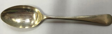
 Kew Historical Society Inc
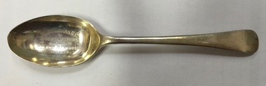
Award, Boroondara Rifle Club Spoon Competition : 800, 900 yds won by J S Penrose 1905, 1905
... in connection with the Boroondara Rifle Club was held in the shire hall... in connection with the Boroondara Rifle Club was held in the shire hall ...In 2000, three silver trophy spoons were donated to the Kew Historical Society by the National Trust (Victoria). At the time, the trophies were believed to have been awarded to J.S. Penrose for victories in events held by the Boroondara R.C. [Rifle Club] in 1905 and 1906. The Boroondara Rifle Club was a separate entity to the Kew and Hawthorn Rifle Clubs. The first reference to the Club on Trove is on 11 April 1900, when the Club was established and the committee elected. It is recorded that: “the adjourned meeting in connection with the Boroondara Rifle Club was held in the shire hall on Monday evening; Mr. A. J. Smith, J.P., in the chair. It was decided that the name of the club should be the Boroondara Rifle Club, and that it should embrace the whole shire, with butts at some convenient and accessible spot. A number of additional members were sworn in, making the total enrolled to date about 70. The following gentlemen were elected as office bearers: — President, Sir Frederick Sargood. M.L.C.: vice-presidents, Messrs. Wm. Knox, M.L.C.; F. Madden, M.L.A., and A. J. Smith (president of the shire); hon. captain, Mr. John Mc Whae (chairman of the Stock Exchange) ; committee. Messrs. T. W. Gaggin, J. B. Gilfillan, Cr. Lewis. Cr. Rooks and Cr. Beckett; hon. treasurer. Mr. G. A. Darling; hon. secretary, Mr. A. J. .Macarthur”.The last recorded meeting of the Rifle Club was in 1916, at “Adam’s Hall, upper Hawthorn” when a new committee was elected. Silver trophy spoon awarded to J.S. Penrose by the Boroondara Rifle Club for a victory in the Spoon Competition.Boroondara R.C. / Spoon Competition / 800, 900 yds /won by J.S. Penrose. Score 70 / 21-10-05boroondara rifle club, silver trophies -
 Kew Historical Society Inc
Award, Boroondara Rifle Club Spoon Competition : 200, 300 yds won by J S Penrose 1906, 11/02/1906
... in connection with the Boroondara Rifle Club was held in the shire hall... in connection with the Boroondara Rifle Club was held in the shire hall ...In 2000, three silver trophy spoons were donated to the Kew Historical Society by the National Trust (Victoria). At the time, the spoons were believed to have been awarded to J.S. Penrose for victories in events held by the Boroondara R.C. [Rifle Club] in 1905 and 1906. The Boroondara Rifle Club was a separate entity to the Kew and Hawthorn Rifle Clubs. The first reference to the Club on Trove is on 11 April 1900, when the Club was established and the committee elected. It is recorded that: “the adjourned meeting in connection with the Boroondara Rifle Club was held in the shire hall on Monday evening; Mr. A. J. Smith, J.P., in the chair. It was decided that the name of the club should be the Boroondara Rifle Club, and that it should embrace the whole shire, with butts at some convenient and accessible spot. A number of additional members were sworn in, making the total enrolled to date about 70. The following gentlemen were elected as office bearers: — President, Sir Frederick Sargood. M.L.C.: vice-presidents, Messrs. Wm. Knox, M.L.C.; F. Madden, M.L.A., and A. J. Smith (president of the shire); hon. captain, Mr. John McWhae (chairman of the Stock Exchange) ; committee. Messrs. T. W. Gaggin, J. B. Gilfillan, Cr. Lewis. Cr. Rooks and Cr. Beckett; hon. treasurer. Mr. G. A. Darling; hon. secretary, Mr. A. J. Macarthur”. The last recorded meeting of the Rifle Club was in 1916, at “Adam’s Hall, upper Hawthorn” when a new committee was elected. Engraved silver trophy spoon awarded to S.J Penrose by the Boroondara Rifle Club for a victory in the Spoon Competition of 1906Boroondara Rifle Club / Spoon Competition / 200, 300 yds / Won by S.J. Penrose / 11-2-06boroondara rifle club, j.s. penrose, sport, shooting, trophy, a. j. smith, frederick sargood, william knox, f. madden, a. j. smith, john mcwhae, t. w. gaggin, j. b. gilfillan, lewis, rooks, beckett; g. a. darling; a. j. macarthur -
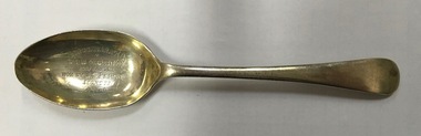 Kew Historical Society Inc
Award, Boroondara Rifle Club Spoon Competition : 500, 600 yds won by J S Penrose 1906, 1906
... in connection with the Boroondara Rifle Club was held in the shire hall... in connection with the Boroondara Rifle Club was held in the shire hall ...In 2000, three silver trophy spoons were donated to the Kew Historical Society by the national Trust (Victoria). At the time, the spoons were believed to have been awarded to J.S. Penrose for victories in events held by the Boroondara R.C. [Rifle Club] in 1905 and 1906. The Boroondara Rifle Club was a separate entity to the Kew and Hawthorn Rifle Clubs. The first reference to the Club on Trove is on 11 April 1900, when the Club was established and the committee elected. It is recorded that: “the adjourned meeting in connection with the Boroondara Rifle Club was held in the shire hall on Monday evening; Mr. A. J. Smith, J.P., in the chair. It was decided that the name of the club should be the Boroondara Rifle Club, and that it should embrace the whole shire, with butts at some convenient and accessible spot. A number of additional members were sworn in, making the total enrolled to date about 70. The following gentlemen were elected as office bearers: — President, Sir Frederick Sargood. M.L.C.: vice-presidents, Messrs. Wm. Knox, M.L.C.; F. Madden, M.L.A., and A. J. Smith (president of the shire); hon. captain, Mr. John Mc Whae (chairman of the Stock Exchange) ; committee. Messrs. T. W. Gaggin, J. B. Gilfillan, Cr. Lewis. Cr. Rooks and Cr. Beckett; hon. treasurer. Mr. G. A. Darling; hon. secretary, Mr. A. J. .Macarthur”. The last recorded meeting of the Rifle Club was in 1916, at “Adam’s Hall, upper Hawthorn” when a new committee was elected. Silver trophy awarded to J.S Penrose by the Boroondara Rifle Club for a victory in the Spoon Competition of 1906Boroondara R.C. / Spoon Competition / 500, 600 yds / Won by J.S. Penrose / 4-8-06sports trophies, boroondara rifle club, j s penrose -
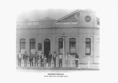 Wodonga & District Historical Society Inc
Photograph - Wodonga Civic Buildings Over Time
... first Shire Hall on the corner of High and Elgin Streets in 1890... first Shire Hall on the corner of High and Elgin Streets in 1890 ...Wodonga Shire was created in 1876 when the colonial government agreed to ratepayers' petitions to have their part of the local government district severed from the Yackandandah Shire to form a new municipality. After meeting for 14 years in rented remises, in the Prince of Wales Hall, Wodonga Council built its first Shire Hall on the corner of High and Elgin Streets in 1890. The date on the façade of the building, 1876, represents the date of the formation of the Shire. In 1957 the second Shire Office was built in Woodland Grove by A.B. and M. A. Chick. These offices were considered more than adequate for future needs. The façade featured floor to ceiling windows and several different meeting rooms in addition to the council chamber, which featured an impressive “horse shoe” table. It also included a kitchen equipped with modern fittings and a President’s room. In the late 1960s the area between Hovell and Havelock Streets as far as Jack Hore Place was zoned for civic purposes. In 1969 plans for a civic centre providing a library, theatre and senior citizens’ rooms. It was opened on 22 April 1971. In 1973, the Council engaged Bruce Marshall to design new offices beside the Civic Centre. Jennings Industries were contracted to complete the offices. The Governor, Sir Henry Winneke, laid the foundation stone of the new offices on 10 March 1976. The Civic Centre was demolished in 2011 to make may for a new $10 million community and entertainment centre which opened in August 2012.These photos are significant because they depict the different buildings which have housed the centre of local government in Wodonga since its inception as an independent shire in 1876.A series of photographs depicting the different buildings used to house the Wodonga Council and Civic buildings over time.wodonga civic buildings, wodonga council, shire of wodonga, rural city of wodonga -
 Phillip Island and District Historical Society Inc.
Photographs, Rose Series, Early 20th Century
... Avenue, Cowes, near the old Shire Hall. 233-17. Black & White... Avenue, Cowes, near the old Shire Hall. 233-17. Black & White ...Part of a collection of photographs donated by Bruce Bennett. Taken from different collections: Betty Kuc collection and Wal Steer. Most are photographs taken of postcards and photos.233-08. Black & White photograph of a postcard. Cowes Pier with shed, cranes and old Moonah tree in the foreground. 233-09. Black & White photograph of a postcard. Cowes Pier looking towards the east. Beach and foreshore in the foreground. 233-10. Black & White photograph reproduction of two young ladies in swimming costumes on Cowes Beach with pier in background. 233-11. Black & White photograph of a postcard. Cowes pier and Jetty shed, showing post and rail fence around entrance to pier. Tall Moonah tree near Jetty shed. 233-12. Black & White photograph reproduction of Genesta House with "Welcome Home" sign and Union Jack flags flying. Perhaps a welcome for local ment back home from the war?? 233-13. Black & White photograph reproduction of Genesta House in Cowes, Phillip Island. 233-14. Black & White photograph reproduction of Gullifer's Corner Store on the corner of Thompson Avenue & Chapel Street, Cowes Phillip Island. 233-15. Black & Whtie photograph of a gathering at the Cenotaph in Cowes, Phillip Island. 233-16. Black & White photograph reproduction of the Butcher Shop, Thompson Avenue, Cowes, near the old Shire Hall. 233-17. Black & White photograph reproduction of the lady on the rocks at Erehwon Point. Coastal vegetation behind the beach and two boats on the sand in the distance. 233-18. Black & White photograph reproduction of the Cowes Pier with masted ship and small boat at the pier. 233-19. Black & White photograph of the Garage Tea Rooms in Thompson Avenue, Cowes, with young cypresses which were planted circa 1915.233-08. The Rose Series P659. The Pier, Cowes, Phillip Is., Victoria. 233-09. The Rose Series P658. The Pier, Cowes, Phillip Is., Victoria. 233-11. The Rose Series P672. The Pier, Cowes, Phillip Is., Victoria. 233-16. Cowes - Jan. 1938 cowes pier phillip island, cenotaph cowes phillip island, gullifer's corner store cowes phillip island, garage tea rooms cowes phillip island, genesta house, genesta guesthouse, guesthouses cowes phillip island, erehwon point, cowes, a. smith garage tea rooms cowes phillip island, butcher shop cowes phillip island, bruce bennett, betty kuc collection, wal steer collection -
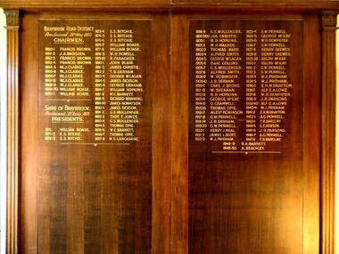 Sunshine and District Historical Society Incorporated
Honour Board, CHAIRMEN of BRAYBROOK ROAD DISTRICT 1860-1871 and PRESIDENTS of SHIRE OF BRAYBROOK 1871-1950, Unveiled 15 March 1940
... on 23rd January 1871 when the SHIRE OF BRAYBROOK came... Chamber, at the Shire of Braybrook Hall, Sunshine. The Honour ...By around circa 1850 Braybrook was already well established, and during the gold rush period also became a staging point for prospectors on their way to the diggings. Local government for the area began on 28th May 1860 when the BRAYBROOK ROAD BOARD DISTRICT was proclaimed, however this authority was soon superseded on 23rd January 1871 when the SHIRE OF BRAYBROOK came into existence. The Shire of Braybrook continued as the local government authority for the district until the CITY OF SUNSHINE was proclaimed in 1951. This Honour Board was unveiled on Monday 18th March 1940 at 8:30 p.m., and was hung in the Council Chamber, at the Shire of Braybrook Hall, Sunshine.The Honour Board is a historical record of the people who served as heads of local government in the district from 1860 to 1950.Large brown stained wooden structure comprised of two board sections positioned side by side to make one display board. Contains in gold coloured lettering the names of people who served as CHAIRMEN of the BRAYBROOK ROAD DISTRICT and as PRESIDENTS of the SHIRE OF BRAYBROOK during the years 1860 to 1950.braybrook road district, shire of braybrook, chairmen, presidents, 28 may 1860, 23 january 1871, 1950, sunshine., braybrook road district, shire of braybrook, chairmen, presidents, 28 may 1860, 23 january 1871, 1950, sunshine. -
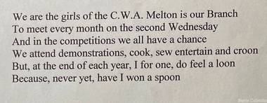 Melton City Libraries
Document, Country Women's Association Song Lyrics, c.1960
... Institute and earliest Shire Hall eastern end. Eric was grader... Institute and earliest Shire Hall eastern end. Eric was grader ...MABEL nee ABRAHAM ROGERS 1920 - 2004 Publications: The First One Hundred Years 1870-1970 Melton State School No 430 Co Author with Edna Barrie The Mechanics [Melton] 1985 Mabel Abraham was daughter of Herbert G Abraham, Butcher of High Street Melton. She attended Melton State School from 1928 qualifying for her Merit certificate in December 1928 and continued her education at Melbourne Girls High School [soon after known as MacRobertson Girls High School] She studied piano and elocution as a school girl. Mabel was associated with many activities in the Melton community. She was a natural writer and interested in research and was committed to documenting and preserving Meltons History. Mabel produced, wrote and acted for the “ Melton Amateurs” theatrical group established in 1950. The group performed Revues, Pantomimes, one and three act plays, Musical Comedy and Melodramas. In 1960 it lapsed for a time and from 1967 onwards more shows were successfully produced by Mabel. A creative producer and writer, audiences at the Melton Mechanics Institute enjoyed the performances of Gilbert and Sullivan and excerpts from the many Musicals of the era. She skilfully wrote scripts interweaving with songs and topical local dialogue successfully drawing out the talents of all the cast members. Mabel was a member of the C.W.A. holding position of Secretary. She was a member of the Melton and District Historical Society at its inception in 1968 and was a Member of The Willows Committee of Management. She was supporter of the first historical display and the Mechanics Hall and the Historical Society Annual Art and Craft shows from 1974 until 1982. In 1961 she was involved with Melton Development Association and in 1969 with the establishment of the first “Carols by Candlelight” held in Melton. Mabel was a member Anglican Church and Committee. She was a member of the Melton Mechanics Institute and made a Trustee and Life Member in 1965. She was a member of Victoria 150th Anniversary Celebration Committee. She was Guide Leader, member of the Red Cross and School Committee. In November 1982 she was a recipient of the Annual Rotary Community Service Award for outstanding service to the Community of Melton over a prolonged time. Mabel married Eric Rogers in August 1944 the wedding reception was held at the Melton Mechanics Hall. Their are children John, Ron, Francis and Judy. The family lived in High Street Melton between the Mechanics Institute and earliest Shire Hall eastern end. Eric was grader operator on the district roads. In their latter years Mabel and Eric lived in Bacchus Marsh. Eric died in Bacchus Marsh in July 2007. Country Women's Association Melton Branch lyrics from Mabel Roger's handwritten noteslocal identities, local significant groups -
 Eltham District Historical Society Inc
Photograph, Looking north across the Fitzsimons Lane Bridge over Yarra River between Eltham and Templestowe, c.1985, 1985c
... Eltham Shire hall to the Lower Heidelberg Road-Banksia Street... Eltham Shire hall to the Lower Heidelberg Road-Banksia Street ...Turnoff to Candlebark Park on right. The bridge over the Yarra River was initially opened September 22nd, 1961. Newspaper reports at the time of opening stated it linked Bolton Street, Eltham, with Fitzsimons Lane, Templestowe. In 1955 the Country Roads Board (CRB) produced survey plans that showed proposed land acquisition for the future bridge and road approaches. The 1955 plan shows that it was proposed to connect Fitzsimons Lane with Bolton Street in Eltham by a diagonal road across the river. The road connection would then continue along Bolton Street to Main Road. Prior to construction of the bridge the CRB modified the proposal significantly so that there was a new road parallel with Bolton Street and then curving to join Main Road at what was then its intersection with Old Eltham Road. This involved significantly more land acquisition and altered the pattern of land subdivision through this corridor. Initially the new road was just a single two-way carriageway as it would have required a significant widening of the cutting on the Shire of Eltham side of the river. The road was officially un-named but was known locally as the Eltham-Templestowe Road. The 1966 Melway street directory and other 1960s editions also listed the road as the Eltham-Templestowe Road. In December 1970, Eltham Shire Council, in pursuance of the provisions of the Local Government Act, named it Templestowe Road. The road was renamed Fitzsimons Lane around 1984 in conformity with the section south of the river. In 1991 a new bridge was built to the west of the original bridge. Fitzsimons Lane was widened to four traffic lanes although on the Eltham side this was done within the limits of the existing cutting. NEW BRIDGE STARTS THEM EXPLORING Without any fanfares, Country Roads Board workmen on Friday afternoon put the finishing touches to the approaches, removed the barricades, and let the traffic roll over the new Yarra bridge linking Bolton Street, Eltham, with Fitzsimons Lane, Templestowe. Over the week-end many “bridge watchers” who were making one of their periodic inspections of the progress on the new bridge found to their surprise that they could drive over it, so that people who had gone for a run out to Eltham suddenly found themselves wandering through Templestowe and Doncaster. By Monday the word of the bridge’s opening had got around sufficiently for many regular travellers to the city from Eltham and beyond to vary the monotony by going to town via Templestowe and Kew instead of through Heidelberg. They were surprised at the distances – about 3 ½ miles from Eltham to Templestowe, 6 miles from Eltham Shire hall to the Lower Heidelberg Road-Banksia Street intersection. NEW NEIGHBOURS For people on both sides of the river, the new bridge has turned distant friends into near neighbours. A Greensborough man on Sunday took 35 minutes to reach the home of a friend in East Doncaster, but the return trip over the new bridge took only 17 minutes. It will be some time yet before most people work out the possibilities in shorter and quicker trips form the north-eastern areas to the eastern and south-eastern suburbs. The coming of the warmer months will soon teach many, though the short cuts to Peninsular beaches and eastern suburban drive-ins. And before very long it is likely there will be a Tramways bus running from Templestowe to Eltham station. NEW BRIDGE STARTS THEM EXPLORING (1961, September 27). The Diamond Valley News (News clipping held in SEA_74-1_047) The previously un-named road between Main Road and Yarra River, Eltham South, east of Bolton Street was named Templestowe Road, December 15, 1970 NAMING OF STREETS AND ROADS. (1970, December 15). The Diamond Valley News (News clipping held in SEA_74-2_022)Colour photographinfrastructure, shire of eltham infrastructure, bridge, fitzsimons lane bridge, yarra river, candlebark park, red nose day -
 Eltham District Historical Society Inc
Photograph, Fitzsimons Lane Bridge over Yarra River between Eltham and Templestowe
... Eltham Shire hall to the Lower Heidelberg Road-Banksia Street... Eltham Shire hall to the Lower Heidelberg Road-Banksia Street ...The bridge over the Yarra River was initially opened September 22nd, 1961. Newspaper reports at the time of opening stated it linked Bolton Street, Eltham, with Fitzsimons Lane, Templestowe. In 1955 the Country Roads Board (CRB) produced survey plans that showed proposed land acquisition for the future bridge and road approaches. The 1955 plan shows that it was proposed to connect Fitzsimons Lane with Bolton Street in Eltham by a diagonal road across the river. The road connection would then continue along Bolton Street to Main Road. Prior to construction of the bridge the CRB modified the proposal significantly so that there was a new road parallel with Bolton Street and then curving to join Main Road at what was then its intersection with Old Eltham Road. This involved significantly more land acquisition and altered the pattern of land subdivision through this corridor. Initially the new road was just a single two-way carriageway as it would have required a significant widening of the cutting on the Shire of Eltham side of the river. The road was officially un-named but was known locally as the Eltham-Templestowe Road. The 1966 Melway street directory and other 1960s editions also listed the road as the Eltham-Templestowe Road. In December 1970, Eltham Shire Council, in pursuance of the provisions of the Local Government Act, named it Templestowe Road. The road was renamed Fitzsimons Lane around 1984 in conformity with the section south of the river. In 1991 a new bridge was built to the west of the original bridge. Fitzsimons Lane was widened to four traffic lanes although on the Eltham side this was done within the limits of the existing cutting. NEW BRIDGE STARTS THEM EXPLORING Without any fanfares, Country Roads Board workmen on Friday afternoon put the finishing touches to the approaches, removed the barricades, and let the traffic roll over the new Yarra bridge linking Bolton Street, Eltham, with Fitzsimons Lane, Templestowe. Over the week-end many “bridge watchers” who were making one of their periodic inspections of the progress on the new bridge found to their surprise that they could drive over it, so that people who had gone for a run out to Eltham suddenly found themselves wandering through Templestowe and Doncaster. By Monday the word of the bridge’s opening had got around sufficiently for many regular travellers to the city from Eltham and beyond to vary the monotony by going to town via Templestowe and Kew instead of through Heidelberg. They were surprised at the distances – about 3 ½ miles from Eltham to Templestowe, 6 miles from Eltham Shire hall to the Lower Heidelberg Road-Banksia Street intersection. NEW NEIGHBOURS For people on both sides of the river, the new bridge has turned distant friends into near neighbours. A Greensborough man on Sunday took 35 minutes to reach the home of a friend in East Doncaster, but the return trip over the new bridge took only 17 minutes. It will be some time yet before most people work out the possibilities in shorter and quicker trips form the north-eastern areas to the eastern and south-eastern suburbs. The coming of the warmer months will soon teach many, though the short cuts to Peninsular beaches and eastern suburban drive-ins. And before very long it is likely there will be a Tramways bus running from Templestowe to Eltham station. NEW BRIDGE STARTS THEM EXPLORING (1961, September 27). The Diamond Valley News (News clipping held in SEA_74-1_047) The previously un-named road between Main Road and Yarra River, Eltham South, east of Bolton Street was named Templestowe Road, December 15, 1970 NAMING OF STREETS AND ROADS. (1970, December 15). The Diamond Valley News (News clipping held in SEA_74-2_022)Black and white photographinfrastructure, shire of eltham infrastructure, bridge, fitzsimons lane bridge, yarra river -
 Eltham District Historical Society Inc
Photograph, Looking south across the Fitzsimons Lane Bridge over Yarra River between Eltham and Templestowe
... Eltham Shire hall to the Lower Heidelberg Road-Banksia Street... Eltham Shire hall to the Lower Heidelberg Road-Banksia Street ...The bridge over the Yarra River was initially opened September 22nd, 1961. Newspaper reports at the time of opening stated it linked Bolton Street, Eltham, with Fitzsimons Lane, Templestowe. In 1955 the Country Roads Board (CRB) produced survey plans that showed proposed land acquisition for the future bridge and road approaches. The 1955 plan shows that it was proposed to connect Fitzsimons Lane with Bolton Street in Eltham by a diagonal road across the river. The road connection would then continue along Bolton Street to Main Road. Prior to construction of the bridge the CRB modified the proposal significantly so that there was a new road parallel with Bolton Street and then curving to join Main Road at what was then its intersection with Old Eltham Road. This involved significantly more land acquisition and altered the pattern of land subdivision through this corridor. Initially the new road was just a single two-way carriageway as it would have required a significant widening of the cutting on the Shire of Eltham side of the river. The road was officially un-named but was known locally as the Eltham-Templestowe Road. The 1966 Melway street directory and other 1960s editions also listed the road as the Eltham-Templestowe Road. In December 1970, Eltham Shire Council, in pursuance of the provisions of the Local Government Act, named it Templestowe Road. The road was renamed Fitzsimons Lane around 1984 in conformity with the section south of the river. In 1991 a new bridge was built to the west of the original bridge. Fitzsimons Lane was widened to four traffic lanes although on the Eltham side this was done within the limits of the existing cutting. NEW BRIDGE STARTS THEM EXPLORING Without any fanfares, Country Roads Board workmen on Friday afternoon put the finishing touches to the approaches, removed the barricades, and let the traffic roll over the new Yarra bridge linking Bolton Street, Eltham, with Fitzsimons Lane, Templestowe. Over the week-end many “bridge watchers” who were making one of their periodic inspections of the progress on the new bridge found to their surprise that they could drive over it, so that people who had gone for a run out to Eltham suddenly found themselves wandering through Templestowe and Doncaster. By Monday the word of the bridge’s opening had got around sufficiently for many regular travellers to the city from Eltham and beyond to vary the monotony by going to town via Templestowe and Kew instead of through Heidelberg. They were surprised at the distances – about 3 ½ miles from Eltham to Templestowe, 6 miles from Eltham Shire hall to the Lower Heidelberg Road-Banksia Street intersection. NEW NEIGHBOURS For people on both sides of the river, the new bridge has turned distant friends into near neighbours. A Greensborough man on Sunday took 35 minutes to reach the home of a friend in East Doncaster, but the return trip over the new bridge took only 17 minutes. It will be some time yet before most people work out the possibilities in shorter and quicker trips form the north-eastern areas to the eastern and south-eastern suburbs. The coming of the warmer months will soon teach many, though the short cuts to Peninsular beaches and eastern suburban drive-ins. And before very long it is likely there will be a Tramways bus running from Templestowe to Eltham station. NEW BRIDGE STARTS THEM EXPLORING (1961, September 27). The Diamond Valley News (News clipping held in SEA_74-1_047) The previously un-named road between Main Road and Yarra River, Eltham South, east of Bolton Street was named Templestowe Road, December 15, 1970 NAMING OF STREETS AND ROADS. (1970, December 15). The Diamond Valley News (News clipping held in SEA_74-2_022)Black and white photographinfrastructure, shire of eltham infrastructure, bridge, fitzsimons lane bridge, yarra river -
 Eltham District Historical Society Inc
Photograph, Fitzsimons Lane Bridge over Yarra River between Eltham and Templestowe
... Eltham Shire hall to the Lower Heidelberg Road-Banksia Street... Eltham Shire hall to the Lower Heidelberg Road-Banksia Street ...The bridge over the Yarra River was initially opened September 22nd, 1961. Newspaper reports at the time of opening stated it linked Bolton Street, Eltham, with Fitzsimons Lane, Templestowe. In 1955 the Country Roads Board (CRB) produced survey plans that showed proposed land acquisition for the future bridge and road approaches. The 1955 plan shows that it was proposed to connect Fitzsimons Lane with Bolton Street in Eltham by a diagonal road across the river. The road connection would then continue along Bolton Street to Main Road. Prior to construction of the bridge the CRB modified the proposal significantly so that there was a new road parallel with Bolton Street and then curving to join Main Road at what was then its intersection with Old Eltham Road. This involved significantly more land acquisition and altered the pattern of land subdivision through this corridor. Initially the new road was just a single two-way carriageway as it would have required a significant widening of the cutting on the Shire of Eltham side of the river. The road was officially un-named but was known locally as the Eltham-Templestowe Road. The 1966 Melway street directory and other 1960s editions also listed the road as the Eltham-Templestowe Road. In December 1970, Eltham Shire Council, in pursuance of the provisions of the Local Government Act, named it Templestowe Road. The road was renamed Fitzsimons Lane around 1984 in conformity with the section south of the river. In 1991 a new bridge was built to the west of the original bridge. Fitzsimons Lane was widened to four traffic lanes although on the Eltham side this was done within the limits of the existing cutting. NEW BRIDGE STARTS THEM EXPLORING Without any fanfares, Country Roads Board workmen on Friday afternoon put the finishing touches to the approaches, removed the barricades, and let the traffic roll over the new Yarra bridge linking Bolton Street, Eltham, with Fitzsimons Lane, Templestowe. Over the week-end many “bridge watchers” who were making one of their periodic inspections of the progress on the new bridge found to their surprise that they could drive over it, so that people who had gone for a run out to Eltham suddenly found themselves wandering through Templestowe and Doncaster. By Monday the word of the bridge’s opening had got around sufficiently for many regular travellers to the city from Eltham and beyond to vary the monotony by going to town via Templestowe and Kew instead of through Heidelberg. They were surprised at the distances – about 3 ½ miles from Eltham to Templestowe, 6 miles from Eltham Shire hall to the Lower Heidelberg Road-Banksia Street intersection. NEW NEIGHBOURS For people on both sides of the river, the new bridge has turned distant friends into near neighbours. A Greensborough man on Sunday took 35 minutes to reach the home of a friend in East Doncaster, but the return trip over the new bridge took only 17 minutes. It will be some time yet before most people work out the possibilities in shorter and quicker trips form the north-eastern areas to the eastern and south-eastern suburbs. The coming of the warmer months will soon teach many, though the short cuts to Peninsular beaches and eastern suburban drive-ins. And before very long it is likely there will be a Tramways bus running from Templestowe to Eltham station. NEW BRIDGE STARTS THEM EXPLORING (1961, September 27). The Diamond Valley News (News clipping held in SEA_74-1_047) The previously un-named road between Main Road and Yarra River, Eltham South, east of Bolton Street was named Templestowe Road, December 15, 1970 NAMING OF STREETS AND ROADS. (1970, December 15). The Diamond Valley News (News clipping held in SEA_74-2_022)Black and white photographinfrastructure, shire of eltham infrastructure, bridge, fitzsimons lane bridge, yarra river -
 Eltham District Historical Society Inc
Photograph, Russell Yeoman, Fitzsimons Lane Bridge over Yarra River between Eltham and Templestowe, c.1970, 1970c
... Eltham Shire hall to the Lower Heidelberg Road-Banksia Street... Eltham Shire hall to the Lower Heidelberg Road-Banksia Street ...The bridge over the Yarra River was initially opened September 22nd, 1961. Newspaper reports at the time of opening stated it linked Bolton Street, Eltham, with Fitzsimons Lane, Templestowe. In 1955 the Country Roads Board (CRB) produced survey plans that showed proposed land acquisition for the future bridge and road approaches. The 1955 plan shows that it was proposed to connect Fitzsimons Lane with Bolton Street in Eltham by a diagonal road across the river. The road connection would then continue along Bolton Street to Main Road. Prior to construction of the bridge the CRB modified the proposal significantly so that there was a new road parallel with Bolton Street and then curving to join Main Road at what was then its intersection with Old Eltham Road. This involved significantly more land acquisition and altered the pattern of land subdivision through this corridor. Initially the new road was just a single two-way carriageway as it would have required a significant widening of the cutting on the Shire of Eltham side of the river. The road was officially un-named but was known locally as the Eltham-Templestowe Road. The 1966 Melway street directory and other 1960s editions also listed the road as the Eltham-Templestowe Road. In December 1970, Eltham Shire Council, in pursuance of the provisions of the Local Government Act, named it Templestowe Road. The road was renamed Fitzsimons Lane around 1984 in conformity with the section south of the river. In 1991 a new bridge was built to the west of the original bridge. Fitzsimons Lane was widened to four traffic lanes although on the Eltham side this was done within the limits of the existing cutting. NEW BRIDGE STARTS THEM EXPLORING Without any fanfares, Country Roads Board workmen on Friday afternoon put the finishing touches to the approaches, removed the barricades, and let the traffic roll over the new Yarra bridge linking Bolton Street, Eltham, with Fitzsimons Lane, Templestowe. Over the week-end many “bridge watchers” who were making one of their periodic inspections of the progress on the new bridge found to their surprise that they could drive over it, so that people who had gone for a run out to Eltham suddenly found themselves wandering through Templestowe and Doncaster. By Monday the word of the bridge’s opening had got around sufficiently for many regular travellers to the city from Eltham and beyond to vary the monotony by going to town via Templestowe and Kew instead of through Heidelberg. They were surprised at the distances – about 3 ½ miles from Eltham to Templestowe, 6 miles from Eltham Shire hall to the Lower Heidelberg Road-Banksia Street intersection. NEW NEIGHBOURS For people on both sides of the river, the new bridge has turned distant friends into near neighbours. A Greensborough man on Sunday took 35 minutes to reach the home of a friend in East Doncaster, but the return trip over the new bridge took only 17 minutes. It will be some time yet before most people work out the possibilities in shorter and quicker trips form the north-eastern areas to the eastern and south-eastern suburbs. The coming of the warmer months will soon teach many, though the short cuts to Peninsular beaches and eastern suburban drive-ins. And before very long it is likely there will be a Tramways bus running from Templestowe to Eltham station. NEW BRIDGE STARTS THEM EXPLORING (1961, September 27). The Diamond Valley News (News clipping held in SEA_74-1_047) The previously un-named road between Main Road and Yarra River, Eltham South, east of Bolton Street was named Templestowe Road, December 15, 1970 NAMING OF STREETS AND ROADS. (1970, December 15). The Diamond Valley News (News clipping held in SEA_74-2_022)Roll of 35mm black and white negative film, 4 of 7 stripsIlford HP4bridge, bridges, fitzsimons lane bridge, infrastructure, shire of eltham infrastructure, yarra river -
 Eltham District Historical Society Inc
Photograph, Fitzsimons Lane Bridge over Yarra River between Eltham and Templestowe, c.1966, 1966c
... Eltham Shire hall to the Lower Heidelberg Road-Banksia Street... Eltham Shire hall to the Lower Heidelberg Road-Banksia Street ...The bridge over the Yarra River was initially opened September 22nd, 1961. Newspaper reports at the time of opening stated it linked Bolton Street, Eltham, with Fitzsimons Lane, Templestowe. In 1955 the Country Roads Board (CRB) produced survey plans that showed proposed land acquisition for the future bridge and road approaches. The 1955 plan shows that it was proposed to connect Fitzsimons Lane with Bolton Street in Eltham by a diagonal road across the river. The road connection would then continue along Bolton Street to Main Road. Prior to construction of the bridge the CRB modified the proposal significantly so that there was a new road parallel with Bolton Street and then curving to join Main Road at what was then its intersection with Old Eltham Road. This involved significantly more land acquisition and altered the pattern of land subdivision through this corridor. Initially the new road was just a single two-way carriageway as it would have required a significant widening of the cutting on the Shire of Eltham side of the river. The road was officially un-named but was known locally as the Eltham-Templestowe Road. The 1966 Melway street directory and other 1960s editions also listed the road as the Eltham-Templestowe Road. In December 1970, Eltham Shire Council, in pursuance of the provisions of the Local Government Act, named it Templestowe Road. The road was renamed Fitzsimons Lane around 1984 in conformity with the section south of the river. In 1991 a new bridge was built to the west of the original bridge. Fitzsimons Lane was widened to four traffic lanes although on the Eltham side this was done within the limits of the existing cutting. NEW BRIDGE STARTS THEM EXPLORING Without any fanfares, Country Roads Board workmen on Friday afternoon put the finishing touches to the approaches, removed the barricades, and let the traffic roll over the new Yarra bridge linking Bolton Street, Eltham, with Fitzsimons Lane, Templestowe. Over the week-end many “bridge watchers” who were making one of their periodic inspections of the progress on the new bridge found to their surprise that they could drive over it, so that people who had gone for a run out to Eltham suddenly found themselves wandering through Templestowe and Doncaster. By Monday the word of the bridge’s opening had got around sufficiently for many regular travellers to the city from Eltham and beyond to vary the monotony by going to town via Templestowe and Kew instead of through Heidelberg. They were surprised at the distances – about 3 ½ miles from Eltham to Templestowe, 6 miles from Eltham Shire hall to the Lower Heidelberg Road-Banksia Street intersection. NEW NEIGHBOURS For people on both sides of the river, the new bridge has turned distant friends into near neighbours. A Greensborough man on Sunday took 35 minutes to reach the home of a friend in East Doncaster, but the return trip over the new bridge took only 17 minutes. It will be some time yet before most people work out the possibilities in shorter and quicker trips form the north-eastern areas to the eastern and south-eastern suburbs. The coming of the warmer months will soon teach many, though the short cuts to Peninsular beaches and eastern suburban drive-ins. And before very long it is likely there will be a Tramways bus running from Templestowe to Eltham station. NEW BRIDGE STARTS THEM EXPLORING (1961, September 27). The Diamond Valley News (News clipping held in SEA_74-1_047) The previously un-named road between Main Road and Yarra River, Eltham South, east of Bolton Street was named Templestowe Road, December 15, 1970 NAMING OF STREETS AND ROADS. (1970, December 15). The Diamond Valley News (News clipping held in SEA_74-2_022)Black and white photographManufacturer's marks: Polaroid, Batch #J62K181 (Sep 1966).infrastructure, shire of eltham infrastructure, bridge, fitzsimons lane bridge, polaroid, yarra river -
 Eltham District Historical Society Inc
Photograph, Fitzsimons Lane Bridge over Yarra River between Eltham and Templestowe
... Eltham Shire hall to the Lower Heidelberg Road-Banksia Street... Eltham Shire hall to the Lower Heidelberg Road-Banksia Street ...The bridge over the Yarra River was initially opened September 22nd, 1961. Newspaper reports at the time of opening stated it linked Bolton Street, Eltham, with Fitzsimons Lane, Templestowe. In 1955 the Country Roads Board (CRB) produced survey plans that showed proposed land acquisition for the future bridge and road approaches. The 1955 plan shows that it was proposed to connect Fitzsimons Lane with Bolton Street in Eltham by a diagonal road across the river. The road connection would then continue along Bolton Street to Main Road. Prior to construction of the bridge the CRB modified the proposal significantly so that there was a new road parallel with Bolton Street and then curving to join Main Road at what was then its intersection with Old Eltham Road. This involved significantly more land acquisition and altered the pattern of land subdivision through this corridor. Initially the new road was just a single two-way carriageway as it would have required a significant widening of the cutting on the Shire of Eltham side of the river. The road was officially un-named but was known locally as the Eltham-Templestowe Road. The 1966 Melway street directory and other 1960s editions also listed the road as the Eltham-Templestowe Road. In December 1970, Eltham Shire Council, in pursuance of the provisions of the Local Government Act, named it Templestowe Road. The road was renamed Fitzsimons Lane around 1984 in conformity with the section south of the river. In 1991 a new bridge was built to the west of the original bridge. Fitzsimons Lane was widened to four traffic lanes although on the Eltham side this was done within the limits of the existing cutting. NEW BRIDGE STARTS THEM EXPLORING Without any fanfares, Country Roads Board workmen on Friday afternoon put the finishing touches to the approaches, removed the barricades, and let the traffic roll over the new Yarra bridge linking Bolton Street, Eltham, with Fitzsimons Lane, Templestowe. Over the week-end many “bridge watchers” who were making one of their periodic inspections of the progress on the new bridge found to their surprise that they could drive over it, so that people who had gone for a run out to Eltham suddenly found themselves wandering through Templestowe and Doncaster. By Monday the word of the bridge’s opening had got around sufficiently for many regular travellers to the city from Eltham and beyond to vary the monotony by going to town via Templestowe and Kew instead of through Heidelberg. They were surprised at the distances – about 3 ½ miles from Eltham to Templestowe, 6 miles from Eltham Shire hall to the Lower Heidelberg Road-Banksia Street intersection. NEW NEIGHBOURS For people on both sides of the river, the new bridge has turned distant friends into near neighbours. A Greensborough man on Sunday took 35 minutes to reach the home of a friend in East Doncaster, but the return trip over the new bridge took only 17 minutes. It will be some time yet before most people work out the possibilities in shorter and quicker trips form the north-eastern areas to the eastern and south-eastern suburbs. The coming of the warmer months will soon teach many, though the short cuts to Peninsular beaches and eastern suburban drive-ins. And before very long it is likely there will be a Tramways bus running from Templestowe to Eltham station. NEW BRIDGE STARTS THEM EXPLORING (1961, September 27). The Diamond Valley News (News clipping held in SEA_74-1_047) The previously un-named road between Main Road and Yarra River, Eltham South, east of Bolton Street was named Templestowe Road, December 15, 1970 NAMING OF STREETS AND ROADS. (1970, December 15). The Diamond Valley News (News clipping held in SEA_74-2_022)Black and white photographinfrastructure, shire of eltham infrastructure, bridge, fitzsimons lane bridge, yarra river -
 Eltham District Historical Society Inc
Document, Conveyance of Lot 20 Henry Street, Little Eltham North to Trustees of Wesleyan Chapel, 1856
... with the new Shire Offices and Hall built on the corner of Arthur... with the new Shire Offices and Hall built on the corner of Arthur ...Originally purchased in 1856 from Thomas Roberts, Yeoman of Little Eltham, for £10 for use by the Wesleyan Chapel, represented by indentured Trustees, Rev. Barnabas Shaw Walker, Minister of the Pentridge Circuit, Francis Thomas, Farmer of Keelbundora, William Harriman, Blacksmith of Nillumbik, Nicholas Rodda, Farmer of Nillumbik, Aaron Grimshaw, Farmer of Greensborough, Joseph Cooper, Gardener of Keelbundora, Peter Dredge, Scholmaster of Jika Jika and Samuel Jeffrey, Farmer of Jika Jika. Lot 20 of Subdivision of Portion 13, Section 4 of the Parish of Nillumbik in the County of Evelyn was located on the southern side of Henry street in Little Eltham North, where the current Our Lady Help of Christians Catholic Church is situated. It became the location of the Eltham Rechabite Hall. In 1893 a new hall was built and further enlarged in 1919. At the commencement of 1922, the property was purchased from the Independent Order of Rechabites with publicly subscribed funds and a new hall built at a cost of £750 and improved road access constructed to reduce the grade, running from Dudley Street to Henry Street. This hall was eventually replaced with the new Shire Offices and Hall built on the corner of Arthur Street and Main Road, which was opened in 1941. Traces the earliest history of the Eltham Public Hall in Henry Street and the various names, occupations and abodes of the Trustees associated with the propertyaaron grimshaw, blacksmith, edmond perry, eltham public hall, eltham rechabite hall, eltham wesleyan chapel, francis thomas, george smith, henry street, i.w. lucas, james blanch, james chapman, james william brown, john jenkins peacock, john jones, john neale, john van mangerhoussen weiss, joseph cooper, joseph morris holloway, josiah atwool, keelbundora, lancelot iredale, little eltham, lizar elliott, mark blanchard, methodist church, nicholas rodda, p. mather, peter dredge, rev barnabas shaw walker, samuel jeffrey, samuel moor munce, thomas roberts, thomas wheaten bowden, william harriman, william hebblewhite, william john munce, william matthews, william rose -
 Melton City Libraries
Letter, Letter from Margaret B Gibson, 1928/2014
... Church Melton. The old school, the Shire Hall, many private... Melton. The old school, the Shire Hall, many private dwellings ...David McKenzie obituary, Romsey Examiner 1928 Another of Australia’s very old pioneers in the person of Mr McKenzie, passed away last weekend at his daughters residence At regent at the ripe old age of 92 years ( he would be 93 in November) Born at Berwick of Tweed Scotland, the late Mr McKenzie arrived in Australia with two of his uncles in 1855 by the ship “Red Jacket”. A stone- mason by trade he worked about Melbourne and at Geelong until attack by “gold fever” but met with no success at this venture so he returned to his trade, arriving at Melton about 1860. There he married and settles for about 20 years. In 1880 the Cherokee Heights with its subdivision was famous and Mr McKenzie moved there with his daughter. He continues in his trade, his work extending to Gisborne, Bacchus Marsh, Romsey, and Springfield and other places, where to this day, may be seen monuments of his skill and through tradesmanship as a mason. During his residence in the Mount, he took a keen interest in all the affairs of Kerrie and Cherokee, and he was a familiar figure at all the public gatherings at which he nearly always filled the position of Chairman, because of outstanding qualifications. He was a man of those sterling qualities possessed by those men who laid the foundation of this country so well and truly. Loyal, broad of vision, just in thought and deed, honourable to the extreme in all dealings, fearless in the cause of right, a lover of home and family, and ready to lend a hand to all progressive movements. To the memory of those grand men the youth of today should lift their hats in reverence. Mr McKenzie was a prolific reader of educational works, and the wonderful knowledge he retained upon a variety of subjects was a source joy to those who associated with him. His wife predeceased him by 43 years ago soon after arrival in Cherokee. A Pioneer of Melton There are probably some residents left at Melton and Bacchus Marsh who will remember the late Mr McKenzie, one of them has written as follows:- I knew the late Mr. McKenzie since I was a little boy – over 50 years ago- and no better man ever lived than he, he was a good man from every point of view. The late Mr McKenzie was born on the November 25th, 1835 at Montrose, Scotland. He came to Australia in 1853 and resided for a time with his uncle the late Mr. Gibson on the Kororoit Creek near Melton. A few years later he settled in Melton. In 1861 he was married to Miss Mary Buchanan, the eldest daughter of the late Mr. George Buchanan, one of the early settlers of Melton. Deceased resided on the main road to Bacchus Marsh one mile from Melton. He was a stone- mason by trade, and some fine buildings in Melton and surrounding districts to this day, stand to his credit. He built the Presbyterian Church Melton. The old school, the Shire Hall, many private dwellings and numerous bridges. He was highly respected, as he was well known for the good work he put into all he had to do with. He also took numerous contracts in the Melton Shire, and was also employed by the Shire as Clerk of Works. He was a most conscious man. In his day he took a prominent part in all public affairs, and was a leading spirit in the old school Board. He was one of the pioneers of the Melton Rechabite Tent. He was one of the earliest workers and supporters of the Melton Presbyterian Church, of which he was an elder, and for a great number of years, its Sunday School Superintendent and Teacher. He also lead the singing for many years before the days of the organ, as he had a splendid voice, and could sing his old Scotch songs and hymns up to within six months of his death. For the past five years he has resided with one of his daughters at north Preston, where he died. He had good health up to within six months of his death and could well remember all the early happenings at Melton and surrounding districts. There are five daughters and one living son:- Margaret Mrs. Walter Wyatt Twose of Burnley Elizabeth Mrs George Shebler of Brunswick Georgina Mrs Jack Sinclair Isabel Mrs H Knight of North Preston Jane Mrs William Gibson of Warragul John W. of Fremantle - Western Australia Letter from Margaret to the Melton Presbyterian Churchchurches, local architecture -
 Eltham District Historical Society Inc
Document, Certificate as to Trustees of Wesleyan Church land, Lot 20 Henry Street, Little Eltham North, 7 Oct 1901
... with the new Shire Offices and Hall built on the corner of Arthur... with the new Shire Offices and Hall built on the corner of Arthur ...The Trustees for Lot 20 Henry Street were declared by the Wesleyan Methodist Church on 7 October 1901 to be Revd. Barnabas Shaw Walker, Minister of the Pentridge Circuit, Joseph Cooper, Gardener of Keelbundora, Samuel Jeffrey, Farmer of Jika Jika, Francis Thomas, Farmer of Doncaster and sometime of Keelbundora, John Brown, State School Teacher, William John Taylor, Gardener, Robert David Taylor, Gardener and Isaac Hill, Dealer, all of Eltham. Originally purchased in 1856 from Thomas Roberts, Yeoman of Little Eltham, for £10 for use by the Wesleyan Chapel, represented by indentured Trustees, Rev. Barnabas Shaw Walker, Minister of the Pentridge Circuit, Francis Thomas, Farmer of Keelbundora, William Harriman, Blacksmith of Nillumbik, Nicholas Rodda, Farmer of Nillumbik, Aaron Grimshaw, Farmer of Greensborough, Joseph Cooper, Gardener of Keelbundora, Peter Dredge, Scholmaster of Jika Jika and Samuel Jeffrey, Farmer of Jika Jika. Lot 20 of Subdivision of Portion 13, Section 4 of the Parish of Nillumbik in the County of Evelyn was located on the southern side of Henry street in Little Eltham North, where the current Our Lady Help of Christians Catholic Church is situated. It became the location of the Eltham Rechabite Hall. In 1893 a new hall was built and further enlarged in 1919. At the commencement of 1922, the property was purchased from the Independent Order of Rechabites with publicly subscribed funds and a new hall built at a cost of £750 and improved road access constructed to reduce the grade, running from Dudley Street to Henry Street. This hall was eventually replaced with the new Shire Offices and Hall built on the corner of Arthur Street and Main Road, which was opened in 1941. Traces the earliest history of the Eltham Public Hall in Henry Street and the various names, occupations and abodes of the Trustees associated with the propertyeltham public hall, eltham rechabite hall, eltham wesleyan chapel, francis thomas, henry street, james abel marsland, james massland, john brown, joseph cooper, little eltham north, rev barnabas shaw walker, robert david taylor, samuel jeffrey, trustee, william john taylor, little eltham, isaac hill -
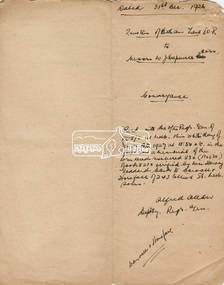 Eltham District Historical Society Inc
Document, Conveyance, Lot 20 Henry Street, Eltham, Hope of Eltham Tent No. 195 I.O.R. to W.J. Capewell and others, 31 Dec 1926
... with the new Shire Offices and Hall built on the corner of Arthur... with the new Shire Offices and Hall built on the corner of Arthur ...Indenture between Jack Alfred Harrison, Accountant, Edward Samuel McColl, Council Employee, both of Eltham and William Wilson, Coachbuilder of Research, the Trustees of a certain Friendly Society known as The Hope of Eltham Tent No. 195 Victorian District I.O.R of the one part and William James Capewell, Butcher, Ernest James Andrew, News Agent and George Birchall, Hatter all of Eltham of the other part, Trustees for The Eltham Hall, for the purchase of Lot 20 Henry Street for £750. Witnessed by Hubert James Carter J.P for Jack Alfred Harrison, A.H.C. Price J.P. for Edward Samuel McColl and J. Webster J.P. for William Wilson. Originally purchased in 1856 from Thomas Roberts, Yeoman of Little Eltham, for £10 for use by the Wesleyan Chapel, represented by indentured Trustees, Rev. Barnabas Shaw Walker, Minister of the Pentridge Circuit, Francis Thomas, Farmer of Keelbundora, William Harriman, Blacksmith of Nillumbik, Nicholas Rodda, Farmer of Nillumbik, Aaron Grimshaw, Farmer of Greensborough, Joseph Cooper, Gardener of Keelbundora, Peter Dredge, Scholmaster of Jika Jika and Samuel Jeffrey, Farmer of Jika Jika. Lot 20 of Subdivision of Portion 13, Section 4 of the Parish of Nillumbik in the County of Evelyn was located on the southern side of Henry street in Little Eltham North, where the current Our Lady Help of Christians Catholic Church is situated. It became the location of the Eltham Rechabite Hall. In 1893 a new hall was built and further enlarged in 1919. At the commencement of 1922, the property was purchased from the Independent Order of Rechabites with publicly subscribed funds and a new hall built at a cost of £750 and improved road access constructed to reduce the grade, running from Dudley Street to Henry Street. This hall was eventually replaced with the new Shire Offices and Hall built on the corner of Arthur Street and Main Road, which was opened in 1941. Traces the earliest history of the Eltham Public Hall in Henry Street and the various names, occupations and abodes of the Trustees associated with the property