Showing 5607 items matching " suburbs"
-
 Ambulance Victoria Museum
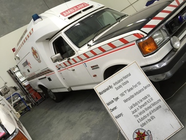
Vehicle, motor, Ambulance, Ford 150, F series, 1992, 1992
This vehicle is a Ford 150 F Series, manufactured in 1992. It is the last body to be fitted out as an ambulance by Jacab in Tamworth , New South Wales. This vehicle was owned by the Metropolitan Ambulance Service and serviced Melbourne and surrounding suburbs on all ambulance duties in the 1990's. Four-wheeled Motor vehicle fitted out as an ambulance. Bodywork painted white with red logo and markings. Bonnet painted grey. Bumpers are chrome. Red and blue lights mounted on roof above front windscreen. Red light mounted above rear windscreen.Registration number EYH837. There is a strip of red and white diagonal striping along the sides and at the front of the vehicle. Logo ...........ADD MOREambulance, motor vehicle, ford, ford f150 series f, jacab, melbourne, metropolitan ambulance service, tamworth -
 Kew Historical Society Inc
Plan - Subdivision Plan, Windella-Darnley Subdivision, Studley Park, 1920s
Subdivision plans are historically important documents used as evidence of the growth of suburbs in Australia. They frequently provide information about when the land was sold on which a built structure was subsequently constructed as well as evidence relating to surveyors and real estate and financial agents. The numerous subdivision plans in the Kew Historical Society's collection represent working documents, ranging from the initial sketches made in planning a subdivision to printed plans on which auctioneers or agents listed the prices for which individual lots were sold. In a number of cases, the reverse of a subdivision plan in the collection includes a photograph of a house that was also for sale by the agent. These photographs provide significant heritage information relating house design and decoration, fencing and household gardens.Version 2 of two subdivision plans (the earlier is 2016.0305.1) for the section of Studley Park Road near the Junction on the south side. Named in the subdivision are the mansions of Darley and Windella (now demolished). Before the subdivision of Darley and Windella, both houses fronted Studley Park Road. Both houses appear to be advertised as lots in the subdivision. Bisecting the subdivision is a street, Antrim Avenue that was never constructed. A street, which was subsequently constructed in this vicinity, was Merrion Place, which now runs between Studley Park Road and Highfield Grove. There are 13 proposed lots in this subdivision in contrast to the earlier plan. This resulted from larger lots being proposed for Studley Park Road.subdivision plans - kew, studley park, windella, darnley, antrim avenue -- kew (vic.), studley park road -- kew (vic.), merrion place -- kew (vic.), merrion grove -- kew (vic.), highbury grove -- kew (vic.) -
 Royal District Nursing Service (now known as Bolton Clarke)
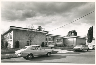
Photograph - Digital image, Barry Sutton, 12.07.1972
The photograph is taken outside the new Royal District Nursing Service (RDNS) Caulfield Centre. RDNS Sisters left in RDNS Torana vehicles from this Centre each morning to give nursing care to patients in surrounding suburbs and returned to the Centre after their visits. Gradually over the years, Melbourne District Nursing Service (MDNS), later known as Royal District Nursing Service (RDNS) from 1966 when they received Royal patronage, opened Centres throughout the Melbourne Metropolitan area and outer suburbs. In 1972 The Melbourne Centre which was conducted from RDNS Headquarters, 452 St. Kilda Road, was relocated to Caulfield and it became the Caulfield Centre. Their Trained nurses (Sisters) left from these Centres each morning to carry out their nursing visits in a specific area (district), taking any sterilized equipment needed with them. They returned at the end of the day to write up their patients nursing histories, clean and reset any equipment used ready for re-sterilization, and contact other medical and community personal as necessary. Most of the RDNS cars were housed at each Centre, only a few being driven home by a Sister. This is a black and white photograph of two RDNS two door grey Torana cars parked on the road outside a flat roof, one storey, light coloured brick building. The building is in three sections with the centre section set back. Part of the back of a white car can be seen in the driveway to the left of the set back section. Three large white framed windows can be seen along the end view of the left hand section and even larger windows are seen in the centre section. A small water tank and piping sit on a platform on the roof of both the left and right hand sections of the building. White fascia with dark trim above it edges the roof on each sections of the building. Some pencil shape type shrubs and a bare tree is seen in front of the building and a low light coloured brick fence runs across the property and down either side of the drive, with the footpath and nature strip in front of this. The back of a white car is seen on the road in the far right of the photograph and part of a wooden fence and parts of two large trees with leaves can be seen.Barry Sutton Photographer's Stamp. Quote KY 5rdns, royal district nursing service, rdns transport, rdns centre -
 Ithacan Historical Society
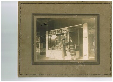
Photograph, Fresh fish and rabbits, c1930s
Many Ithacan Greeks who migrated to Australia prior to World War 2 worked with family members or friends in food vending industries such as fish shops, fruit shops and cafes. Many of these businesses were located in the Melbourne CBD or in the surrounding inner suburbs. A sepia photograph mounted on brown board of 2 men standing outside a fish shop in a strip shopping centre. The men are wearing aprons over their work clothes.south melbourne, peter drakopoulos. -
 Eltham District Historical Society Inc
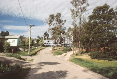
Slide, View looking northeast to turnabout near 10 McCarthy Grove, Montmorency, c.Oct. 1980
One of a series of images of roads and infrastructure taken by Eltham Shire Council Planning and Engineering officers. They provide perspective of the changes in housing styles and road development that began sweeping in from the mid 1970s with increasing urbanisation of what was once more outlying suburbs and regions.35 mm colour positive transparency Mount - Kodak Kodachrome CardProcessed Oct 1980houses, infrastructure, mccarthy grove, montmorency, roads -
 Eltham District Historical Society Inc
Slide, McCarthy Grove, Montmorency, extended driveway from Main Road, c.Oct. 1980
One of a series of images of roads and infrastructure taken by Eltham Shire Council Planning and Engineering officers. They provide perspective of the changes in housing styles and road development that began sweeping in from the mid 1970s with increasing urbanisation of what was once more outlying suburbs and regions.35 mm colour positive transparency Mount - Kodak Kodachrome CardProcessed Oct 1980houses, infrastructure, mccarthy grove, montmorency, roads -
 Eltham District Historical Society Inc
Slide, View looking southwest to turnabout near 9 McCarthy Grove, Montmorency, c.Oct. 1980
One of a series of images of roads and infrastructure taken by Eltham Shire Council Planning and Engineering officers. They provide perspective of the changes in housing styles and road development that began sweeping in from the mid 1970s with increasing urbanisation of what was once more outlying suburbs and regions.35 mm colour positive transparency Mount - Kodak Kodachrome CardProcessed Oct 1980houses, infrastructure, mccarthy grove, montmorency, roads -
 Eltham District Historical Society Inc
Slide, McCarthy Grove, Montmorency looking west near No. 27, c.Oct. 1980
One of a series of images of roads and infrastructure taken by Eltham Shire Council Planning and Engineering officers. They provide perspective of the changes in housing styles and road development that began sweeping in from the mid 1970s with increasing urbanisation of what was once more outlying suburbs and regions.35 mm colour positive transparency Mount - Kodak Kodachrome CardProcessed Oct 1980houses, infrastructure, mccarthy grove, montmorency, roads -
 Eltham District Historical Society Inc
Slide, McCarthy Grove, Montmorency looking east towards Reichelt Avenue, near no. 27, c.Oct. 1980
One of a series of images of roads and infrastructure taken by Eltham Shire Council Planning and Engineering officers. They provide perspective of the changes in housing styles and road development that began sweeping in from the mid 1970s with increasing urbanisation of what was once more outlying suburbs and regions.35 mm colour positive transparency Mount - Kodak Kodachrome CardProcessed Oct 1980houses, infrastructure, mccarthy grove, montmorency, roads -
 Eltham District Historical Society Inc
Slide, Quinn Estate, McCarthy Grove ext. driveway, Montmorency, near no. 31, c.Oct. 1980
One of a series of images of roads and infrastructure taken by Eltham Shire Council Planning and Engineering officers. They provide perspective of the changes in housing styles and road development that began sweeping in from the mid 1970s with increasing urbanisation of what was once more outlying suburbs and regions.35 mm colour positive transparency Mount - Kodak Kodachrome CardProcessed Oct 1980houses, infrastructure, mccarthy grove, montmorency, roads -
 Eltham District Historical Society Inc
Slide, Looking towards 99 Buena Vista Drive, Montmorency, c.Oct. 1980
One of a series of images of roads and infrastructure taken by Eltham Shire Council Planning and Engineering officers. They provide perspective of the changes in housing styles and road development that began sweeping in from the mid 1970s with increasing urbanisation of what was once more outlying suburbs and regions.35 mm colour positive transparency Mount - Kodak Kodachrome CardProcessed Oct 1980houses, infrastructure, mccarthy grove, montmorency, roads -
 Whitehorse Historical Society Inc.
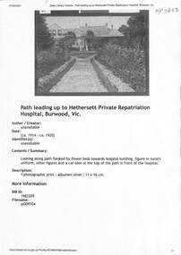
Document - Various including photos, newspaper items, Hethersett Private Repatriation Hospital, Burwood, 1866 - 1943
Between 1915 - 1917 Dr Ramsay Mailer and members of his family ran the 30 bed Hethersett Voluntary Military Hospital in Burwood for5 returned shell shocked and fatigued soldiers at his own expense. This property became part of the Presbyterian Ladies College in1939.A4 Print outs from blogspot, Trove (SLV), and newspaper obituariesnon-fictionBetween 1915 - 1917 Dr Ramsay Mailer and members of his family ran the 30 bed Hethersett Voluntary Military Hospital in Burwood for5 returned shell shocked and fatigued soldiers at his own expense. This property became part of the Presbyterian Ladies College in1939. mailer ramsay dr, world war 1914-1918, housing reform 1920s, camp mailer, hospitals, repatriation care -
 Whitehorse Historical Society Inc.
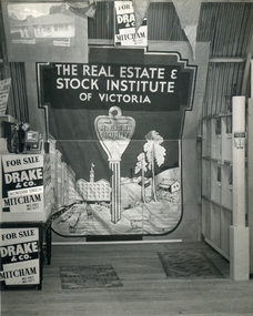
Photograph, Drake & Co Mitcham
During the period when the Armstrong family owned Drake & Co, Norman Armstrong became State President of the Real Estate and Stock Institute and son Raleigh, and later grandson Ian Armstrong were Presidents of the Eastern Suburbs Branch of the Institute and members of the State Council.Black & white photo of interior of Drake and Co, Real Estate Agents offices in Mitcham showing a Real Estate and Stock Institute of Victoria banners in full.;drake & co, real estate agents -
 Australian Multicultural Community Services
meeting minutes
Australian Polish Community Services was established in 1983 as a community, non for profit and charitable organisation, with the main purpose of responding to the needs and aspirations and promoting the interests of the Polish Australian community in western suburbs of Melbourne. The first Committee of Management meeting was held on 10/05/1983 first official document in history of Australian Polish Community Services2 sheets of paper from exercise bookhandwritten documentminutes, australian polish community services, polish community -
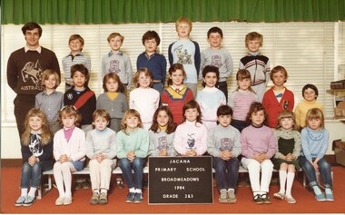 Broadmeadows Historical Society & Museum
Photograph - School Photograph, Jacana Primary School, Jacana Primary School, Broadmeadows, 1984, Grade 2 & 3, 1984
This 1984 photo shows Grades 2 and 3 at Jacana Primary School, once located in Melbourne’s northern suburbs. The school, now closed and demolished, served the local community for decades. This image offers a nostalgic glimpse into a bygone era of local education and childhood in Jacana.This 1984 photograph of Grades 2 and 3 at Jacana Primary School captures a moment in the educational and social history of Melbourne’s northern suburbs. As the school no longer exists, the image holds historical value, preserving the memory of a once-vital community institution and its students.Colour photograph on matte paper.White Label: PH-4471 Blue Label: PH-5189 Brown Label: See attached Sheet 1jacana primary school, education, class photograph, 1984, d. stanton, s. phillips, h. nagten, a. gough, c. hennessy, r. perceval, t. gray, l. ziervogel, s. gibbon, l. bailey, t. narman, b. wehbe, l. manson, d. scarffe, m. tiernan, m. miller, a. andre-janz, t. blythe, t. ponicwaz, i. szuhai, h. alderman, k. muscat, j. cilia, n. urlich, s. paniewaz, grade 2 & 3 -
Broadmeadows Historical Society & Museum
Photograph - School Photograph, Classic Studios Victoria, Grade 5/6P Jacana Primary School 1990, 1990
This 1990 photo shows Grades 5 & 6 at Jacana Primary School, once located in Melbourne’s northern suburbs. The school, now closed and demolished, served the local community for decades. This image offers a nostalgic glimpse into a bygone era of local education and childhood in Jacana.This school photograph of Grades 5 and 6 at Jacana Primary School in 1990 holds enduring historical and emotional value as a visual record of education in a now closed institution. It captures a moment in time that reflects the community spirit, diversity, and educational environment of Jacana during its operational years. As the school has since closed, the image serves as a poignant reminder of the role Jacana Primary played in shaping young lives and fostering local identity. It is a valuable artifact for former students, staff and the broader community, preserving the legacy of a place that once stood as a cornerstone of learning and connection. The image is also a record of the fashion and hairstyles of the era. Colour photograph with blue border on the bottom, on matte paper.jacana primary school, education, class photograph, grade 5/6p, 1990, mark layton, daniel blaney, gunduz tabag, bernadine cilia, joanne verzantvoort, walid hamid, peita anderson, salwa arabi, anthony schewtschuk, matthew maidorn, robert gusak, kasia goray, bronwyn robinson, michael hennessy, andrew martins, carrie lewis, kyle so, andrew jenkins, sandra connell, aaron manson, leo athanasiou, shar-rena fitzgerald, mr brian o'dea, debbie stewart, kelly coates, mr glenn payne, miss karen ringham -
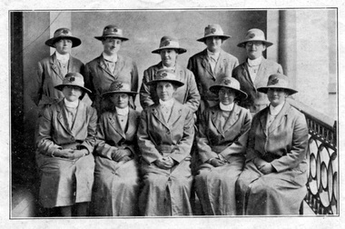 Royal District Nursing Service (now known as Bolton Clarke)
Photograph - Digital image, c.1922
The photograph appeared in the MDNS Annual Report of 1922 and is taken on the veranda of the Melbourne District Nursing Society (MDNS) Nurses Home at 39 Victoria Parade, Collingwood. The Sisters lived and worked out of the Nurses Home from June 1914 to 1953. They attended the disadvantaged in the inner suburbs of Melbourne. The Sisters and Matron are wearing the grey uniform and hat with a red Maltese cross is in the centre of the hatband which was introduced in 1921. These Sisters, plus two others visited 29.079 visits in the metropolitan area and in suburbs as far distant as Elwood, Glen Huntly, Deepdene, Essendon and Fairfield. Of the 1666 patients on the books 394 were midwifery patients nursed in their own homes. It is believed the Matron in the photograph is Matron Reynolds. In February 1885 it was recognized that nursing care was needed for the sick poor in inner Melbourne. The Melbourne District Nursing Society (MDNS) was founded on the 17th of February with one Trained nurse (Nurse) who qualified under the Hospital training system, commencing on the 1st of May, and a second employed six months later, both working in the now CBD, ie from Spencer Street to Spring Street and from Victoria Parade to Flinders Street. From its inception the Society was at the forefront of health care. They provided high quality nursing care; educated their patients in the curing and prevention of disease; teaching the importance of cleanliness and good nutrition, both by verbal instruction and demonstration, even supplying soup and milk when needed. At that time they walked the streets and lane ways amid the slums of inner Melbourne carrying their nursing bag containing lotion, ointments, powders, liniment, bandages, dressings, a case of spirits, and the Nurse's own clean apron. The also supplied equipment, such as earthenware hot water bottles, splints, urinals, bed pans, bed cradles, feeding mugs, and air-cushions as well as providing clean bed linen and nightdresses and clothes as necessary. In 1891 the first Nurses Home was rented for 1 year at £65 per annum at 66 Cardigan Street, Carlton; Nurses wages were now £60 per annum. A Doctor gave lectures from the Home to the public on the understanding and prevention of diseases. The Society decided to commence a Midwifery Service and Nurse Fowler, who had previously worked for the Society, was re-employed as their first trained Midwife. She began home births in August 1893 giving them Ante Natal care, taking midwifery bundles and providing clothes for the babe as needed. Following birth, she gave Post-natal care to the mother and babe twice a day for three days and then daily for a week, and longer if required. She resigned after twelve months and Nurse Wilkie was appointed to the position. As well as walking, the Nurses used Public transport in the limited areas it ran, though a taxi was used by the Nurses and Midwife in emergencies and at night. Late in 1891 the Society moved to larger rented premises at 49 Drummond Street and in 1902 moved to 188 Leicester Street, Carlton. The Nurses were becoming exhausted, particularly in the heat of summer. Permission to use bicycles was given to them in 1898 and the Society decided to purchase their own in 1903. A business man offered ‘new free wheel’ bicycles at £13 each, which included maintenance for one year. Bells and wooden frames were added at a cost of £5 per frame so the Nurses could carry extra equipment. Nurses bags were strapped to the handlebars. Soup was made for those in need 2-3 times a week, and if patients could not arrange to have it collected, the soup was delivered by the Nurses on their bicycles. Their use caused a change in uniform, with white pith helmets, and veils covering them and tied under their chins, now being used. In 1904 the Society relocated to rented premises at 5 Royal Terrace, Nicholson Street in Fitzroy. In 1913 a Nurse had her ‘board and residence, uniforms, bicycles and laundry expenses’ provided and was paid £50 a year for her first six months. At the end of a year her salary was increased by £5, and later she earned £60 a year. Over the years the Nurses complained their veils became wet in the rain and asked for a change of uniform, but this did not occur until 1921. In 1914 the Society was at last able to purchase their own premises, 'Floraston' 39 Victoria Parade in Collingwood. During the Spanish Influenza epidemic, in 1919, MDNS appealed for assistance to procure Motor vehicles so the Nurses could visit an influx of cases. Through trusts, grants and donations four 'Ford 'T Model' cars were procured which enabled the Nurses to triple their visits. It was recorded on the 21st of May, that the seven Nurses had visited 1,212 persons with influenza in the last three months, how many visits to each is not known. In the whole of 1918 the Nurses, including midwifery cases, visited 1,100 persons. It was also recorded on May 7th the Nurses were delivering 100 quarts of soup to the needy each morning. In winter they also carried wood in the cars to distribute to their destitute patients as needed. In 1921-22 many of the people nursed by the Trained nurses (Sisters) suffered from malignant and tubercular disease, often the Sister would visit to find the patient was desperately ill living in a room alone and no one there to even give them a drink. In these cases the Sister would send them to hospital, but if possible most cases were nursed in their home. During July 1921- 30 June 1922 the four Midwifery trained Sisters averaged 8 confinement cases a week and sometimes gave Post Natal care to 15 to 18 patients a day. At the time of confinement a Student from the Women's Hospital accompanied the MDNS Sister and if complications occurred the patient was transferred to the Women's Hospital. The Society often had to provide blankets, sheets, set of baby clothes and night gowns for the mother. In many instances the Society provided milk for many months. The midwifery Sisters often travelled long distances in the cars Through constant use the cars were in such a poor state they were sold in 1927 and the Sisters went back to using public transport, as well as their bicycles which continued to be used in inner areas until 1945.. The Midwives used taxis when a birth was imminent. Black and white photograph showing 9 Sisters, 5 standing at rear and Matron, in the centre, of 4 seated Sisters on a balcony wearing their Melbourne District Nursing Society (MDNS) uniforms of grey coats, with revered collars and belt, over their partly seen grey uniforms with white collars. Five of the Sisters are wearing glasses. All are wearing grey brimmed hats with a Maltese cross in the centre of the lighter colour hatband. Part of deep metal scroll work of the veranda rail can be seen. A concrete wall is behind the Sisters.mdns, mdns matron, miss reynolds, royal district nursing service, rdns, melbourne district nursing society, mdns uniforms -
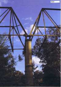 Greensborough Historical Society
Photograph, Maroondah aqueduct pipe bridge 2011, 2011_
in 1891 the Watts River (near Healesville) was tapped. It supplied water to Melbourne, via the Maroondah aqueduct. The Maroondah Reservoir, northeast of Melbourne, was completed in 1927 and water was piped via the Maroondah aqueduct to the northern suburbs. It was replaced by large pipes in the 1980s. Parts of the aqueduct structure remain.Copy of colour photographaqueduct pipe bridge greensborough, maroondah aqueduct -
 Puffing Billy Railway
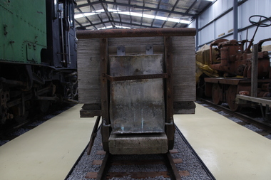
Wagon, Explosives, 1900s
18½-inch (460mm) gauge wagon came from the Commonwealth Explosives factory at Maribyrnong in Melbourne’s western suburbs. It has gun-metal wheels, as avoiding sparks was understandably a priority in an explosives factory. It also has water tanks to drip water on the wheels as an added precaution Historic - Industrial Narrow Gauge Railway - Commonwealth Explosives factory, Maribyrnong, Victoria, AustraliaExplosives Wagon - Four wheel wagon with timber frame, copper water tanks and bronze wheels.explosives wagon, puffing billy, commonwealth explosives factory, maribyrnong explosives factory -
Broadmeadows Historical Society & Museum
Photograph - School Photograph, Classic Studios Victoria, Jacana Primary School Prep/1/2 - 2003, 2003
This 2003 photo shows Grades prep, 1 and 2 at Jacana Primary School, once located in Melbourne’s northern suburbs. The school, now closed and demolished, served the local community for decades. This image offers a nostalgic glimpse into a bygone era of local education and childhood in Jacana.This 2003 photograph of Grades prep, 1 and 2 at Jacana Primary School captures a moment in the educational and social history of Melbourne’s northern suburbs. As the school no longer exists, the image holds historical value, preserving the memory of a once-vital community institution and its students.Colour photograph on matte paper, with names of people in their photograph.jacana primary school, education, prep/1/2, 2003 school photograph, amy matthews, sam accaputo, hana matar, jenny du, milan hurley-edwards, vincent tuua, nhi phan, filiz akyildiz, mrs. vivien mcnish, makarita solofa, orhan bozbay, jacqualine o'toole, ms carol taylor -
 Broadmeadows Historical Society & Museum
Photograph - Two Adults in the Park, 1990
This photograph was taken during the 1990 Jacana Primary School Christmas picnic, believed to be held at Greenvale Reservoir, a popular recreational area in Melbourne’s northern suburbs. The image features two adults—most likely members of the teaching staff—posing together in a relaxed and festive setting. This photograph, taken during the 1990 Jacana Primary School Christmas picnic believed to be held at Greenvale Reservoir, depicts two adults—most likely members of the teaching staff—posing for a casual portrait amidst the festive outdoor gathering. The image offers valuable insight into the social and professional culture of the school during this period. Jacana Primary School, established in 1959 in Melbourne’s northern suburbs, was a community-focused institution that emphasised both academic development and social cohesion. The annual Christmas picnic was a key event in the school calendar, providing an opportunity for students, staff, and families to celebrate the end of the school year in a relaxed, natural setting. The presence of staff members in the photograph highlights the important role teachers played not only as educators but also as community leaders and role models. Their participation in such events reflects the school’s commitment to fostering strong relationships between staff and students. Photograph on glossy paper of two adults in the park.PH18289 (crossed out) PH-4209 (crossed out) PH-4868jacana primary school, christmas party, 1990, jacana -
City of Kingston
Photograph - Black and white, 5 January 1984
Moorabbin, Cheltenham and Highett are suburbs in the City of Kingston with a diverse mix of development and zoning. The market gardens, farms and paddocks have gradually been sub-divided into housing and industrial estates and associated infrastructure such as schools and shopping facilities. The area includes many parks, reserves and golf courses.This aerial image covers a diverse section of the City of Kingston, taking in the suburbs of Cheltenham, Moorabbin, Beaumaris and Highett. By 1984, the market gardens of the district have been replaced by housing and factories. The Gas and Fuel state-of-the-art Scientific Services Department is visible on Nepean Highway Highett. The CSIRO Highett site can also be seen. Both sites have now been demolished and have undergone remediation. The Southland site is visible and yet to be redeveloped by Westfield. This image portrays the diversity of development in the City of Kingston with a mixture of green spaces, housing and commercial and industrial features.Aerial photograph of Cheltenham, Beaumaris, Moorabbin and Highett within the City of Kingston. The area depicted in the 1984 aerial view includes Eden Street and Edward Street, Cheltenham (top left), Weatherall Road and Reserve Road, Cheltenham/Beaumaris (top right), Turner Road and Chesterville Road, Moorabbin (bottom left), Nepean Highway (left section), Graham Road and Middleton Street, Highett (bottom right). A large section of this image includes Cheltenham Park and Victoria Golf Club.White text: 3831-219 Lens information [indecipherable] RINGWOOD M/S 7922-3 RUN 15 Clockface image 5,300' ASL VIC DLS© 5-1-84cheltenham, highett, industrialisation, urbanisation, moorabbin, beaumaris -
 Bayside Gallery - Bayside City Council Art & Heritage Collection
Photograph, Department of Crown Lands and Survey, Victoria, Melbourne Project: Brighton, Hampton, Sandringham, 1976
The Department of Crown Lands and Survey (1857-1983) was responsible for the administration of survey and mapping and the sale, occupation and management of crown land throughout its existence. This aerial photograph shows parts of Brighton, Hampton and Sandringham and was taken on 1 December 1976brighton, department of crown lands and survey, aerial photograph, bayside, port phillip bay, map, cartographic material, hampton, sandringham, green point, sandringham yacht club, south road, beach road, hampton street, melbourne project 1976 -
 Bayside Gallery - Bayside City Council Art & Heritage Collection
Photograph, Department of Crown Lands and Survey, Victoria, Melbourne Project: Brighton and Hampton, 1976
The Department of Crown Lands and Survey (1857-1983) was responsible for the administration of survey and mapping and the sale, occupation and management of crown land throughout its existence. This aerial photograph shows parts of Brighton and Hampton and was taken on 1 December 1976. brighton, department of crown lands and survey, aerial photograph, bayside, port phillip bay, map, cartographic material, melbourne project 1976, brighton yacht club, middle brighton baths, hampton, green point, brighton beach, south road, the esplanade, hampton street -
 Kew Historical Society Inc
Plan - Subdivision Plan, Golf View Estate, c.1922
Pru Sanderson, in her groundbreaking ‘City of Kew Urban Conservation Study : Volume 2 - Development History’ (1988), summarised the periods of urban development and subdivisions of land in Kew. The periods that she identified included 1845-1880, 1880-1893, 1893-1921, 1921-1933, 1933-1943, and Post-War Development. These periods were selected as they represented periods of rapid growth or decline in urban development. An obvious starting point for Sanderson’s groupings involved population growth and the associated economic cycles. These cycles also highlighted urban expansion onto land that was predominantly rural, although in other cases it represented the decline and breakup of large estates. A number of the plans in the Kew Historical Society’s collection can also be found in other collections, such as those of the State Library of Victoria and the Boroondara Library Service. A number are however unique to the collection.The Kew Historical Society collection includes almost 100 subdivision plans pertaining to suburbs of the City of Melbourne. Most of these are of Kew, Kew East or Studley Park, although a smaller number are plans of Camberwell, Deepdene, Balwyn and Hawthorn. It is believed that the majority of the plans were gifted to the Society by persons connected with the real estate firm - J. R. Mathers and McMillan, 136 Cotham Road, Kew. The Plans in the collection are rarely in pristine form, being working plans on which the agent would write notes and record lots sold and the prices of these. The subdivision plans are historically significant examples of the growth of urban Melbourne from the beginning of the 20th Century up until the 1980s. A number of the plans are double-sided and often include a photograph on the reverse. A number of the latter are by noted photographers such as J.E. Barnes.The subdivision advertised as the Golf View Estate in Camberwell included 32 allotments bordering on Glen Iris Road, Smith Street (now Smith Road), St Andries Street and Camberwell Road. In the post-war period in which the subdivision took place, the significance of Camberwell as the ‘Heathiest of Suburbs’ because of the undulating nature of its terrain and its high altitude was promoted. The sales pitch aimed at attracting and selling to ‘Gentlemen’ who could take advantage of the nearby trams, which would take them to the ‘heart of the city’.subdivision plans - camberwell, golf view estate -
Melbourne Tram Museum
Newspaper, The Age, “Fears Caulfield to Rowville tram plan no longer on track”, 30/05/2019 12:00:00 AM
Newspaper clippings titled: “Fears Caulfield to Rowville tram plan no longer on track” Newspaper clipping from the Age 30/5/2019 by Timna Jacks Councils in Melbourne's south-east suburbs concerned that plans for new tram line linking Caulfield train station and Monash University's Clayton campus have been shelved due to no money allocated in the budget. Premier Daniel Andrews had promised the government would plan and design an 18 kilometre tram route from Caulfield to Rowville.trams, tramways, planning, caulfield, tram routes, new tramway -
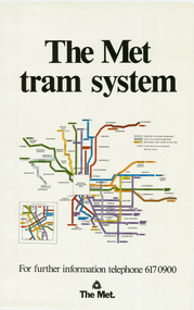 Melbourne Tram Museum
Poster, The Met, "The Met Tram System", mid 1990's
Poster - full colour on semi gloss paper titled "The Met Tram System" showing in a diagrammatic form the Melbourne tram routes, major street names, route numbers, principal suburbs, terminal names, central area (pre Docklands, post light rail to St Kilda and Port Melbourne) and ticket zones. Has The Met logo and the Public Transport Corporation names on the bottom. Mid 1990's, Batman Ave still shown. 2nd copy added 2-2-2019 and scanned, replaced image file.trams, tramways, melbourne, tramways, tram routes, map, posters -
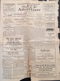 Kew Historical Society Inc
Newspaper, W D Vaughan Pty Ltd, The Kew Advertiser, Thursday November 25, 1926, 25/11/1926
"The Kew Advertiser , published by WD Vaughan, commenced publication in January 1926 and, before the year's end, a modern printing plant had been established at 128 Denmark Street (demolished). This later became the nerve centre for publication of four other local newspapers: The Hawthorn Standard (1932), the Eastern Suburbs Advertiser (1934), the Coburg Courier (1935) and the Brunswick Sentinel (1936). The last two were later sold to another publisher, and the remaining three merged in 1959 to form the Eastern Suburbs Standard. This, in turn, continued under that name until 1974, when it merged with a counterpart from Doncaster, the Whitehorse Standard, and then carried on (under various names) until 1980." (Source: City of Boroondara : Thematic Environmental History, p. 75)This work forms part of the collection assembled by the historian Dorothy Rogers, that was donated to the Kew Historical Society by her son John Rogers in 2015. The manuscripts, photographs, maps, and documents were sourced by her from both family and local collections or produced as references for her print publications. Many were directly used by Rogers in writing ‘Lovely Old Homes of Kew’ (1961) and 'A History of Kew' (1973), or the numerous articles on local history that she produced for suburban newspapers. Most of the photographs in the collection include detailed annotations in her hand. The Rogers Collection provides a comprehensive insight into the working habits of a historian in the 1960s and 1970s. Together it forms the largest privately-donated collection within the archives of the Kew Historical Society.The Kew Advertiser, Thursday November 25, 1926. An original copy of the Kew Advertiser dating from 1926 the kew advertiser, wd vaughan -- publisher, newspapers -- kew (vic.) -
 Sunbury Family History and Heritage Society Inc.
Photograph, 25th July 1986
Heavy snow fell across Melbourne and surrounding suburbs, including Sunbury, on 25th July 1985. The photograph taken from the pedestrian bridge at Sunbury Railway Station is looking north to the historic Macedon Street bridge. The widespread snow across the metropolitan area on that day caused much chaos.A coloured photograph of widespread snow across a railway line and the surrounding area.sunbury railway station, extreme weather events, snow storms -
City of Kingston
Photograph - Black and white, 17 January 1951
Moorabbin, Cheltenham and Highett are suburbs in the City of Kingston with a diverse mix of development and zoning. This 1954 image shows the market gardens, farms and paddocks of the Moorabbin and Cheltenham area. which have gradually been sub-divided into The Highett Gas Works is visible and Cheltenham Park and Victoria Golf Club.The suburbs of Cheltenham and Moorabbin were originally developed with extensive market gardens. Over time the district has been transformed with the farms and paddocks replaced by housing, factories and shopping centres. The Highett Gas Works on the Nepean Highway was a significant feature of the landscape and has now been demolished. and the site has undergone remediation.Aerial photograph of Cheltenham, Moorabbin and Highett within the City of Kingston. The area depicted in this 1951 aerial view includes Wickham Road, Highett (bottom right), Keys Road, Moorabbin (bottom left), Centre Dandenong Road Cheltenham (top left), Park Road, Cheltenham (top right), Nepean Highway (left section), Graham Road and Middleton Street, Highett (bottom right). Cheltenham Park and Victoria Golf Club are visible. Nepean Highway and the Frankston railway line run centrally through the image.White type: 1416-37 538 RUN239 LENS 5312" MELBOURNE METROPOLITAN 12150 17-1-51 ↆ M539 Black pencil: N [arrow]cheltenham, highett, highett gas works, market gardens