Showing 594 items matching " underground"
-
 Glen Eira Historical Society
Map - Victorian Railways
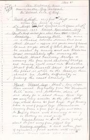
This file contains three items. 1. Original railways grid map of Victoria with passenger mileages (in miles) which shows railway stations in Glen Eira as part of the rail network. 2. Original pamphlet titled ‘Pocket History Vicrail 1839 – 1981’, dated 1981. Chronological history of milestones and dates, ie. 1981 Caulfield loop opened 24/01/1981 as part of underground rail loop. Image on front cover shows 2 images (steam train and stainless steel train). 3. Original pamphlet by Ministry of Transport titled ‘Your neighbourhood Public Transport System’ outlining fare structure. Stylised map of Caulfield (Glen Eira) neighbourhood.carnegie, bentleigh, caulfield, elsternwick, glenhuntly, ormond, murrumbeena, railways, public transport, bus, train, tram, railway stations, ‘vicrail’, underground rail loop -
 Bendigo Historical Society Inc.
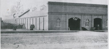
Photograph - BRICK BUILDING, 1861
black and white photo: brick bulding . Commercial ? Brick front with parapet , 2 arched doorways,3 arched windows, building frontrs street. 2 doors to underground cellar open. Windows barred, Side wall has brick buttresses. Galvanised iron roof with 6 glass skylights and louvred ventilator. Rear of Batchelder's cart to left. Male seated near cart. 3 males in timber pens rear of Batcherlders cart to left. Raised footpath. Protective stanchions at entrance door. On back in pencil ' not known' ' 13'Batchelderbuildings, commercial -
 Bendigo Historical Society Inc.
Document - NORTH JOHNSONS MINE - NOTES ON THE NORTH JOHNSONS MINE
One typed, one handwritten and one handwritten carbon copy of notes on the North Johnsons Mine on the Garden Gully Line of Reef. Notes include size of lease (which was very small, only 83 yards along the line of reef, and the late 1890's absorbed the Rose of Denmark lease, the next mine north, of 57 yeards along the line of reef, Depth of shaft, height of Sill, Locality, Plant, Early History, Prominence, Best Gold, Total Gold Yield and Dividends,Underground Connections and References. Albert Richardson Collection. document, gold, north johnsons mine, north johnsons mine, garden gully line of reef, rose of denmark, camerons reef, dagmar reef, johnsons no 1, johnsons no 2, special edition australian mining standard 1/6/1899, mines dept booklet bendigo goldfield geo brown 1936, mines dept quarterly and annual reports, annals of bendigo mining sections 1866 - 1917, a richardson, e j dunn's special report no 1 measurements taken from north johnsons mine transverse section 22/9/1892, wood & mcnair sharebrokers plan of leases of portion of bendigo goldfield to 4/5/1912 -
 Bendigo Historical Society Inc.
Map - HUSTLER'S REEF & HUSTLER'S REEF NO 1 MINES - PLAN OF THE HUSTLER'S REEF & HUSTLER'S REEF NO 1 MINES
Plan of the Hustler's Reef & Hustler's Reef No 1 Mines on the Hustler's Line of Reefs Bulletin No 33, Plate No XV. Plan shows the two mines with depth of levels, geological features and levels in relation to the shaft. Geological Survey of Victoria emblem and signed by H A Whitelaw, Underground Survey Office Bendigo, September 1913. Note - The Lease Boundaries shown on this plan are only in their approximate relative positions to Nos 13, Intermediate and 14 Levels of the Hustler's Reef No 1 workings, and Nos 15, 16 and 17 Levels of the Hustler's Reef workings.mining, parish map, hustler's reef & hustler's reef no 1 mines, geological survey of victoria, underground survey office bendigo, h a whitelaw, hustler's line of reefs -
 Bendigo Historical Society Inc.
Map - HUSTLER'S REEF NO 1 MINE - TRANSVERSE SECTION OF THE HUSTLER'S REEF NO 1 MINE
Map of a transverse Section of the Hustler's Reef No 1 Mine on the hustler's Line of Reefs Bulletin No 33, Plate No XXI. Map shows poppet legs at 801.07 feet above Sea Level and drawing of shaft with the different levels. Also shown are geological features and stone encountered. Geological Survey of Victoria emblem H Herman, Director, W Dickson, Secretary of Mines and The Hon. J. Drysdale Brown MLC Minister of Mines. Signed by H S Whitelaw, Underground Survey Office Bendigo, September 1913. This item has not been scanned or photographed.mining, parish map, hustler's reef no 1 mine, hustler's line of reefs, geological survey of victoria, underground survey office bendigo, h s whitelaw, h herman, w dickson, the hon j drysdale brown -
 Bendigo Historical Society Inc.
Map - HUSTLER'S ROYAL RESERVE NO 2 (PARK SHAFT.) - TRANSVERSE SECTION OF THE HUSTLER'S ROYAL RESERVE NO 2
Transverse section of the Hustler's Royal Reserve, No 2 (Park Shaft.) on the Hustler's Line of Reef. Bulletin No 33, Plate No IX. Section shows poppet legs and sill of shaft at 755.70 ft above sea level, depth of levels, type of stone encountered including lava and geological features. Geological Survey of Victoria emblem and beneath it H. Herman, Director, W. Dickson, Secretary of Mines and The Hon. J. Drysdale Brown MLC Minister of Mines and signed by H S Whitelaw, Underground Survey Office, Bendigo September 1913.mining, parish map, hustler's royal reserve no 2 (park shaft.), h s whitelaw, underground survey office bendigo, geological survey of victoria, h herman, w dickson, the hon j drysdale brown mlc, hustler's line of reef -
 Stawell Historical Society Inc
Photograph, Saw Mills at Childe’s Glenbower Creek in Halls Gap 1866
Saw Mills Halls Gap (Childe’s Glenbower Creek). Part of a collection of Photographs by Mr. O.G. Armstrong as commissioned by the Shire of Stawell for the Inter-colonial and Paris Exhibition in Melbourne in 1866. During the years of gold, the hardwood forests around Stawell were ravaged to provide timber for the mines. It was used undergrounds to shore up workings, and millions of feet of it were fed into furnaces and kilns in which the quartz was roasted. In the years after the gold boom, hardwood from the Grampians was milled for building timber. Wherever there are large tracts of natural bushland, fires are always a danger. A huge fire in January 1939 caused havoc in the Grampians, burning out towns and sawmills such as the one pictured. There have been no sawmills in the Grampian since that fire. stawell industry -
Bendigo Historical Society Inc.
Letter - KANGAROO FLAT GOLD MINE COLLECTION: WESTERN MINING CORPORATION TO J.O. REYNOLDS, 11th June 1980
Letter addressed to D. McClure, M.L.A., June 11th, 1980 from Western Mining Corporation Limted. Letter outlines the plan to 'use a commercial elevator rather than a winding system for placing tourists into the underground exhibition'. Western Mining Corporation intended to make a donation to fund this venture but 'the money involved is rather more than we had in mind'. The original quote was $45,000 but is going to be in the range of $200,000 to $300,000. A two page file note on a telephone conversation between Daryl McClure and J.O. Reynolds of WMC re the Central Deborah Gold Mine is appended to the letter.bendigo, gold mining, central deborah gold mine, bendigo, central deborah gold mine, gold mining, western mining corporation, daryl mcclure, j. reynolds, arvi parbo. -
 Bendigo Historical Society Inc.
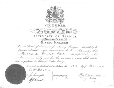
Document - RICHARD REED DOCUMENTS, 1914
Photocopies of documents relevant to Richard E Reed, Underground Manager, Great Extended Hustlers Mine. Circa 1914 1. Certificate of Service for Richard Reed 2. Two letter of reference 3. Two letters of commendation for Richard Reed for his actions during the Great Extended Hustlers Mine disaster. 4. Letter informing Richard reed that his bravery would be rewarded by giving him a government position. 5. Extract of Birth entry for Richard Reed. Born 23.12.1869 to Richard Reed and Emily Veale. 6. Copy of a wedding group. Undated with no names. Possibly Richard Reed? -
 Bendigo Historical Society Inc.
Document - ALBERT RICHARDSON COLLECTION: BIG DEBORAH GOLD MINE
15 page document, photocopied. A collection of mine managers' reports and Albert Richardson's research re the mine known as the 'Big Deborah' on the Deborah line of reef. Contains details of the engine house, the boilers, the winding engine, reconditioning the boilers, the poppet legs, shaft details and underground equipment. The poppet legs are steel and originally from the 'Windmill Hill' mine, Sebastian. The Big Deborah had a shaft depth of 2017 feet, the No. 2 shaft was 240 feet. Mine formed in 1932, ceased operations in 1959, located in Golden Square, near the railway line. Report on diamond drilling at North Deborah.bendigo, mining, big deborah gold mine -
 Melbourne Tram Museum
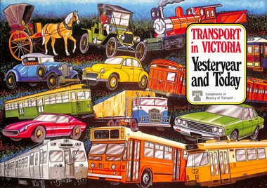
Book, Ministry of Transport, "Transport in Victoria - Yesteryear and Today", 1980
Pamphlet or Book - 20 pages, full colour printed on gloss paper, centre stapled titled "Transport in Victoria - Yesteryear and Today", published by the Ministry of Transport giving an outline of Victoria's transport history from 1834. Provides a short history of the state transport system, railways, roads, trams, Metropolitan planning, the Bland report, social changes, the underground loop, transport interchanges, West Gate Bridge, Roads and Freeways, transport inquiry of 1980 and environmental changes resulting from motor cars. 2nd copy added 14-5-2016 from the estate of Charles Craig.trams, tramways, minister for transport, railways, trb, crb, murla, planning, history -
 Melbourne Tram Museum
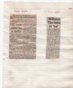
Newspaper, Herald Sun, "12 tram rides for a dollar", "Wilcox: The tube is on", 31/03/1969 12:00:00 AM
Newspaper Clipping - set of two adhered to a sheet of ruled quarto paper with punched holes on the left hand side. 1 - "12 tram rides for a dollar" - Herald newspaper 31/3/1969, written by Max Tomlinson about the introduction of the new "City Section Concession Card" on that day. Tells the story of a conductor, Mrs. Moore accidentally sold a book of 20 cards for $1 to a passenger. 2 - "Wilcox: The tube is on" - Herald newspaper 31/3/1969 - about a statement by the Minister for Transport on the HSV7-3DB TV programme "Meet the Press" - about the Melbourne underground loop.trams, tramways, tickets, railways, city section, melbourne -
Bendigo Historical Society Inc.
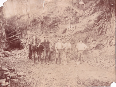
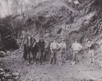
Photograph - Great Extended Hustlers Gold Mine Sandhurst, April, 2014
Seven men were killed at the Great Extended Hustler's mine disaster on 2nd May 1914 by an explosion of dynamite occurring as the men were waiting at the plat to ascend the mine at the end of their shift. No blame was attached to anyone in the findings of the inquisition. It was unknown what caused the dynamite to explode. This document formed part of the research done at the time by Bendigo Historical Society, of the 100 years commemoration of the mine disaster, held at Hustler's Hill in 2014. Two pages of photocopies of images from the 'Australasian Sketcher' May 17th. 1873, of the Great Extended Hustlers Gold Mine Sandhurst. First page: across top of image 'Quartz Mining - The Great Extended Hustlers Mine, Sandhurst'. Across bottom of image ' General View of the Principal Shafts'. Image shows mine buildings, trestle way, mine dam in foreground, poppet head in background. Mining chimneys in background. Second page: same view as above with five small images of mine operations below; men underground, men in mine cate, man pushing ore truck. great extended hustlers, goldmining, accident, 1873 -
 Bendigo Military Museum
Photograph - PHOTOGRAPHS WW1, C.1915
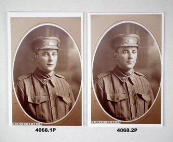
.1) & .2) Albert Edward LADD (Bendigo) No. 1071, enlisted in the AIF on 1.8.15 in Mining Corps Coy 3, aged 29 years and 6 months. Embarked for England 20.2.1916. KIA 27.1.1916 while serving with the 3rd Aust. Tunneling Coy. This was at "Black Watch Sap Hill 70". The Germans were laying underground mines at the same time as the Australians. The Germans blew their mines at 12.40am, this combined with the Australian ammonal mines made a massive explosion killing over 20 Australians. Crumps & Camouflets by Damien Finlayson describes this in his book on pages 151-153. .3) In the photo are from left, Julia Ann Ladd, Rita Mary Ladd, Florence May Ladd and Albert Edward Ladd. Prewar, Albert worked at the "Coleman & Tachees Mine" in California Gully..1) & .2) Photos, sepia tone, portrait of a soldier in peak hat wearing a tie, oval shape with surround. .3) Photo, sepia tone, women with two children and soldier, one child on a setting, one on soldiers knee..1) & .2) Inset on front: "12.07.11-18.04.15" .3) Inset in front: "12.07.11-18.04.56photographs, 3rd, hill 70, kia -
 Tatura Irrigation & Wartime Camps Museum
Folio, Garfield
GARFIELD ž Kilmartin Road, Cooma.|John Thomas Dougherty, an American, came to the Tatura area in 1874. He married Emily Whitnell from Whroo in 1883 and they had nine children.|He started building Garfield in 1886 and it was not completed until 1897. The building was named after President Garfield of America.|The building still contains the original Ericson wall telephone with its tag inside dated 1906. The house contains many features such as Jacobean over mantel and fire surround in the dining room, stained glass, a push button bell, and a stair well leading to an underground living area used in the summer for coolness. A new glass stair well was installed in the 1980®s to allow more light into the area. J.T. Dougherty died 1936.Photos and foolscap sized documents in a black A 4 size folder.documents, agreements -
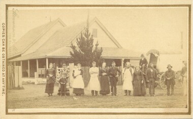 Bacchus Marsh & District Historical Society
Photograph, Cheese Factory Waddell Street Bacchus Marsh 1883
The Cheese Factory in this image was opened around 1879 by Mr. G.G. Pearce. It was in Waddell Street. It was one of the first cheese factories in Victoria. It was later owned and operated by William Telford with the assistance of John Mahon. The factory was described in the Bacchus Marsh Express newspaper as an important business and service for the region. G.G. Pearce was reported to have spent a good deal of money in setting up the factory to ensure it was one which produced high quality cheese using modern methods of production. The factory was sold in 1889 to a Mr. H. W. King who was from Abbotsford in Melbourne. Unfortunately within a few days of Mr King buying the factory it was completely destroyed in a fire. All that was left were two large pine trees and two large underground concrete tanks.G.G. Pearce was described as a pioneer of cheese factories in Victoria. His first factory was just outside of Bacchus Marsh at Hopetoun. Around 1879 he moved into Bacchus Marsh and opened a new purpose built factory in Waddell Street. The Bacchus Marsh Express newspaper reported that no expense had been spared in constructing this factory. The factory was completely destroyed in a fire in 1889 which makes it fortunate that this image was captured of this early cheese factory in Victoria.Small sepia unframed photograph on card with gold border framing photograph. Housed in the album, 'Photographs of Bacchus Marsh and District in 1883 by Stevenson and McNicoll'. The image shows a group of men and women standing in a row in front of the Bacchus Marsh Cheese factory. One of the women is holding a small child. In front of another woman stands a young boy. Behind them is a covered wagon with a man seated upon it. Some of the men and women are wearing long aprons. In the background is the Cheese Factory. It is a large wooden structure with a high and steep pitched roof.On the front: Stevenson & McNicoll. Photo. 108 Elizabeth St. Melbourne. COPIES CAN BE OBTAINED AT ANY TIME. On the back: LIGHT & TRUTH inscribed on a banner surmounted by a representation of the rising sun. Copies of this Portrait can be had at any time by sending the Name and Post Office Money Order or Stamps for the amount of order to STEVENSON & McNICOLL LATE BENSON & STEVENSON, Photographers. 108 Elizabeth Street, MELBOURNE stevenson and mcnicoll 1883 photographs of bacchus marsh and district, cheese factories, bacchus marsh cheese factory -
 Stawell Historical Society Inc
Photograph, Fountain Head Brewery at Armstrong 1866
Fountain Head Brewery Armstrong's. Part of a collection of Photographs by Mr. O.G. Armstrong as commissioned by the Shire of Stawell for the Inter-colonial and Paris Exhibition in Melbourne in 1866. The brewery, a three-storey high building, was established close to two streams which joined the Concongella Creek near Armstrong, although the water required to run the brewery was obtained from a natural underground spring which is still visible. Further findings of Gold in Victoria around 1859-1860 brought a large rush of miners to the area. Some stayed on to become merchants, farmers, etc. Jens Kofoed, a shipwright from the Netherlands, was one who came to the area at this time. He and his family move to Armstrong in 1860, establishing the Fountain Head Brewery, which employed quite a number of people for about 40 years. stawell industry -
 Federation University Historical Collection
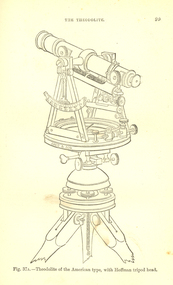
Book, Bennett H. Brough, A treatise on Mine-Surveying, 1904
The author, Bennett H. Brough was an associate of theRoyal School of Mines, a member of the COuncil of the Institution of Mining Engineers, a fellow of the geological society and of the Institute of Chemistry, a member of the Mining Institute of Cornwall, and a former instructor of mine-surveying at the Royal School of MinesRed had covered book 372 pages - part of Griffin's Mining Series. Contents include general explanatinos of surveying, an historical sketch, mineral deposits, mining terms, measures of length, measurement distances, the chain, rods, steel bands, measuring wheel, Miner's Dial, Magnetic needle, Fixed needle, German Dial, theodolite, traversing underground. Surface-surveys. plotting the survey, calculation of area, leveling, Telescope, Setting out, Mine-Surveying Problems, Mine Plans, Photographic Surveying, examination Surveying. Illustrations include: Whitelaw's Dial (Fig 22), Theodolite of the American Type with Hoffman tripod head, (fig 37a)mining, surveying, miner's dial, chain, survey, theodolite, scientific instruments -
 Bendigo Historical Society Inc.
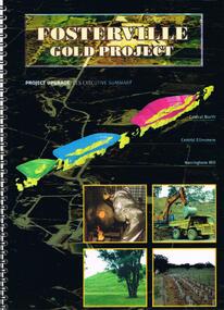
Document - FOSTERVILLE GOLD MINE COLLECTION: FOSTERVILLE GOLD PROJECT UPGRADE EXECUTIVE SUMMARUY
Black cover book, wire binding, 13 pages of text and maps. On front: Fosterville Gold Project' Map of ore body on cover - Central North, Central Ellesmere, Harringtons Hill. Contents include: open pits, heap leaching, waste dumps, estimated project life, changes from previously approved project, estimated project life, main project components, expanded open pits and underground mines, processing sulphide ore, tailings storages, waste rock dumps. Principles of rehabilitation, site preparation, rehabilitation activities during operation and decommissioning activities. Environmental issues, and summary of proposed new operating conditions.bendigo, mining, fosterville gold mine -
 Bendigo Historical Society Inc.
Document - LONG GULLY HISTORY GROUP COLLECTION: REASONS FOR PLACEMENT OF PLAQUES IN THE NEW CHUM PARK
Two reasons for placement of Plaques in The New Chum Park. One is to acknowledge the contribution that both the Cornish and German people who lived and worked in Long Gully made to the establishment of City of Greater Bendigo. The second, Famous Journalist Anthony Trollop visited Bendigo just as Underground Mining was starting to blossom. His remarks of Bendigo were uncomplimentary as that of Ballarat, which he complimented as a beautiful city. Twenty years later thanks to U/ground mining Bendigo rivalled Ballarat as a beautiful city to which the residents of Long Gully played a major role. Heading at top of page - Long Gully History Group.bendigo, history, long gully history group, the long gully history group - reasons for placement of plaques in the new chum park, long gully history group, city of greater bendigo, anthony trollop -
 Ballarat Tramway Museum
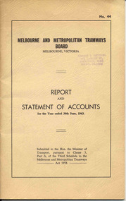
Document - Report, Melbourne and Metropolitan Tramways Board (MMTB), "Report and Statement of Accounts" for year ended 30 June 1963, 1963
Annual report of the MMTB for the year end 30/6/1963 - No. 44 - buff heavy paper cover with 52 pages on inside giving details of the MMTB Board, Officers, Balance Sheet, Statement of funds, operation, schedule of debenture, investments, Auditors reports, record of Annual traffic receipts, passengers, miles etc, tram and bus routes operated, statistical information, graphs and photographs. Photos include site preparation for new Doncaster depot, decorated tramcar for Melbourne cup carnival Nov. 1962, MMTB float - Melbourne Moomba festival Feb. 1963 and Demonstration model of Underground Tramway Intersection.4950 - has Graeme Breydon's address stamp on front cover.trams, tramways, mmtb, melbourne, annual reports, operations, trackwork -
 Bendigo Historical Society Inc.
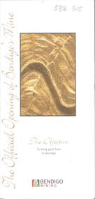
Card - Kangaroo Flat Gold Mine Collection: The Official Opening of Bendigo's Mine, Bendigo Mining NL, October 2006
Trifold invitation. On front cover is gold coloured image of rock strata. Written underneath: 'The Objective, to bring gold back to Bendigo'. On bottom of front page 'Bendigo Mining' with poppet head logo. Inside on first page: Your invitation- Peter McCarthy, Chairman Bendigo Mining Limited and Doug Buerger, Managing Director and Chief Executive Officer, request the pleasure of your company for the official opening of Bendigo's Mine at the kangaroo Flat site by Hon Steve Bracks, Premier of Victoria, on Friday 20 October, 2006. Colour photos of a gold pour, underground mining and a miner, on other pages of invitation. environment, kangaroo flat, goldmining, , environmental impact, exploration, mining, bendigo mining, doug buerger, peter mccarthy -
Bendigo Historical Society Inc.
Letter - Kangaroo Flat Gold Mine Collection: Mining Lease 1345
One page letter from Department of Industry, Technology and Resources to George H. White, Development Manager, Western Mining Corporation, Eaglehawk, re mining lease no. 1345, Bendigo Gold Project. Approval of a working proposal for evaluation at the Carshalton Shaft has been sought by Western Mining Corporation. The Department of Industry, Technology and Resources 'hereby approves the proposed underground exploration at South Carshalton Shaft including the dewatering activities outlined in your report dated July 1987'. The Minister for Planning, Jim Keenan, has exempted the exploration works from the Environment Effects Statement. Shire of Strathfieldsaye have issued a planning permit. western mining corporation, department of industry, technology and resources, dewatering, carshalton shaft, environment effects, shire of strathfieldsaye -
 Bendigo Historical Society Inc.
Photograph - Kangaroo Flat Gold Mine Collection: photo album 1998
Photo album, black cover, gold border. One hundred colour photos, some with annotations. Label on front of album: Portal, machinery, underground shots 1998; drilling in Deborah St.; mines rescue vehicle; various staff; E.E.S. Displays; Board Meeting 1998. Staff photos: Rob Charlton, pump at Red, White Blue Cons.; Andrew Breen Workshop Manager; John Cahill; Patrick O'Boyle Mine Rescue Vehicle; John Cahill; Ben Clayton; Ricky Hannah; April Westcott; Ivette Maggs site clerk McMahons; Wayne Woodward; Fiona Hunt; Steve Woodall.kangaroo flat gold mine, bendigo mining nl, new bendigo gold project, goldmining, personnel, doug buerger, colin burns, tarnagulla, new moon, displays, box cut, unity mining, aerial photos, 1998 -
 Bendigo Historical Society Inc.
Document - GREAT SOUTHERN MINE - NOTES ON THE GREAT SOUTHERN MINE
One copy of hand written and one copy of typed notes on the Great Southern Mine. Notes include Size of lease, Depth, Locality, Plant, Early History and Best Gold. Note on underground connection between the Great Southern 941 feet level to Ulster United 893 feet level. Reference: Mines Dept Special Edition Australian Mining Standard 1.6.1899, Mines Dept Booklet Bendigo Goldfield Geo Brown 1936, Mines Dept Quarterly and Annual Reports, Annals of Bendigo 1878 to 1915 Mining Sections, A Richardson, Catalogue Mining Sales J H Curnow 10.4.1947.mine, gold, great southern mine, garden gully line of reef, ulster united, a richardson -
 The Beechworth Burke Museum
Photograph
This photograph depicts a reef mine in Beechworth. Reef mining, or quartz reef mining, was common in 19th Century Victoria. This gold mining technique requires mine shafts to be sunk into underground quartz reefs, with horizontal tunnels dug from the original shaft at differing levels to find the gold-bearing rock. The quartz would then be hoisted to the surface, which would then be pounded to access the gold in its metallic state. Gold was discovered in Beechworth in February 1852, at Spring Creek. Within 11 months of that discovery, over 8000 hopeful prospectors quickly descended on this region, transforming it into a thriving, wealthy township. Reef mining and hydraulic sluicing were gold mining techniques used in this region in the 19th and early 20th centuries. This photograph interestingly contains dogs alongside the miners. While dogs have been recorded as deterrents to thieves in the Victorian goldfields, these dogs appear as companions to these men.The search for gold is ingrained into the history of Victoria and therefore, images like this one can reveal important information for society and technology for the date when the photograph was taken. It also shows a location where reef mining was undertaken which provides insight into the impact on the environment at a time when it was done. Although quartz is one of the most common minerals found in the earth's crust, it does not always contain gold. Those reefs that do are rare and highly sought after by prospectors. The Beechworth Burke Museum has additional images relating to gold mining which can be analysed and studied alongside images like this one.Sepia coloured rectangular photograph printed on gloss photographic paper. Obverse: Reverse: United Shire of Beechworth/ Shire Secretary/ Reef Mining, Beechworth./ 6167.abeechworth, burke museum, gold, gold mining, gold rush, victorian gold rush, reef mining, quartz, companion dog, horse and cart -
 The Beechworth Burke Museum
Photograph - Photograph - Reproduction
This reproduced photograph depicts a reef mine in Beechworth. Reef mining, or quartz reef mining, was common in 19th Century Victoria. This gold mining technique requires mine shafts to be sunk into underground quartz reefs, with horizontal tunnels dug from the original shaft at differing levels to find the gold-bearing rock. The quartz would then be hoisted to the surface, which would then be pounded to access the gold in its metallic state. Gold was discovered in Beechworth in February 1852, at Spring Creek. 8000 hopeful prospectors quickly descended on this region within the year, transforming it into a thriving, wealthy township. Reef mining and hydraulic sluicing were gold mining techniques used in this region in the 19th and early 20th centuries. This reproduction photograph interestingly contains dogs alongside the miners. While dogs have been recorded as deterrents to thieves in the Victorian goldfields, these dogs appear as companions to these men.The search for gold is ingrained into the history of Victoria and therefore, images like this one can reveal important information for society and technology for the date when the photograph was taken. It also shows a location where reef mining was undertaken which provides insight into the impact on the environment at a time when it was done. The Beechworth Burke Museum has additional images relating to gold mining which can be analysed and studied alongside images like this one.Black and white rectangular reproduction photograph on gloss photographic paper. Obverse: Reverse: L is miners 26%/ 10 x 8/ 6167.bbeechworth, burke museum, gold, gold mining, gold rush, victorian gold rush, reef mining, quartz, companion dog, horse and cart -
 Federation University Historical Collection
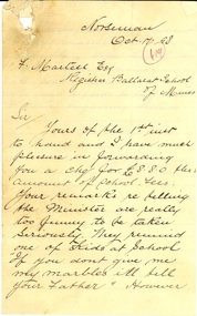
Letter, J.B. Rankine to Frederick Martell, 1898, 17/10/1898
"Mr. J. B. Rankine, the inspector for the Dundas goldfield, entered upon his duties on June 4, 1897. He states that his preliminary examination of the mines in active operation on the field, which was of a hurried nature, revealed in several instances a very unsystematic method of mining, which must have been attended with grave risk to the workmen had it been allowed to continue. The underground workings in one, particular mine which he inspected, and wherein a large number of men were employed, were of such a serious and dangerous nature that immediate steps and measures had to be taken to secure the ground for the safety of the men so employed. Without entering on this occasion into the question of culpability, he desired to place on record that the manager had shown a readiness and willingness to carry out his (the Inspector's) instructions. (West Australian, 21 February 1898)Handwritten letter on folded, lined paper. The letter was written in Norseman and relates to school fees for the Ballarat School of Mines. Norseman Oct 17 98 F.Mmaretll esq Registrar Ballarat School of Mines Sir Yours of the 1st instant to hand and I have much pleasure in forwarding you a cheque for L8.8.0 the account of school fees. Your remarks re telling the Minister are really too funny to be taken seriously. the remind one of kids at School "If you don't give me my marbles ill tell your father" however you have been very patient in the matter + I don;t grumble. Hope school is doing well + maintaining its good name, My kind regards to proff Smith + other enquiring friends Yours very truly J.B. Rankinej.b. rankine, dundas goldfield -
 Melbourne Tram Museum
Negative - cable trams - Collins and Elizabeth Sts, c1914
Photograph of cable cars in Elizabeth St at the corner with Collins St. Has the Elizabeth St station in the view, along with Craigs and the Royal Bank. Rod Atkins advised 24/08/2020: "Dates from around 1914. taken 11.53 am in high summer. The Flinders Street Railway station looks complete but we still have all the telephone cables on poles in both Elizabeth and Collins Streets. I don't know the year they all went underground. We have two standard "Fitzroy" trams in Collins Street and one West Melbourne tram with standard eight-window trailer - no bogie trailers in the photo. Some of the West Melbourne trailers were still six window cars in the 1920's. The major building in the photo is the "Royal Bank" on the South East Cnr. of Collins and Elizabeth Street. "Yields information about the intersection of Collins and Elizabeth St.Copy negative of an illustration and a black and white print.On rear of print in ink "T153, Melbourne Tramways Co, later MMTB. North Fitzroy cable in Collins St. West Melb & Brunswick in Elizabeth St, about 1920?. " W Jack photo" and in top right hand corner "28"trams, tramways, cable trams, collins st, elizabeth st -
 Warrnambool and District Historical Society Inc.
Documents, Rolf Crawley, Warrnambool, Warrnambool Race Course, 1920s and 30s
These documents deal with improvements in the 1920s and 30s (drainage, painting etc) to the Warrnambool Race Course. In 1854 the Warrnambool Racing Club was established and the first race meeting on the present day Warrnambool Race Course was held in 1858. These documents came from the office of Rolf Crawley, an engineer, architect and surveyor in private practice in Warrnambool and the engineer for the Shire of Warrnambool from 1935 to 1968. His grandfather, father and uncle were also engineers and worked in that capacity or as the Shire Secretary for the Shire of Warrnambool, with the Crawley family recording a total of 132 years of service to the Shire. The Shire of Warrnambool existed from 1863 to 1994. The documents came into the possession of Michael Hand who had taken over the private surveying business of Rolf Crawley in Warrnambool. The Warrnambool and District Historical Society acquired these documents and other Crawley material, from the Michael Hand estate. These documents are of considerable interest as they concern the Warrnambool Race Course improvements in the 1920s and 30s and come from the office of Rolf Crawley of Warrnambool. These are seven documents relating to the Warrnambool Race Course: .1 A manila folder with a handwritten title on the front cover and typed and printed material inside .2 A sketch map of the Warrnambool Race Course produced on heavy quality white paper. .3 Hand-drawn material on the underground drains on the Warrnambool Race Course produced on heavy quality white paper .4 & .5 Longitudinal section of the main drain, Warrnambool Race Course, produced on heavy quality white paper .6 Section of the drain near the fence and culvert of the Warrnambool Race Course produced on heavy quality paper .7 A piece of paper giving the chainage of the Warrnambool Race Course in red handwriting. warrnambool race course, rolf crawley, warrnambool