Showing 942 items matching "channels"
-
 Tatura Irrigation & Wartime Camps Museum
Photographs, Anderson collection of irrigation and farm photos, c.1920 (Loaned), c.1920
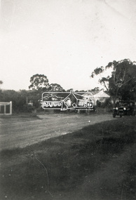
Collection of photos taken c.1920 by the Anderson family. Carlton and Bill Anderson left Murchison for a soldier settlement block at North West Mooroopna, 2 miles from the school. Bill had been a stretcher bearer in WW1. Photos taken by Anderson family of general farming activities, irrigation channel construction with horse teams, Goulburn Weir, Waranga Basin western outlet structure and channel, official opening ceremony. Photos loaned for copying.|1. Outlet structure, possibly the opening.|2.Western Channel.|3.Waranga Basin inlet.|4. Waranga Basin outlet.|5,6.Goulburn Weir.|7,8 Channel construction with horse teams.|9.Skid scoop.|10. Group at Bain.|11."Spot", Bill Anderson and the team.|12.Teams take time off.|13.Washing up.|14.Spring cart and "Smoko"|15.Bill Anderson holding horse.|16.Team of four.|17.A good crop.|18.Wonkey scoop with two horse team.|19,Horses at rest.|20.Head in nose bag.|21.Bill Anderson & Marty Clooney, tents, wagons and gig.|22.Wally Wybrow grooming horse.|23 Bill Anderson, Marty Clooney and furphy tank.|24. Four horse teams.|25.Carlton Anderson? cutting hair.|26,27.|28.Three wheel trolley made from old harvester.|29. Harvester.|30.Wally.|31.Marty Clooney and horse.|32|33.Seven horse team.|34-43.Various farm photos -
 Warrnambool and District Historical Society Inc.
Financial record - Journal Town of Warrnambool 1906-1914, Circa 1906
This journal contains entries which relate to the expenses of the administration of the town in the early 20th Century. It contains entries which relate to items such as public works, kerbing and channelling, library and museum, abattoir fees, pure food act, limestone and bluestone road metal and salaries.The entries in this journal provide an overview of expenses and administration costs in early 20th century. There is much information contained in the costs which states when works were completed.Green cloth covered card journal with light brown leather spine and corners. Scrolled brown pattern down edges of spine cover. Edges of pages coloured in green, pink and yellow. Inside front and back covers is coloured light and dark blue. 103 pages. Maroon label on front cover with gold lettering and border. It contains three loose sheets of paper. One dated November 1912 written by H E Lawson calling on subscriptions to support a group to lobby for country interests. A second sheet refers to a poll for a new High School for Warrnambool. The other two sheets refer to voting rights. Journal Town of Warrnambool on front cover. Arnall and Jackson engravers and lithographers, Printers and manufacturing stationers 478 Collins St Melbourne No 96927 9/6/06.town of warrnambool1906-1914, warrnambool history, warrnambool town expenses 1910 -
 Eltham District Historical Society Inc
Photograph, Looking towards the Railway Station, Were Street, Montmorency, c.1940, 1940c
Other photos of Were St featuring the Dandy family dated 8 October 1950 show an unsealed road with concrete kerb and channeling. The surrounds look very similar but no concrete kerb and trees in footpath significantly younger and smaller in size; hence c.1940Roll of 35mm black and white negative film, sectioned into frames; copy of print photograph Ilford FP-4montmorency, railway station, were street -
 Eltham District Historical Society Inc
Photograph, Looking south on Were Street towards Rattray Road, Montmorency, c.1940, 1940c
Other photos of Were St featuring the Dandy family dated 8 October 1950 show an unsealed road with concrete kerb and channeling. The surrounds look very similar but no concrete kerb and trees in footpath significantly younger and smaller in size; hence c.1940Roll of 35mm black and white negative film, sectioned into frames; copy of print photograph Ilford FP-4montmorency, railway station, were street -
Tatura Irrigation & Wartime Camps Museum
DVD, John Burgan, Friendly Enemy Alien, 2006
Filmed by John Burgan, an English documentary maker for Berlin TV History Channel. Filmed in Sydney, Melbourne, Narua, Dunera Jewish refugee internees and Afghan illegal boat people. Discussing circumstances and treatment of coming Enemy Aliens coming to Australia in 1940 and 2001.Clear plastic large DVD case. DVD is sky blue with silver pattern and textjohn burgan, berlin tv history channel, jewish refugees, afghan illegal boat people, documentaries -
 Melbourne Legacy
Newspaper - Document, newspaper, Donovan Joynt VC Memorial Sportsman's Club
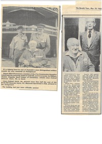
The first two clippings, date 29 March 1983, refer to the opening of the Puckapunyal Sportsman's Club and the third to the 1975 publication of Joynt's book 'Saving the Channel Ports - 1918'. Came from an album of items collected about the life of Legatee Joynt, Cat No. 01588. Highlights Legatee Joynt's long relationship with Melbourne Legacy and the esteem in which he was held.Black and white newspaper clippings x 3, two loose and one glued to a white paper sheet with two vertical red lines.donovan joynt, memorial -
Bendigo Historical Society Inc.
Map - MILLOO : COUNTY OF BENDIGO, 29-2-24
Map. Milloo, County of Bendigo. Wanurf, Dingee, Kamarooka, Pannoomilloo, Waranga Mallee Channel, Elmore to Kerang Road, Pannoo Estate. By authority A.J. Mullett, Govt. Printer. Photo-Lithographed at the Department of Lands and Survey, Melbourne, by W.J. Butson, 29-2-24. Price 1/-. Janiember to Rochester Road. (number 72 in map cupboard 1)A.J. Mullett, Government Printer.map, bendigo, milloo -
Port Melbourne Historical & Preservation Society
Film - Video Recording - Digital, Libby O'Farrell, Port to Paris, 22 Sep 2020
Digital video recording of PMHPS meeting held on 22 September 2020. In July 2103 Libby O'FARRELL became the 100th Australian and 25th Australian woman to successfully swim the English Channel. Libby shares with us her story on tackling one of the world’s most difficult swims, from swimming at night, to jellyfish, tankers, duck fat and teamwork.libby o'farrell, sport - swimming -
 Surrey Hills Historical Society Collection
Photograph, Hamilton Street, Mont Albert in 1919, 1919
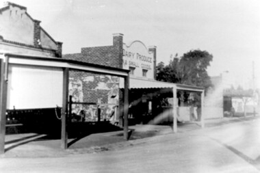
The land occupied by the Hamilton Street shops was subdivided in the 1880s and the first purpose-built shop was 'Pope and Moran, Grocers'. This shop later became Tom Morris' Grocery. By 1930 shops stretched along both sides of Hamilton Street and part way along Churchill Street. The donor the late Norman Carter took many photos documenting Mont Albert and Surrey Hills from the 1920s. His subject matter often related to Church of England events and activities.Black and white photo taken from the centre of the road in Hamilton Street, Mont Albert. Three single storey shops can be seen with vacant blocks of land in between them. They have verandas extending over the pavement to the edge of the road which appears to have bluestone curb and channelling. One shop sells dairy produce and small goods.hamilton street, shops -
 Surrey Hills Historical Society Collection
Photograph, Parade in celebration of King Edward VII's birthday, 1902, 1902
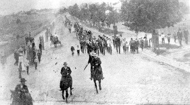
The parade was held in celebration of King Edward VII's birthday on 4 July 1902. This was the first public appearance of the German Band formed on 30 May 1902. The leading horseman is Mr Rowland Coe. He is followed by Mr George Robinson, a butcher of Canterbury Road. The man in the white hat is Mr Sam Kellett, businessman of Erasmus Street. Behind him on foot and partly obscured is Mr Alexander McNeill of the Surrey Family Hotel. Band master is Harry Pollard, painter and paper-hanger, and next to him is Constable Hill. The small boy in the sailor suit is Perc Venman of Essex Road and in the buggy near the footpath is Mr and Mrs William Maling. Information came from David Staig senior. Further research: William Saunders Maling, a son of John Butler Maling, was a builder who lived at 17 Balwyn Road, Canterbury. Rowland Coe, a butcher and son of James and Elizabeth Coe of Sunbury Crescent enlisted in AIF in WW1. He later lived at 233 Elgar Road, Box Hill. William Percival Reginald (Perc) Venman was born in Surrey Hills in 1894; he died in Surrey Hills in 1951 and lived at 27 Essex Street for much of his life. He and his wife are buried in Box Hill Cemetery. The identity of Sam Kellett of Erasmus Street is questioned. Edward Kellett built 'Yielma' in Erasmus Street but was deceased by 1902. He had 3 sons: Edward Allan (1854-1932); George Henry (1858-1921) and William John (1865-1945).Black and white photo of a number of men on horses leading a parade down Station Street (Windsor Crescent) to Union Road. Street trees on the RHS are mature whilst the ones on the LHS look to be newly planted. They have wooden guards around them. The area to the left is blurry but would be the railway line and station surrounds. Roads are well formed with bluestone channels.parades and processions, bands, german band, windsor crescent, william saunders maling, mrs hannah maling, miss hannah miller, constable hill, perc venman, george robinson, sam kellett, alexander mcneill, rowland coe, harry pollard, william percival reginald venman -
 Darebin Parklands Association
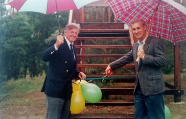
Cutting the ribbon of the new viewing deck, Tom Leigh Photographics, 1993-1994
The viewing deck was designed by Trevor House, architect.Colour photograph of Councillor Vin Heffernan (left) and Rob Gell, Channel 9 & 7 weatherman (right) cutting the ribbon of the new viewing deck in Darebin Parklands This item and all other Darebin Parklands Association archival material is now held by State Library Victoria (Accession No: YMS 13746). Please contact State Library Victoria if access is required.Annotated with stickers on back. [1994/015541 case admin] -
 Darebin Parklands Association
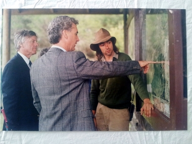
Inspecting the board on the occasion of the opening of the viewing deck, Tom Leigh Photographics, 1993-1994
The viewing deck was designed by Trevor House, architect. Colour photograph of Councillor Vin Heffernan (left), Rob Gell (Channels 9 & 7 weather presenter, centre) and Peter Wiltshire (Darebin Parklands Ranger, right). This item and all other Darebin Parklands Association archival material is now held by State Library Victoria (Accession No: YMS 13746). Please contact State Library Victoria if access is required.Annotated with sticker on back. -
 Melbourne Tram Museum
Photograph - Black & White Photograph/s, Mal Rowe, Sep. 1971
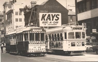
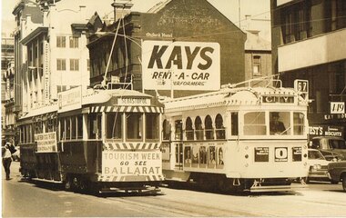
Black and white Photo of Ballarat 36 and W7 1024 in advertising livery for Channel O. Tram 36 has destination of 36 and 1024, City, running route 67.. In the background is Addressograph Multigraph, Oxford Hotel and Kays Rent - A - Car office at 449 Swanston St.. September 1971. 2nd copy with details written on the rear by Keith Kings.On rear is the "M. Rowe Copyright Photograph No. 2"trams, tramways, swanston st, ballarat tourism, tourism, w7 class, advertising trams, tram 36, tram 1024 -
 Lakes Entrance Historical Society
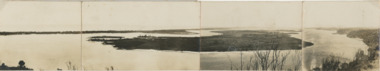
Postcard, Reeves Channel, Rigby Island, the entrance, Bullock Island , Lakes Entrance Victoria, 1920 c
Views of Gippsland Lakes from Jemmy's Point Lakes EntranceBlack and white panoramic folding postcard of the Gippsland Lakes including Reeves Channel, Rigby Island, the entrance, Bullock Island and Lakes Entrance township taken from Jemmys Point Lakes Entrance Victoria. Also panoramic postcard view from southern part of Rigby Island to Lakes Entrance township. And a third postcard "KALIMNA COVE LAKES ENTRANCE"waterways, gippsland lakes -
 Vision Australia
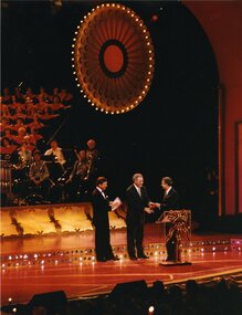
Photograph - Image, Ray Martin and Doug Kent on stage at 1998 Carols by Candlelight, 24/12/1998
Doug Kent shakes hands with a major sponsor, whilst Ray Martin looks on. Possibly corporate sponsorship thanks for Channel 9 or Myer Melbourne who have supported the event in recent years. With two other images of Doug Kent and major sponsor addressing the crowd.3 x col. photographs of Ray Martin and two other men on the Carols by Candlelight stage.CBC-96-5-13A (7137) CBC-96-5-10A (7138) CBC-96-5-3A (7139)carols by candlelight, ray martin, doug kent -
 Port of Echuca
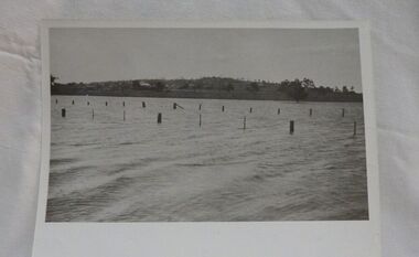
A black and white postcard, 1906. or. 1916
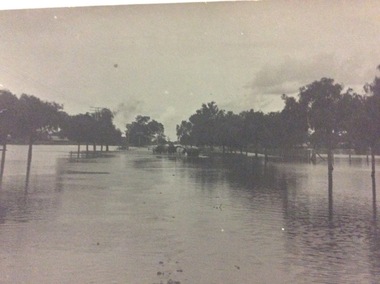
The postcard is significant because it shows the extent of the flood in the early 20th Century. The bridge crosses the Southern Cross channel which had been built as part of the Murray Darling irrigation system. There is a vehicle on the bridge either being towed by bullocks or horses. Floodwaters cover the whole view.The postcard is significant because it shows the extent of the flood in the early 20th Century. The bridge crosses the Southern Cross channel which had been built as part of the Murray Darling irrigation system. It is also near the water filtration plant which filters the town's water supply. There is a vehicle on the bridge either being towed by bullocks or horses. Floodwaters cover the whole view.A black and white postcard showing Goulburn Road, Echuca East, in either the 1906, or 1916 floods.Printed on the back are the words; W. Grimwood Echuca. POST CARD. Correspondence Address Only Kodak Australia. Hand written on the back are the words 1906 or 1916? Southern Cross bridge near filtration plant. Goulburn Road, Echuca East.floods, goulburn road, echuca east, pullicino, j, postcard, southern cross channel, water filtration plant -
 Ballarat Tramway Museum
Photograph - Ballarat 36 and Melbourne W7 1024 Swanston St, Mal Rowe, 9/1971
Photo of Ballarat 36 and W7 1024 in advertising livery for Channel O. Tram 36 has destination of Sebastopol and 1024, City, (route 67).. In the background is Addressograph Multigraph, Oxford Hotel and Kays Rent - A - Car office at 449 Swanston St. Mid to late September 1971. Has a strong association with a Melbourne tram driver who assembled the scrap book and series of photos of Ballarat trams at the time of closure, with the original photographer and the event of a Ballarat tram running in Melbourne to promote Ballarat tourism after the closure of the Ballarat tram system.Black and white photograph contained with Reg item 5988, a Stamford Kiwi School Scrap Book - card covers, 23 sheets, spiral bound, titled "Ballarat", prepared by Ellen Butland of Auckland following the closure of the SEC Ballarat Tramway system.On rear is the "M. Rowe Copyright Photograph No. 2"closure, trams, tramways, ballarat, tram 36, swanston st, tourism, tram 1024, channel 0, kays rent a car -
 Wodonga & District Historical Society Inc
Functional object - Sanyo 'Sensor Touch' Colour Television, Sanyo Australia Pty. Ltd, c. 1980s
The Sanyo ‘Sensor Touch’ television was assembled in Wodonga. Sanyo was one of the international companies that set up business in Wodonga in the 1970s as part of the decentralisation of industry. It continued operation into the 1980s. The Sanyo Australia Pty. Ltd. factory in Wodonga opened in 1974 with 35 staff and production peaked in 1976-1977 when it employed 360 people. In the first ten years 350,000 televisions were assembled from Japanese parts, however by 1984 the number of staff had reduced to 112 and the factory closed in 1987. All Sanyo televisions were then imported from Japan.The Sanyo ‘Sensor Touch’ television has local, state and national significance as it is thought to have been assembled in Sanyo Australia's factory in Wodonga. Sanyo was one of the international companies that set up business in Wodonga as part of the decentralisation of industry in Australia in the 1970s-1980s.Large Sanyo 'Sensor Touch' colour television with a faux wooden veneer frame and exterior. 53 cm or 20 inch screen (diagonal measurement)."SANYO / Sensor Touch / Telecolor" on the proper left side panel. "9 / 2 / 7 /28 /10 / 3 / 1 / 0 / AV" for the channels on the proper left panel. "COLOUR / BRIGHT / ONE / BUTTON / COLOUR / PULL-ON / VOLUME" under various buttons on the proper left panel. sanyo, colour televisions, televisions, sensor touch television, wodonga, sanyo australia pty. ltd. -
 Federation University Historical Collection
Postcard - Sepia, The Diving Stone in the Great Roman Bath, Bath, Somerset
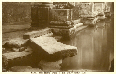
The Great Bath is a massive pool, lined with 45 sheets of lead, and filled with hot spa water. It once stood in an enormous barrel-vaulted hall that rose to a height of 40 metres. For many Roman visitors this may have been the largest building they had ever entered in their life. The bath is 1.6 metres deep, which was ideal for bathing, and it has steps leading down on all sides. Niches around the baths would have held benches for bathers and possibly small tables for drinks or snacks. A large flat slab of stone is set across the point where hot water flows into the bath. It is known today as the diving stone. The Roman Baths complex is a site of historical interest in the English city of Bath. The house is a well-preserved Roman site for public bathing. The Roman Baths themselves are below the modern street level. There are four main features: the Sacred Spring, the Roman Temple, the Roman Bath House and the Museum, holding finds from Roman Bath. The buildings above street level date from the 19th century. Sepia postcard of a section of the Great Roman Bath at Bath, Somerset featuring the Diving Stone.printed verso: The Diving Stone in the great roman bath. The Diving stone, at the north-west corner of the great Roman Bath, still shows where the feet of bygone bathers wore away its surface. The hot mineral waters flowed into the bath through a channel under this stone. chatham-holmes family collection, bath, great roman bath, swimming pool -
 Wycheproof & District Historical Society Inc.
Photograph, Mr Ernie Taylor, Cooroopajerrup Creek 1923, 1923 (exact)
The semi-mythical stream, the Cooroopajerrup Creek. Before there were any channel banks and formed roads, this creek shared the Avoca flood waters with the Tyrrell Creek. In more recent times the Wycheproof channel prevented the major floods of 1956 and 1973 from following the old river course. Also there is said to have been some shifting of the sand-hills at Teddywaddy which have blocked much of the old Cooroopajerrup flow. Little is known of earlier records, but The Mount Wycheproof Ensign records flooding of the creek in 1909. 2011 saw the Cooroopajerrup flow again after 88 years. This 2011 photo was taken at about the same position as the 1923 photo. The modern steel roadway fence is submerged. see-Photograph-Record No 001997.Copy of a B&W photograph of the Cooroopajerrup-Creek in flood-1923. To the north is Mount-Wycheproof, with the hospital barely visible behind the trees just left of centre, and a few scattered dwellings. The nearer railway-fence follows the road leading to the current saleyards.The outer fence has been replaced with a modern steel fence.None1923, cooroopajerrup creek, flood, mount wycheproof -
 Kiewa Valley Historical Society
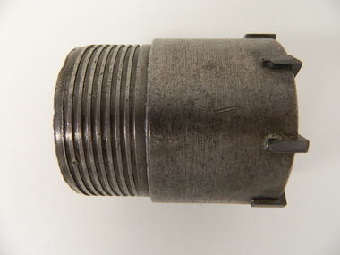
Drill Bit Diamond, circa mid to late 1900's
This hollow core bit has hard cutting inserts for drilling into rock. It was used to drill and recover 50mm diameter (most common size) rock cores. The rock cores were assessed by geologists and engineers to provide information for design of structures such as tunnels, dams and underground power stations (eg. McKay Creek Power Station, West Kiewa Power Station). This type of bit was also used where damage to the surrounding rock had to be minimised. The Diamond Drill Bit,used in the early 1900's, when it was primarily used as a method of sampling rock for ore deposits and oil exploration resulting in a "coring" of rock. The use of "coring" to obtained samples for the SEC Kiewa Hydro Electricity Scheme(1920's onward) was to analyse the core to obtain temperature and rainfall patterns shown by the levels of layered solidified soil(rock). This diamond drill would have been used in the early 1900's to provide a sub strata map of temperature and water patterns (over an long period of time). This was a pre requisite to any decisions about the viability of the region to provide the water needed for a successful hydro electricity scheme.This diamond drill for core sampling was at the forefront of the analysis whether to construct a hydro electrical facility in the Kiewa Valley and the adjoining alpine region. The rock core samples produced were assessed by geologists and structural engineers. It was only after extensive core drilling covering the region that solid scientific evidence could be provided to start the "SEC Vic Hydro Electricity Scheme" within its current boundaries.This "diamond" drill bit has eight "teeth" at its cutting edge. The drill creates an 55mm hole in extremely hard rock material to obtain 50mm core samples.. Three quarters down the shank it has thread screw channels to attach the bit to the drill pipe. The coring pipe attaches via screwing it onto this bit. Core samples are the main objective of this tool.alternate energy supplies, alpine feasibility studies temperature, rainfall, sec, kiewa hydro electric scheme, electricity -
 Bendigo Historical Society Inc.
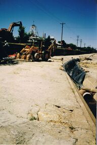
Photograph - CASTLEMAINE GAS COMPANY COLLECTION: PHOTO WATER CHANNEL
Water channel, 2 excavators, worker climbing ladder. Poppet head of a mine in background, Rubber tyred tractor with blade and trencher fitted in creek bed, larger excavator is adjacent to the tractor on the left bank, light posts and wire along the left bank, central gutter has plastic laid for a short distance, Pipe held down with sandbags in centre gutter.Kodakorganisation, industry, gas and fuel -
 Bendigo Historical Society Inc.
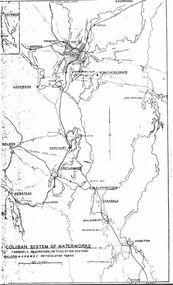
Map - STATE RIVERS AND WATER SUPPLY COMMISSION : COLIBAN SYSTEM OF WATERWORKS MAP
State Rivers and Water Supply Commission. Photocopied foolscap-size map. Title: Coliban System of Waterworks. Channels, reservoirs, reticulation systems. Maldon - S.R. & W.S.C. reticulated towns. The map includes the areas from Goornong to south of Kyneton and across to Maldon: Goornong, Marong, Bendigo, Strathfieldsaye, Lockwood, Maldon, Harcourt, Castlemaine, Newstead, Elphinstone, Taradale, Malmsbury, Kyneton.state infrastructure, water supply, coliban system, state rivers and water supply commission. coliban system. -
 Lakes Entrance Historical Society
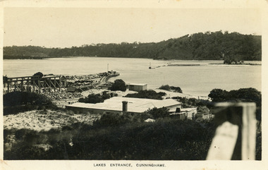
Postcard - New Works, Bulmer H D, 1910c
Also second copy same sizeBlack and white postcard showing view of Works buildings and north end of eastern pier. Cunninghame Arm and tip of Bullock Island and groyne work on right. Reeves channel and tip of Rigby Island on left. Mt Barkly and Kalimna Hills in background. Photo taken from top of dune. Roof of Carstairs boarding house centre foreground. Lakes Entrance VictoriaLakes Entrance, Cunninghamewaterways, settlement, historic buildings -
 Lakes Entrance Historical Society
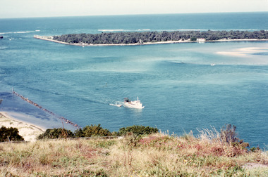
Photograph - The Entrance, Fraser, Ian, 1990c
Colour photograph of the lake. It shows a fishing boat with scallop dredge moving up the lake opposite the artificial entrance, grassy edge of Jemmy's Point in foreground above highway guard fence, rock groyne at entry to North Arm, sandy shallows at entry to Hopetoun Channel, scrub covered hummocks of south shore and Bass Strait in distance. Lakes Entrance Victoriaislands, waterways, topography -
 Kiewa Valley Historical Society
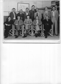
Photos - 1. Mt Beauty R.S.L. Committee 1949-1950 2.ANZAC service at Mt Beauty cearly 1950s
R.S.L. is the Returned and Services League of Australia, a member based charity founded in 1916, and the largest veterans' charity in Australia. It provides a support network and community for veterans and their families. They have a commemorative service each year on 25th April, ANZAC Day.The Mt Beauty RSL committee members in 1949 is a list of people living in Mt Beauty at the time and who were working as a support team for veterans and their families. The ANZAC crowd at the temporary memorial indicate the interest in the town for a commemoration and the need for a more permanent structure.Both Black & White large photos. 1. Group of men - Mt Beauty R.S.L. Committee with names on reverse. 2. Anzac Day at Mt Beauty. Early 1950s. People including school children, gathered around a temporary war memorial structure near the current (2023) roundabout. In the background is the main workshop. The Tail race channel hasn't been constructed. On the back in pen of RSL photo: Mt Beauty R S L Committee 1949 -50 / Standing Fred De Little, Roy Cobby, WaJ. Jones/ Joe Lang, Ian Bennett, Stan Leanard, Ted White/ Seated / Harry Edney, Jack Chapman (Tres), Harold Boon (Pres), R Webster (Sec), /Joe Breen returned services league, anzac day, rsl 1949 -
 Bendigo Historical Society Inc.
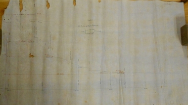
Document - MARKS COLLECTION: SECTION OF MAIN CHANNEL
Plan drawn on waxed type paper, fragile. Written in centre of map 'Section on Centre of Main Channel, Scale horizontal 2 chs, vertical 10ft., to an inch'. Plan shows Melbourne Road on top section. Written in red ink '5,000,000 galls in 24 hours = 3472.2 gals per minute'. Plan located in documents from George Lansell auction.bendigo, mining, water channel section -
 Uniting Church Archives - Synod of Victoria
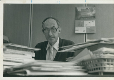
Photograph, Rev. Warren Clarnette, Editor of Church & Nation, Undated
Ordained 1958. Huon-Channel 1955-57; Queenstown 1957-58; Devonport 1958-61; Ballarat East 1962-66; W/S 1966-68; Carnegie 1968-70; Dept of Communication 1971-77; Board of Communication 1977-? Concluded as Editor of C&N February 1988.Clarnette, taken looking at him across his paper-laden desk."Warren Clarnette" and reference to C&N.clarnette, warren, church & nation -
 Uniting Church Archives - Synod of Victoria
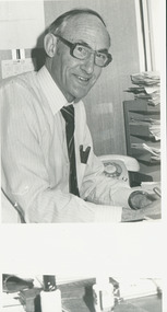
Photograph, Rev. Warren Clarnette, Editor of Church & Nation, 24/09/1986
Ordained 1958. Huon-Channel 1955-57; Queenstown 1957-58; Devonport 1958-61; Ballarat East 1962-66; W/S 1966-68; Carnegie 1968-70; Dept of Communication 1971-77; Board of Communication 1977-? Concluded as Editor of C&N February 1988.Side view of Clarnette sitting at his desk."Warren Clarnette" and reference to C&N.clarnette, warren, church & nation -
 Kiewa Valley Historical Society
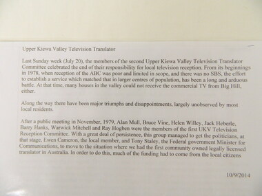
History of the Upper Kiewa Valley Television Translator, 1970's to 2014
The Television Translator was set up for people in the Upper Kiewa Valley who couldn't access the ABC, SBS and other channels of television from other transmitters in the area. Black spots were funded in 1999-2000. In 2014 new digital equipment resulted in the folding up of the committee and SBS took over.Historical: The history of providing television in the Upper Kiewa Valley to all residents and that of a community who worked towards achieving their aim. The history of technology for delivering television to people.A full box consisting of folders and papers relating to the History of the Upper Kiewa Valley Television Translator.television translator. upper kiewa valley. abc. sbs.