Showing 829 items
matching computers
-
 Orbost & District Historical Society
coloured photographs, Snowy River Mail, second half 20th century
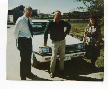
3098.28 is associated with Orbost Education Support Centre Country Education Project. It shows Helen Shiel and two men. 3098.29 is of a group working at desks with computers. One lady is standing. 3098.30 is a demonstration of Hi Tech for teachers and parents at the East Gippsland Conference and Expo at Bairnsdale. Joan Mehlert is in the photograph. 3098.31 shows a group of students of the Comm Skills 1 Evening Class. 3098.32 is associated with the Country Education Project Ruskin Street, Orbost.These photographs are associated with Adult Learning in Orbost.Five coloured photographs related to adult education.education-adult-learning-orbost country-education-project -
 Kiewa Valley Historical Society
Book - Ledger Commercial, Ledger No 5, Commenced Jan 1st 1897, circa 1890's
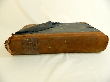
Historically this ledger not only details the legible hand writing of this era but also the day to day commercial activity in this region. The neatness and the diligence of those who were required to pen the information was a requirement by all who were in commercial trade. Emphasis on neatness was ingrained in students at a young age. This era was well before general typewriters and computers. Generally all students of commerce required an accuracy in writing and arithmetic. Neatness and order were a selection requirement This item clearly identifies the Kiewa Valley as having a substantial financial hub to accommodate the various commercial enterprises within a rural environment Circa 1880's. Although Kiewa Valley had mining, agriculture, cattle and sheep it was also composed of a mixed society, encompassing all levels of society at that period. It identifies some family farming history in the specific year of 1897Leather reinforced corner covers and spine. Remaining book front and back covers are protected by blue weaved cloth. The covers are very thick cardboard, in layers. Missing front index pages C,E - 0,Q,T,U,V,XSpine of book marked in faded golden print "Ledger". First page in hand writing "Ledger No. 5" and underneath handwritten "Commenced Jan 1st !897" After the index pages each page (double sided) has a page number stamped in black and is 6mm highledger, early bookkeeping, local history, commerce circa 1890 -
 Port Melbourne Historical & Preservation Society
Functional object - Shopping Bag, Bay Street Traders Association, 2001
Produced by and for the Bay Street Traders Association. .01 was produced first and printed on clear plastic, which made the images unreadable. Hence .02 was produced and printed on white plastic. Note that the 2000 scene is a computer generated image of what Bay Street may look like in the future, not as actually was in 2001. Similarly, the scene portrayed for 1800 does not reflect any reality as Liardet only landed at Sandridge in 1839. It may be an 1890s view.Black and white plastic promotional bag produced by the Bay Street Traders Association, purporting to show scenes of Bay Street in 1800 (sic) and 2000. Bears the Association logo.advertising, business and traders, bay street traders association, bay street -
Port Melbourne Historical & Preservation Society
Functional object - Shopping Bag, Bay Street Traders Association, 2001
Produced by and for the Bay Street Traders Association . .01 was produced first and printed on clear plastic, which made the images unreadable. Hence .02 was produced and printed on white plastic. Note that the 2000 scene is a computer generated image of what Bay Street may look like in the future, not as actually was in 2001. Similarly, the scene portrayed for 1800 does not reflect any reality as Liardet only landed at Sandridge in 1839. It may be an 1890s view.Black on clear plastic promotional bag produced by the Bay Street Traders Association, purporting to show scenes of Bay Street in 1800 (sic) and 2001. Bears the Association logo.advertising, business and traders, bay street traders association, bay street -
 Bendigo Military Museum
Poster - Map Production flow chart poster using Automap 2, Army Survey Regiment, Bendigo, 1982
This poster designed to be folded into a brochure describes the second phase of the computer assisted cartographic system to be used by the Royal Australian Survey Corps in the establishment of a topographic data base, Future tactical applications and map products using the data base are displayed. A topographic map of Series R631 1:100,000 Helenvale, Queensland printed on the reverse side that was produced by the Automap system using information from the topographic data base. This is the fifth edition of the poster.A multi colour poster of map production using the Automap 2 system. Poster shows a schematic and pictorial flow chart diagram of the stages of the map production process using the Automap 2 system. The poster was intended to be folded into a small brochure. A 1:100,000 Army Survey Map Series R631, 7966 Helenvale, Queensland Edition 2 is printed on the reverse side of the poster. The map is an example of one of the initial maps produced on the Automap 2 System at the Army Survey Regiment, Bendigo.royal australian survey corps, rasvy, fortuna, army survey regiment, army svy regt, asr, automap 2 -
 Halls Gap & Grampians Historical Society
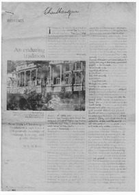
Document - Fax of article (magazine/newspaper)
The article is c.1993. Chautauqua peak is named after the Chautauquans, who held summer camps in Halls Gap in the 1890s. NOTE: Additional images are second and third pages, and a Microsoft Word file which includes the text of all three pages. A PDF file of an "augmented copy of the fax (with the more difficult to read sections clarified in pencil) is also available in the \Pictures\MP Navigator\2009_09_-02 directory on the computer (as there is not further space to attach it to this record)A copy of a three page National Geographic Traveler article entitled 'An enduring tradition'. The article describes the reporter's trip to Lake Chautauqua where the Chautauqua Institution was founded, and includes historical information about the Chautauquans.Chautauqua written in ball-point pen on top of front page.media, magazine articles -
 Queenscliffe Maritime Museum
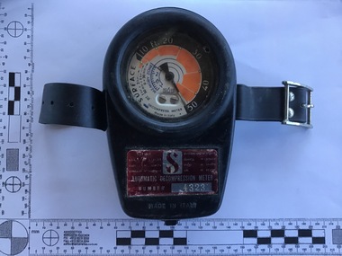
Equipment - The ScubaPro Automatic Decompression Meter 1966 in original box
First available in ScubaPro’s catalogue in 1966, the ScubaPro Automatic Decompression Meter was a break through in diving technology and a forerunner to the modern dive computer. The meter attempted to calculate nitrogen absorption based on dive time and depth. This was done mechanically instead of electronically, and without the benefit of any actual computing. The Automatic Decompression Meter was introduced just a year after ScubaPro’s most successful product – the ScubaPro Jet Fins – which still remain popular today. Used by divers since 1966The ScubaPro Automatic Decompression Meter 1966 in original box Automatic Decompression Meter Number 4323 made in Italydiving, decompression meter, scubapro -
 Ballarat Tramway Museum
Newspaper, Paul Nolan and Glenn Shields, "Jenkins calls for tourist trolleys on our streets", 26/2//1997
Article in The Courier, Ballarat 26/2/1997, page 3, written by Paul Nolan reporting on the proposals by Paul Jenkins MLA for Ballarat West that motor buses dressed as "trolleys" be used to transport visitors around Ballarat prior to the reintroduction of trams to Ballarat streets. Features a computer image by Glenn Shields of on the Disneyland "trolleys" superimposed on the photo of the Ballarat Town Hall. (btm1511i1) and a cartoon by Burns (btm1511i2)."Wednesday February 26 1997 pg3" in blue ink along top right hand edge.tourist bus, ballarat city tramway, ballarat revival, disneyland -
 Bendigo Historical Society Inc.
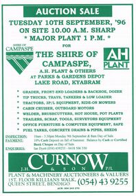
Document - IAN DYETT COLLECTION: AUCTION CATALOGUE - THE SHIRE OF CAMPASPE, A H PLANT & OTHERS
White catalogue with green printing for a sale on the 10th September, '96 on account of The Shire of Campaspe, A. H. Plant & Others. For sale were tip trucks, grader, tractors, cabin cruiser, welder, garden equipment, scrap, tools, surveyors equipment, office furniture, computer equipment, safe, fuel tanks, concrete drains & pipes and sheds. J. H. Curnow & Son P/L were the auctioneers.business, auctioneers, j h curnow & son pty ltd, ian dyett collection - auction catalogue - the shire of campaspe a h plant & others, ian dyett, j h curnow & son p/l, noel dyett, fred dyett -
 Bacchus Marsh & District Historical Society
Map, Plan of land purchased by the Bacchus Marsh Shire Council from Mr. T. Low for a deviation of the Melbourne to Ballarat main road. 1877
The date of this plan is 1877 and the land indicted on it required for a road deviation is shaded in blue. It adjoins the Korkuperrimul Creek on one side which indicates the land is located just a few kilometers to the west of Bacchus Marsh. Single page map showing a portion of land purchased by the Bacchus Marsh Shire from Mr Thomas Low for the purpose of a road deviation. Land held by David Robertson is also shown on the map. Scale: 2 chains to 1 inch. Part of a set of maps which are pasted into a bound volume containing 76 maps or plans in total. High resolution digital image stored on BMDHS computer network. Surveyed by W. E. Standfield, Shire Engineer, Bacchus Marsh, 12/4/77bacchus marsh roads and streets, melbourne to ballarat road -
 Bacchus Marsh & District Historical Society
Map, Gaynor Street Area Land Sales, Maddingley, 1888
This map was produced for a major sale of land in the Maddingley area of Bacchus Marsh in 1888. The sale was conducted by two firms from Melbourne, Carney and Kelly 12 Swanston Street Melbourne. and 'Richardson, Kerr & Co. 40 Flinders Lane Melbourne. 136 blocks were for sale.A single page paper map showing land allotments for sale in the Maddingley area of Bacchus Marsh. Locations shown include Gaynor Street, Maddingley Road South, Parwan Road, Mitchem Street, Typpynge Street, Finn Street and East Maddingley Road. . The map is pasted into a bound volume containing 76 maps or plans in total. High resolution digital image stored on BMDHS computer network. bacchus marsh victoria maps, maddingley victoria maps, land use, maddingley victoria history, land sales bacchus marsh, land sales maddingley -
 Bacchus Marsh & District Historical Society
Map, Gaynor Street Land Sales, Maddingley, circa 1880s-1890s
This map was produced for a major sale of land in the Maddingley area of Bacchus Marsh. The precise date of the sale has not been determined. Features present on the map such as the Bacchus Marsh Railway Station indicate the land sale must have taken place some time after 1887 when the Railway Station opened. A single page paper map showing land allotments for sale in the Maddingley area of Bacchus Marsh. Locations shown include Gaynor Street, Maddingley Road South, Parwan Road, Mitchem Street, Typpynge Street, Finn Street and East Maddingley Road. . The map is pasted into a bound volume containing 76 maps or plans in total. High resolution digital image stored on BMDHS computer network. bacchus marsh victoria maps, maddingley victoria maps, land use, maddingley victoria history, land sales bacchus marsh, land sales maddingley -
 Melbourne Tram Museum
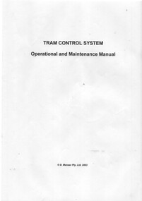
Document - Instruction Book, B. Manser Pty Ltd, "Tram Control System - Operation and Maintenance Manual", 2003
Instruction Book - 20 pages contained with a clear plastic cover and black retaining block or strip, titled "Tram Control System - Operation and Maintenance Manual", giving details of the system to control tramcars within depots, which tracks, timetables, dispatching, computer system, caters for run-ins, varying lengths and other criteria. Has copyright - B. Manser Pty Ltd 2003 on front cover.trams, tramways, depots, depot trackwork, tramcars, instructions, depot starter, software -
 Melbourne Tram Museum
Photograph - Digital Image, Kevin O'Reilly, Kew Junction from the north east, towards the city, c1930's
Image from CD (Compact Diskette for use in computers) - see Reg Item 135. Image titled "Kew Junction' on CD, of looking Kew Junction from the north east, towards the city, shows the Kew railway station precinct. Has a inbound W class tram picking up passengers at the Kew Post Office. A summer day. Possibly late 1920's, early 1930's.trams, tramways, kew, kew junction, kew post office, high st -
 Melbourne Tram Museum
Photograph - Digital Image, Kevin O'Reilly, Richmond looking east along the Yarra River, c1930's
Image from CD (Compact Diskette for use in computers) - see Reg Item 135. Image titled "Richmond 7" on CD, of looking east along the Yarra River where the Church St Bridge Richmond crosses the River, Alexandra Ave. Has an ex HTT Maximum Traction tram crossing the bridge. Shows now Herring Island after the Yarra River was cut through to form the island.trams, tramways, richmond, chapel st, church st, yarra river -
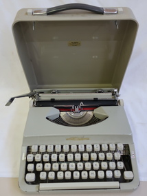 Kiewa Valley Historical Society
Typewriter - Portable
These typewriters were imported fully assembled from Japan by CFM Industries. CFM (Curvie Furniture Manufacturing). The Nakajima portable typewriters were imported in the 1970s. Typewriters replaced hand written writing. Their benefits were that the work was written faster and was legible. The portable typewriter enabled the typist to take her typewriter with her. Typewriters have now been replaced by computers with the advantage of editing the work before the final copy is made and with the ability to add eg. photos, create different settings etc. Used by a resident of the Kiewa Valley in the 1970s.Beige hard plastic case with dark grey handle with chrome fittings and white buttons either side of the handle. Metal typewriter 'querty' key board, white keys with black inscriptions. Includes typewriter ribbonLabel inside cover for servicing. "CFM Industries Pty Ltd address, phone number" Label on back of typewriter for CFM Industriesportable typewriter -
Vision Australia
Audio - Sound recording, Vision Australia, Around Vision Australia: Episode 47
Covering issues and news about Vision Australia and the opportunities it provides for clients, volunteers and staff. Host: Stephen Jolley with guest interviews by Valerie Thomas. Robyn McKenzie chats with Peter Lee from Computer Aided Transcription Office, talking about producing braille. Andrew Thurley updates about new titles in the Library. Valerie Thomas interviews VA client Patrick Moore. Kate Gniel speaks about the retirement of Mike Janes and Malcolm Daubney from the Board.1 digital sound file in WAV formatradio shows, vision australia, robyn mckenzie, peter lee, andrew thurley, valerie thomas, patrick moore, kate gniel, mike janes, malcolm daubney -
Federation University Historical Collection
BTV6, State Data Cente BTV6 Newsclip, 1990, 1992
... Computers ...MP4 of State Data Cente BTV6 Newsclipballarat technology park, john sharpham, mt helen, ballarat university college, state data centre, computers, frank sheehan, david kennedy, ian smith, digital mapping project -
 Bacchus Marsh & District Historical Society
Map, Subdivision of the Manor House Property Bacchus Marsh c.1908
This land sales plan shows allotments of land offered for sale in the inner township area of Bacchus Marsh in 1908. The land put up for sale was from the estate of the late Mr and Mrs J.E. Crook. That being James Elijah Crook and his wife Harriet, (nee Athorn). The Crooks had been resident in Bacchus Marsh since the 1840s and were prominent members of the community. They were prominent in the business, social and civic affairs of the town and district. In the 1850s the Crooks acquired the Manor House and nearby land once owned by the Bacchus family. James Crook died in 1889. When Harriet Crook died in February 1908 their estate was offered for sale. This included the large stone home known as the Manor House and various parcels of land including around 50 allotments of land near the Manor House, bounded by Young, Lerderderg, Crook and Main Streets. Most of these allotments of land were sold in October 1908. The Manor House itself was passed in at the sale and continued to be owned by the Crook family for several decades after 1908.A single page map on a single page of a bound volume of maps. The map shows portions of land for sale from the subdivision of the Manor House property in Bacchus Marsh in 1908. The names of most of the buyers of the portions of land have been hand-written into the various allotments they purchased. The maps are pasted into a bound volume containing 76 maps or plans in total. High resolution digital image stored on BMDHS computer network. bacchus marsh victoria maps, land sales bacchus marsh, manor house bacchus marsh, crook family bacchus marsh -
![Map, Plan of Subdivision [Allotments along Lerderderg, George and McFarland Streets]](/media/collectors/5e461d8021ea67224c82f2a1/items/675d7243165f146b8adfc656/item-media/675d72d7165f146b8adfc859/item-fit-380x285.jpg) Bacchus Marsh & District Historical Society
Bacchus Marsh & District Historical SocietyMap, Plan of Subdivision [Allotments along Lerderderg, George and McFarland Streets]
This map shows allotments of land on the northern side of Lerderderg Street from Gisborne Road through to the approximate site of the present day Bacchus Marsh Primary School. There are also allotments shown on the southern side of McFarland Street between George Street and Gisborne Road. Larger allotments of land are shown extending northwards towards Masons Lane. Inscribed at the top of the map are the words, 'Plan of Subdivision of Cr Pors (Crown Portions) 12 & 13 & Allotments 1,2,3,4, Block 3, Parish of Korkuperrimul, County of Bourke'. The date of the map has not been established but the absence of the Bacchus Marsh Primary School on the map suggests it may have been produced prior to 1865 when the primary school was built in Lerderderg Street.Single page map showing house block size land allotments in the Lerderderg, George Street and McFarland Street area of Bacchus Marsh with larger allotments north of this area towards Masons Lane also shown. Scale 150 feet to 1 inch. Part of a set of maps which are pasted into a bound volume containing 76 maps or plans in total. High resolution digital image stored on BMDHS computer network. bacchus marsh victoria maps, lerderderg street land allotments, mcfarland street land allotments -
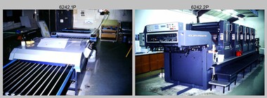 Bendigo Military Museum
Photograph - Print Troop Equipment, Lithographic Squadron – Army Survey Regiment, Fortuna, Bendigo, c1990s
This is a set of 25 photograph of Print Troop Equipment in Lithographic Squadron, Army Survey Regiment at Fortuna, Bendigo, 1990. Photo .1P features the new Howson Algraphy Autoneg printing plate processor. It improved quality control and efficiency and allowed the conversion of printing plates for positive or negative use. The Heidelberg Speedmaster 102 shown in photos .2P to .4P was a computer-controlled five colour lithographic offset printing press. It provided the Royal Australian Survey Corps a vastly improved printing capability, as the five colours for a standard topographic map was printed in a single pass. The print room housing the Speedmaster printing press was named Wayzgoose Hall after a medieval printing house festival. Wayzgoose Hall and the Speedmaster printing capability was commissioned by the Commander of the 3rd Military District BRIG P. Davies AM, ADC on Wednesday 27th June 1990. This occasion is covered in more detail in page 145 of Valerie Lovejoy’s book 'Mapmakers of Fortuna – A history of the Army Survey Regiment’ ISBN: 0-646-42120-4. For additional photos, refer to item 6062.4P for more photos of the Heidelberg Speedmaster printing press. The Print Room’s Map Assessment and Colour Evaluation Stations in photos .5P to .12P provided the Printer Technician suitable viewing environments to perform quality assessments of map samples. See item 6151.34P for more information and photos of technicians using the equipment. The Print Room’s Map Handling Station in photo .15P to .20P provided ergonomic benefits to the Printer Technician and improved despatching productivity. See Item 6070.9P for more information and photos. The Wohlenberg MCS-2 guillotine seen in photos .21P & .22P was a heavy-duty guillotine integrated component of the Map Handling Station, to trim bulk printed map stock. See item 6069.6P for more information and photos of earlier types of guillotine equipment. This is a set of 25 photograph of Print Troop Equipment in Lithographic Squadron, Army Survey Regiment at Fortuna, Bendigo, 1990. The photographs are on 35mm colour slides and were scanned at 96 dpi. They are part of the Army Survey Regiment’s Collection. .1) - Photo, colour, c1990s, Howson Algraphy Autoneg printing plate processor .2) to .4) - Photo, colour, 1990. Heidelberg Speedmaster 102 computer-controlled five colour lithographic offset printing press .3) to .10) - Photo, colour, c1990s, Heidelberg Speedmaster CPC 1-04 control unit. .11) to .12) - Photo, colour, c1990s, Map Colour Evaluation Work Station. .13) to .14) - Photo, colour, c1990s, Linear printing plate registration punch. .15) to .20) - Photo, colour, c1990s, Print Room’s Map Handling Station. .21) to .22) - Photo, colour, c1990s, Wohlenberg MCS-2 guillotine. .23) - Photo, colour, c1990s, Print Room Power supply equipment. .24) to .25P - Photo, colour, c1990s, Print Room Crown Fork Lift..1P to .25P - There are no annotations stored with the 35mm slides.royal australian survey corps, rasvy, army survey regiment, army svy regt, fortuna, asr, printing, litho -
 Kew Historical Society Inc
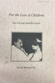
Book, For the Love of Children: my life and medical career / by David Buxton Pitt, 1999, 1999
Dr David Pitt was Australian paediatrician. In 1959, he joined the Kew Cottages workforce, where he practised for 17 years and improved the conditions for the children. He was a pioneer in the identification of rare syndromes using computers. The Cottages anabled him to contribute to the day to day care of disadvantaged people in the Australian community, while continuing his research. Pitt left Kew in 1976. (Source: Wikipedia). This book by David Pitt once formed part of the collection of Dr Cliff Judge, resident psychiatrist at the Cottages, and was donated by a daughter in 2018.xiv, 208 p. : ill., ports. ; 30 cm.mental health - victoria - history, chidren's cottages - kew, dr cliff judge, dr david pitt -
 Forests Commission Retired Personnel Association (FCRPA)
Instrument - Armstrong Rapid Log Calculator
Logs were sold to sawmillers from State forest from 1 July 1974 in cubic metres (true volume). Previously sawlogs had been sold on the basis of Hoppus volume. This simple device with two rotating wheels enabled staff in FCV offices to rapidly calculate log volumes from measurements taken in the bush of log girth and length and recorded on paper log dockets. From the early 1980s automated systems became available with the advent of cheap electronic office calculators and simple computers. An early manual device that was superseded by electronic calculatorsOffice Device Twin rollers used to quickly and simply calculate true log volumes using measurements of girth and length. An allowance could also be made for pipe defects. The top roller was for larger diameter logs.forest measurement, forests commission victoria (fcv) -
 Department of Energy, Environment and Climate Action
Armstrong Rapid Log Calculator
Logs were sold to sawmillers from State forest from 1 July 1974 in cubic metres (true volume). Previously sawlogs had been sold on the basis of Hoppus volume. This simple device with two rotating wheels enabled staff in FCV offices to rapidly calculate log volumes from measurements taken in the bush of log girth and length and recorded on paper log dockets. From the early 1980s automated systems became available with the advent of cheap electronic office calculators and simple computers.An early manual device that was superseded by electronic calculatorsOffice Device Twin rollers used to quickly and simply calculate true log volumes using measurements of girth and length. An allowance could also be made for pipe defects. The top roller was for larger diameter logs.Imperial measurement of logs (pre 1976)forests commission victoria (fcv), forest harvesting, forest measurement -
 Ballarat Tramway Museum
Photograph - Colour Photograph/s set of 5, Warren Doubleday, 19/01/2002 12:00:00 AM
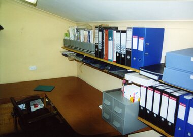
Set of four colour photographs of the interior of the BTM archives rooms taken after the room has been cleaned up, carpet washed (aqua vac), some shelving installed and boxes etc. returned to position. Computer had been removed for attention. Taken by Warren Doubleday on 20/1/2002. On Kodak paper. .5 - added 5/6/2009, photo by Carolyn Dean looking through the door, 6/8/1995.archives room, btm, collection management -
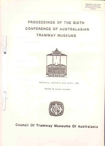 Ballarat Tramway Museum
Book, Tramway Museum Society of Victoria (TMSV), "Proceedings of the sixth Conference of the Australasian Tramway Museums, Melbourne July 24-27, 1982, 1982
Purple plastic ELBA folder, with 65 A4 sheets with plastic clip metal binding. Details the Proceedings of the sixth Conference of the Australasian Tramway Museums, Melbourne July 24-27, 1982. Edited by Graeme Breydon, published by the TMSV in 1982. Gives list of delegates, timetables, COTMA minutes, papers, - Learning from the Professionals - F. D. Snell - Computers in Museums - G. Breydon - Tour notes, note on Z class trams etc. Has Graeme Breydon name stickers on front cover and address label on front page.trams, tramways, cotma, conferences, tmsv -
 Bacchus Marsh & District Historical Society
Map, Allotments in the Village of Rowsley, Parish of Gorrocburkghap, County of Grant c.1856
Rowsley is a locality 11 kilometers south-west of Bacchus Marsh. The date of this map is uncertain. A very similar map held by the State Library of Victoria (SLV) contains slightly more information than this copy and is dated as an 1856 map. SLV reference: 'Allotments in the Village of Rowsley, Parish of Gorrocburkghap, County of Grant', by T. Nixon, Assistant Surveyor, May 1856 ; Surveyor General’s Office, July 18 1856 (lithographed by R. Meikle). (1856). Melbourne: Surveyor General’s Office. MAPS 820 BJE 1837- ROWSLEY 1856. A single page paper map. A cadastral map of the Village of Rowsley in Victoria, showing numbered land allotments. 57 allotments are shown on the map and some areas set aside as reserves. Allotments 8, and 10-16 are outlined in red ink and allotment 9 has a cross in red ink on it. The map is pasted into a bound volume containing 76 maps or plans in total. High resolution digital image stored on BMDHS computer network. rowsley victoria history, rowsley victoria maps -
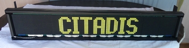 Melbourne Tram Museum
Functional object - Tramcar component, DUHAMEL?, Destination indicator equipment that was fitted to a C class tram - dot matrix style, c2000
Destination indicator equipment that was fitted to a C class tram - dot matrix style, set to the word "CITADIS" with inbuilt control equipment and computer control plugs. Installed within a metal box, with detailed wiring, plastic components and electrical components. Has a loose wire with two pin plug in the bottom left hand corner of the unit. Three labels on the rear control unit - no formal manufacturer name - perhaps DUHAMEL and other ID items.trams, tramways, destination indicators, c class, citadis, transport equipment -
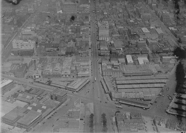 Melbourne Tram Museum
Photograph - Digital Image, Kevin O'Reilly, intersection of Elizabeth and Victoria Streets from the North, c1920, c1920
Image from CD (Compact Diskette for use in computers) - see Reg Item 135. Image titled "Eliz St" on CD, of looking at the intersection of Elizabeth and Victoria Streets from the North, c1920, between Swanston and Queen Streets. Has the Myer Lonsdale St store in the photograph at the top. Has a number of cable cars in the photo, including a bogie trailer inbound in Elizabeth St. Image has a number of watermarks showing up.trams, tramways, melbourne, elizabeth st, victoria market, victoria st -
Federation University Historical Collection
Book, Ballarat School of Mines Tertiary Orientation Programs, 1980, 1980
148 page yellow covered book outlining the Tertiary Orientation Programs offered by the Ballarat School of Mines in 1980. The courses offered were TOP Biology, Chemistry, Computer Science, Workshop Practice and Drawing, Home Economics, Applied MAthematics, General Mathematics (Computing Option), Pure Mathematics, Physical Education, Physics, Craft, Ceramics and Sculpture, Garment Construction, Graphic Communication, Graphic Design (including Design Studies and Printmaking), History of Art, Painting and Drawing, Drawing, Photography, Accounting, Advanced Typewriting, Economics, Legal Studies, Secretarial Studies, 19th Century Australian History, 20th Century Australian History, Australian Media, Behavioural Studies, Drama, English Expression, Field Studies, Film Studies, Introduction to Psychology, Literature, Music, Political Studies and Sociology. Programs were offered in Applied Science, Nursing, Physical Education, Home Economics, Engineering, Computer Science, Accounting, Secretarial, Humanities and Social Sciences, Art & Design and Fashion and Design.ballarat school of mines, tertiary orientation program, top, courses