Showing 624 items matching "deposit"
-
 Kew Historical Society Inc
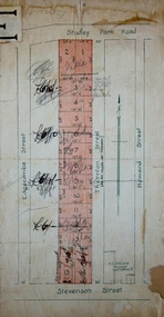
Plan - Subdivision Plan, Thornton Estate, 1918
The ‘Thornton Estate’ was the final subdivision of ‘Thornton’ in Studley Park Road. Thomas Cubitt Balmain originally owned Thornton, next to John Carson’s ‘Clutha’. Before its final subdivision, the Thomson family owned it. The Estate was a subdivision of 15 residential allotments running between Studley Park Road and Stevenson Street. The allotments faced these streets as well as Thornton Street, which the vendor undertook to make. Contemporary newspaper advertisements advised that ‘The estate possesses many advantages, notably its private and secluded, though convenient, position, splendid frontages and depths, and being close to the electric tram and Kew train, also within easy walking distance of the Victoria-street cable tram’. The terms offered purchasers were ten per cent deposit, with the balance to be paid in ten equal half-yearly payments at a rate of 5 per cent.subdivsion plans - kew, studley park, thornton estate -
 Bendigo Historical Society Inc.
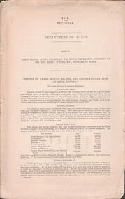
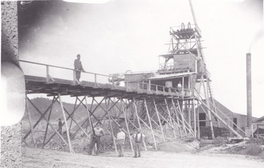
Document - GARDEN GULLY LINE OF REEF, LEASE BLOCKS 5360 AND 5361
Two page document titled ' Report on lease blocks Nos. 5360 and 5361 Garden Gully line of reef, Bendigo. Produced by the Department of Mines 1899. The area described is about 'one mile and a quarter southeast from the centre of the city of Bendigo, immediately south of the Great Southern Gold Mining Company's workings and is intersected by two auriferous gullies ... Salomon's Gully and Derwenter's Gully'. The alluvial deposits, the Garden Gully line, the Great Souther Co.and old workings are discussed in the paper. A map of the Garden Gully line of reef is attached to the report, showing claimholders and mine names along that section of the reef. Mines named on the map: Great Southern Garden Gully United Ulster Londonderry Burrows Horwoods Sea Amalgamated Garden Gully United Victory and Pandora Unity Carlisle and Garden Gully and Passbye United Cornish United Koch's PioneerJames Stirling, Government Geologistbendigo, mining, garden gully line of reef mines -
 Geoffrey Kaye Museum of Anaesthetic History
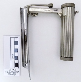
Tool - Laryngoscope, Magill, 1926
Ivan Magill (1888-1986) designer, this piece was designed in 1926 along with other anaesthetic equipment.Chrome plated straight complete Magill laryngoscope in medium size format, with attached light bulb. Cylindrical handle for battery deposit and with a wavy hand grip for easy handling. Serrated and screwed lids on top and base of the handle grip for insertion of batteries and checking of electrical contact stud. The handle also has a metallic switch without any instruction of use. The arm of the handle has a detachable screw to adjust extendable blade position and firmness. The light bulb is attached to a metallic tube connector to the handle arm which is just pressed to the contact point base. The blade has a oxidation spot under the blade. The piece in full has several scratches marks mostly founded in handle, arm and top blade areas. Two stamped inscriptions are present on the arm area, the manufacturer name and register number.Stamped on the arm of the handle lateral side, A.CHARLES KING Stamped on the arm of the handle opposite lateral side, REG. NO. 74901[9]magill, a. charles king ltd, regi. no. 749019, switch, laryngoscope -
 Ringwood and District Historical Society
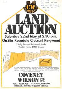
Flyer, Land Auction, Rosedale Crescent, Ringwood East - 1976
Single page advertisement for auction of 7 residential blocks in Rosedale Crescent, Ringwood on 22nd May, 1976.Vendor Terms $1,500 deposit. Agent - Covey Wilson Pty Ltd., Ashley House, 409 St.Kilda Road, Melbourne. Phone 2674022 AH 805062, 7892533. Handwritten notation "LP 97896 Vol 9038 Fol 283, seven available lots 9, 10, 11, 12. Other lots on request Res C." Lot 1 Council Reserve. Lot 2 PI 16750. Lot 7 PI 13250. Lot 8 PI 13350. Lot 9 PI 13500. Lot 11 PI 12750. Lot 12 Sold 13500(?). -
 The Beechworth Burke Museum
Photograph, 1857
This photograph is of old mine workings on the site of the Spring Creek diggings. Spring Creek is a contact zone for granite pluton and siltstones, shales and standstones; which has, over time, encouraged natural springs to form. Enriched with gold washed out of the surrounding granite, these alluvial deposits achieved fame from 1852 onwards as the Spring Creek Diggings sprang to life (not realised as geographically important until 1871). In Spring Creek that runs behind the main street of Beechworth, near the foot of Newtown Hill a pint pot of gold was discovered on one of these expeditions in 1852 by prospectors Baker and Strickland and the gold rush town of Spring Creek was formed. Australian gold rushes have always created a sense of independence and freedom; as do-it-yourself, off-grid, low-tech adventures. People of all backgrounds were drawn to the gold fields by the prospect of riches and adventure, but they also learned self-sufficiency and found freedom of expression. Industry boomed, new practices were adopted and social norms were upended. This image is of historical significance as it informs on the history of Australian gold mining. It represents the innovation that accompanied the mining industry and the importance of gold mining in town building and regional histories. Black and white rectangular photograph on unmounted board.gold mining, spring creek, mining, geography, geology -
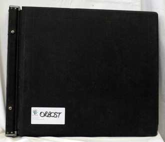
 Orbost & District Historical Society
ledger, POUND KEEPERS BOOK ORBOST COUNCIL, mid 20th century
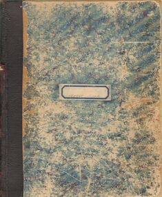
This ledger was used by the Shire of Orbost pound keeper from 15 june 1947 -12 June 1971. The item was donated to Orbost & District Historical society from P.R.O.V. as a Place of Deposit (POD) item for safe keeping by a local history group or museum. The shire covered an area of 9,347 square kilometres and existed from 1892 until 1994 when it became part of the East Gippsland Shire Council. Orbost was at first included in the Bairnsdale Shire from 1882 and was later part of the Tambo Shire. Because of travelling distances the Croajingalong Shire was created in 1892 (name changed to Orbost Shire 17.2.1893 with James Cameron as the first Shire President. In 1994 it amalgamated to become part of East Gippsland Shire Council. This book records the impounding of animals which have been found wandering on local roads or trespassing on land. Many are farm animals. Impounded animals were either claimed by their owners after payment of a fee or if unclaimed , they were sold. The Orbost Pound was situated on Martin Street.This book is a record of a practice which was necessary to remove stock which were wandering on local roads or trespassing on neighbours. It contains many local names and is of social interest. (ref. Vic. Collections)A rectangular hard cover leather bound ledger with fawn cloth spine, titled "POUND KEEPERS BOOK SHIRE OF ORBOST". Inside the back cover are several sales dockets and Shire of Orbost By-Law No 48. Pages are lined in blue and red and pages are headed in black . Entries are hand written in blue and black. The entries give particulars of the animal impounded and where found with name of council officer and owner, if known.orbost-pound orbost-shire-council -
 Orbost & District Historical Society
cash book, 1905 - 1914
This ledger was used by the Shire of Orbost pound keeper from 1906 - 1914. The item was donated to Orbost & District Historical society from P.R.O.V. as a Place of Deposit (POD) item for safe keeping by a local history group or museum. The shire covered an area of 9,347 square kilometres and existed from 1892 until 1994 when it became part of the East Gippsland Shire Council. Orbost was at first included in the Bairnsdale Shire from 1882 and was later part of the Tambo Shire. Because of travelling distances the Croajingalong Shire was created in 1892 (name changed to Orbost Shire 17.2.1893 with James Cameron as the first Shire President. In 1994 it amalgamated to become part of East Gippsland Shire Council. This book records the impounding of animals which have been found wandering on local roads or trespassing on land. Many are farm animals. Impounded animals were either claimed by their owners after payment of a fee or if unclaimed , they were sold. The Orbost Pound was situated on Martin Street.This book is a record of a practice which was necessary to remove stock which were wandering on local roads or trespassing on neighbours. It contains many local names and is of social interest. (ref. Vic. Collections)A ledger with a black cover, brown binding. The page edges are marbled. It contains hand-written records of payments received by the treasurer of the Orbost Pound.on spine : inside a red box in gold lettering"Pound Cash Book" inside a black box in gold lettering"Shire of Orbost"orbost-shire-council orbost-pound accounts cash-book -
 City of Moorabbin Historical Society (Operating the Box Cottage Museum)
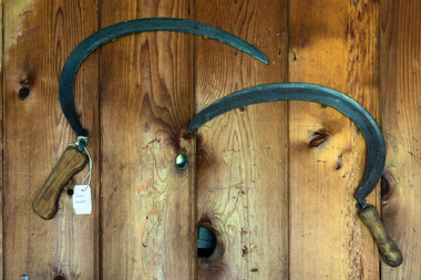
Tools, metal scythe, c1880
A scythe is an agricultural hand tool for mowing grass or reaping crops. It was largely replaced by horse-drawn and then tractor machinery. A scythe consists of a wooden shaft and a long, curved blade is mounted at the lower end, perpendicular. Scythes always have the blade projecting from the left side when in use. Mowing is done by holding the handle , with the arms straight, the blade parallel to the ground and very close to it, and the body twisted to the right. The body is then twisted steadily to the left, moving the scythe blade along its length in a long arc from right to left, ending in front of the mower, thus depositing the cut grass to the left. Mowing proceeds with a steady rhythm, stopping at frequent intervals to sharpen the blade. The correct technique has a slicing action on the grass, cutting a narrow strip with each stroke Mowing grass is easier when it is damp, and so hay-making traditionally began at dawn and often stopped early, the heat of the day being spent raking and carting the hay cut on previous daysEarly settlers and market gardeners used these scythes as they established their farms in Moorabbin Shire c1880A large metal scythe with a wooden handle x 2early settlers, pioneers, market gardeners, moorabbin, bentleigh, brighton, cheltenham, tools, blacksmiths -
 Otway Districts Historical Society
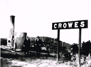
Photograph, Brucker, Crowes after the 1919 fires, 1919
The 1919 bushfire was the worst the area suffered. The fire struck on Saturday afternoon on the 15th February. It destroyed the station at Lavers Hill and Crowes, departmental residences at Lavers Hill and Weeaproinah, the overhead bridges at Beech Forest and Wimba, and damaged the track at various points along the line so that two locomotives became temporarily marooned at Beech Forest.. By the following Tuesday a daily fire relief train had begun operation. By the following Sunday a special train loaded with army tents travelled through to Lavers Hill and deposited most of its consignment there because little remained of this sizeable settlement. An outsider would have had difficulty in picking the place. The letters of the Lavers Hill station nameboard had been burnt although the metal letters survived, and one of the local wags had rearranged them to read "LIARS HELL". By the 1920s water trains were being used to help fight fires, a simple NQR open wagon loaded with the standard 1500 litre square iron water tank.B/W. Crowes station sign, the remains of a chimney, galvanised iron sheet and a water tank, and two men gazing at the camera. Note in the background the clear felling of the timber.crowes; lavers hill; beech forest; weeaproinah; wimba; railways; bushfire; -
 The Beechworth Burke Museum
Geological specimen - Garnet crystals in galena, Unknown
Majority of Galena in Australia is found in hydrothermal deposits emplaced around 1680 million years ago which have been heavily metamorphosed. Galena is the natural mineral form of lead sulfaide. It occurs generally as fine to large crystals due to syntectonic remobilization at low temperatures and moves to a suitable location. The colour is a shining lead and silvery gray with high specific gravity between 7.2 and 7.6 gms/cm3 and contains 86.6 lead sulfaide in its purest form. Its cyrstal system is cubic with perfect cleavages, and contract penetration and lamellar twinning. This particular specimen is from the Broken Hill mine, it is one of the largest lead mines located in Western New South Wales and still has ore reserves amounting to 20.9 million tonnes of ore grading of 7.4% lead, 9.4% zinc, and 61.5 million oz of Silver. Throughout its history, it has produced over 200 million tonnes of ore throughout its 127 years of mining history dating back to 1885. Galena mineral ore found in Australia is considered rare, as it is only currently found in the Broken Hill Mine of Western New South Wales. It represents heritage value through the systematic collecting of the geological surveyers in Victoria and Australia during the early to late 19th Century. The fact that it is only found in one mining area of Australia, shows that this specimen is rare for examples of Australian Galena. This mineral specimen is one part to a larger collection, aquistion, and distribution of Garnet in Galena around Australia and parts of the world and donated to the Burke Museum between 1860-1880. While this specimen was not found by the Victorian Geological Survey, it shows the historical need for mapping geological areas around the Gold Rush region to further identify areas of precious metal and gem aquisition. Additionally, collecting these specimens was an important part of mapping the scientific make up of the earth's surface. Many were sent to institutions for further contribution to research and scientific knowledge of the specimens. A solid coin-sized lead and zinc sulphaide and zinc silicate ore mineral in shades of black and red with shiny black points. GARNET CRYSTALS in / GALENA (lead sulphide), / SPALERITE (zinc sulphide), / WILLEMITE (zinc silicate) ore. / Locality: Broken Hill, NSWburke museum, #beechworth, indigo shire, beechworth museum, geological, geological specimen, mineral, galena, galena quartz, broken hill mine, broken hill, nsw -
 Federation University Historical Collection
Book, Australasian Institute of Mining Engineers, Transactions of the Australasian Institute of Mining Engineers, Volume X, 1905, 1905
Fabric covered hardcovered book of 367 pages. Includes a number of pullout plans. Contents * Mount Lyell Mining Field Tasmania by Professor J.W. Gregory * Concentration of solver-led ores (with 6 plates) by V.F. Stanley Low * Phosphate Deposites of Ocean and Pleasnt Islands (with 15 plates) by F. Danvers Power * Coal and Coal Mining in New SoPleassant Isuth Wales by Thomas Parton * Method of TImbering at the Mount Rex Tin Mne, Ben Lomand, Tasmania by Mark Ireland * Peck's Centrifugal Elevator by W. Peck * A Portable Assay Furnace by J.J. Gillio * NOtes on Sampling by A.C. Thomas * The Career of the Gold Dredge i n New South Wales by David K. Blair * The Transmission of Power by COmpressed Air in Mines by R.W. Chapman * The Misplacement of Mning Shafts and Adits in Victoria (with 7 figures) * The Indicators of the Daylesford Gold Mines, Victoria * Mining Accounts by R.N. Kirknon-fictionausimm, a.s. kenyon, frank a. moss, mount lyell, j.w. gregory, coal, gold dredge, transmission of power, mining shaft audits, daylesford gold mines, spitzkastens, ocean island banaba, pleasant island nauru, pinnacles on flat reef pleasant island, ocean island, blow hole howe bay, rock phosphate, thomas parton, mark ireland, mount rex tin mine, ngapara dredge, w. peck, w.h. vale, daylesford, jim crow diggings, glenmona gmc, f. danvers power, leigh g. hancock, workers' industrial union of australia (barrier district) -
 Ringwood and District Historical Society
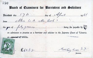
Memorabilia, Winifred McCook, Barrister and Solicitor, Ringwood, Victoria
Miscellaneous papers/ephemera from the office of Miss McCook, the first and only female Solicitor in Ringwood for many years, practicing from her office at 173 Whitehorse Road until her retirement. 5525A. Receipt for payment of £42 (forty guineas) payable on admission to practice as a barrister and solicitor in the Supreme Court of Victorias, dated 17th April, 1946. 5525B. Wages return, financial year ending 30th June, 1954, £1470-8-0. 5525C. Invoice and receipt for dental work Dr to David M. Lush, 145 Whitehorse Road, Ringwood, 15-9-1967, $110. 5525D. Stationery - envelope and letter head from pracice of Winifred McCook, LL.B., Barrister and Solicitor, 173 Whitehorse Road, Ringwood, 3134, Telephones 8708532 8703834. 5525E. State Bank Term Deposit Receipt to Miss Winifred A. McCook, 87 Dorking Road, Box Hill 3128, maturing 15/2/1982, $1400. -
 Bendigo Historical Society Inc.
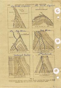
Document - REEFS AND SPURS ON BENDIGO GOLDFIELD
Three pages of information (copied ) regarding reefs and spurs on Bendigo Goldfield. Page 1020 'Geology of Australian ore deposits', drawings labelled in blue biro: No 19 level Virginia Mine, No 6 level South Virginia; No 9 level, Big blue, Big Blue, Deborah Cons'ted ( consolidated?) North Deborah. On bottom ' cross sections through various saddle reefs, showing the range of shape possible, and the association with monchiquite dykes' Page 1021 ( cont) Virginia South Extended; 3000ft New Chum Rly; Catherine Reef, Spurs in Carlisle. On bottom ' Cross sections through a trough reef, 'double' saddle reef and spurry systems. Final page: mines listed and descriptions of workings: Golden Age, Johnson's Reef Extended, Golden Pyke, Constellation, Great Northern, Virginia, Specimen Hill United, New Argus, Clarence United, North Argus, South New Moon.bendigo, mining, reefs and spurs -
 Bendigo Historical Society Inc.
Document - MCCOLL, RANKIN AND STANISTREET COLLECTION: CENTRAL NELL GWYNNE NORTH BLUE CONSOLIDATED
Hardcover blue/cream book, black spine. On sticker on front 'Central Nell Gwynne Consolidated Company Gold Book' First 3 pages held together by paper clip, dated 1922, on top of page, North Blue Consolidated Co. Entries relate to bullion, weight advanced upon , amount of advance, weight after melting, value, balance of assay. . Following pages date commences 1933, July 28 entry 'Coy North shaft, weight advanced upon, amount of advance, weight after melting, fineness (mint and bank charges written in pen ) Eq standard weight, value, balance of assay. Monthly entries continue until March 1942. Blue bank deposit slip dated 13 June 1941, for 1628/8/- for Central Nell Gwynne, equates to entry in bullion book of that date. Inside front cover: slips of paper with handwritten equations.gold, mining, nell gwynne north blue consolidated -
 The Beechworth Burke Museum
Geological specimen - Feldspathic Sandstone
Feldspathic arenites are sandstones that contain less than 90% quartz, and more feldspar than unstable lithic fragments, and minor accessory minerals.Feldspathic sandstones are commonly immature or sub-mature.These sandstones occur in association with cratonic or stable shelf settings. Feldspathic sandstones are derived from granitic-type, primary crystalline, rocks. If the sandstone is dominantly plagioclase, then it is igneous in origin Sandstone features prominently in public buildings throughout Victoria. Most of the sandstone used as dimension stone in the State came from three sources: the Heatherlie quarry in the Grampians (Silurian), the Bacchus Marsh area (Permian), and the Barrabool Hills near Geelong (Cretaceous).Sandstone features prominently in public buildings throughout Victoria, making this specimen special as it shows the materials used by Victorian building companies. Sandstone can also be crushed, crushed stone is used in the construction of roadways and road structures such as bridges, and in buildings, both commercial and residential. This specimen is part of a larger collection of geological and mineral specimens collected from around Australia (and some parts of the world) and donated to the Burke Museum between 1868-1880. A large percentage of these specimens were collected in Victoria as part of the Geological Survey of Victoria that begun in 1852 (in response to the Gold Rush) to study and map the geology of Victoria. Collecting geological specimens was an important part of mapping and understanding the scientific makeup of the earth. Many of these specimens were sent to research and collecting organisations across Australia, including the Burke Museum, to educate and encourage further study. A feldspar-rich sandstone, a sandstone intermediate in composition between an arkosic sandstone and a quartz sandstone, containing 10% to 25% feldspar and less than 20% matrix material of clay, sericite, and chlorite. Feldspathic arenite containing less than 90 percent of the composition of quartz. Feldspar is the main composition. Feldspathic arenite may contain fragments of unstable rock, and a little amount of other minerals such as mica and heavy minerals. Some feldspathic arenite have pink or red color because of the presence of potassium feldspar or iron oxide. There are also colored light gray to white. These sandstones are usually medium to coarse grained and can contain a high percentage of granules with angular until subangular roundness. The content of the matrix can appear as the rest up to more than 15 percent, and sorting of grains can present as moderate to poorly sorted. Feldspathic sandstones are generally immature in textural maturity. Feldspathic arenite can not be judged from the structure of the sediment. Bedding can emerge from the laminate parallel to the crossbed. Fossils may appear in the layer deposited on the sea. Feldspathic arenites usually appear on the craton or the continental shelf, which can be associated with conglomerate, quartz lithic arenite, carbonate rock, or evaporites. This sandstone may also appear on the succession of sedimentary basins deposited on an unstable or deep sea, and moving arc setting. According to Pettijohn (1963) Arkose make up about 15 percent of all sandstones. Some Arkose formed in situ when the granite and related rocks disintegrate and generate granular sediments. Most of the material feldspathic sandstones derived from primary crystalline granitic rocks, such as granite or metasomatic rocks containing abundant potassium feldspar. Mineral contained in sandstones is mostly a form of plagioclase feldspar derived from quartz diorite or volcanic rock. Feldspar contained on this sandstone comes from arid to cool climates when the chemical weathering process is reduced.sandstone, natural stone, feldspathic sandstone, burke museum, geology, geological, geological specimen -
 Ringwood and District Historical Society
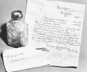
Photograph, Photo and report of letter found in a bottle at "Merrigan", home of William MacKinlay ,Ringwood North, 1917
Black and white photographs and newspaper cutting. (Images P0133a and P0133b)Image P0133a reads: " 'Merrigang', Ringwood North, 1917. This paper, enclosed in a bottle, was..... by William and Eliza Mackinlay of Ringwood, Victoria. William Mackinlay was born at Campbellfield, Victoria on the 19th February 18?? A.D.. Elizabeth Mackinlay, nee White was born at Richmond, Victoria on the 28th May 1856. The house in which this is deposited was built by the above named, as a dwelling for their son William Raney Mackinlay and his wife Amy Justin, daughter of ?? Somerville. (Signed) William Mackinlay, Elizabeth Mackinlay." The other small note reads- "To the finder- look within" Image P0133b is of Raney Peake. Newspaper cutting is from the Mail 10-2-66. -
 National Wool Museum
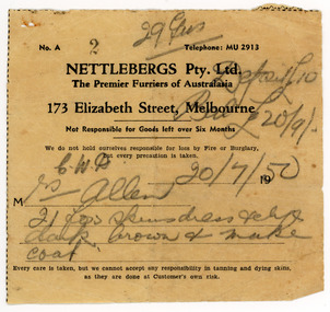
Document - Receipt, Fox Fur Coat, Nettlebergs Pty Ltd, Nettlebergs Pty. Ltd, 20/7/1950
This receipt is for a fox fur coat made in Melbourne in 1950 by Nettlebergs. It is associated with the fox fur coat in the National Wool Museum Collection, NWM-9090. "The foxes were shot in the 1950's by my Father, Charles Winnet Daniel Allen at two properties around Bacchus Marsh. One was Greystones at Glenmore, owned by the O'Keith family and the other was at Parwan, owned by the Miles Family. In the late 1940's and early 1950's, the Government put a bounty on the fox head. A pair of ears were sent to the Council and you were paid 2 pennies and the skins were sold to a skin buyer. My Father would go out on moon lit nights and shoot the foxes then skin them, which he would peg on a board to dry. He took 21 fox skins to Nettlebergs Pty. Ltd., Furriers at 173 Elizabeth Street Melbourne, Victoria, to have this coat made for my Mother, Gladys Eileen Allen. It cost Twenty Pound and Nine Shillings to have the skins made into this coat. My Father died on the 1st July 1982 and my Mother on the 15th October 1993, aged 76. This coat was inherited by me Theresa Joy Hodge (nee Allen) on the passing of my Mother. I have worn it on cold days, but seeing that I am 84 and the coat is 74 years old, I would like to donate it to you, as I have no-one to leave it to and hope that you and the visitors to your Museum will enjoy looking at it." Theresa Hodge, 2025 Theresa was a dairy farmer, who grew up in Bacchus Marsh with her parents, before moving to South Australia in 1980 to a 167 acre farm in Burrungale.Single sided paper receipt with black printed text and handwritten text in pencil.front: [printed] No. A / 2 / Telephone: MU 2913 / NETTLEBERGS Pty. Ltd. / The Premier Furriers of Australasia / 173 Elizabeth Street, Melbourne / Not Responsible for Goods left over Six Months / We do not hold ourselves responsible for loss by Fire or Burglary, / but every precaution is taken. / 19 / M / Every care is taken, but we cannot accept any responsibility in tanning and dying skins, / as they are done at Customer's own risk. front: [handwritten] 29 ? / Deposit £10 / Bal £20/9 / C. W. A. 20/7/50 / Mrs Allen / 21 fox skins dress pelts / dark brown + make / coatfox fur coat, fashion, hunting, pest eradication, farming, rural life, bacchus marsh, greystones, glenmore, parwan, fox, nettlebergs pty ltd, furriers, clothing, theresa hodge, charles allen, gladys allen -
 The Beechworth Burke Museum
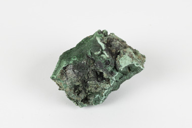
Geological specimen - Malachite, Unknown
Malachite is a copper carbonate hydroxide mineral. It has a chemical composition of Cu2(CO3)(OH)2. It often forms within limestone where a subsurface chemical environment favourable for the formation of carbonate minerals can occur. It is a substance that can be found in many different parts of the world including: Australia, USA, Russia and the Democratic Republic of Congo. Malachite has historically been used to produce copper, with mining of the mineral dating back over a period of four thousand years. Due to its beautiful green colourations, it is also commonly used for aesthetic purposes such as in the production of sculptures and jewellery. This particular specimen was collected from the town of Burra, South Australia as part of a geological survey undertaken during the nineteenth century. The locality (located on Ngadjuri Country) has a long history of mining, particularly in copper mining, as the area is rich in copper deposits. The first significant discovery of this was made in Burra (Burra Burra Mine) in 1845 and, at the time, the mine was the largest and richest of its kind in the world, producing nearly five percent of the total world copper output. This specimen is significant as it is considered to be a rare gemstone, as many of the original deposits for the stones are significantly depleted, leaving behind very few sources. This specimen is part of a larger collection of geological and mineral specimens collected from around Australia (and some parts of the world) and donated to the Burke Museum between 1868-1880. A large percentage of these specimens were collected in Victoria as part of the Geological Survey of Victoria that begun in 1852 (in response to the Gold Rush) to study and map the geology of Victoria. Collecting geological specimens was an important part of mapping and understanding the scientific makeup of the earth. Many of these specimens were sent to research and collecting organisations across Australia, including the Burke Museum, to educate and encourage further study.A solid palm-sized copper carbonate hydroxide mineral with patterns of green colourations Existing Label: MALACHITE / Locality: Burra / S. Aust. Other Label: Confirmed / as Malachite / C. Willman / 15/4/1 / + Bill Birch burke museum, beechworth, geological, geological specimen, malachite, gemstone, green gemstone, burra, burra burra mine, burra south australia, carbonate mineral, copper, copper mining, copper mining burra, carbonate hydroxide mineral, copper carbonate, malachite mining, malachite burra, monster mine -
 Orbost & District Historical Society
ledger, late 1950's - 1970's
This ledger was used by the Shire of Orbost in the late 1950's - 1970's.The item was donated to Orbost & District Historical society from P.R.O.V. as a Place of Deposit (POD) item for safe keeping by a local history group or museum. The shire covered an area of 9,347 square kilometres and existed from 1892 until 1994 when it became part of the East Gippsland Shire Council. Orbost was at first included in the Bairnsdale Shire from 1882 and was later part of the Tambo Shire. Because of travelling distances the Croajingalong Shire was created in 1892 (name changed to Orbost Shire 17.2.1893 with James Cameron as the first Shire President. In 1994 it amalgamated to become part of East Gippsland Shire Council. The Country Roads Board was the government authority for the construction and maintenance of main roads in Victoria between 1913 and 1983. It was succeeded by the Road Construction authority on 1 July 1983 and later merged with the Road Traffic Authority on July 1 1989 to form the Roads Corporation. James Cameron, an Orbost farming pioneer and Member of the Legislative Assembly, fathered the Country Roads Board This item is a hand-written record of Orbost Shire Council accounts. It pre- dates computer records. The Shire of Orbost local council no longer exists having been absorbed by the East Gippsland Shire Council.A black ledger with wooden covers. It contains hand-written records of transactions between Orbost Shire Council and the Country Roads Board.bottom left corner - Orbost in black on a white East Gippsland Shire logoledger accounts shire-of-orbost country-roads-board -
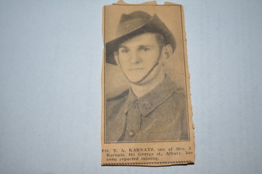 Wangaratta RSL Sub Branch
Memorabilia - Assorted Papers
Brown vinyl wallet containing various papers including identity card, receipt for 60 pounds deposit for 1929 Dodge dated 23/12/1947, Ministry of Food vouchers, postcard, newspaper cutting, black and white photograph of two young boys with a bicycle - handwritten on rear from Mrs T A Karnatz Tawonga Roadside Wodonga Victoria Australia to Private Thomas Karnatz Prisoner of War No 139745 ARB KDO 7001 Stalag 11B Germany. Item belonged to Thomas Allan Karnatz VX 48290 2/24 Battalion - born 16/7/1916. Enlisted Albury 22/7/1940 - Caulfield 8/8/1940 aged 24 years 17/10/1940 posted from 2/23 to 2/24 Battalion. Embarked 16/11/1940 and disembarked Middle East 17/12/1940. Reported missing in action on 6/5/1941 and officially prisoner of war on 8/7/1941. 26/4/1945 arrived UK recovered POWBrown vinyl wallet containing assorted military and personal papersInside printed in gold lettering - Good wishes from the Australian Red Cross Societyww2, pow, 2/24 battalion, t a karnatz, tobruk -
 Melbourne Legacy
Photograph - Photo, Legatee function, 1991
Photos of the launch of Legacy Week in 1991. The guest speaker was Sir Zelman Cowan, a former Governor General of Australia. The launch was in the Crest International Hotel in St Kilda on 3 September 1991. Sir Zelman spoke movingly on the work of Legacy and on the dramatic world events: the Gulf War; the reunification of Germany; the changes within the Soviet Union and his speech was warmly received by all who attended. The speaker and head table are under the Legacy Banner - which says "Legacy Caring for Australia's Biggest Family". The same banner is used at an event in Melbourne City Square - see 000491 (from the same roll of film). President John Sullivan is on the head table and is also in a photo at the Eternal Flame (000493 from the same roll of film). Part of a Legacy Appeal or Badge week launch in 1991. Seems to have fallen of a scrapbook of photos compiled by Legacy of major events in the 1980s and 1990s and deposited in the archive cabinets along with many other items and photos prior to the start of the cataloguing. See other photos at 01581.A record of a Legatee event to launch Legacy Week in 1991.Colour photo of the launch of Legacy Week 1991 at the Crest International.legacy appeal, legatee event, badge appeal -
 The Beechworth Burke Museum
Photograph - Photograph - Reproduction, W. D. Gibbon, Early 1900s
This photograph was taken in 1911 at Three Mile Creek, about five kilometers south of Beechworth town. Significant digging took place at this location from late 1855, which led to a flood of workers and stores to follow, though daily earnings were slim compared to the nearby Woolshed site. This remained the case even after workers at Three Mile Creek attempted to protest around Beechworth during an election in November 1855. Three Mile Creek was one of seven significant divisions of the Beechworth Mining District formalised by the Governor-in-Council in 1858, though by the time this photograph was taken, the boundaries of the original seven districts had shifted to create seventeen divisions. The Three Mile Goldfields was a site of rich alluvial gold deposits located about 5km south of Beechworth in Victoria. Today, the location of this gold deposit is called Baarmutha. It was a popular area for gold mining in the 1850s but became largely abandoned by the following decade. In 1865, a man named John Pund (a man second from the left in the back row of this photograph shares this surname) recognized that the area could be potentially rich if a better water supply could be obtained. He secured a 15 year license with three other miners. Within the next five years, these men had constructed 19 km of water race going from Upper Nine Mile Creek to Three Mile Creek. By 1881, these four men had delivered 950,000 gallons to the Three Mile Sluicing area which is depicted in this photograph. Pund would later go into partnership with John Alston Wallace who would become owner of the Star Hotel in Beechworth. The Three Mile sluicing location continued to be operational until 1950. The eleven miners in this photograph are: Back row: Led Guthrie, P. Pund, F. Beel, [Unknown] Miller Front row: Paddy McNamara, J. King, W. Beel, [Unknown] Garland, J. Clarke, J. Ryan, H. Bartsh In the background of the photograph is a huge dirt wall that appears to suffer damage caused by hydraulic sluicing. Hydraulic sluicing is a specialised mining technique that involves directing high pressure water flows at dirt to uncover gold. The technique played a significant role in shaping Beechworth's landscape during the gold rush to create the topography seen today.The search for gold is ingrained into the history of Victoria and therefore, images like this one which portray an open cut sluicing site can reveal important information for society and technology for the date when the photograph was taken. This image is of important historical significance for its ability to convey information about sluicing and the methods used to find gold in the late 1800s and early 1900s. It also shows a location where sluicing was undertook which provides insight into the impact of sluicing on the environment at a time when it was done. Images, like this one, of Australian gold rush history can reveal important information about the social and environmental impact of this period. This image depicts diggers standing in a mining location and therefore, this image has the capacity to reveal or support significant information for researchers studying the fashion and social status of diggers in Australia in approximately 1911. It can also provide information on the landscape of Australia in this period and the impact of mining for gold on both society and the Australian landscape. The Burke Museum is home to a substantial collection of Australian mining photographs which can be used to gain a deeper understanding into life on the gold fields, technology used in mining, the miners themselves and the impact of the gold digging on the environment.Black and white / sepia rectangular reproduced photograph printed on glossy photographic paper mounted on board.beechworth, beechworth museum, mining, mining team, three mile creek, sluicing, hydraulic sluicing, photography, gold sluicing, gold mining, pund mining -
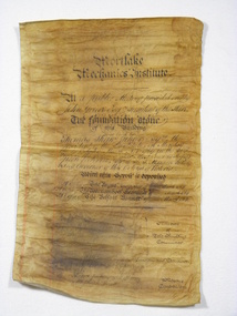 Mortlake and District Historical Society
Document, Mortlake Mechanics' Institute Scroll
In April 1869 when the foundation stone of the Mortlake Mechanics' Institute was laid by Thomas Shaw of Wooriwyrite, this parchment scroll was sealed with other documents in the foundation stone. In 1891 when further alterations were made the hall these documents were retrieved from the stone. This building was erected to house the local library whichup until that time had been housed in the Morllake Common School.Discoloured foolscap parchment with copperplate lettering, some water damage which has caused the obliteration of the names of the Members of the Building Committee, Hon.Secretary and Architect. At a Public Meeting presided over by John Grieve Esq. President of the Shire/The foundation stone/of this building/was laid by - /Thomas Shaw Junior Esquire the President of the Institute on Monday/the 29th day of March A. D. 1869 in the 32nd year of the Reign of Her/Most Gracious Majesty Queen Victoria Sir I. A. T. Manners Sutton/being Governor of this Colony of Victoria/With this Scroll is Deposited/A copy of The Argus Newspaper of 28th March 1869/A copy of The Warrnambool Examiner of ? March 1869/A copy of The Belfast Examiner of 17th March 1869/Members of/The Building/ Committee/Hon.Secretary and Treasurer/Architect/Contractors/Messrs Jenkins and Harvey,Mason/Mr Joseph Wyatt,Carpenter.institute, free, libraries, public buildings, mortlake, mechanics -
 Federation University Historical Collection
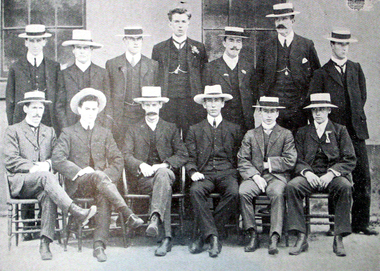
Book, Ballarat School of Mines Students' Magazine, 1902-1906, 1902-1906
The Ballarat School of Mines is a predecessor institution of Federation University Ausgtralia.Five copies of the Ballarat School of Mines Students' Magazine bound in a blue hard cover and quart bound in calf. 1902 - Retirement of Herbert L. Krause 1905 - Mt Lyall Ore Deposits Images: Ballarat School of Mines Sports Association Committee and Officers, 1905 Standing left to right: W. Pearce, T. Williams, S. Hepburn, Seward, W. Figgis, J.R. Reid, P. Elliott Sitting left to right: P.A. Pratt, N. Buley, John Sutherland, H.R Murphy, J. Inglis, R. Nevett 1906 Excursion to Broken Hill, The Artistic Printing Process, Hints on Portraiture, Arizona, Cornish Mining Images Ballarat School of Mines and AusImm at the Central Mine, Broken Hill; At Iron Knob, Brown Boveri Turbo Generator at Block 10, Junction Mine plant or Potter Process, Broken Hill Propriety Mill, Carlyon's Hotel, Sam Jamieson, Electrical Labortory, Ballarat School of Mines Rowing Eight, Sports Committee,ballarat school of mines, magazines, sports committee, thomas williams, mount lyell, w. pearce, t. williams, s. hepburn, seward, w. figgis, j.r. reid, p. elliott, p.a. pratt, n. buley, john sutherland, h.r murphy, j. inglis, r. nevett, herbert l. krause, broken hill, artistic printing process, hints on portraiture, arizona, cornish mining, ausimm at the central mine, broken hill, iron knob, brown boveri turbo generator at block 10, junction mine plant or potter process, broken hill propriety mill, carlyon's hotel, sam jamieson, electrical labortory, ballarat school of mines rowing eight, sports committee,, rowing on lake wendouree, boat shed, h. valentine, l. seward, c. macgennis, d. don, m. gaunt, h. owne, l. nott, s. leathes, j.a. reid, h.r. murphy, alfred mica smith, r. hosking, zeehan, moonta, wallaroo, smelting silver, south africa, south australia excursion, sunnyside woollen mills, tasmanian excursion, swedish iron, mt jukes excurson, western australian gold ore, wynne-grant furnace, bhp sintering slimes, leggo furnace, mine ventilation, mount morgan mine, mount pani ltd, new zealand coal, adelaide school of mines, students' association, at iron knob, ausimm, excursions, visits, south australian excursion -
Bendigo Historical Society Inc.
Map - GEOLOGICAL MAP: BENDIGO GOLD FIELDS
GEOLOGICAL MAP - BENDIGO GOLD FIELDS - Donated by JOHN HORWOOD. Two geological maps of the Bendigo Gold fields. The maps display , reef lines, Hills, Dams and mine locations. Also Anticlines, sinclines, shafts, alluvial deposits, contours and gullys. All items are superimposed on a map of the major roads and streets of Bendigo. The maps were printed by The Victorian Minister for Mines in 1923 and re-issued in 1936. The maps have been specifically framed and donated to The Bendigo Historical Society Inc. in May 2015 for display at Specimen Cottage. John had been a student at The School of Mines- Bendigo and found them useful as a student living in Bendigo. Prior to being framed , the maps have been kept rolled up in his home. Accession Number 309/15 Were on Display at Specimen Cottage 2015 - 2020. After all items removed from SC to the BRAC in 2021 the framed maps could not be located. Search ongoing. BP 2.3.2023Victorian Minister of Minesgoldfields -
 Bendigo Historical Society Inc.
Administrative record - South Frederick the Great Gold Mining Company N.L. Gold Book, 1934 - 1917
Patterned hard cover, black binding on spine.Written across top of first page: South Frederick the Great GM Coy N.L. Inside pages a double spread recording the 'Gold Purchased by Bank; weight advanced upon, amount of advance, weight after melting, mint and bank charges, eq standard weight, value and balance of assay. Dates from August 1934 to December 193k7. Inserted in pages of gold book: a. receipts " Commercial Banking Company of Sydney (Bendigo) recording the particulars of gold melted and assayed on account of South Frederick the Great Co. N.L. and slips from Royal Mint, Melbourne Branch, showing out turn of deposits left for coinage. Weight before and after melting, assay reports of gold and assay report of silver and standard gold oz., total value assessed. b. Letter May 13th, 1935 from Herbert L. Archbold, enclosing cheque for 9/5/- for described weight: 11 tons, 18 cwt, 3 q. bendigo, margaret roberts, south frederick the great gold mining co. n.l., sebastian, mccoll, rankin and stanistreet -
 The Beechworth Burke Museum
Geological specimen - Malachite, Unknown
Malachite is typically found as crystalline aggregates or crusts, often banded in appearance, like agates. It is also often found as botryoidal clusters of radiating crystals, and as mammillary aggregates as well. Single crystals and clusters of distinguishable crystals are uncommon, but when found they are typically acicular to prismatic. It is also frequently found as a pseudomorph after Azurite crystals, which are generally more tabular in shape. This particular specimen was recovered from the Burra Burra Copper Mine in Burra, South Australia. Otherwise known as the 'Monster Mine', the Burra Burra Copper Mine was first established in 1848 upon the discovery of copper deposits in 1845. Within a few short years, people from around the world migrated to Burra to lay their claim in the copper economy. By April 1848 the mine was employing over 567 people and supporting a population of 1,500 in the local township. Up until 1860, the mine was the largest metals mine in Australia, producing approximately 50,000 tonnes of copper between 1845 to its closure in 1877. The Burra Burra Mine was also famous for a number of other specimens, including; crystalline azurite, cuprite, and botryoidal and malachite. Malachite is considered a rare gemstone in that the original deposits for the stones have been depleted leaving behind very few sources. In addition, the use of Malachite as gemstones and sculptural materials remains just as popular today as they were throughout history. It is quite common to cut the stone into beads for jewellery. The fact that Malachite has such a rich colour and one that does not fade with time or when exposed to light makes it particularly rare. This specimen is part of a larger collection of geological and mineral specimens collected from around Australia (and some parts of the world) and donated to the Burke Museum between 1868-1880. A large percentage of these specimens were collected in Victoria as part of the Geological Survey of Victoria that begun in 1852 (in response to the Gold Rush) to study and map the geology of Victoria. Collecting geological specimens was an important part of mapping and understanding the scientific makeup of the earth. Many of these specimens were sent to research and collecting organisations across Australia, including the Burke Museum, to educate and encourage further study. A solid hand-sized copper carbonate hydroxide mineral with shades of blue and light green throughout. burke museum, beechworth, indigo shire, beechworth museum, geological, geological specimen, mineralogy, burra, burra burra mine, south australia, malachite, malachite specimen -
 The Beechworth Burke Museum
Geological specimen - Bituminous Coal, Unknown
Bituminous coal is the most common type of coal, abundantly found in ancient coal deposits which can be dated back millions of years. Often referred to as soft or black coal, this specimen exhibits a high carbon content, ranging from 76-86%. It also holds a relatively high energy density (27 MJ/kg) meaning that it releases significant amounts of energy when burned. Bituminous coal is most commonly used for electricity generation, as well as in the production of steel. This particular piece of coal was collected as part of the Geological Survey of Victoria in the nineteenth century. It originates from Cape Paterson, a seaside village located in South Gippsland, Victoria (located on Bunurong Country). The discovery of bituminous coal in this locality was first made in 1826 by explorer William Hovell. More discoveries were gradually made over the following decades and in 1859 the Victorian Coal Company commenced the first active coal mining operations in the state by sinking a number of shafts and bores near the area of Cape Paterson. Evidence of this coal-focused past can be found today at the State Coal Mine Museum in the nearby town of Wonthaggi. This specimen is significant as it was collected from the locality of Cape Paterson in Victoria, an area that has since become historically instrumental in the mining of coal and other substances in the state of Victoria. This specimen is part of a larger collection of geological and mineral specimens collected from around Australia (and some parts of the world) and donated to the Burke Museum between 1868-1880. A large percentage of these specimens were collected in Victoria as part of the Geological Survey of Victoria that begun in 1852 (in response to the Gold Rush) to study and map the geology of Victoria. Collecting geological specimens was an important part of mapping and understanding the scientific makeup of the earth. Many of these specimens were sent to research and collecting organisations across Australia, including the Burke Museum, to educate and encourage further study. A solid hand-sized piece of bituminous coal with a shiny black-grey surface and jagged edges.Existing Label: BITUMINOUS COAL / Locality: Cape / Patterson, VIC. burke museum, beechworth, geological, geological specimen, state coal mine museum, wonthaggi coal mine, victorian coal company, bituminous coal, coal victoria, coal energy generation, william hovell, cape paterson, coal specimen -
 Eltham District Historical Society Inc
Photograph, Peter Pidgeon, White Cloud Cottage, 701 Main Road, Eltham, 2 Aug. 2022
Jarrold Cottage built c.1853, also known as 'White Cloud", located at 701 Main Road, Eltham, opposite Dalton Street. The house remains intact and is listed on the Victorian Heritage Database and considered historically significant to the Shire of Nillumbik. The cottage was originally located closer to the Diamond Creek but was subject to flooding. It was dragged by horse to the present site shown, which was chosen for the higher ground that had been created as a result of land fill being deposited here from the quarry further around the bend on Main Road (site of present-day Eltham Primary School carpark) where the stone had been quarried for building the State School in Dalton Street. It had previously been rented for use as a Police Station / residence prior to the building of the permanent police house and station at the corner of Maria and Brougham streets in 1859. The cottage was purchased by Lena Skipper after the death of Thekla Jarrold in 1943 and remains in the family to present day (2022). Part of a presentation by Peter Pidgeon to the Society, 13 August 2022 showcasing a series of photographs taken by John Henry Clark over the period 1895 to 1930.Born Digitaleltham, dalton street, main road, bootmaker's shop, jarrold cottage, white cloud cottage -
 Kiewa Valley Historical Society
Drill Bit Diamond, circa mid to late 1900's
This hollow core bit has hard cutting inserts for drilling into rock. It was used to drill and recover 50mm diameter (most common size) rock cores. The rock cores were assessed by geologists and engineers to provide information for design of structures such as tunnels, dams and underground power stations (eg. McKay Creek Power Station, West Kiewa Power Station). This type of bit was also used where damage to the surrounding rock had to be minimised. The Diamond Drill Bit,used in the early 1900's, when it was primarily used as a method of sampling rock for ore deposits and oil exploration resulting in a "coring" of rock. The use of "coring" to obtained samples for the SEC Kiewa Hydro Electricity Scheme(1920's onward) was to analyse the core to obtain temperature and rainfall patterns shown by the levels of layered solidified soil(rock). This diamond drill would have been used in the early 1900's to provide a sub strata map of temperature and water patterns (over an long period of time). This was a pre requisite to any decisions about the viability of the region to provide the water needed for a successful hydro electricity scheme.This diamond drill for core sampling was at the forefront of the analysis whether to construct a hydro electrical facility in the Kiewa Valley and the adjoining alpine region. The rock core samples produced were assessed by geologists and structural engineers. It was only after extensive core drilling covering the region that solid scientific evidence could be provided to start the "SEC Vic Hydro Electricity Scheme" within its current boundaries.This "diamond" drill bit has eight "teeth" at its cutting edge. The drill creates an 55mm hole in extremely hard rock material to obtain 50mm core samples.. Three quarters down the shank it has thread screw channels to attach the bit to the drill pipe. The coring pipe attaches via screwing it onto this bit. Core samples are the main objective of this tool.alternate energy supplies, alpine feasibility studies temperature, rainfall, sec, kiewa hydro electric scheme, electricity