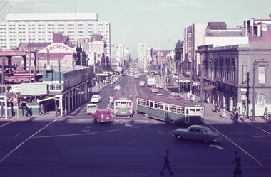
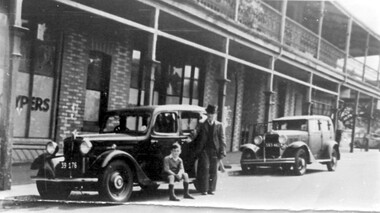
Showing 8616 items matching "house building"
-
 Warrnambool and District Historical Society Inc.
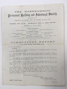
Balance Sheet, Warrnambool Permanent Building and Investment Society 1872, 1872
... to be borrowed to use in the building of houses. A considerable number... to use in the building of houses. A considerable number of houses ...The Warrnambool permanent Building and Investment Society was established in May 1869. It relied on investors buying shares in the society, thereby providing the funds which were available to be borrowed to use in the building of houses. A considerable number of houses in Warrnambool would have been built using this scheme. The stated trustees in 1872 were Samuel Macgregor, C A Cramer, James Astley Bromfield, and the committee comprised of James Hider, W. W. Jamieson, James Coulstock, Archibald MacFarlane, Robert Newton, David Evans, NT C Stelling and W Jones. The bankers were the national Bank of Australasia. It had some difficulties in the 1870’s but was still operating well into the 1930’s where it again was not putting through the volume of business compatible with its resources and it had been found necessary to pay off a considerable number of fixed deposits and Investors’ shares. There is little mention of it after the mid 1930’s. This document provides details of an organization which operated in Warrnambool for over 60 years and proved beneficial to homebuilders and investors alike. It also has a number of well- known local names listed in their positions of operating the building society.Cream watermarked paper folded to four pages. Title on front cover with letter to shareholders printed below for the year ending 30th April 1872. Page three has balance sheet of the Warrnambool Permanent Building & investment Society. Second and fourth pages are blank. Signed in print by James Hider President, Henry T Read secretary.warrnambool permanent building and investment society, warrnambool, warrnambool 1872, -
 Warrnambool and District Historical Society Inc.
Sign - Public Works Office
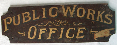
... no longer used as a court house is a building of significance... no longer used as a court house is a building of significance ...This sign points has two different messages. The first states Public Works Office, which was operational in Victoria between 1855 and 1987 dealt with many aspects of the states infrastructure. It had many different reponsibilities and roles from building government accommodation and fit out of buildings, licences for unused roads and water ways, main roads and bridges, ports and harbour,and water supplies. Much of this work was managed through local offices such as the one at Warrnambool. The sign on the reverse which states Witnesses Waiting Room relates to the court house which is where this sign originated.The Warrnambool court house was built in 1870-71 by the Victorian Public Works department and it is possible that this sign relates to that period.It is one of a number of public buildings built in the period 1870-1890 including the Police station and stables and police quarters, the Post Office and drill Hall , all in the same vicinity. This building reflects the growth of the town and also the importance it held at the time from a state level. The building while no longer used as a court house is a building of significance to Warrnambool as well as to the state of Victoria, being one of six around the state which were built in free classical style. This sign denotes the waiting room for witnesses which was situated on the western side of the building.A tangible link which provides historical and social significance to Warrnambool.Rectangular wooden sign with rounded corners. There is text on both sides painted in gold paint with shadow in black. One side is a darker brown stain . There are screw holes in each corner.and one hole on left middle of sign. Rounded edge on one side.Side 1:Witnesses Waiting Room Side 2:Public Works Office.warrnambool, warrnambool court house, public works department warrnambool -
 Eltham District Historical Society Inc
Photograph, Liz Pidgeon, Heritage Excursion; The 1901 Eltham Railway Walk, 3 May 2014, 3 May 2014
... alignment and for some distance each side. The plans show houses... alignment and for some distance each side. The plans show houses ...Football match at Eltham Central Park between Eltham and Heidelberg Newsletter No. 216, May 2014 May Excursion – The 1901 Eltham Railway Walk The railway from Heidelberg to Eltham was opened in 1902. Over the previous year railway construction cut a curving swathe through Josiah Holloway’s 1851 Little Eltham subdivision. The survey plans for the railway show the owners and occupiers of land within Little Eltham affected by the railway alignment and for some distance each side. The plans show houses and other buildings but development at that time was rather sparse. Copies of these plans from the State Library of Victoria collection have been provided to the Society by Alan Sheehan. For our walk on 3rd May we intend to follow the railway from the Eltham Station to Ryans Road, which was the boundary of the adjoining Montmorency Farm. The return will be by way of nearby streets. Along the way we will discuss the details shown on the railway plans as well as more recent railway documents and photographs. At the conclusion and if time permits we can inspect the historical display at the Eltham Station. The walk is about 3 km in length and will take about 2.5 hours. It will start at 2 pm at the Eltham Railway Station car park (east/Main Road side) (Melway Ref. 21 J5).Born Digitalheritage excursion, activities, eltham district historical society, eltham railway station, eltham library, trestle bridge, eltham central park, football -
 Eltham District Historical Society Inc
Photograph, Liz Pidgeon, Heritage Excursion; The 1901 Eltham Railway Walk, 3 May 2014, 3 May 2014
... alignment and for some distance each side. The plans show houses... alignment and for some distance each side. The plans show houses ...EDHS Member Doug Orford stands by a yarn bombing installation. ewsletter No. 216, May 2014 May Excursion – The 1901 Eltham Railway Walk The railway from Heidelberg to Eltham was opened in 1902. Over the previous year railway construction cut a curving swathe through Josiah Holloway’s 1851 Little Eltham subdivision. The survey plans for the railway show the owners and occupiers of land within Little Eltham affected by the railway alignment and for some distance each side. The plans show houses and other buildings but development at that time was rather sparse. Copies of these plans from the State Library of Victoria collection have been provided to the Society by Alan Sheehan. For our walk on 3rd May we intend to follow the railway from the Eltham Station to Ryans Road, which was the boundary of the adjoining Montmorency Farm. The return will be by way of nearby streets. Along the way we will discuss the details shown on the railway plans as well as more recent railway documents and photographs. At the conclusion and if time permits we can inspect the historical display at the Eltham Station. The walk is about 3 km in length and will take about 2.5 hours. It will start at 2 pm at the Eltham Railway Station car park (east/Main Road side) (Melway Ref. 21 J5).Born Digitalheritage excursion, activities, eltham district historical society, eltham railway station, eltham library, trestle bridge, yarn bombing, doug orford -
 Melbourne Water
Photograph, North Cocoroc State Primary School, 1950s
... most of the houses and other buildings were demolished or moved... most of the houses and other buildings were demolished or moved ...As the Yarra became unsuitable as a source of water, several attempts were made to find alternative sources for the growing population of Melbourne. It was not until 1891 that the efforts to sewer Melbourne came to fruition with the setting up of the Melbourne Metropolitan Board of Works (MMBW), now known as Melbourne Water. From 1891 until 1992, it was the responsibility of the MMBW to safeguard public health by providing a sewerage system and a safe water supply system. In 1992, The MMBW merged with a number of smaller urban water authorities to form Melbourne Water. The township of Cocoroc was created in 1894 at the Metropolitan Sewage Farm (now the Western Treatment Plant) to house the workers it employed. The name 'Cocoroc' means 'frog' in the language of the Wathaurung people — the Traditional Owners of the land the treatment plant was built on. By the early 1950s there were nearly 100 houses, a town hall, football ground (and team), swimming pool, tennis courts, four schools and a post office, and by the 1970s some 500 people were living in Cocoroc. As it became too expensive for the MMBW to subsidise, Cocoroc was abandoned. By 1973 most of the houses and other buildings were demolished or moved to Werribee. All that is left now of Cocoroc are two small, empty, concrete swimming pools, a few weatherboard sheds and a big iron water tank. This photograph detailing an exterior view of the North Cocoroc State Primary School, is historically significant as it captures children at play within a purpose built community. The School that was one of four was built to educate the children of the MMBW workers. As the school no longer exists, this photograph is the only tangible evidence left of the building, also showcasing the style of buildings in this era. cocoroc, township, school, mmbw, melbourne metropolitan board of works, melbourne water -
 Linton and District Historical Society Inc
Postcard, A View at Linton, Sussex Street, Linton, view to south, circa 1940
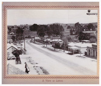
... to it, and the first Bank of NSW building. Two houses are further down the road... McCorkell. Sussex Street Linton Buildings Shops Houses Sandow shop ...The "Lorna, Bob and Elsie" in the inscription are probably Elsie McCorkell, her son Robert Hayward, and her daughter Lorna McCorkell.A very small photograph which has been made into a souvenir/postcard. The photograph is a view of Sussex Street, Linton, looking south-west. On the right of the photo are Ching's store, R. N. Sandow confectionery shop, a house next to it, and the first Bank of NSW building. Two houses are further down the road past Gillespie Street. On the left of the photo are the Edinburgh Bakery and a store with a verandah on the corner of Gillespie Street. The photograph is glued to a beige-coloured card which has a decorative edge cut into it. A printed border surrounds the photograph, and the words "A View at Linton" are printed underneath it. The card appears to have had the right-hand edge trimmed with scissors. Because of this, an inscription on the back of the card has been partially cut away. The inscription reads "-rs Whitehand & Doris / -with love from Lorna, Bob and Elsie".sussex street linton, buildings, shops, houses, sandow shop, ching's store, edinburgh bakery, postcards, souvenirs, lorna mccorkell, robert hayward, elsie mccorkell -
 Melbourne Tram Museum
Slide - Set of 7, Keith Caldwell, 22/03/1969 12:00:00 AM
... with the Windsor Fire Station and the former cable tram winding house... with the Windsor Fire Station and the former cable tram winding house ...Set of seven Agfa colour slide, blue and white plastic mount, photo by Keith Caldwell on 22/3/1969 of the then new track work in Queensway St Kilda, closing the former track in Wellington St. .1 - W2 363 inbound, route 5 climbing the grade to the St Kilda Road Junction. Has the overpass in the background. .2 - W2 229 ditto .3 - W2 377 ditto waiting for another W2 5?6 crossing in front of the tram. .4 - SW6 941 outbound, route 5, Malvern Burke Road with advertisements for PGF golf clubs and Vodka Wyborowa. .5 - W2 421 outbound route 5. .6 - W2 347, East Brighton route 64 outbound in Queensway with the Windsor Fire Station and the former cable tram winding house (the big red building) in the background. .7 - A W2 inbound..1 and .6 has in pencil "22/3/1969".trams, tramways, st kilda rd, queensway, new tramway, route 5, east malvern, route 64, east brighton, w2 class, sw6 class, tram 363, tram 229, tram 377, tram 347, tram 421, tram 347, tram 941 -
 Eltham District Historical Society Inc
Photograph, Frank and Morag Jackson House (1960)
... Image 25B Frank and Morag Jackson House 1960 Original...Image 25B Frank and Morag Jackson House 1960 Original ...Image 25B Frank and Morag Jackson House 1960 Original building designed by Hal Peck Built by Horrie Judd and Hal Peck Extension designed by Macgregor Knox Built by Shane Aumont, commenced 1977 Completed 1978 - Interior view The Alistair Knox Collection The Alistair Knox Collection is a series of mounted enlarged photos of mud brick houses and related subjects. The collection is understood to have been put together by Alistair Knox although it is the work of several unacknowledged photographers. For some years it was held by the Building Department of the former Eltham Shire Council and was then passed to our Society for safekeeping. Some of the photos have been used in Knox's books and from time to time some of them have been part of various historical displays. As far as we know there has not been a public display of the whole collection which numbers about forty photographs. The collection has been copied on to slides for the purpose of this meeting and to be retained as part of the Society's pictorial collection. Alistair Knox 1912 - 1986 is acknowledged as the founder of Eltham's mud brick building movement. Many of the buildings shown in the collection are of his design and he was also involved with the construction of several of them. Others are the work of his contemporaries and associates such as Peter Glass, Gordon Ford, and John Harcourt. (EDHS Newsletter No. 145 July 2002)Handwritten notes in pencil re details of building, year of construction, owner, designer, builder, etcfrank and morag jackson house, frank jackson, hal peck, horrie judd, houses, macgregor knox, morag jackson, mud brick construction, alistair knox collection -
 Eltham District Historical Society Inc
Photograph, Frank and Morag Jackson House (1960)
... Image 25A Frank and Morag Jackson House 1960 Original...Image 25A Frank and Morag Jackson House 1960 Original ...Image 25A Frank and Morag Jackson House 1960 Original building designed by Hal Peck Built by Horrie Judd and Hal Peck Extension designed by Macgregor Knox Built by Shane Aumont, commenced 1977 Completed 1978 - Exterior view The Alistair Knox Collection The Alistair Knox Collection is a series of mounted enlarged photos of mud brick houses and related subjects. The collection is understood to have been put together by Alistair Knox although it is the work of several unacknowledged photographers. For some years it was held by the Building Department of the former Eltham Shire Council and was then passed to our Society for safekeeping. Some of the photos have been used in Knox's books and from time to time some of them have been part of various historical displays. As far as we know there has not been a public display of the whole collection which numbers about forty photographs. The collection has been copied on to slides for the purpose of this meeting and to be retained as part of the Society's pictorial collection. Alistair Knox 1912 - 1986 is acknowledged as the founder of Eltham's mud brick building movement. Many of the buildings shown in the collection are of his design and he was also involved with the construction of several of them. Others are the work of his contemporaries and associates such as Peter Glass, Gordon Ford, and John Harcourt. (EDHS Newsletter No. 145 July 2002)Handwritten notes in pencil re details of building, year of construction, owner, designer, builder, etcfrank and morag jackson house, frank jackson, hal peck, horrie judd, houses, macgregor knox, morag jackson, mud brick construction, alistair knox collection -
 Warrnambool and District Historical Society Inc.
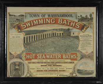
Photograph - Framed photograph of Warrnambool Salt Water Baths, c. 1920
... century. A building nearby housed marble cubicles with hot spa... century. A building nearby housed marble cubicles with hot spa ...This is a framed photograph of the men's pool at the Warrnambool Salt Water Baths. These Baths were originally built at the end of Gilles Street on the line of the present railway line in 1876 but were rebuilt in 1889 further north in Gilles Street when the railway line was opened. The water was pumped from the sea, initially by a windmill and later by a gas pump. The men's pool was 100 feet by 50 feet and the women's pool was 60 feet by 30 feet with bathing strictly segregated in the 19th century. A building nearby housed marble cubicles with hot spa baths with the water heated on the site and a caretaker's cottage completed the complex. Men's nude bathing was a feature of the early 20th century. Originally built by a local public company the Baths were taken over by the Warrnambool Council. These baths were superseded by the opening in 1961 of an Olympic Pool In Warrnambool. The site and the remaining buildings of the old sea water baths are now heritage-listed and today form part of the headquarters of the Warrnambool and District Historical Society.This photograph is of historical significance as a depiction of the Warrnambool Salt water Baths in the early 20th century. These Baths were the basis for promoting Warrnambool as a health and spa resort town in the late 19th and early 20th centuries.This is a framed black and white photograph of the men's pool at the Warrnambool Salt Water Baths. It depicts men and boys swimming in the circular pool and one male on the diving board. All these men are naked. There are other clothed males and clothed attendants wearing hats and waistcoats. The change rooms are on the right side of the photograph and there is a fence with trees behind. The photograph is mounted on cardboard with a gilt edge and is held in a wooden ridged frame behind glass. warrnambool sea water baths, sea baths, warrnambool pool, gilles street -
 Royal Australian and New Zealand College of Obstetricians & Gynaecologists (RANZCOG)
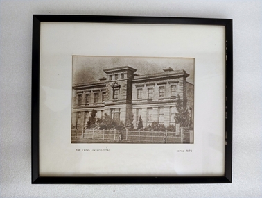
Photograph - Reproduction photograph, Charles Nettleton (1826-1902), The Lying In Hospital, circa 1870, c. 1868
... . There are trees in the grounds in from of the building. House and grounds... in a converted private house "Fairmont", which was located at 41 Albert ...This a cropped reproduction of a photograph taken by Charles Nettleton in c. 1868. Founded in 1856, the Lying-in Hospital was the second hospital to be established in Melbourne, after the Melbourne Hospital. It was, however, the first lying-in hospital in the Australasian colonies. The hospital was founded in a converted private house "Fairmont", which was located at 41 Albert Street, Eastern Hill (now East Melbourne). In 1858, the 'Lying-in Hospital' was relocated and opened in Madeline St, North Melbourne (now known as Swanston St, Carlton)." (The Women's) The building pictured here was eventually demolished in 1938 to make way for further extensions to the building. The original site in Albert Street was demolished in 1960, and the site is now occupied by the Melbourne Fire Brigade. A section of the wrought iron gates from the original site in Albert Street is held in RANZCOG's historical collection.Reproduction photograph of the front of a building. The building is three stories high. The lowest floor has eight large windows, with a door at centre, on the front side. One side window can also be seen at bottom right. There is a small flight of stairs leading up to the door. The second floor has eight windows in the same locations as the first floor, plus one additional window at centre instead of a door. The top floor is much smaller, with three small windows facing the front of the building. There are trees in the grounds in from of the building. House and grounds are enclosed behind a fence. There is a gate in the fence opposite the front door. Three figures are visible on the path outside the fence. One is at the centre of the image, and the other two are in the right hand corner. Text printed below image reads 'THE LYING - IN HOSPITAL circa 1870'. The image has been mounted and framed in a black wooden frame. An old display label for this image is attached to the back of the frame. handwritten text on backing board at back of work reads 'Probably prior to 1867 (J. Nattrass, 1968). Tape residue visible on backing board at upper right. A chain and two hooks have been added to the frame for hanging. -
 Bendigo Historical Society Inc.
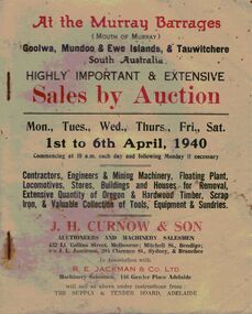
Document - IAN DYETT COLLECTION: AUCTION CATALOGUE - MURRAY BARRAGES
... Machinery, Floating Plant, Locomotives, Stores, Buildings and Houses... Machinery, Floating Plant, Locomotives, Stores, Buildings and Houses ...Two white covered auction catalogue with red and black printing for a sale at the Murray Barrages (Mouth of Murray) on 1st to 6th April, 1940. Sale was altered to one week later, the 8th to 13th April, 1940. For sale was Contractors, Engineers & Mining Machinery, Floating Plant, Locomotives, Stores, Buildings and Houses for Removal, Extensive Quantity of Oregon & Hardwood Timber, Scrap Iron, & Valuable Collection of Tools, Equipment & Sundries. Sold under instructions from the Supply & Tender Board, Adelaide. Auctioneers were J. H. Curnow & Son in association with R. E. Jackman & Co. Ltd. Some prices have been written in one catalogue. Black & white photos in the catalogue are: the Goolwa Barrage, Derrick Barge, 'Milang' Dipper Dredge, 'Captain Sturt' Steam Boat and Batter Pile Frame (for pile driving). The tattered copy has Mr. Curnow written in the top left corner. Contains description of some of the machinery.business, auctioneers, j h curnow & son pty ltd, ian dyett collection - auction catalogue - murray barrages, j h curnow & son, j l jamieson, r e jackman & co ltd, the supply & tender board adelaide, k p phillips -
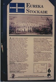
 Unions Ballarat
Camp Street, Ballarat from Eureka to Federation : a guide to its history and buildings, 2001
... (Pratt's Warehouse) Old YMCA building Wilson House Ballarat Office... Warehouse) Old YMCA building Wilson House Ballarat Office Systems ...A guide to the history of Camp Street Ballarat and its historical buildings. Camp Street has been the location of Unions Ballarat since 1887 - a chapter of the book is dedicated to Trades Hall - and was the home of the former labour newspaper, the Evening Echo. Camp Street was the site of the government camp at the time of the Eureka Stockade. Camp Street is now recognised as an Arts and Education precinct within the city of Ballarat. Headings: Gold fever The CAMPSTREET Project Titanic Bandstand Old Ballarat Free Library Complex "Point to the sky" "Perseus" Former government offices and court house Old Ballarat Court House Alfred Deakin Place Old Police Station (Ballarat Fine Art Gallery) Ballarat Fine Art Gallery Millennium Extension Bluestone Warehouse (Pratt's Warehouse) Old YMCA building Wilson House Ballarat Office Systems Ballarat Trades Hall The ANA Building Freemason's Hall Former Ballarat Trustees and Executors Agency Co. Ltd. Restaurant Former Evening Echo Building Ballarat Savings Bank (now The Ballarat Business Centre) Significant to the history of architecture and social life within the city of Ballarat. Direct relevance to Unions Ballarat building.Book; 48 pages. Cover: blue background; colour photos and maps pertinent to Ballarat; white lettering; title and compiler's name. btlc, ballarat trades hall, ballarat trades and labour council, evening echo, ballarat savings bank, ballarat business centre, freemason's hall - ballarat, ana building - ballarat, ballarat - camp street, wilson house - ballarat, ballarat office systems, ymca building, pratt's warehouse - ballarat, ballarat fine art gallery, old police station - ballarat, alfred deakin place, old courthouse - ballarat, perseus, point to the sky, old ballarat free library complex, titanic bandstand, campstreet project, gold mining - ballarat, architecture - history - ballarat -
 Eltham District Historical Society Inc
Film - Video (DVD), Frank Stokes, Stokes Family, 1950-1977
... for a permit to build a “packing shed” as no house building allowed... for a permit to build a “packing shed” as no house building allowed ...Various family scenes taken from outside the family home on the southeast corner of the intersection of Nyora Road and Pitt Street with Eucalyptus Road. Also, scenes of the Stokes Orchard and equipment used, construction of water reservoir at the end of Nyora Road near Reynolds Road and Diosma Road as well as early stages of the Stokes Orchard housing development. Frank Stokes worked as a qualified accountant at Kennons leather factory in Burnley, while living at 1 Thomas Street, Mitcham. He suffered from migraines and wanted to go back to the land (he had previously worked on farms and orchards since coming to Australia in 1926 both in WA and Vic.). He first travelled to the district by train in July 1942 to find land with the intention to establish an orchard. By chance he met Arthur Bird of Bird Orchard (bounded by Pitt Street, Eucalyptus Road and Wattle Grove) and they got talking over their common interest. Arthur put Frank up for the night and pointed out the land, 158 acres- Taylor Estate- £900, part of Crown Allotment 15, Section 5, Parish of Nillumbik (CA15) somewhat diagonally opposite Bird Orchard. He applied through the Riverina Agency to purchase the land who in turn had to get permission from Canberra to sell as there was a new government regulation banning land sales except for immediate production. He obtained a loan on his Mitcham house of £600 @ 5% and paid £450 deposit with quarterly payments of £15 over 5 years. The title to the property was issued May 15, 1946. He was helped and advised by Arthur Bird who farmed the neighbouring orchard. Early 1943 he took possession and would catch the train out to Eltham on Fridays after work and began building a hut for shelter and to lock up tools. He was able to pay a neighbour (Hawkins) to help with clearing and fencing 25 acres and with a horse and single furrowed plow, planted approximately 2,500 fruit trees - cherries, peaches, plums, almonds, pears, apricots and lemons as well as a few apples and oranges; a massive job. A huge problem was hares and rabbits eating all the new buds off the tiny trees. As well as laying poison he painted the trees with a mixture of cow manure and lime. Often working by moonlight. It was extremely difficult to get wire and wire netting because of the war but after much effort he obtained a permit from the Agricultural Department for supplies in March 1944. In February 1945 he applied for a permit to build a “packing shed” as no house building allowed. It was to be 33 feet x 21 feet and cost £312. Constructed mostly from second-hand materials, which was hard to obtain, especially iron for roofing. Frank finished work at Kennons October 31, 1945, and in March 1946 he sold the Mitcham house for £1230 plus £170 for furniture. The family of five then moved into a very unfinished at Eltham, which was a struggle to weatherproof. Eventually rooms were divided off and lined with hessian bags and whitewashed. Their income was firewood (cut and sold), selling rockery stones and cut sweet bursaria. (It was discovered during the 1940s that Bursaria contained the sunscreen compound Aesculin. The RAAF utilised this compound from Bursaria during WW2 for pilots and gunners.) The orchard’s first fruit sale was a 1/2 case of Le Vanq peaches in December 1947 - 8 shillings. In 1956 plans for house were drawn and Glen Iris bricks purchased (1956 Olympic Rings variant). The building of the house commenced in 1957 - 12 feet of original packing shed removed – and was completed in 1959. Water was connected from newly built pressure storage on the property at the end of 1959 and the electricity connection for the first time at 3pm on April 29, 1960. In the mid-1970s the Shire of Eltham divided the orchard up into numerous rate-able parcel lots, which became unaffordable for Frank. Consequently, Stokes Orchard was turned into a housing development by Macquarie Builders and marketed as the Stokes Orchard Estate in two stages; Stage 1 encompassing Scarlet Ash Court, Ironbark Close and Peppermint Grove bounded by Nyora and Eucalyptus roads c.1976 and Stage 2 encompassing Stokes Place, Orchard Way, The Crest and The Lookout bound by Nyora and Diosma roads c.1979. The development of Orchard Way, The Crest and The Lookout did not proceed as planned due to the lack of the sewer along Diosma Road and so many of the proposed lots were incorporated into five-acre parcels instead. With the arrival of the sewer along Diosma Road many years later, most of these five-acre parcels have since been subdivided many times.Representative of the orchard growing areas of ElthamMP4 00:24:39; 426MB Digital file only - Digitised by EDHS from a DVD copy on loan from Beryl Bradbury (nee Stokes), daughter of Frank Stokes. 24 min duration compilation of home movie Super 8mm film shot by Frank Stokes brother-in-law.beryl bradbury (nee stokes) collection, frank stokes, nyora road, stokes orchard, stokes orchard estate, stokes place, video recording -
 Bendigo Historical Society Inc.
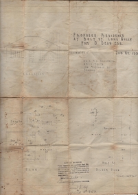
Document - JOAN LEVERSHA COLLECTION: HOUSE PLANS 12 BOLT STREET, LONG GULLY
... Various documents relating to the plan building of house... building of house at 12 Bolt Street, Long Gully. 1)Plan of proposed ...Various documents relating to the plan building of house at 12 Bolt Street, Long Gully. 1)Plan of proposed residence at Bolt Street, Long Gully for D. Dean Esq. job No. 133R plan drawn by A.S. and R.A. Eggleston Architects, 186 Mitchell Street, Bendigo. Stamp of the City of Bendigo approving the plan, signed by an official and dated 27/07/1950. 2) inside plan drawn in pencil and blue Biro, stamped by City of Bendigo and Bendigo Sewerage Authority. 3) Another drawing of section done in blue Biro. 4) Application for permit to construct No.4746. 5) Two pages on A4 paper written in blue pen, under the title City of Bendigo information for builders in regard to weatherboard buildings, long list of regulations to be followed, stamp of City of Bendigo and signature of D. Dean dated 27/07/1950. 6) small paper with various dimensions. All this documents are in a paper envelope marked Doug, house, 12 Bolt St.house, private, drawings -
 Eltham District Historical Society Inc
Photograph, David and Joan Armfield Studio House and Pottery (1953)
... Image 13 David and Joan Armfield Studio House and Pottery...Image 13 David and Joan Armfield Studio House and Pottery ...Image 13 David and Joan Armfield Studio House and Pottery Original building commenced by Roger Bell in 1953 Later completed by David and Joan Armfield The Alistair Knox Collection The Alistair Knox Collection is a series of mounted enlarged photos of mud brick houses and related subjects. The collection is understood to have been put together by Alistair Knox although it is the work of several unacknowledged photographers. For some years it was held by the Building Department of the former Eltham Shire Council and was then passed to our Society for safekeeping. Some of the photos have been used in Knox's books and from time to time some of them have been part of various historical displays. As far as we know there has not been a public display of the whole collection which numbers about forty photographs. The collection has been copied on to slides for the purpose of this meeting and to be retained as part of the Society's pictorial collection. Alistair Knox 1912 - 1986 is acknowledged as the founder of Eltham's mud brick building movement. Many of the buildings shown in the collection are of his design and he was also involved with the construction of several of them. Others are the work of his contemporaries and associates such as Peter Glass, Gordon Ford, and John Harcourt. (EDHS Newsletter No. 145 July 2002)Handwritten notes in pencil re details of building, year of construction, owner, designer, builder, etcdavid and joan armfield studio house, david armfield, houses, joan armfield, mud brick construction, roger bell, alistair knox collection -
Federation University Historical Collection
Photograph - Black and White, Former Ballarat Library, c1960
... was initially used. Land for additional building to house a Museum... was initially used. Land for additional building to house a Museum ...First known development on this site was the establishment of the Government Camp from the early 1850s. It was established to accommodate officials, troopers and police who were needed to administer the goldfields. Some permanent buildings were constructed. Lack of materials and bad weather prolonged the building of more permanent buildings and most men were still living in tents. Area was known as Camp Reserve. In 1864 a subdivision map shows the reserve be used for Public Buildings. Library applied for land on corner of Sturt and Camp Streets in 1878. 1880s plans show section of the reserve be used for a Free Library and Reading Room. Lease was granted and the old mining boardroom was initially used. Land for additional building to house a Museum and Art Gallery sought and agreement reached in 1882-3. Compensation paid to owners and library granted the land. Plans for a new library building with tower and lantern roof abandoned due to lack of funds. It wasn't until 1895 that a solution to funding was found and the library was able to begin constructing the complex of buildings on the Free Library Reserve. A number of changes have occurred since 1910s - the Classical Revival facade replaced with an angled facade in a stripped Classical style with Art Deco features and high parapet. Building is now part of Federation UniversityPhotograph of former library. Shows a two-storey rendered brick building in a Classical style. Some Art Deco features. Central pair of double windows with single window either side. High parapet above.government camp, goldfields, camp reserve, free library, reading room, sturt street, camp street, museum, art gallery, troopers, police, barracks, camp street -
 Eltham District Historical Society Inc
Slide, Joh Ebeli, The old Baker's house prior to demolition, corner of York Street and Main Road, Eltham, c.Sep. 1979
... of the house. The old weatherboard building, possibly dating from... of the house. The old weatherboard building, possibly dating from ...Photo taken immediately prior to the demolition of the old baker's shop on the corner of Main Road and York Street, Eltham. Joh Ebeli and Elwers Howard endeavoured to preserve some parts of the house. The old weatherboard building, possibly dating from the 1860s, comprised a dwelling with a shop in the front room opening off a timber verandah deck which directly fronted the Main Road footpath. At the rear is a brick building of much later date which was for many years used for the bakery. The buildings were demolished for flat construction. Publicity at the time was oriented toward moves to preserve the weatherboard building which came from a number of individuals including members of this society. The society had no official connection with any proposal to retain the building or any part of it on any other site. The issues involved were part of a wider consideration of the matter of preservation of historic buildings. In this case the Society and in particular the committee had been aware for some years of the impending demolition. The possibility of the preservation of the building had been canvassed on a number of occasions. The Society’s view was that whilst the baker’s shop was an interesting old building which contributed to the character of Main Road, it was not of sufficient importance to wage an organised campaign for its preservation. It considered that if the building were to be preserved for historical reasons it would be far more feasible to retain it in its present location than to re-build it on another site.35 mm colour positive transparency Mount - Agfachrome Professional black (Germany) 4 dotsmain road, old eltham bakery, york street -
 Bacchus Marsh & District Historical Society
Painting, View of Bacchus Marsh from Stamford Hill circa 1880s
... of Grant Street shows very few buildings. One house in the centre... of Grant Street shows very few buildings. One house in the centre ...The date of the scene depicted in this painting has not been identified. The painting has no artist signature or date. The view depicted is from an area close to the present day Madden Drive in Bacchus Marsh. The angle of the view suggests the artists viewpoint may have been from a spot close to the intersection of Madden Drive and Muir Street looking east over the town. Several buildings constructed in the 1860s and 1870s can be seen in the painting. These include Saint Andrews Presbyterian Church (now Uniting Church), built 1865, Stone Villa in Bennett Street, the Bacchus Marsh Court House, the former National Bank and the Border Inn, all on Main Street, and in the distance Saint Bernard’s Catholic Church. Buildings such as Simon’s Garage erected in 1913, on the corner of Main Street and Grant Street are not shown. In the foreground running horizontally Grant Street can be seen. The view of Grant Street shows very few buildings. One house in the centre of the picture is Murdoch's Cottage. A brick house constructed in 1868 on the corner of Grant Street and Waddell Street. To the right of the picture along Grant Street no buildings are shown. The store built by John Jory in 1890 at 60-62 Grant Street which survives as a building in 2025 is not shown. Some allowance for artistic interpretation must be allowed but based on what the scene depicts it suggests a scene of Bacchus Marsh in the late 1870s or 1880s. Print reproduction of an oil painting. Framed. Undated. Unsigned. BMDHS Location: AR/B12/Beside (on floor)views bacchus marsh vic., paintings bacchus marsh vic., landscapes bacchus marsh vic. -
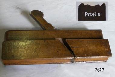
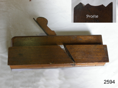 Flagstaff Hill Maritime Museum and Village
Tool - Wood moulding Plane, Christopher Gabriel, 18th Century
... to a house in Golden Lane, London and 1779 moved again to a home...-seven houses and commercial building. Christopher Gabriel s ...The story of Christopher Gabriel born on April 2, 1746, in Falmouth England is a tale of a poor boy who made good. Shortly before he turned thirteen years of age in 1759 he was apprenticed to a local master carpenter, recorded as a Mr Barnicot the master trained his apprentice well as we can assume by Christopher's later successes. The apprenticeship ended in 1766 after seven years when Christopher reached twenty. Then in 1768, he relocated to London walking the two hundred miles from Falmouth carrying his possessions in a sack. He no sooner arrived in London when he met Alice Trowell who became his wife in March 1769. They set up house on Albermarie Street Clerkenwell and by the first of 1770, Gabriel had begun his business of plane making. It has been speculated that Gabriel took over the shop of John Cogdell aided with an investment from his in-laws of 131 pounds. He went on to prosper as a plane maker and lumber merchant over the next forty years. His business did well and in 1774 Gabriel moved to a house in Golden Lane, London and 1779 moved again to a home in Ould Street London. By now Gabriel was making a name for himself and his business at this time was located at 32 Banner Street Golden Lane, the following year he purchased another home in Banner Street and 1793 purchased the house next door. At the time of his death in 1808, he owned twenty-seven houses and commercial building. Christopher Gabriel s descendants became quite prominent in England and his grandson, Sir Thomas Gabriel became the Sheriff of London and Middlesex in 1859 and the Lord Mayor of London 1866 and 1867. Gabriel was an extremely prolific plane maker with a lot of examples made in the 18th century can still be found today. He made good quality tools and was an innovator of several new plane designs. A vintage tool made by a well-known plane maker, this item was made commercially for firms and individuals that worked in wood and needed a tool that could give a decorative finish to timber. These planes came in various shapes and sizes to achieve a finish to timber surfaces and came in many sizes. A significant Christopher Gabriel plane from the mid to late 18th century that after 200 years can still be used today. Planes made by Gabriel are eagerly sought after by collectors. The tool gives us a snapshot of how furniture and other finishes were created on timber by the use of cutting edged hand tools. Tools that were themselves hand made shows the craftsmanship used during this time not only to make a tool such as the subject item but also the craftsmanship needed to produce a decorative or even finish that was needed for the finishing of timber items. Plane Moulding Reverse Ogee with two squares type Maker stamped Gabriel also stamped JB & No 9flagstaff hill, warrnambool, shipwrecked-coast, flagstaff-hill, flagstaff-hill-maritime-museum, maritime-museum, shipwreck-coast, flagstaff-hill-maritime-village -
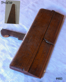
 Flagstaff Hill Maritime Museum and Village
Tool - Wood Moulding Plane, 1770-1809
... to a house in Golden Lane, London and 1779 moved again to a home...-seven houses and commercial building. Christopher Gabriel s ...The story of Christopher Gabriel born on April 2, 1746, in Falmouth England is a tale of a poor boy who made good. Shortly before he turned thirteen years of age in 1759 he was apprenticed to a local master carpenter, recorded as a Mr Barnicot the master trained his apprentice well as we can assume by Christopher's later successes. The apprenticeship ended in 1766 after seven years when Christopher reached twenty. Then in 1768, he relocated to London walking the two hundred miles from Falmouth carrying his possessions in a sack. He no sooner arrived in London when he met Alice Trowell who became his wife in March 1769. They set up house on Albermarie Street Clerkenwell and by the first of 1770, Gabriel had begun his business of plane making. It has been speculated that Gabriel took over the shop of John Cogdell aided with an investment from his in-laws of 131 pounds. He went on to prosper as a plane-maker and lumber merchant over the next forty years. His business did well and in 1774 Gabriel moved to a house in Golden Lane, London and 1779 moved again to a home in Ould Street London. By now Gabriel was making a name for himself and his business at this time was located at 32 Banner Street Golden Lane, the following year he purchased another home in Banner Street and 1793 purchased the house next door. At the time of his death in 1808, he owned twenty-seven houses and commercial building. Christopher Gabriel s descendants became quite prominent in England and his grandson, Sir Thomas Gabriel became the Sheriff of London and Middlesex in 1859 and the Lord Mayor of London 1866 and 1867. Gabriel was an extremely prolific plane-maker with a lot of examples made in the 18th century can still be found today. He made good quality tools and was an innovator of several new plane designs. A vintage tool made by a well-known plane-maker, this item was made commercially for firms and individuals that worked in wood and needed a tool that could give a decorative finish to timber. These planes came in various shapes and sizes to achieve a finish to timber surfaces and came in many sizes. A significant Christopher Gabriel plane from the mid to late 18th century that after 200 years can still be used today. Planes made by Gabriel are eagerly sought after by collectors. The tool gives us a snapshot of how furniture and other finishes were created on timber by the use of cutting edged hand tools. Tools that were themselves hand made shows the craftsmanship used during this time not only to make a tool such as the subject item but also the craftsmanship needed to produce a decorative or even finish that was needed for the finishing of timber items. Moulding multi patterned plane has a "5" long bladeStamped Maker C Gabriel (owner JB).flagstaff hill, warrnambool, shipwrecked-coast, flagstaff-hill, flagstaff-hill-maritime-museum, maritime-museum, shipwreck-coast, flagstaff-hill-maritime-village, side rabbet plane, gabriel m hobling -
 Flagstaff Hill Maritime Museum and Village
Tool - Moulding Plane, 1770-1809
... to a house in Golden Lane, London and 1779 moved again to a home...-seven houses and commercial building. Christopher Gabriel s ...The story of Christopher Gabriel born on April 2, 1746, in Falmouth England is a tale of a poor boy who made good. Shortly before he turned thirteen years of age in 1759 he was apprenticed to a local master carpenter, recorded as a Mr Barnicot the master trained his apprentice well as we can assume by Christopher's later successes. The apprenticeship ended in 1766 after seven years when Christopher reached twenty. Then in 1768, he relocated to London walking the two hundred miles from Falmouth carrying his possessions in a sack. He no sooner arrived in London when he met Alice Trowell who became his wife in March 1769. They set up house on Albermarie Street Clerkenwell and by the first of 1770, Gabriel had begun his business of plane making. It has been speculated that Gabriel took over the shop of John Cogdell aided with an investment from his in-laws of 131 pounds. He went on to prosper as a plane-maker and lumber merchant over the next forty years. His business did well and in 1774 Gabriel moved to a house in Golden Lane, London and 1779 moved again to a home in Ould Street London. By now Gabriel was making a name for himself and his business at this time was located at 32 Banner Street Golden Lane, the following year he purchased another home in Banner Street and 1793 purchased the house next door. At the time of his death in 1808, he owned twenty-seven houses and commercial building. Christopher Gabriel s descendants became quite prominent in England and his grandson, Sir Thomas Gabriel became the Sheriff of London and Middlesex in 1859 and the Lord Mayor of London 1866 and 1867. Gabriel was an extremely prolific plane-maker with a lot of examples made in the 18th century can still be found today. He made good quality tools and was an innovator of several new plane designs. A vintage tool made by a well-known plane-maker, this item was made commercially for firms and individuals that worked in wood and needed a tool that could give a decorative finish to timber. These planes came in various shapes and sizes to achieve a finish to timber surfaces and came in many sizes. A significant Christopher Gabriel plane from the mid to late 18th century that after 200 years can still be used today. Planes made by Gabriel are eagerly sought after by collectors. The tool gives us a snapshot of how furniture and other finishes were created on timber by the use of cutting edged hand tools. Tools that were themselves hand made shows the craftsmanship used during this time not only to make a tool such as the subject item but also the craftsmanship needed to produce a decorative or even finish that was needed for the finishing of timber items. Side Rabbet Plane Stamped Maker Gabriel (owner M Hobling).flagstaff hill, warrnambool, shipwrecked-coast, flagstaff-hill, flagstaff-hill-maritime-museum, maritime-museum, shipwreck-coast, flagstaff-hill-maritime-village, side rabbet plane, gabriel m hobling -
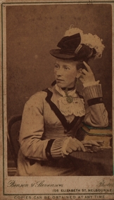 Federation University Historical Collection
Photograph - Sepia photograph, Benson & Stevenson, Emma Eliza Jane Phillips, c1860's
... Street, Ballarat North before building a house at Yendon. Thomas... Street, Ballarat North before building a house at Yendon. Thomas ...Emma was one of the first white children born in the Barrabool Hills (Geelong) to parents Richard and Elizabeth Phillips. Emma Eliza Jane Phillips was one of the first white children born in the Barrabool Hills (South Geelong) in the Port of New South Wales on 25/04/1844 and died at "Gracedale" Yendon 12/10/1925, age 81. Emma was the daughter of Richard Price Phillips and Elizabeth Anne Goodenough. Richard, originally a coach plater, was the licensee of "The Thistle Inn", a small hotel on the corner of Corio and Yarra Streets. Elizabeth appears to have had a dressmakers shop around the corner in Yarra Street. Emma married Thomas Watson in Ballarat in 18--? Thomas William Watson was born in Harston, Cambridge, England on10/11/1838 and died at "Gracedale", Yendon, Victoria, Australia 27/04/1920, age 81. He came to Australia seeking gold but instead of finding a fortune he worked for the Victorian Railways. After living in Sebastapol and Ballarat North they settled on a small farm at Yendon named "Gracedale" They were married in Ballarat at Saint Paul's Church of England in Ballarat East. Emma sang in the choir and was a member of the Ballarat Philharmonic Society. They first lived in Sebastapol, then Crompton Street, Ballarat North before building a house at Yendon. Thomas and Emma had 10 children, five boys and five girls, also rearing 3 grandchildren. Thomas and some of his sons ( including John Richard) helped to cut the original steps at Lal Lal to the bottom of the Lal Lal Falls.Photograph of a woman seated at a table with one elbow resting on books. Her jewllery has been hand painted in gold and the top book cover in green. C1860Front: Benson & Stevenson 108 Elizabeth Street Melbourne Copies can be obtained at any time Verso: Emma Eliza Jane (Phillips) Watson; 1844-1925; 81yrs; Died "Gracedale" Yendon, Vic; Born - South Geelong/Barrabool Hills; Dad's (John Richard Watson) motheremma eliza jane phillips, emma eliza jane watson, barrabool hills, yendon, thomas watson, richard price phillips, elizabeth goodenough, lal lal falls -
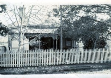 Wodonga & District Historical Society Inc
Photograph - Wodonga Atheneum
... concerning the best location for a building to house and reorganise... the best location for a building to house and reorganise ...From 1870 onwards discussions took place in Wodonga concerning the best location for a building to house and reorganise the holdings of the Wodonga Literary Institute and Free Library. The Literary Institute, originally the Belvoir Literary Group, had been formed prior to 1861 and changed its name with the renaming of the town in 1869. In 1873 a meeting was held to consider the re-organising of the Wodonga Literary Institute and Free Library as “there were a goodly number of valuable books and other property belonging to the Institution but they were not used, and it was a pity to see such valuable works and sketches shut up in a back store getting spoiled”. In October 1885 the Wodonga and Towong Sentinel reported that the Wodonga Athenaeum and Free Library committee were seeking a grant of £200 to add to the £200 already paid to purchase Hellerman’s buildings. In October 1886 the Wodonga Athenaeum in Hume Street was officially opened. It was designed by Gordon and Gordon, architects, and built by Stewart Bros. This building continued to house the Atheneum and its collection until 1915 when the new library in High Street was built. In 1916 the Athenaeum building was moved on drays drawn by Clydesdale horses, to 153 Lawrence Street and used as a private home since. The building is heritage listed. This image is one of a collection of glass negatives taken by Robert Prentice. The negatives are clearly identified as he inscribed in the glass a back-to-front capital R (Я) on to which was joined a capital P creating his mark ЯР. On the glass he would also scratch the name Prentice where he could, in this case along the bottom of the picket fence.This image is significant because it housed the Wodonga Literary Group and Free Library, the first library building in Wodonga.Black and white image of old wooden house with tin roof. Trees and a picket fence are at the front of the house.Written below picket fence: Atheneum Wodonga, Prenticewodonga literary institute and free library, atheneum wodonga, belvoir literary group, robert prentice -
 Melbourne Tram Museum
Slide - Set of 4, Keith Caldwell, 1962 and 1963
... of Parliament House. Notes the new building for the Windsor Hotel... and Spring Streets, photographed from the steps of Parliament House ...Set of four Agfa Colour slides, cardboard mounts, by Keith Caldwell dated 16 March 1962 of: .1 - W6 981, Route 90? Northcote Dundas St? and 1031 - City route 97 turning the corner at Bourke and Spring Streets, photographed from the steps of Parliament House. Notes the new building for the Windsor Hotel, Southern Cross Hotel and signs for The Society cafe, Salvation Army City Temple, Tye's ?, Metro Theatre and Molinans Imperial Hotel. Photo dated 16/3/1962. .2 - W7 1007, east bound in Bourke St, c1963, with destination of East Preston Route 88. Has adverts for Ilford and Twisties. Photo not dated, but post August 1962 - the Southern Cross Hotel opened during August 1962 (from https://en.wikipedia.org/wiki/Southern_Cross_Hotel - accessed 12/9/2019). In the background are signs for The Melbourne Hotel and the Salvation Army city temple. .3 - W6 992 at the intersection with Bourke and Swanston St, showing East Brunswick (should be City), route 96. Has the Myers, Wittners and Broadmans in the view. Also signs for Foys and Hiltons. Slide dated March 62 .4 - W6 1000 descending the Bourke St Hill to Swanston St, showing City Spencer St, route 97. In the background is a car parking building, Prudential building and a store "Canvas goods". Slide dated 13/3/1962In ink: .1 - "Bourke St 16-3-62" .2 - no date .3 - "Bourke Swast Mar 62" .4 - "Bourke 13.3.62 am"trams, tramways, bourke st, swanston st, route 97, northcote - dundas st, route 88, w6 class, w7 class, tram 981, tram 1031, tram 1000, tram 1007, tram 992 -
 Surrey Hills Historical Society Collection
Photograph, Sunbury Crescent, Surrey Hills looking towards the corner of Union Road, 1930s, 1930
... ; taken over by Timothy Leigh in 1893. The building housed...; taken over by Timothy Leigh in 1893. The building housed ...Date is approximate. This is one of a series of photos donated by Arthur Lyons. Lyons family history: Arthur's father, Fred Lyons initially worked for George Rea's cab service until he set up his own business. He started with a horse and hansom cab but in time he changed over to a motor vehicle and continued his service until 1960. Frederick Adolphus Lyons (1891-1980) was born in Surrey Hills, son of Thomas and Catherine Lyons. He married Elizabeth Ruby Hall in 1918. They lived at 55 Sunbury Crescent. The Lyons’ home in Sunbury Crescent was called ‘Knopshambury’ - this was probably a misspelling of Knockshanbally in Co Kilkenny, the birth place of Fred’s father, Thomas Edmund Josias Lyons (1846-1915). Arthur Lyons was born in Surrey Hills on 12 Jun 1920. He became a motor mechanic / welder and lived his whole life at 55 Sunbury Crescent. The donation was made while he was in hospital. He died shortly afterwards (23 Sep 1990). Donation was finalised by a neighbour, Mrs Florence Ann Armitstead, wife of Glen Victor Armitstead. Glen was a local hairdresser. They moved to 11 Sunbury Crescent after their marriage in 1939. Arthur had no relatives to distribute the material to. The buildings date from circa 1887 and extended some way down Sunbury Crescent. The address was 63 Sunbury Crescent on the corner of Union Road. Built by Albert Mills for the Premier Land Agency; taken over by Timothy Leigh in 1893. The building housed a variety of shops – initially the land agency, but later shops included at various times a fruiterer, florist, carpenter, fishmonger, upholsterer, plumber. However, by the time this photo was taken in the 1930s it was occupied by Triumph Press. The printing industry continued to have a lasting presence. Triumph Press was followed by Surrey Press and in 1970 New Life Publications moved to the site from Abbotsford. It was about this time that this original building was demolished to make way for a modern print works. Gradually the needs of the printing business absorbed other properties along the Union Road frontage. The boy in the photo is Arthur (Tiger) Lyons and beside him is Alf Johnson, the local printer. The Lyons family lived adjacent to these buildings at 55 Sunbury Crescent.Black and white photo of a section of double-storey terrace buildings in Sunbury Crescent Surrey Hills, taken looking towards the corner of Union Road. The bricks are two-toned and laid in herringbone pattern. The verandah on the 2nd story is filled in with cast-iron lacework panels. There are 2 vintage cars in front of the terrace. A young boy sits on the running board beside a man dressed in suit and hat. printers, vintage cars, sunbury crescent, victorian style, union road shops, arthur lyons, arthur frederick lyons, alf johnson, triumph press, surrey press, new life publications, timothy leigh,, albert mills -
 Ballarat Heritage Services
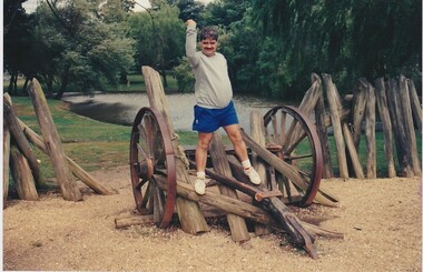
Digital photograph, Brenda & Jack Ford, Diorama Hut Exterior Signage, 14 December 1993
... photographs of the building that housed the exhibit, probably because... not take photographs of the building that housed the exhibit ...Please find 5 photographs taken by me & my wife Brenda, at Ballarat, on 14 December 1993. Unfortunately, I did not take photographs of the building that housed the exhibit, probably because I thought just how sad and pathetic the entire memorial display looked. It comprised a reconstructed slab hut and nearby a partly-rebuilt fence that represented the hastily-built Eureka Stockade. The signage that detailed the events surrounding the Eureka Stockade was affixed to the hut wall beside the entrance to the interior diorama. In the first photograph, you can see the dark, bare timber colour of the slab wood that held the signage plus (on the left side) one of the numerous holes in the slab walls. This made the display very cold and draughty in its interior. Once inside, you were confronted with an earthen, gravel and leafy floor, which became muddy, after rain, as it was on the day of our visit. The diorama was held in a glass and cement display case. with no lights on. It was dark inside the hut so the diorama was not easy to see unless you inserted a coin into a metal pay-box. Then lights would turn on and a recording of shouting and gunfire (representing the battle noise) would play. I remember the whole experience to be short and underwhelming. To get an idea of the scale of the diorama, you can see Brenda’s elbow & part torso to the left of the photograph labeled “diorama- hut exit”. Once outside the diorama’s slab hut, you could walk across to a partial representation of the stockade’s fortifications, complete with two wagon wheels. This space was also graveled to distinguish it from the rest of the green-lawn park. Finally, you walked up the hill, from the hut and outside display, to visit the old Eureka Stockade monument & cannons. This is still in existence today. Digital photographeureka stockade, sign, diorama, jack ford, brenda ford, memorial -
 Ballarat Heritage Services
Photograph - Digital photograph, Eureka Stockade Replica, 14/12/1993
... photographs of the building that housed the exhibit, probably because... not take photographs of the building that housed the exhibit ...Please find 5 photographs taken by me & my wife Brenda, at Ballarat, on 14 December 1993. Unfortunately, I did not take photographs of the building that housed the exhibit, probably because I thought just how sad and pathetic the entire memorial display looked. It comprised a reconstructed slab hut and nearby a partly-rebuilt fence that represented the hastily-built Eureka Stockade. The signage that detailed the events surrounding the Eureka Stockade was affixed to the hut wall beside the entrance to the interior diorama. In the first photograph, you can see the dark, bare timber colour of the slab wood that held the signage plus (on the left side) one of the numerous holes in the slab walls. This made the display very cold and draughty in its interior. Once inside, you were confronted with an earthen, gravel and leafy floor, which became muddy, after rain, as it was on the day of our visit. The diorama was held in a glass and cement display case. with no lights on. It was dark inside the hut so the diorama was not easy to see unless you inserted a coin into a metal pay-box. Then lights would turn on and a recording of shouting and gunfire (representing the battle noise) would play. I remember the whole experience to be short and underwhelming. To get an idea of the scale of the diorama, you can see Brenda’s elbow & part torso to the left of the photograph labeled “diorama- hut exit”. Once outside the diorama’s slab hut, you could walk across to a partial representation of the stockade’s fortifications, complete with two wagon wheels. This space was also graveled to distinguish it from the rest of the green-lawn park. Finally, you walked up the hill, from the hut and outside display, to visit the old Eureka Stockade monument & cannons. This is still in existence today. digital photographeureka, diorama, 1993, jack ford, brenda ford, eureka monument, memorial, eureka stockade, eureka diorama -
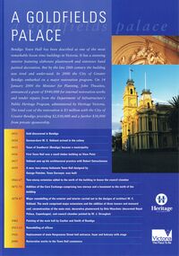 Bendigo Historical Society Inc.
Document - BENDIGO TOWN HALL ''A GOLDFIELD' PALACE'' LEAFLET, 2002
... extension added to the north of the building to house the council... extension added to the north of the building to house the council ...Bendigo Town Hall, Heritage Victoria ''A Goldfields Palace Blue Leaflet'' with coloured photographs and white text. Photographs courtesy of Westox Pty Ltd and the City of Greater Bendigo. 2002. Front page features the extensive work that would be undertaken for the restoration. A time line beginning 1851, gold discovered in Bendigo. 1854 German-born W. C. Vahland arrived in the colony. 1855 Town of Sandhurst (Bendigo) became a municipality. 1856 First Town Hall was a small timber building on View point. 1857 Vahland sets up his architectural practice with Robert Getzschmann. 1859 A new, two-storey Italianate Town hall designed by George Fletcher, Town Surveyor, was built. 1866-77 Two-storey extension added to the north of the building to house the council chamber. 1871-72 Addition of the Corn Exchange comprising two storeys and a basement to the north of the building. 1878-87 Major remodelling of the exterior and interior carried out to the designs of architect W. C. Vahland. The work comprised major extensions and the addition of three towers and mansard roof, reconstruction of the main stair, decorative plasterwork by Otto Waschatz (decorated Royal palace, Copenhagen), and council chamber painted by W. J. Straugher. 1902 Painting of the main hall by Coulter and Smith of Bendigo. 1913-15 Remodelling of offices. 1926 Replacement of main Hargreaves Street hall entrance, foyer and balcony with stage. 2000 Restoration works to the Town hall commence. The middle pages and the back show some of the conservation works that were required.bendigo, tourism, town hall restoration, 4-2000 www.heritage.vic.gov.au