Showing 664 items
matching state issue
-
 Kew Historical Society Inc
Plan, Melbourne & Metropolitan Board of Works : Borough of Kew : Detail Plan No.1591, 1905
The Melbourne and Metropolitan Board of Works (MMBW) plans were produced from the 1890s to the 1950s. They were crucial to the design and development of Melbourne's sewerage and drainage system. The plans, at a scale of 40 feet to 1 inch (1:480), provide a detailed historical record of Melbourne streetscapes and environmental features. Each plan covers one or two street blocks (roughly six streets), showing details of buildings, including garden layouts and ownership boundaries, and features such as laneways, drains, bridges, parks, municipal boundaries and other prominent landmarks as they existed at the time each plan was produced. (Source: State Library of Victoria)This plan forms part of a large group of MMBW plans and maps that was donated to the Society by the Mr Poulter, City Engineer of the City of Kew in 1989. Within this collection, thirty-five hand-coloured plans, backed with linen, are of statewide significance as they include annotations that provide details of construction materials used in buildings in the first decade of the 20th century as well as additional information about land ownership and usage. The copies in the Public Record Office Victoria and the State Library of Victoria are monochrome versions which do not denote building materials so that the maps in this collection are invaluable and unique tools for researchers and heritage consultants. A number of the plans are not held in the collection of the State Library of Victoria so they have the additional attribute of rarity.Original survey plan, issued by the MMBW to a contractor with responsibility for constructing sewers in the area identified on the plan within the Borough of Kew. The plan was at some stage hand-coloured, possibly by the contractor, but more likely by officers working in the Engineering Department of the Borough and later Town, then City of Kew. The hand-coloured sections of buildings on the plan were used to denote masonry or brick constructions (pink), weatherboard constructions (yellow), and public buildings (grey). That area of Kew bordered by Cotham Road, Park Hill Road, Ermington Lane (now Ermington Place), and Belmont Avenue contained some of the significant homes owned by Kew pioneers. Chief among these was ‘Park Hill’ on an enormous lot facing Park Hill Road. The Jubilee History of 1910 noted, six years after this plan was drawn, that: ‘Park Hill Road, forming the southern boundary of the cemetery, takes its name from Park Hill, the residence of Mr. Thomas Judd, who has resided there since December, 1852.’ Other named houses on the plan include ‘Ferndale’ facing Cotham Road; ‘Ermington’ adjacent to Judd’s Park Hill, facing Park Hill Road; and ‘Gilden’ and ‘Mont Belmont’ facing Belmont Avenue. Mont Belmont was designed by the architectural firm of Reed, Henderson and Smart for William George Lilley in 1887 and was completed in 1888. Lilley was Mayor of Kew in 1887-88, a Justice of the Peace and a member of the first Board of Guardians of Kew’s St. Hilary’s Church of England.melbourne and metropolitan board of works, detail plans, survey plans - borough of kew, mmbw 1591, cartography -
 Kew Historical Society Inc
Plan, Melbourne & Metropolitan Board of Works : Borough of Kew : Detail Plan No.1592, 1905
The Melbourne and Metropolitan Board of Works (MMBW) plans were produced from the 1890s to the 1950s. They were crucial to the design and development of Melbourne's sewerage and drainage system. The plans, at a scale of 40 feet to 1 inch (1:480), provide a detailed historical record of Melbourne streetscapes and environmental features. Each plan covers one or two street blocks (roughly six streets), showing details of buildings, including garden layouts and ownership boundaries, and features such as laneways, drains, bridges, parks, municipal boundaries and other prominent landmarks as they existed at the time each plan was produced. (Source: State Library of Victoria). This plan forms part of a large group of MMBW plans and maps that was donated to the Society by the Mr Poulter, City Engineer of the City of Kew in 1989. Within this collection, thirty-five hand-coloured plans, backed with linen, are of statewide significance as they include annotations that provide details of construction materials used in buildings in the first decade of the 20th century as well as additional information about land ownership and usage. The copies in the Public Record Office Victoria and the State Library of Victoria are monochrome versions which do not denote building materials so that the maps in this collection are invaluable and unique tools for researchers and heritage consultants. A number of the plans are not held in the collection of the State Library of Victoria so they have the additional attribute of rarity.Original survey plan, issued by the MMBW to a contractor with responsibility for constructing sewers in the area identified on the plan within the Borough of Kew. The plan was at some stage hand-coloured, possibly by the contractor, but more likely by officers working in the Engineering Department of the Borough and later Town, then City of Kew. The hand-coloured sections of buildings on the plan were used to denote masonry or brick constructions (pink), weatherboard constructions (yellow), and public buildings (grey). In MMBW Plan No.1592, the pink line indicates that area of the plan for which the contracting engineer was responsible. Included in the Plan are a number of primarily brick villas in a section of Belmont Avenue off Cotham Road. The house ‘Uvadale’ north of Belmont Avenue, and facing Cotham Road is also included in the contract. Excluded from the contract but shown on the Plan are ‘Glendonald’, ‘Mont Belmont’ and ‘Gilden’.melbourne and metropolitan board of works, detail plans, survey plans - borough of kew, mmbw 1592, cartography -
 Kew Historical Society Inc
Plan, Melbourne & Metropolitan Board of Works / Borough of Kew, Detail Plan No.1593, 1905
The Melbourne and Metropolitan Board of Works (MMBW) plans were produced from the 1890s to the 1950s. They were crucial to the design and development of Melbourne's sewerage and drainage system. The plans, at a scale of 40 feet to 1 inch (1:480), provide a detailed historical record of Melbourne streetscapes and environmental features. Each plan covers one or two street blocks (roughly six streets), showing details of buildings, including garden layouts and ownership boundaries, and features such as laneways, drains, bridges, parks, municipal boundaries and other prominent landmarks as they existed at the time each plan was produced. (Source: State Library of Victoria)This plan forms part of a large group of MMBW plans and maps that was donated to the Society by the Mr Poulter, City Engineer of the City of Kew in 1989. Within this collection, thirty-five hand-coloured plans, backed with linen, are of statewide significance as they include annotations that provide details of construction materials used in buildings in the first decade of the 20th century as well as additional information about land ownership and usage. The copies in the Public Record Office Victoria and the State Library of Victoria are monochrome versions which do not denote building materials so that the maps in this collection are invaluable and unique tools for researchers and heritage consultants. A number of the plans are not held in the collection of the State Library of Victoria so they have the additional attribute of rarity.Original survey plan, issued by the MMBW to a contractor with responsibility for constructing sewers in the area identified on the plan within the Borough of Kew. The plan was at some stage hand-coloured, possibly by the contractor, but more likely by officers working in the Engineering Department of the Borough and later Town, then City of Kew. The hand-coloured sections of buildings on the plan were used to denote masonry or brick constructions (pink), weatherboard constructions (yellow), and public buildings (grey). The laborious task of hand-tinting these Board of Works plans was not without hazards as is evidenced by Plan No. 1593. On the Plan, the original colourist spilt black and green ink, partially obscuring some parts. The most obvious casualty is ‘Clifton’ located on the corner of Cotham Road and Park Street [now Adeney Avenue]. Included in this Plan, and outlined in pink is that part of the section that the contracting engineer was tasked with completing. This included sewering on both sides of this part of Cotham Road, but excluded properties such as ‘Glendonald’ and ‘Monnington’. This area was to undergo a series of subdivisions including the ‘Clifton Estate’, which created housing lots on Adeney Avenue and Florence Avenue in 1916. The most notable occupant of Clifton was William Adeney [died 1893], a pioneer of Camperdown, after which Park Street was later renamed.melbourne and metropolitan board of works, detail plans, survey plans - borough of kew, mmbw 1593, cartography -
 Kew Historical Society Inc
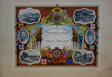
Document - Invitation to a Royal Review at Flemington, 1901
The correspondent of The Argus recorded that: "The Parliament of the Commonwealth was opened yesterday by the Duke, of Cornwall and York, under a Commission signed by Queen Victoria and subsequently endorsed by King Edward VII. The ceremony was marked by the splendour and solemn impressiveness which befitted its historic importance. ... To-day the Heir to the Throne will review some 15,000 Australian troops at Flemington. ... It is a function which, on a lesser scale, might have been arranged at any time for many years past; but it could never previously have conveyed the meaning it does now. Soldiering was popularly regarded as a pastime here until South Africa tried the mettle of our men. It is serious business from henceforth. Those who followed the nascent aspirations of the volunteer soldiery in Australia must be impressed at the rapidity of their fulfillment. ... The document design has artistic and aesthetic merit. While it is not rare, it is representative of the kinds of formal designs used for the Australian Commonwealth celebrations at the time of Federation, and is in excellent condition. Such items as this invitation have local, state and national historic significance as mementoes of a key moment in Australia's history. Locally, the invitation is part of a group of Federation-related items issued to James Maitland Campbell (and his wife). Campbell was three times mayor of Kew in the second half of the 19th Century and the owner of Ramornie in Pakington Street, one of the significant extant mansions in Kew. An invitation, mounted on card to the Royal Review held at Flemington racecourse on Friday 10 May 1901, as part of the Government of Victoria's Australian Commonwealth Celebrations. The border is vividly decorated with flags, shields and a large coat of arms. The photographic images depict various scenes of Flemington in Melbourne, in addition to two separate portraits of the Duke and Duchess of Cornwall and York. Illustrations of military servicemen on foot and horseback flank the central block of text. The invitation was addressed to Mr & Mrs J. M. Campbell. James Maitland Campbell had been Mayor of Kew in the years 1889-90, 1890-91 and 1892-93.Printed: AUSTRALIAN COMMONWEALTH CELEBRATIONS/ The Government of Victoria/ requests the honour of the presence of/ .../ AT THE/ ROYAL REVIEW/ at Flemington on Friday/ the 10th of May 1901. Handwritten on the dotted line: Mr. & Mrs. J. M. Campbellfederation events, royal review - 1901, james maitland campbell, federation -- invitations -
 Kew Historical Society Inc
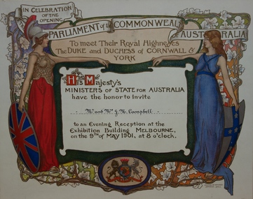
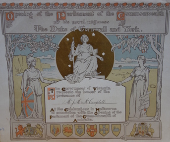
Document - Invitation To Meet their Royal Highnesses, the Duke and Duchess of Cornwall & York, Commonwealth of Australia, 1901
The commemorative booklet 'Our Invited Guests for the Opening of the First Parliament of the Commonwealth of Australia : An open directory of the guests invited to Melbourne, May 9th 1901' lists invitees from each Australian State. Mr & Mrs. J. M. Campbell are on this list, and recoded as residing at "Ramornie" 40 Pakington Street, Kew.The document design has artistic and aesthetic merit. While it is not rare, it is representative of the kinds of formal designs used for the Australian Commonwealth celebrations at the time of Federation, and is in excellent condition. Such items as this invitation have local, state and national historic significance as mementoes of a key moment in Australia's history. Locally, the invitation is part of a group of Federation-related items issued to James Maitland Campbell (and his wife). Campbell was three times mayor of Kew in the second half of the 19th Century and the owner of Ramornie in Pakington Street, one of the significant extant mansions in Kew.An invitation on card to Mr. & Mrs J. M. Campbell to attend an evening reception at the Exhibition Building, Melbourne, on 9 May 1901, to meet the Duke and Duchess of Cornwall as part of the celebrations of the opening of the first Federal Parliament. A figure of Britannia, in red dress and mailed vest holding a shield like the Union Jack, is on the left of the invitation; she reaches out her hand towards a younger female figure, representing Australia, who is dressed in blue and holds a shield which is white with a blue cross decorated with stars. The writing is on a scroll in the centre of the certificate, and there is a border of vines and vine leaves. The royal crest is at the base of the certificate.Printed on a banner across the top: 'IN CELEBRATION / OF THE / OPENING / PARLIAMENT of the COMMONWEALTH / OF AUSTRALIA' Printed below the banner: 'To meet Their Royal Highness / the DUKE and DUCHESS of CORNWALL & / YORK / His Majesty's / MINISTERS OF STATE FOR AUSTRALIA / have the honor to invite / [handwritten] Mr. & Mrs J. M. Campbell / to an Evening Reception at the / Exhibition Building MELBOURNE, / on the 9th of May 1901, at 8 o'clock'.federation -- australia -- 1901, parliament -- australia, invitations -- 1901 -
 Kew Historical Society Inc
Document - Invitation to the Opening of the Parliament of the Commonwealth, 1901
The correspondent of the Argus on 10 May 1901 wrote: "The Parliament of the Commonwealth was opened yesterday by the Duke, of Cornwall and York, under a Commission signed by Queen Victoria and subsequently endorsed by King Edward VII. The ceremony was marked by the splendour and solemn impressiveness which befitted its historic importance. An immense assemblage of spectators, drawn mainly, of course, from this state, but in part also from each of the other federated states, and including representatives of other portions of the British Empire and of foreign powers, thronged the spacious, stately, and joyously decorated edifice. The picture was magnificent. It must have printed itself indelibly on the sensitive minds of the thousands of Australians who were privileged to behold it. We may assume that artists will reproduce it in worthy and imperishable forms, and that from generation to generation it will be familiar in the households of the Commonwealth. Our children's children, we may gladly say to-day, will not be ashamed of the function which inaugurated the self-governing rights of the southern British Nation. Nothing was omitted which could add to the grandeur and significance of the occasion. In a broad sense the proceedings were perfectly intelligible to the vast and sympathetic gathering, though the natural limits of a single human voice had to be accepted. The King's son, with his consort and the Governor-General and Lady Hopetoun by his side, and supported by the Governors of the states and other eminent personages, fulfilled his doubly-attested Commission with a simple dignity and a modest manliness altogether admirable. The ceremony was a brilliant spectacle, and, in its sentiment and suggestiveness, an inspiration to a loyal and patriotic people."The document design has artistic and aesthetic merit. While it is not rare, it is representative of the kinds of formal designs used for the Australian Commonwealth celebrations at the time of Federation, and is in excellent condition. Such items as this invitation have local, state and national historic significance as mementoes of a key moment in Australia's history. Locally, the invitation is part of a group of Federation-related items issued to James Maitland Campbell (and his wife). Campbell was three times mayor of Kew in the second half of the 19th Century and the owner of Ramornie in Pakington Street, one of the significant extant mansions in Kew.An invitation, mounted on card for Mr & Mrs James Maitland Campbell to an evening reception at the Exhibition Building, Melbourne, on 9 May 1901, to meet the Duke and Duchess of Cornwall as part of the celebrations of the opening of the first Federal Parliament. A figure of Britannia, in red dress and mailed vest holding a shield like the Union Jack, is on the left of the invitation; she reaches out her hand towards a younger female figure, representing Australia, who is dressed in blue and holds a shield which is white with a blue cross decorated with stars. The writing is on a scroll in the centre of the certificate, and there is a border of vines and vine leaves. The royal crest is at the base of the certificate. James Maitland Campbell of ‘Ramornie’ in Pakington Street was mayor of Kew on three occasionsFront, printed. gold ink: "His Majesty's Ministers of State for the Commonwealth of Australia request the honour of the presence of / Mr & Mrs J. M. Campbell (handwritten) / In the Exhibition Building, Melbourne, on Thursday, 9th May, 1901, to witness / the Opening of the Parliament of the Commonwealth. / Edmund Barton / Prime Minister." Front, bottom left, printed: "The Young Queen / Her hand was still on her sword hilt - the spur was still on her heel ... (and further text) KIPLING'S COMMONWEALTH ODE."australia -- federation -- 1901, invitations, parliament -- opening -- 1901, james maitland campbell -
 Kew Historical Society Inc
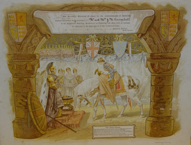
Document - Invitation to the Opening of the Parliament of the Commonwealth by His Royal Highness the Duke of York and Cornwall, Tom Carrington, 1901
The Correspondent for The Argus on 10 May 1901 described the opening on 9 May as: "The Parliament of the Commonwealth was opened yesterday by the Duke, of Cornwall and York, under a Commission signed by Queen Victoria and subsequently endorsed by King Edward VII. The ceremony was marked by the splendour and solemn impressiveness which befitted its historic importance. An immense assemblage of spectators, drawn mainly, of course, from this state, but in part also from each of the other federated states, and including representatives of other portions of the British Empire and of foreign powers, thronged the spacious, stately, and joyously decorated edifice. The picture was magnificent. It must have printed itself indelibly on the sensitive minds of the thousands of Australians who were privileged to behold it. We may assume that artists will reproduce it in worthy and imperishable forms, and that from generation to generation it will be familiar in the households of the Commonwealth. Our children's children, we may gladly say to-day, will not be ashamed of the function which inaugurated the self-governing rights of the southern British Nation. Nothing was omitted which could add to the grandeur and significance of the occasion. In a broad sense the proceedings were perfectly intelligible to the vast and sympathetic gathering, though the natural limits of a single human voice had to be accepted. The King's son, with his consort and the Governor-General and Lady Hopetoun by his side, and supported by the Governors of the states and other eminent personages, fulfilled his doubly-attested Commission with a simple dignity and a modest manliness altogether admirable. The ceremony was a brilliant spectacle, and, in its sentiment and suggestiveness, an inspiration to a loyal and patriotic people."The document design has artistic and aesthetic merit. While it is not rare, it is representative of the kinds of formal designs used for the Australian Commonwealth celebrations at the time of Federation, and is in excellent condition. Such items as this invitation have local, state and national historic significance as mementoes of a key moment in Australia's history. Locally, the invitation is part of a group of Federation-related items issued to James Maitland Campbell (and his wife). Campbell was three times mayor of Kew in the second half of the 19th Century and the owner of Ramornie in Pakington Street, one of the significant extant mansions in Kew.A colour lithograph mounted on card which is an invitation to the Opening of the First Commonwealth Parliament of Australia, 9 May 1901. The invitation was sent to Mr J.M. & Mrs Campbell. John Longstaff and Norman Lindsay’s design for the invitation includes symbolic female figures and coats of arms of the British and Australian Commonwealth. The central figure represents Justice. At her feet a crown and sceptre are laid, ‘to denote that the monarch will always acquiesce in laws passed by Parliament, provided they are just.’ On the left appears a figure of Britannia, above the royal coat of arms and in front of the white cliffs of England; on the right is a female figure representing Australia, with one hand out-stretched and above the Australian Coat of Arms. Behind her is a pastoral scene; she stands beneath a gum tree. At the top is a border of waratahs; on the left is a border of oak. The six states are represented in shields at the bottom of the card.Front, printed. gold ink: "Opening of the Parliament of the Commonwealth By his Royal Highness The Duke of Cornwall and York / The Government of Victoria requests the honour of the presence of / Mr. J . M. and Mrs. Campbell (handwritten / At the Celebrations in Melbourne in connection with the Opening of the Parliament of the Commonwealth of Australia."parliament of australia -- 1901, royal exhibition building -- melbourne (vic), james maitland campbell -
 Kew Historical Society Inc
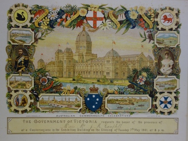
Document - Invitation to a ‘Conversazione’ in the Exhibition Building, George Austin, 1901
A report in the Ballarat Star on 8 May 1901 recorded that: "THE CONVERSAZIONE. A GREAT SUCCESS. The conversazion given by the Government of Victoria at the Exhibition was very largely patronised. the guests includ ing the Prime Minister and a goodly proportion of the distinguished personages now in Melbourne. A programme of high-class music was gone through, and refreshments were served during the evening. Australian wines were very prominent."The document design has artistic and aesthetic merit. While it is not rare, it is representative of the kinds of formal designs used for the Australian Commonwealth celebrations at the time of Federation, and is in excellent condition. Such items as this invitation have local, state and national historic significance as mementoes of a key moment in Australia's history. Locally, the invitation is part of a group of Federation-related items issued to James Maitland Campbell (and his wife). Campbell was three times mayor of Kew in the second half of the 19th Century and the owner of Ramornie in Pakington Street, one of the significant extant mansions in Kew.Colour lithograph mounted on card to an evening event, a conversazione, held in the Exhibition Building on the evening of Tuesday 7th May 1901, as part of the Australian Commonwealth Celebrations. The recipients of the invitation were Mr and Mrs James Maitland Campbell of Kew. The Government of Victoria hosted the event. The invitation shows an etching of the Exhibition Building, surrounded by an ornate border of heraldic shields, portraits of the Duke and Duchess, views of Perth, Adelaide, Melbourne, Sydney, Brisbane and Hobart, and native flora (including wattle, waratah, pink heath, Sturt’s desert pea, and flannel flower), and native fauna (kookaburra, possum, lyre bird, cockatoo and koala). The royal crest ‘Dieu et mon droit’ and the Australian crest, ‘Advance Australia’ are also included.Printed: UNITED AUSTRALIA 1901 / ONE FLAG / ONE HOPE / ONE DESTINY; AUSTRALIAN COMMONWEALTH CELEBRATIONS / THE GOVERNMENT OF VICTORIA requests the honour of the presence of / / at a Conversazione in the Exhibition Building on the Evening of Tuesday 7th May 1901 at 8 P.M. Handwritten: Mr & Mrs J. M. Campbell.sands & mcdougall ltd, documents - invitations, first commonwealth parliament 1901, james maitland campbell (1847-1930), ramornie, ramornie - pakington street -
 Kew Historical Society Inc
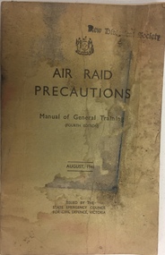
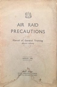
Manual, H E Daw, Air Raid Precautions : Manual of General Training, 1941
... their training during the Second World War. The booklet was issued... during the Second World War. The booklet was issued by the State ...Part of a suite of materials used by Air Raid Precautions (ARP) wardens in Kew in the Second World War. Air raid wardens managed groups of people in using air raid facilities that were constructed throughout the district. The ARP scheme was based on that developed in the United Kingdom.Primary resources showing the materials and advice developed to protect civilians on the home front. Examples of such support in the Kew Historical Society's collection includes advice for authorised community representatives, insignia and equipment.72-page manual provided to air raid wardens following their training during the Second World War. The booklet was issued by the State Emergency Council for Civil Defence, Victoria. Fourth Edition, 1941second world war 1939-1945, second world war - air raid precautions, air raid precautions - manuals, arp, air raid precautions, state emergency services victoria 1939-1945, second world war — air raid precautions, world war 2 — 1939-1945, home front — kew (vic.) -
 Kew Historical Society Inc
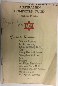
Booklet, Australian Comforts Fund (Victorian Divsion), Guide to Knitting, 1940
The Australian Comforts Fund (ACF) was first formed on 24 August 1916 from a number of State based organisations that had been individually formed at the beginning of the First World War to send comforts to the troops. With the close of the war, the ACF officially ceased to exist on 16 April 1920, only to be revived in 1939 with the outbreak of the Second World War. The ACF provided embarkation kits to troops containing items such as soap, clothes, tobacco, razors and barley sugar. The ACF officially closed on June 27, 1946. (AWM website)20-page booklet issued by the Australian Comforts Fund (Victorian Division) in World War II, providing advice on how to knit a range of articles for this on 'Active Service'. The instructions provided are textual rather than graphical.Signature of owner (?): "Elizabeth Clifford"australian comforts fund (victoria), knitting -
 Kew Historical Society Inc
Journal, The Kewriosity Sheet Vol.4 No.3 : October 1982
St Paul's School for the Blind and Visually Handicapped / p1. Volunteer drivers needed [Kew Community Bus] / p1. East Central Weights and Measures Union / p1. Uniting Church East Kew - Dairy [sic] for October / p2. Save the Children Fund / p2. Kew Skin Diving Club / p2. Kew Library [Deafness Awareness Week] / p2. St Paul's luncheon and fashion parade / p2. Scouts 50th anniversary dinner [6th Kew Scouts] / p3. Kew Garden Club / p3. R.A.A.V. [Rheumatism and Arthritis Association of Victoria] / p3. Patchwork quilts [Exhibition; Australian Quilters Association] / p3. Cabaret [Kew Baptist Church Young People's Cabaret] / p3. Hyde Park Fellowship [Hyde Park Uniting Church] / p3. Annual Fete [St Paul's East Kew] / p3. They built well: State School No. 1075, Peel Street, Kew [school history] / p4. Native Plant Group / p4.The Kewriosity Sheet (1979-83) was first published in the City of Kew (Victoria) in June 1979 as a two-sided 'community newssheet'. It aimed to: 'share news about Kew happenings and Kew people, and to exchange ideas about living in Kew'. Later issues gradually evolved into a 4-page, quarto sized publication. The Kewriosity Sheet was superseded by the Kew Council publication 'Kewriosity' (1983-1994).non-fictionSt Paul's School for the Blind and Visually Handicapped / p1. Volunteer drivers needed [Kew Community Bus] / p1. East Central Weights and Measures Union / p1. Uniting Church East Kew - Dairy [sic] for October / p2. Save the Children Fund / p2. Kew Skin Diving Club / p2. Kew Library [Deafness Awareness Week] / p2. St Paul's luncheon and fashion parade / p2. Scouts 50th anniversary dinner [6th Kew Scouts] / p3. Kew Garden Club / p3. R.A.A.V. [Rheumatism and Arthritis Association of Victoria] / p3. Patchwork quilts [Exhibition; Australian Quilters Association] / p3. Cabaret [Kew Baptist Church Young People's Cabaret] / p3. Hyde Park Fellowship [Hyde Park Uniting Church] / p3. Annual Fete [St Paul's East Kew] / p3. They built well: State School No. 1075, Peel Street, Kew [school history] / p4. Native Plant Group / p4.community publications --- kew (vic.), the kewriosity sheet, newsletters - kew (vic.) -
 Kew Historical Society Inc
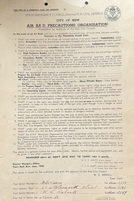
Document, Arnall & Jackson: Printers & Stationers, City of Kew: Air Raid Precautions Organisation, June 1940
Air Raid Precautions Organisations were formed in each State in Australia during the Second World War. In Victoria they were organised by the State Emergency Council (Victoria) for Civil Defence. In Melbourne, the organisations were locally based in municipalities. Within a municipality, areas were organised into sectors.Twelve point instructions distributed by the District Warden's Office, Town Hall, Kew in June 1940 and issued by the authority and with the approval of the Kew City Council, W. D. Birrell (Town Clerk), outlining advice for residents in the event of an air raid. City of Kew seal at top right. The document was issued to residents in Sector 9. It was printed by Arnall & Jackson, 115 Barkly Street, W. Brunswick.Signed [Sector Warden] F. J. [sic] Warry, 65 Molesworth Street; [Senior Warden] K. L. Robertssecond world war, city of kew, wwii, air raid precautions organisation -
![State School, Fernshawe / [by] Nicholas Caire, circa 1876](/media/collectors/550653872162f11fb04854aa/items/5777443dd0cdd10a5c0fa4c9/item-media/57774498d0cdd10a5c0fd7bf/item-fit-380x285.jpg) Kew Historical Society Inc
Kew Historical Society IncPhotograph, State School, Fernshawe, c. 1876
Nicholas Caire was born on Guernsey in the Channel Islands in 1837. He arrived in Adelaide with his parents in about 1860. In 1867, following photographic journeys in Gippsland, he opened a studio in Adelaide. From 1870 to 1876 he lived and worked in Talbot in Central Victoria. In 1876 he purchased T. F. Chuck's studios in the Royal Arcade Melbourne. In 1885, following the introduction of dry plate photography, he began a series of landscape series, which were commercially successful. As a photographer, he travelled extensively through Victoria, photographing places few of his contemporaries had previously seen. He died in 1918. Reference: Jack Cato, 'Caire, Nicholas John (1837–1918)', Australian Dictionary of Biography.An original, rare photograph from the series 'Views of Victoria: General Series' by the photographer, Nicholas Caire (1837-1918). The series of 60 photographs that comprise the series was issued c. 1876 and reinforced a neo-Romantic view of the Australian landscape to which a growing nationalist movement would respond. Nicholas Caire was active as a photographer in Australia from 1858 until his death in 1918. His vision of the Australian bush and pioneer life had a counterpart in the works of Henry Lawson and other nationalist poets, authors and painters.Albumen Silver Photograph mounted on boardprinted in ink on support l.c.: STATE SCHOOL, FERNSHAWE. / COPYRIGHT REGISTERED. printed in ink on support reverse c.: VIEWS OF VICTORIA. / (GENERAL SERIES.) / No. 5. / STATE SCHOOL, FERNSHAWE. / This educational institution occupies one of the most romantic situations of any of the State Schools in Victoria. / On either side of it runs a river and a creek, whilst immediately surrounding it are a great many large fern trees. / The background comprises many giants of the forest. In the centre of the picture stands a stump, about 60 feet / high, which has evidently been struck by lightning. The neighbourhood, not being a very populous one, furnishes / but 30 children for educational training. printed in ink on support reverse l.c.l.: J.W. FORBES, Agent, printed in ink on support reverse l.c.: ANGLO-AUSTRALASIAN PHOTOGRAPHIC COMPANY, MELBOURNE printed in ink on support reverse l.c.r.: 10 Temple Court, Collins Street West.nicholas caire (1837-1918), landscape photography -
![Dandenong State Forest, at Fern Tree Gully / [by] Nicholas Caire, circa 1876](/media/collectors/550653872162f11fb04854aa/items/577750a4d0cdd10a5c15e22b/item-media/57775147d0cdd10a5c165a58/item-fit-380x285.jpg) Kew Historical Society Inc
Kew Historical Society IncPhotograph, Anglo-Australasian Photographic Company, Dandenong State Forest, at Fern Tree Gully, c. 1876
Nicholas Caire was born on Guernsey in the Channel Islands in 1837. He arrived in Adelaide with his parents in about 1860. In 1867, following photographic journeys in Gippsland, he opened a studio in Adelaide. From 1870 to 1876 he lived and worked in Talbot in Central Victoria. In 1876 he purchased T. F. Chuck's studios in the Royal Arcade Melbourne. In 1885, following the introduction of dry plate photography, he began a series of landscape series, which were commercially successful. As a photographer, he travelled extensively through Victoria, photographing places few of his contemporaries had previously seen. He died in 1918. Reference: Jack Cato, 'Caire, Nicholas John (1837–1918)', Australian Dictionary of Biography, National Centre of Biography, Australian National UniversityAn original, rare photograph from the series 'Views of Victoria: General Series' by the photographer, Nicholas Caire (1837-1918). The series of 60 photographs that comprise the series was issued c. 1876 and reinforced a neo-Romantic view of the Australian landscape to which a growing nationalist movement would respond. Nicholas Caire was active as a photographer in Australia from 1858 until his death in 1918. His vision of the Australian bush and pioneer life had a counterpart in the works of Henry Lawson and other nationalist poets, authors and painters.Albumen silver photograph on boardprinted in ink on support l.c.: DANDENONG STATE FOREST, AT FERN TREE GULLY. / COPYRIGHT REGISTERED. printed in ink on support reverse c.: VIEWS OF VICTORIA. / (GENERAL SERIES.) / No. 12. / DANDENONG STATE FOREST, AT FERN TREE GULLY. / Fern Tree Gully is one of the favourite resorts for pleasure-seekers on holiday occasions. This scene is taken / from the camping ground at the entrance to the Gully. The residence in the centre of the picture is that of the / Forest-keeper, Mr. Kennedy, who has charge of the Dandenong State Forest. The trees on the hill at the back of / the residence, through apparently diminutive, are in reality gigantic ones, measuring in many instances from 15 to / 20 feet in circumference at the base. printed in ink on support reverse l.c.l.: J.W. FORBES, Agent, printed in ink on support reverse l.c.: ANGLO-AUSTRALASIAN PHOTOGRAPHIC COMPANY, MELBOURNE. printed in ink on support reverse l.c.r.: 10 Temple Court, Collins Street West.nicholas caire (1837-1918), landscape photography, ferntree gully -
 Kew Historical Society Inc
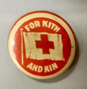
Badge - Fundraising Button, For Kith and Kin, 1915
Frances Rigg was a local business identity in Kew, at one stage managing the local branch of the English, Scottish and Australian (ES&A) Bank at 175 High Street from c. 1920 until the 1940s. After Francis Rigg’s death, the collection of buttons and medallions was inherited by his son, Ken Rigg (1922-2014). The collection was subsequently donated to the Kew Historical Society in 2015 by Francis' grandson, Adrian Rigg, at the time of the Gallipoli & Beyond Commemoration in 2015. The collection covers a period of almost 40 years. The majority of the buttons are patriotic buttons, issued and sold during and immediately after the First World World War (1914-1918) to raise funds for national and overseas causes. The collection also includes a number of locally significant sporting event buttons and sporting club medallions, issued in the 1920s and 1930s.Patriotic and other pressed tin buttons and badges were produced in large numbers in the first decades of the twentieth century. By nature, insubstantial and ephemeral, they have not always survived. The collections of badges, buttons and medallions in the Kew Historical Society collection is homogenous and yet diverse, ranging from buttons sold to raise funds for the war efforts in 1914-18 and 1939-45, to those used at festivals and sporting events. Because of the manufacturing process, many surviving buttons and badges have been affected by inadequate storage, suffering from oxidisation and physical damage. These survivors are now historically and socially significant artefacts, revealing much about the attitudes and values of the period in which they were produced. Their widespread distribution means that they are frequently significant at a local, state, national and international level.Metal badge with a printed illustration of a Red Cross flag and printed text on a red ink background surrounded by a white border. The Commonwealth Button Fund issued buttons of this design for a Victorian Red Cross appeal in July 1915. All funds raised during the appeal were to be used for the support of the Australian Red Cross and the servicemen in their care. Between 300,000-400,000 of these buttons were distributed."For Kith and Kin"patriotic buttons, badges, first world war 1914-1918 -
 Kew Historical Society Inc
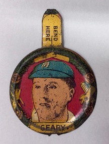
Badge - Souvenir Button, Geary, 1928-1929
Frances Rigg was a local business identity in Kew, at one stage managing the local branch of the English, Scottish and Australian (ES&A) Bank at 175 High Street from c. 1920 until the 1940s. After Francis Rigg’s death, the collection of buttons and medallions was inherited by his son, Ken Rigg (1922-2014). The collection was subsequently donated to the Kew Historical Society in 2015 by Francis' grandson, Adrian Rigg, at the time of the Gallipoli & Beyond Commemoration in 2015. The collection covers a period of almost 40 years. The majority of the buttons are patriotic buttons, issued and sold during and immediately after the First World World War (1914-1918) to raise funds for national and overseas causes. The collection also includes a number of locally significant sporting event buttons and sporting club medallions, issued in the 1920s and 1930s.Patriotic and other pressed tin buttons and badges were produced in large numbers in the first decades of the twentieth century. By nature, insubstantial and ephemeral, they have not always survived. The collections of badges, buttons and medallions in the Kew Historical Society collection is homogenous and yet diverse, ranging from buttons sold to raise funds for the war efforts in 1914-18 and 1939-45, to those used at festivals and sporting events. Because of the manufacturing process, many surviving buttons and badges have been affected by inadequate storage, suffering from oxidisation and physical damage. These survivors are now historically and socially significant artefacts, revealing much about the attitudes and values of the period in which they were produced. Their widespread distribution means that they are frequently significant at a local, state, national and international level.A tin buttonhole button from a series of 16 badges issued by Amalgamated Press. George Geary (1893-1981) was an English Cricketer who played in a number of tests against Australia including the 1928-29 tour. The button includes a tab which states ‘Bend Me’ which was a simple method of attaching the badge to a lapel."Geary"george geary, cricket, test cricket -
 Kew Historical Society Inc
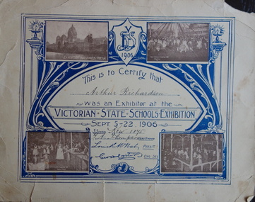
Certificate, Victorian State Schools Exhibition, 1906, 1906
This work forms part of the collection assembled by the historian Dorothy Rogers, that was donated to the Kew Historical Society by her son John Rogers in 2015. The manuscripts, photographs, maps, and documents were sourced by her from both family and local collections or produced as references for her print publications. Many were directly used by Rogers in writing ‘Lovely Old Homes of Kew’ (1961) and 'A History of Kew' (1973), or the numerous articles on local history that she produced for suburban newspapers. Most of the photographs in the collection include detailed annotations in her hand. The Rogers Collection provides a comprehensive insight into the working habits of a historian in the 1960s and 1970s. Together it forms the largest privately-donated collection within the archives of the Kew Historical Society.A certificate issued to Arthur Richardson of Kew School for participating in the Victorian State Schools Exhibition of 1906. Arthur Richardson was the uncle of the historian Dorothy Rogers. [Recipient] "Arthur Richardson" / [State School] "Kew, 1075" / [Head Teacher] "T. A. Thompson" /kew primary school, arthur richardson, victorian state schools exhibition, 1906, dorothy rogers, state school exhibition, exhibition, certificate, education -
 Kew Historical Society Inc
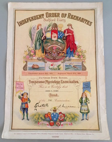
Certificate - School Certificate, Independent Order of Rechabites, Victorian State School Temperance Physiology Examination, George M Rogers, 1941, 1941
George Rogers was the brother of the donor and the son of Dorothy Rogers.This work forms part of the collection assembled by the historian Dorothy Rogers, that was donated to the Kew Historical Society by her son John Rogers in 2015. The manuscripts, photographs, maps, and documents were sourced by her from both family and local collections or produced as references for her print publications. Many were directly used by Rogers in writing ‘Lovely Old Homes of Kew’ (1961) and 'A History of Kew' (1973), or the numerous articles on local history that she produced for suburban newspapers. Most of the photographs in the collection include detailed annotations in her hand. The Rogers Collection provides a comprehensive insight into the working habits of a historian in the 1960s and 1970s. Together it forms the largest privately-donated collection within the archives of the Kew Historical Society.Temperance Physiology Examination. An illuminated certificate issued to George H. Rogers in 1941.The certificate issued by the Independent Order of Rechabites certified that he had passed the Victorian State School Temperance Physiology Examination independent order of rechabites, george m rogers, school certificates -
 Kew Historical Society Inc
Manual - Training Manual, State Emergency Council for Civil Defence, Air Raid Precautions : Manual of General Training, August 1941, 1941
... ) for Air Raid Precautions issued by the State Emergency Council... Precautions issued by the State Emergency Council for Civil Defence ...Part of a suite of materials used by Air Raid Precautions (ARP) wardens in Kew in the Second World War. Air raid wardens managed groups of people in using air raid facilities that were constructed throughout the district. The ARP scheme was based on that developed in the United Kingdom.Primary resources showing the materials and advice developed to protect civilians on the home front. Examples of such support in the Kew Historical Society's collection includes advice for authorised community representatives, insignia and equipment.An illustrated manual of general training (fourth edition) for Air Raid Precautions issued by the State Emergency Council for Civil Defence in Victoria.second world war 1939-1945, air raids, arp, air raid precautions, state emergency services victoria 1939-1945, second world war — air raid precautions, state emergency council for civil defence victoria — 1939-1945, world war 2 — 1939-1945, home front — kew (vic.) -
 Kew Historical Society Inc
Plan, Melbourne & Metropolitan Board of Works : Borough of Kew : Detail Plan No.1291, 1905
The Melbourne and Metropolitan Board of Works (MMBW) plans were produced from the 1890s to the 1950s. They were crucial to the design and development of Melbourne's sewerage and drainage system. The plans, at a scale of 40 feet to 1 inch (1:480), provide a detailed historical record of Melbourne streetscapes and environmental features. Each plan covers one or two street blocks (roughly six streets), showing details of buildings, including garden layouts and ownership boundaries, and features such as laneways, drains, bridges, parks, municipal boundaries and other prominent landmarks as they existed at the time each plan was produced. (Source: State Library of Victoria). This plan forms part of a large group of MMBW plans and maps that was donated to the Society by the Mr Poulter, City Engineer of the City of Kew in 1989. Within this collection, thirty-five hand-coloured plans, backed with linen, are of statewide significance as they include annotations that provide details of construction materials used in buildings in the first decade of the 20th century as well as additional information about land ownership and usage. The copies in the Public Record Office Victoria and the State Library of Victoria are monochrome versions which do not denote building materials so that the maps in this collection are invaluable and unique tools for researchers and heritage consultants. A number of the plans are not held in the collection of the State Library of Victoria so they have the additional attribute of rarity.Original survey plan, issued by the MMBW to a contractor with responsibility for constructing sewers in the area identified on the plan within the Borough of Kew. The plan was at some stage hand-coloured, possibly by the contractor, but more likely by officers working in the Engineering Department of the Borough and later Town, then City of Kew. The hand-coloured sections of buildings on the plan were used to denote masonry or brick constructions (pink), weatherboard constructions (yellow), and public buildings (grey). A detail plan of part of Studley Park bordered by the major streets of Hodgson Street, Stevenson Street and Studley Park Road. Included on the plan are a number of significant Studley Park mansions in existence at the beginning of the 20th century. The unnamed street shown in the middle of the plan is McEvoy Street. The most important house still extant is Campion House, formerly named Dalsraith [Dalswraith] and Glendalough, owned since the 1940s by the Society of Jesus. Campion House can be seen on the corner of Hodgson and Studley Park Road. Its stables at the rear of the block have now been incorporated into a contemporary residence. An interesting feature of the plan is the 1910 annotation by Ed Seitz, professional designing engineer. Is Seitz the contractor who modified the MMBW original?melbourne and metropolitan board of works, detail plans, mmbw 1291, cartography -
 Kew Historical Society Inc
Plan, Melbourne and Metropolitan Board of Works, Melbourne & Metropolitan Board of Works : Borough of Kew : Detail Plan No.1294 & 1295, 1904
The Melbourne and Metropolitan Board of Works (MMBW) plans were produced from the 1890s to the 1950s. They were crucial to the design and development of Melbourne's sewerage and drainage system. The plans, at a scale of 40 feet to 1 inch (1:480), provide a detailed historical record of Melbourne streetscapes and environmental features. Each plan covers one or two street blocks (roughly six streets), showing details of buildings, including garden layouts and ownership boundaries, and features such as laneways, drains, bridges, parks, municipal boundaries and other prominent landmarks as they existed at the time each plan was produced. (Source: State Library of Victoria). This plan forms part of a large group of MMBW plans and maps that was donated to the Society by the Mr Poulter, City Engineer of the City of Kew in 1989. Within this collection, thirty-five hand-coloured plans, backed with linen, are of statewide significance as they include annotations that provide details of construction materials used in buildings in the first decade of the 20th century as well as additional information about land ownership and usage. The copies in the Public Record Office Victoria and the State Library of Victoria are monochrome versions which do not denote building materials so that the maps in this collection are invaluable and unique tools for researchers and heritage consultants. A number of the plans are not held in the collection of the State Library of Victoria so they have the additional attribute of rarity.Original survey plan, issued by the MMBW to a contractor with responsibility for constructing sewers in the area identified on the plan within the Borough of Kew. The plan was at some stage hand-coloured, possibly by the contractor, but more likely by officers working in the Engineering Department of the Borough and later Town, then City of Kew. The hand-coloured sections of buildings on the plan were used to denote masonry or brick constructions (pink), weatherboard constructions (yellow), and public buildings (grey).The streets and built structures in MMBW Detail Plan 1294 & 1295 were surveyed in 1903 and released to contractors in 1904. This plan is one of two in the collection where the lithographers amalgamated two separate plans. Both plans include sections of Studley Park. Dominating the south and west corners of Kew Junction are the Clifton and Kew Hotels. The Kew Hotel, owned by Patrick O’Shaughnessy was one of the oldest in Kew. MMBW plans were amended over time to take account of new subdivisions such as that which created Merrion Place. Of the four mansions shown in Studley Park Road, three remain – ‘Field Place’, the home of Frances Henty, ‘Leaghur’ and ‘Darley’. ‘Byram’ (later ‘Goathland’, then ‘Tara Hall’) was an architectural marvel. Designed in 1888 by E.G. Kilburn for the paper magnate George Ramsden, it was demolished in 1960. While an earlier sale of the southern section of Byram had created Tara Avenue in 1927, the demolition of the house in 1960 enabled the extension of Tara Avenue northward.melbourne and metropolitan board of works, detail plans, mmbw 1294, mmbw 1295, cartography -
 Kew Historical Society Inc
Plan, Melbourne & Metropolitan Board of Works : Borough of Kew : Detail Plan No.1296, 1904
The Melbourne and Metropolitan Board of Works (MMBW) plans were produced from the 1890s to the 1950s. They were crucial to the design and development of Melbourne's sewerage and drainage system. The plans, at a scale of 40 feet to 1 inch (1:480), provide a detailed historical record of Melbourne streetscapes and environmental features. Each plan covers one or two street blocks (roughly six streets), showing details of buildings, including garden layouts and ownership boundaries, and features such as laneways, drains, bridges, parks, municipal boundaries and other prominent landmarks as they existed at the time each plan was produced. (Source: State Library of Victoria)This plan forms part of a large group of MMBW plans and maps that was donated to the Society by the Mr Poulter, City Engineer of the City of Kew in 1989. Within this collection, thirty-five hand-coloured plans, backed with linen, are of statewide significance as they include annotations that provide details of construction materials used in buildings in the first decade of the 20th century as well as additional information about land ownership and usage. The copies in the Public Record Office Victoria and the State Library of Victoria are monochrome versions which do not denote building materials so that the maps in this collection are invaluable and unique tools for researchers and heritage consultants. A number of the plans are not held in the collection of the State Library of Victoria so they have the additional attribute of rarity.Original survey plan, issued by the MMBW to a contractor with responsibility for constructing sewers in the area identified on the plan within the Borough of Kew. The plan was at some stage hand-coloured, possibly by the contractor, but more likely by officers working in the Engineering Department of the Borough and later Town, then City of Kew. The hand-coloured sections of buildings on the plan were used to denote masonry or brick constructions (pink), weatherboard constructions (yellow), and public buildings (grey). This area was once known as O’Shaughnessy’s Paddock. O’Shaughnessy was the licensee of the Kew Hotel. The ‘Paddock’ or farm was for many years the closest farm to Melbourne. By 1903, when this plan was surveyed and lithographed, little of the farm remained. The area is dominated by a ‘clay hole’, on the site of the current Foley Reserve. It was used by Smart’s Brickyard from the 1880s until 1911, when the Council purchased it for a rubbish dump. It is notable as the site is one of the few industrial operations to have existed in Kew. By 1903, urban development was characterised by larger houses fronting Barkers Road and brick and weatherboard villas in Foley Street. Nearer the pit, weatherboard houses predominated. Foley Street bisected the triangular block and continued right to Denmark Street. At this stage, a house impeded the through road, only allowing access via a right of way to High Street.melbourne and metropolitan board of works, detail plans, mmbw 1296, cartography -
 Kew Historical Society Inc
Plan, Melbourne & Metropolitan Board of Works : Borough of Kew : Detail Plan No.1297, 1904
The Melbourne and Metropolitan Board of Works (MMBW) plans were produced from the 1890s to the 1950s. They were crucial to the design and development of Melbourne's sewerage and drainage system. The plans, at a scale of 40 feet to 1 inch (1:480), provide a detailed historical record of Melbourne streetscapes and environmental features. Each plan covers one or two street blocks (roughly six streets), showing details of buildings, including garden layouts and ownership boundaries, and features such as laneways, drains, bridges, parks, municipal boundaries and other prominent landmarks as they existed at the time each plan was produced. (Source: State Library of Victoria)This plan forms part of a large group of MMBW plans and maps that was donated to the Society by the Mr Poulter, City Engineer of the City of Kew in 1989. Within this collection, thirty-five hand-coloured plans, backed with linen, are of statewide significance as they include annotations that provide details of construction materials used in buildings in the first decade of the 20th century as well as additional information about land ownership and usage. The copies in the Public Record Office Victoria and the State Library of Victoria are monochrome versions which do not denote building materials so that the maps in this collection are invaluable and unique tools for researchers and heritage consultants. A number of the plans are not held in the collection of the State Library of Victoria so they have the additional attribute of rarity.Original survey plan, issued by the MMBW to a sewage contractor with responsibility for constructing sewers in the area identified on the plan within the Borough of Kew. The plan was at some stage hand-coloured, possibly by the contractor, but more likely by officers working in the Engineering Department of the Borough and later Town, then City of Kew. The hand-coloured sections of buildings on the plan were used to denote masonry or brick constructions (pink), weatherboard constructions (yellow), and public buildings (grey). This plan of Kew encompasses the area bounded by Barkers Road, High Street and Stevenson Street. Because of the angle created by High Street, a number of houses on the northern side of High Street are shown. The area is dominated by one of the great original landholdings in Kew, described here as the ‘Findon Paddock’. ‘Findon’, the house from which the name of the paddock was taken fronts Stevenson Street and was clearly a rambling structure. The best-known occupant of Findon was Henry ‘Money Miller’ who bought the house in 1871. Miller was a member of Victoria’s first parliament and assisted in the framing of its constitution. Findon was to be subdivided as early as 1912, when the Findon Subdivision was advertised to be sold by auction. In the plan of the subdivision, the original house is not shown, so, presumably it had previously been demolished. Fincham & Son moved the organ, built by Henry Willis, which was installed in the house, first to ‘Whernside’ in Toorak, and later to the Box Hill Methodist Church.melbourne and metropolitan board of works, detail plans, mmbw 1297, cartography, kew (vic.) — municipal collection -
 Kew Historical Society Inc
Plan, Melbourne & Metropolitan Board of Works : Borough of Kew : Detail Plan No.1301, 1910
The Melbourne and Metropolitan Board of Works (MMBW) plans were produced from the 1890s to the 1950s. They were crucial to the design and development of Melbourne's sewerage and drainage system. The plans, at a scale of 40 feet to 1 inch (1:480), provide a detailed historical record of Melbourne streetscapes and environmental features. Each plan covers one or two street blocks (roughly six streets), showing details of buildings, including garden layouts and ownership boundaries, and features such as laneways, drains, bridges, parks, municipal boundaries and other prominent landmarks as they existed at the time each plan was produced. (Source: State Library of Victoria)This plan forms part of a large group of MMBW plans and maps that was donated to the Society by the Mr Poulter, City Engineer of the City of Kew in 1989. Within this collection, thirty-five hand-coloured plans, backed with linen, are of statewide significance as they include annotations that provide details of construction materials used in buildings in the first decade of the 20th century as well as additional information about land ownership and usage. The copies in the Public Record Office Victoria and the State Library of Victoria are monochrome versions which do not denote building materials so that the maps in this collection are invaluable and unique tools for researchers and heritage consultants. A number of the plans are not held in the collection of the State Library of Victoria so they have the additional attribute of rarity.Original survey plan, issued by the MMBW to a contractor with responsibility for constructing sewers in the area identified on the plan within the Borough of Kew. The plan was at some stage hand-coloured, possibly by the contractor, but more likely by officers working in the Engineering Department of the Borough and later Town, then City of Kew. The hand-coloured sections of buildings on the plan were used to denote masonry or brick constructions (pink), weatherboard constructions (yellow), and public buildings (grey). Throughout its history, the land in what is known today as Studley Ward of the City of Boroondara has been subject to continuing subdivision. This is evident in Plan 1301, where later hands have modified the original map to include streets created subsequent to the printing of the plan in 1904. Other annotations such as the ‘Reserved for Road Purposes’ beside the Yarra never eventuated. The plan continued to be modified to at least 1953, when a later hand noted that a particular site was ‘Property site P. McIntyre house’ in Swinton Avenue. Two significant houses in the area are outlined on the plan: ‘Swinton’ on the corner of the streets then named Effey and Maud Streets (now Swinton Avenue) and ‘Fairhaven’ [unnamed] in Stevenson Street. The gardens of the two David Syme owned mansions of ‘Blythswood’ and ‘Rockingham’, stretching down to the River Yarra, are also represented.melbourne and metropolitan board of works, detail plans, mmbw 1301, cartography -
 Kew Historical Society Inc
Plan, Melbourne & Metropolitan Board of Works : Borough of Kew : Detail Plan No.1302, 1910
The Melbourne and Metropolitan Board of Works (MMBW) plans were produced from the 1890s to the 1950s. They were crucial to the design and development of Melbourne's sewerage and drainage system. The plans, at a scale of 40 feet to 1 inch (1:480), provide a detailed historical record of Melbourne streetscapes and environmental features. Each plan covers one or two street blocks (roughly six streets), showing details of buildings, including garden layouts and ownership boundaries, and features such as laneways, drains, bridges, parks, municipal boundaries and other prominent landmarks as they existed at the time each plan was produced. (Source: State Library of Victoria)This plan forms part of a large group of MMBW plans and maps that was donated to the Society by the Mr Poulter, City Engineer of the City of Kew in 1989. Within this collection, thirty-five hand-coloured plans, backed with linen, are of statewide significance as they include annotations that provide details of construction materials used in buildings in the first decade of the 20th century as well as additional information about land ownership and usage. The copies in the Public Record Office Victoria and the State Library of Victoria are monochrome versions which do not denote building materials so that the maps in this collection are invaluable and unique tools for researchers and heritage consultants. A number of the plans are not held in the collection of the State Library of Victoria so they have the additional attribute of rarity.Original survey plan, issued by the MMBW to a contractor with responsibility for constructing sewers in the area identified on the plan within the Borough of Kew. The plan was at some stage hand-coloured, possibly by the contractor, but more likely by officers working in the Engineering Department of the Borough and later Town, then City of Kew. The hand-coloured sections of buildings on the plan were used to denote masonry or brick constructions (pink), weatherboard constructions (yellow), and public buildings (grey). The absence of buildings and or property in Kew facing the Yarra is the most notable feature of this plan. Walmer Street and its bridge stretched, then and now, from Studley Park Road to Victoria Street, Richmond. On the Richmond side of the Yarra, there was evidence in 1904 of industry (‘Wool shed’; Soap Works’) and entertainment (‘Skittle Alley’). In reality, another Plan (No.1303) shows Chinese Gardens bordering the Yarra on the Kew side and buildings in Young Street.melbourne and metropolitan board of works, detail plans, mmbw 1302, cartography -
 Kew Historical Society Inc
Plan, Melbourne & Metropolitan Board of Works : Borough of Kew : Detail Plan No.1350, 1910
The Melbourne and Metropolitan Board of Works (MMBW) plans were produced from the 1890s to the 1950s. They were crucial to the design and development of Melbourne's sewerage and drainage system. The plans, at a scale of 40 feet to 1 inch (1:480), provide a detailed historical record of Melbourne streetscapes and environmental features. Each plan covers one or two street blocks (roughly six streets), showing details of buildings, including garden layouts and ownership boundaries, and features such as laneways, drains, bridges, parks, municipal boundaries and other prominent landmarks as they existed at the time each plan was produced. (Source: State Library of Victoria). This plan forms part of a large group of MMBW plans and maps that was donated to the Society by the Mr Poulter, City Engineer of the City of Kew in 1989. Within this collection, thirty-five hand-coloured plans, backed with linen, are of statewide significance as they include annotations that provide details of construction materials used in buildings in the first decade of the 20th century as well as additional information about land ownership and usage. The copies in the Public Record Office Victoria and the State Library of Victoria are monochrome versions which do not denote building materials so that the maps in this collection are invaluable and unique tools for researchers and heritage consultants. A number of the plans are not held in the collection of the State Library of Victoria so they have the additional attribute of rarity.Original survey plan, issued by the MMBW to a contractor with responsibility for constructing sewers in the area identified on the plan within the Borough of Kew. The plan was at some stage hand-coloured, possibly by the contractor, but more likely by officers working in the Engineering Department of the Borough and later Town, then City of Kew. The hand-coloured sections of buildings on the plan were used to denote masonry or brick constructions (pink), weatherboard constructions (yellow), and public buildings (grey). MMBW Plan No. 1350 depicts the western end of Studley Park on the north side of the Studley Park Road. ‘Raheen’, then the home of Sir Henry Wrixon is named, the plan identifying those parts of the house that were built of brick and timber. The two houses between Raheen and the River Yarra are also shown. Other parts of the plan show neighbouring streets: Yarra Street, Studley Park Avenue, Studley Street and Fenwick Street. Each, apart from Fenwick Street was subsequently renamed. At the corner of Fenwick and Stawell Streets, the home of Joseph Butterworth Coombs, later called ‘Hope Mansell’, is represented but unnamed.melbourne and metropolitan board of works, detail plans, mmbw 1350, cartography -
 Kew Historical Society Inc
Plan, Melbourne & Metropolitan Board of Works : Borough of Kew : Detail Plan No.1561, 1905
The Melbourne and Metropolitan Board of Works (MMBW) plans were produced from the 1890s to the 1950s. They were crucial to the design and development of Melbourne's sewerage and drainage system. The plans, at a scale of 40 feet to 1 inch (1:480), provide a detailed historical record of Melbourne streetscapes and environmental features. Each plan covers one or two street blocks (roughly six streets), showing details of buildings, including garden layouts and ownership boundaries, and features such as laneways, drains, bridges, parks, municipal boundaries and other prominent landmarks as they existed at the time each plan was produced. (Source: State Library of Victoria). This plan forms part of a large group of MMBW plans and maps that was donated to the Society by Mr Poulter, City Engineer of the City of Kew in 1989. Within this collection, thirty-five hand-coloured plans, backed with linen, are of statewide significance as they include annotations that provide details of construction materials used in buildings in the first decade of the 20th century as well as additional information about land ownership and usage. The copies in the Public Record Office Victoria and the State Library of Victoria are monochrome versions which do not denote building materials so that the maps in this collection are invaluable and unique tools for researchers and heritage consultants. A number of the plans are not held in the collection of the State Library of Victoria so they have the additional attribute of rarity.Original survey plan, issued by the MMBW to a contractor with responsibility for constructing sewers in the area identified on the plan within the Borough of Kew. The plan was at some stage hand-coloured, possibly by the contractor, but more likely by officers working in the Engineering Department of the Borough and later Town, then City of Kew. The hand-coloured sections of buildings on the plan were used to denote masonry or brick constructions (pink), weatherboard constructions (yellow), and public buildings (grey). MMBW Detail Plan 1561 outlines those residences in the area bordered by Burke Road, Loxton Street, Mount Street and Barkers Road that had been constructed by 1905 when the land was surveyed. At this time, the area nearest Burke Road had been subdivided and developed whereas the lands to the west were as yet undeveloped. The houses represented are not named on the Plan.melbourne and metropolitan board of works, detail plans, mmbw 1561, cartography -
 Kew Historical Society Inc
Plan, Melbourne and Metropolitan Board of Works, Borough of Kew : Detail Plan No.1562, 1905
The Melbourne and Metropolitan Board of Works (MMBW) plans were produced from the 1890s to the 1950s. They were crucial to the design and development of Melbourne's sewerage and drainage system. The plans, at a scale of 40 feet to 1 inch (1:480), provide a detailed historical record of Melbourne streetscapes and environmental features. Each plan covers one or two street blocks (roughly six streets), showing details of buildings, including garden layouts and ownership boundaries, and features such as laneways, drains, bridges, parks, municipal boundaries and other prominent landmarks as they existed at the time each plan was produced. (Source: State Library of Victoria). This plan forms part of a large group of MMBW plans and maps that was donated to the Society by the Mr Poulter, City Engineer of the City of Kew in 1989. Within this collection, thirty-five hand-coloured plans, backed with linen, are of statewide significance as they include annotations that provide details of construction materials used in buildings in the first decade of the 20th century as well as additional information about land ownership and usage. The copies in the Public Record Office Victoria and the State Library of Victoria are monochrome versions which do not denote building materials so that the maps in this collection are invaluable and unique tools for researchers and heritage consultants. A number of the plans are not held in the collection of the State Library of Victoria so they have the additional attribute of rarity.Original survey plan, issued by the MMBW to a contractor with responsibility for constructing sewers in the area identified on the plan within the Borough of Kew. The plan was at some stage hand-coloured, possibly by the contractor, but more likely by officers working in the Engineering Department of the Borough and later Town, then City of Kew. The hand-coloured sections of buildings on the plan were used to denote masonry or brick constructions (pink), weatherboard constructions (yellow), and public buildings (grey). MMBW detail plan No.1562, in contrast to No.1561 includes the names of a large number of houses: in Barkers Road: ‘Ashwick’, ‘Owasso’, ‘Anadiha’, ‘Eurobin’, ‘Carlsruhe’, ‘Arlington’ and ‘Altyre’. Unnamed but clearly represented on the plan is what was then known as the ‘Auburn Heights Recreation Club’, which at this stage included a Bowling Green, a Croquet Green and two Tennis Courts. On the plan, Brougham Place, as it was then known, is represented. It was later renamed Daniell Place. The aforementioned Arlington is now the junior campus of Preshil. melbourne and metropolitan board of works, detail plans, mmbw 1562, cartography -
 Kew Historical Society Inc
Plan, Melbourne & Metropolitan Board of Works : Borough of Kew : Detail Plan No.1563, 1905
The Melbourne and Metropolitan Board of Works (MMBW) plans were produced from the 1890s to the 1950s. They were crucial to the design and development of Melbourne's sewerage and drainage system. The plans, at a scale of 40 feet to 1 inch (1:480), provide a detailed historical record of Melbourne streetscapes and environmental features. Each plan covers one or two street blocks (roughly six streets), showing details of buildings, including garden layouts and ownership boundaries, and features such as laneways, drains, bridges, parks, municipal boundaries and other prominent landmarks as they existed at the time each plan was produced. (Source: State Library of Victoria)This plan forms part of a large group of MMBW plans and maps that was donated to the Society by the Mr Poulter, City Engineer of the City of Kew in 1989. Within this collection, thirty-five hand-coloured plans, backed with linen, are of statewide significance as they include annotations that provide details of construction materials used in buildings in the first decade of the 20th century as well as additional information about land ownership and usage. The copies in the Public Record Office Victoria and the State Library of Victoria are monochrome versions which do not denote building materials so that the maps in this collection are invaluable and unique tools for researchers and heritage consultants. A number of the plans are not held in the collection of the State Library of Victoria so they have the additional attribute of rarity.Original survey plan, issued by the MMBW to a contractor with responsibility for constructing sewers in the area identified on the plan within the Borough of Kew. The plan was at some stage hand-coloured, possibly by the contractor, but more likely by officers working in the Engineering Department of the Borough and later Town, then City of Kew. The hand-coloured sections of buildings on the plan were used to denote masonry or brick constructions (pink), weatherboard constructions (yellow), and public buildings (grey). This plan covers the area between Barkers Road, Wrixon Street, Sackville Street and Brougham Place, much of it now occupied by Carey Baptist Grammar and Preshil schools. This was an area of large and prestigious homes in 1903, some with formally laid-out gardens, such as ‘Tower Hill’ and ‘Opawa’. ‘Kalimna’ was built in 1890-91 for William H. Jarman, an accountant, and ‘Blackhall’ at the same time for W.H. Roberts. Blackhall was to be acquired by the Salvation Army in 1915 and renamed ‘Catherine Booth Girls’ Home’. The Home accommodated girls, aged between 4 and 16. Kalimna and Blackhall are of significance as typical and intact late Victorian mansions and as such are two key Victorian buildings to have been built in Kew. Both Blackhall and Kalimna are now part of Preshil. ‘Fairview’ was for a long time occupied by the Sisters of St. Joseph of Cluny as a care home for the elderly, but it is now part of Carey Grammar School, as are the grounds of ‘Wagga Merne’, ‘Weemutta’, ‘Blakely’, ‘Daheim’ and ‘Mildura’ (later ‘Urangeline’), the last being particularly impressive in 1903, with a tennis court, conservatory, outhouses, and two bathrooms!melbourne and metropolitan board of works, detail plans, mmbw 1563, cartography -
 Kew Historical Society Inc
Plan, Melbourne & Metropolitan Board of Works : Borough of Kew : Detail Plan No.1564, 1905
The Melbourne and Metropolitan Board of Works (MMBW) plans were produced from the 1890s to the 1950s. They were crucial to the design and development of Melbourne's sewerage and drainage system. The plans, at a scale of 40 feet to 1 inch (1:480), provide a detailed historical record of Melbourne streetscapes and environmental features. Each plan covers one or two street blocks (roughly six streets), showing details of buildings, including garden layouts and ownership boundaries, and features such as laneways, drains, bridges, parks, municipal boundaries and other prominent landmarks as they existed at the time each plan was produced. (Source: State Library of Victoria)This plan forms part of a large group of MMBW plans and maps that was donated to the Society by the Mr Poulter, City Engineer of the City of Kew in 1989. Within this collection, thirty-five hand-coloured plans, backed with linen, are of statewide significance as they include annotations that provide details of construction materials used in buildings in the first decade of the 20th century as well as additional information about land ownership and usage. The copies in the Public Record Office Victoria and the State Library of Victoria are monochrome versions which do not denote building materials so that the maps in this collection are invaluable and unique tools for researchers and heritage consultants. A number of the plans are not held in the collection of the State Library of Victoria so they have the additional attribute of rarity.Original survey plan, issued by the MMBW to a contractor with responsibility for constructing sewers in the area identified on the plan within the Borough of Kew. The plan was at some stage hand-coloured, possibly by the contractor, but more likely by officers working in the Engineering Department of the Borough and later Town, then City of Kew. The hand-coloured sections of buildings on the plan were used to denote masonry or brick constructions (pink), weatherboard constructions (yellow), and public buildings (grey). In 1905, when Plan No.1564 was printed, that part of Kew bordered by Brougham Place (now Daniell Place), Mount Street, Sackville Street and Ross Street was already the location of a number of large mansions. Here, subdivisions, at least at this stage, produced larger blocks than in Central Kew. Many of the houses on this plan are named: ‘Faybrook’, ‘Northumbria’, ‘Parkholm[e]’, ‘Dunboe’, ‘Katoomba’ and ‘Eschol’ fronting Sackville Street. Eschol was once the home of the manufacturer Robert Harrison, whose cordial factory in Spring and Argyle Streets Fitzroy are noted on the Victorian Heritage Register. ‘The Hawthorns’ on the corner of Brougham Place and Mount Street was the home of the medical practitioner Frank William Fay, who won the military cross and other honours for conspicuous gallantry and devotion to duty in World War 1.melbourne and metropolitan board of works, detail plans, mmbw 1564, cartography