Showing 112642 items
matching tracks/roads
-
 Marysville & District Historical Society
Photograph (Item) - Black and white photograph, c1940s
A black and white photograph of the Marysville-Buxton Road in Marysville in Victoria.A black and white photograph of the Marysville-Buxton Road in Marysville in Victoria. This road leads into Murchison Street, which is the main street, in Marysville in Victoria.Buxton road Crossways in back/ groundmarysville-buxton road, marysville, victoria, murchison street -
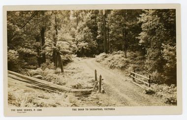 Mt Dandenong & District Historical Society Inc.
Photograph, The Road to Sassafras. Victoria
Rose Series postcard # P. 1588 showing a view of the road to Sassafras pre WW1.Sepia Coloured Rose Series post card P.1588 showing a stretch of unmade road passing over a simple bridge on the road to sassafras.On Front: THE ROSE SERIES, P. 1588 THE ROAD TO SASSAFRAS, VICTORIArose series, postcard, sassafras, road -
 Glenelg Shire Council Cultural Collection
Photograph - Photograph - Island Park Casterton, c. 1963
Sourced from Casterton Town Hall (Former Shire of Glenelg)Black and white photo, Island Park oval, Casterton, showing cycle track inside fence.Back: 'Island Park Oval. Cycle track shows inside fence', handwritten in green biro -
Glen Eira Historical Society
Article - Glenhuntly Athletic Club
... Corner North and Murrumbeena Roads, Murrumbeena, Victoria ...Correspondence received from Victorian Athletic Association with regard to assistance given by the city of Caulfield for Victorian road running championships at Caulfield Racecourse 1987, dated 16/06/1987 An article from the Caulfield /Port Phillip Leader on Sean Wroe’s participation in the Melbourne track classic, dated 01/03/2011 An article from the Caulfield /Port Phillip Leader on the success of Glen Huntly Athletic Club at the Victorian Youth Championship , dated 08/03/2011 An article from the Caulfield /Port Phillip Leader on Glen Huntly Athletic Club’s ‘participation in the Australian 20km walk championship and the Australian Athletics tour, dated 08/03/2011 An article from the Caulfield / Port Phillip Leader on Glen Huntly Athletic Club's’ win of the HH Hunter Shield, dated ,15.03.2011 An article from the Caulfield / Port Phillip Leader on Glen Huntly Athletic Club’s wins at the Australian Junior Athletics Championship, dated 22.03.2011 An article from the Caulfield/ Port Phillip Leader on Sean Wroe from the Glen Huntly Athletic’s Club participation in the Australian Athletic’s Championship and World championship, dated 12.04.2011 An article from the Caulfield/ Port Phillip Leader on Glen Huntly Athletic’s Club’s participation in the Victorian cross country r5elay Championship, dated 17.05.2011 An article from the Caulfield /Port Phillip Leader on Sean Wroe and Kelly Hetherington representing Glen Huntly Athletic Club at the World University games in China, dated 09.08.2011 An article from the Caulfield/ Port Phillip Leader on the success of the Women from Glen Huntly Athletic Club at the Athletics Victoria road relay Championship, dated 16.08.2011 An article from the Caulfield/ Port Phillip Leader on the Sean Wroe, from the Glen Huntly Athletic Club ,bronze medal win at the World university Games in China, dated 30.08.2011 An article from the Caulfield/Port Phillip Leader on Glen Huntly Athletic Club’s participation in the Athletics Victoria summer shield series dated 25. 10.2011 An article from the Caulfield /Port Phillip Leader on the success of Glen Huntly Athletic Club at round 2 of the Summer Shield series , dated 1.11.2011 An article from the Caulfield/ Port Phillip Leader on the placing of the Glen Huntly Athletic Club at round 3 of the Summer Shield series , dated 8.11.2011 An article from the Caulfield/ Port Phillip Leader on the success of the Glen Huntly Athletic Club at round 3 of the summer shield series ,dated 22.11.2011victorian athletic association, city of caulfield, caulfield, caulfield south, glen huntly athletic club, campbell jack cr, caulfield racecourse, aylen d.r, melvin david, onley peter, etherington chris, victorian olympic council inc, sports federation of victoria inc, australian athletic union, victorian road running championship, mason gregor, clubs, associations, sports, recreations, competitions, sporting clubs, leisure, cultural events, cultural associations, running, athletics, victorian open, awd track and field championship, hh hunter shield, wroe sean, sports grounds, ovals, parks, reserves, melbourne track classic, victorian track and field championship, australian athletics, australian junior athletics championship little athletics, state track and field championship, australian athletics championship, world championship, victorian cross country relay championship, the hunters, the lady hunters, sports people, the world university games, athletics victoria, road relay championship australian commonwealth games association athletics victoria, victorian youth championship, summer shield series, entertainment, carter matt, krawitz shaun, nelson jordan, dillon hunter jonathan, cowley rhydian, satupai margaret, mulhall kim, clarken lielani, lappin. jake gallagher jessica, kauffman jessica, hoilten ruby, edwards julia, thompson noni, rarasinghe kulan, fountain erica, seibold- crosbie kate, offereins ben, moore kevin, milburn joel, steffensen john, rouge-serret aaron, hetherington kelly, kingdom trychelle, ryde michael, flook, isabella, debonolt kayla, nakase taishi, lund sarah, cuttler claire, santa jason, alves francesca, lagreca marcus, nomikoudis maria, brammer ally, kolokythas keelan, clarksen oisin, hibbert chris, green ellia, palackic ian, nakase kaori, edwards nicholas, globan like, mc lean emily, anthony nicola, robertson adelaide, lang chynea, mac lean tom, hart darren, kanneh vandy, wiseman angus, thompson riley, montag jemima, watson sasha, mouratch daniel, montag piper, brammer bridget, mc donald geogie, mckenzie charlotte, kelaart oliver davis nicola, katsanevakis katherine, fyfe karinna, dick kylie, thompson anna, dennett belinda, corcoran bridget, beech georgina, fletcher robyn, grimes lesley, nakase paulg, suteau frederic, bowly simon, bott justin, radose vic nenad, lelehan shaun, weatherall bridget, cook meredith, higham cassie, bennett belinda, macknamara peter, harvey mattew, miller brendan, golonka kurt, robertson hamish, byrne angela, soderstrom roland, mcinnes simone, lang beau, hodgens ben, shephert jarrod, crane jordon, beadman mackenzie, russo antonio, doran anthony, hanrahan justin, cohen justin, allen linda, austin juliet, lang beau, little william, arthur mikhalla, roberts amy rose, beraun patrick, carothers callum, byrne shane, papanikolaou joshua, cater adam, rainey helen, hutton philip, zeleznikow john, glico tim, hamilton lucy, ross anna, ione casey, phelan leigh, russo anthony, hogben lachlan, vandwater melissa, gray molly, cleary sarah, parrish katy, comport michael, parkinson nick, byrne christine, wood courtenay, macknamara kellie, axford tyse, zele znioko eva, beguely patricktelfer olivia, nomikoudis john, kelaart isabel, miller aaron, oglesby david, llewelyn hannah, hamilton daniel, holmstorm maddison, winter chris, lang jeffrey, caulfield/port phillip leader -
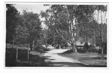
 Ringwood and District Historical Society
Photograph, View of Ringwood in 1912 taken from Loughnan's Hill
Black and white photograph looking across valley with small settlement. Mountains in background. (2 postcard copies and 2 enlargements). House in right foreground is in what is known now as Wildwood Grove. The dirt track above is Ringwood St. Field above is the football field with diagonal track coming out at Melbourne Street, later Eastland shopping complex. House on left is in Adelaide Street. Warrandyte Road is above it."Typed on back of one enlargement, "Copied from a postcard mailed in Ringwood, 1912, copied 1959. House in right foreground is in what is known now as Wildwood Grove. The dirt track above is Ringwood St. Field above is the present football field with diagonal track coming out at Melbourne Street. House on left is in Adelaide Street. Warrandyte Road is above it." House bottom RH side was still there in 1970 in Wildwood Grove (off Ringwood St). Ringwood Street lower centre to RH side. Field above Ringwood Street is the football field with diag. walk coming out at Melbourne Street. House on LH side in Adelaide Street. Warrandyte above it. Steam at LH from Bently's Steam Joinery at corner Main Street and Warrandyte Road. -
 Phillip Island and District Historical Society Inc.
Photograph, Lovers Walk, Cowes, Phillip Island, ?
Lovers Walk extending from the east end of The Esplanade, Cowes, adjacent to the beach, towards Rose Street. Man walking away on track. A wooden railing extending from wooden bridge in foreground to diminishing track and back drop of trees.Lovers Walk track, wooden bridge in foregroundlocal history, photographs, lovers walk, cowes, black & white photograph, noel ayton collection, bruce bennett -
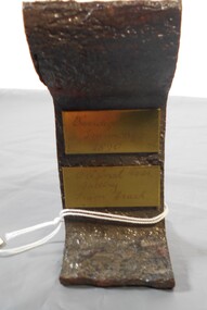
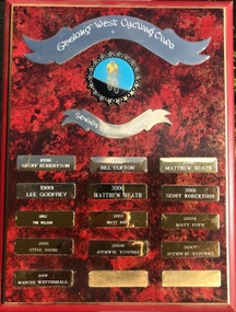 Geelong Cycling Club
Shield, 1996
This shield records the cyclists who were high achievers in track cycling in the Geelong region at this time.This shield has an important place in the history of men in track cycling in Geelong.A mahogany coloured rectangular wooden shield with brass plated plaques containing inscriptions of winners of the senior men's track aggregate during the years 1996-2008. There is an emblem of a cyclist and two banners at the top centre of the shield. "Geelong West Cycling Club/Senior Track Aggregate/1996/Geoff Robertson/1997/Bill Clifton/1998/Matthew Heath/1999/Lee Godfrey/2000/Matthew Heath/2001/Geoff Robertson/2002/Tim Wilson/2003/Matt Pope/2004/Matt Pope/2005/Steve Young/2006/Steve Young/2007/Steve Young/2008/Marcus Mettenhall"geelong west cycling club; senior track aggregate; geoff robertson; bill clifton; matthew heath; lee godfrey; matthew heath; geoff robertson; tim wilson; matt pope; steve young; marcus mettenhall; -
Stawell Historical Society Inc
Map, R.O. Robson - Authorised Surveyor, Road from Glenorchy to near Geary's Selection Callawaddy 1880, 29.04.1880
Survey for Road CreationCloth Backed Map. Plan of Road.Parishes of Richella & Callawadda. County of Borong. Plan of Road. R.O. Robson Authorised Surveyor Stawell 29.04.80 -
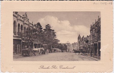 Camberwell Historical Society
Postcard - Photo postcard, Postcard of Bourke Road, Camberwell, Unknown date but postcard probably dated circa 1900 - definitely pre 1913 because in that year gas lamps were removed from main roads, intersections, also street trees in Burke Road. Also no cars are visible on the street, only horses and carriages. In March 1894 the first streets in the central city of Melbourne were lit with electricity
... main roads, intersections, also street trees in Burke Road ...Undated photograph on postcard depicting horses and carts with gas lamp in the distance on Bourke Road, Camberwell. Front of postcard: 'Bourke Road, Camberwell' Back of postcard: 'Post Card' 'This side for correspondence' 'This side for address' 'Stamp here' 'Printed in Germany.' Handwritten notes '22649 $20'camberwell, bourke road -
 Orbost & District Historical Society
black and white photograph, 1913
This photograph shows Country Roads Board men clearing a bush track at Hospital Creek. Their vehicle was bogged. The y Roads Board was formed in 1913 1910 it had become apparent that there was a need for a central roads authority to take over responsibility from the Board of Lands and Works for the care and management of the main roads of the state of Victoria. Because there was no consistent and systematic policy for road maintenance Victorian roads were in a deplorable condition. At this time the use of the motor car accentuated the demands for better roads. As a result of these needs the Country Roads Act 1912 was proclaimed in 1913 providing for the establishment of the Country Roads Board as a central road authority with responsibility for those roads within the State considered to be main roads. the C.R.B. was responsible for the construction of roads and bridges including the Snowy River road bridges in Orbost.. This is a pictorial record of transport difficulties in East Gippsland in early 20th century.A large black / white photograph of three men clearing a bush track with a motor vehicle behind them.transport roads road-maintenance country-roads-board -
 Marysville & District Historical Society
Photograph (item) - Colour photograph, 2007
A colour photograph of the walking track which leads to Steavenson Falls after a snowfall.A colour photograph of the walking track which leads to Steavenson Falls after a snowfall. The Steavenson Falls are named after the Victorian Assistant Commissioner of Roads and Bridges, John Steavenson who arrived in Victoria in the early 1860s.2007/ Steavenson Fallssteavenson falls, waterfalls, marysville, victoria, snow, john steavenson -
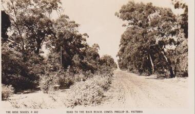 Phillip Island and District Historical Society Inc.
Photograph, Cowes, Phillip Island, C 1926
A dirt road - telegraph polesRoad to the Back Beach, Cowes, Phillip Island, Victoria. The Rose Series P662The Rose Series P662. Road to the Back Beach, Cowes, Phillip Is., Victorialocal history, postcards, cowes back beach, dirt road, sepia photograph, ian reiher, rural, cowes, phillip island -
Glen Eira Historical Society
Document - Nithsdale
... Corner Kambrook and Glen Eira Roads, Caulfield North ...One document about this property: 1/Photocopy of Caulfield Conservation Study by Andrew Ward dated August 1994 - gives architectural features of 133 Kambrook Road, and notes that original 1858 house is still visible. The article also mentions that further additions to the house from 1860 to 1925 eventually upgraded the home to mansion status. The history lists all owner/tenants from 1858 to 1925. Includes two poortly reproduced photos.kambrook road, 'nithsdale', house names, mansions, italianate style, architectural styles, crouch thomas, caulfield north, chambers j., glen eira road, stables, ironmongers, maxwell charles, ogilby james, bambra road, hobbys william, smith dudley, grazier, ward andrew, millers, brockhoff adolph -
 Mt Dandenong & District Historical Society Inc.
Photograph, The Mt Dandenong Road c1930, c1930
Formed, unmade road. Possibly between Silvandale Store and FiveWays, Kalorama. Copy of Rose Series postcard # 310. (2 copies)Black and white photograph showing a road passing through trees. THE ROSE SERIES P. 310 THE MT DANDENONG ROAD VICfiveways, rose series, mt dandenong road -
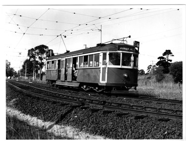
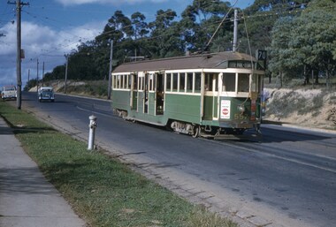 Melbourne Tram Museum
Slide, John Webster, 28/05/1960 12:00:00 AM
Colour slide, Kodak, white cardboard of Tram 557 waiting on passing loop, Riversdale Road, Wattle Park, outbound to Wattle Park, Elgar Road, route 70/ Has adverts for Coca Cola, 3AW. Also has an Auxiliary board - Football? There is a fire hydrant in the view and the tram stop sign. Slide dated 28-5-1960.Hand writing on rear in ink "28-5-60- Track - Tram 557 waiting on passing loop, Riversdale Road, Wattle Park, Melbourne Vic"trams, tramways, w2 class, wattle park, riversdale rd, route 70, tram 557 -
 Melbourne Tram Museum
Photograph - Black & White Photograph/s, early 1950's?
Black and white photograph of W5 No. 779 inbound to the City and Domain Road on route 56, on the open ballasted track just before passing under the railway line at the Zoo gardens area. Shows the open doors with the bars down. Photo of the tram slightly out of focus. Taken early 1950's by an unknown photographer. In the overhead shows a sign black cross in a circular disc and behind the tram a incandescent light suspended in the middle of the overhead. The photo shows the construction of the track at this location, dog spiked sleepers, the rail supports for the inner check rail. In the background behind the tram is the lever for the points of the crossover.On the rear in red ink "Melbourne tram shows use of Off-street tracks in an outer suburb"trams, tramways, zoo tram, reserved track, track construction, w5 class -
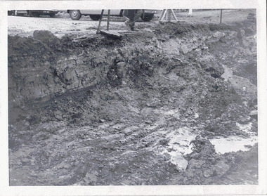 Kew Historical Society Inc
Photograph - Road works in Studley Park Road, 1968
One of a series of photographs donated by the City Engineer of the former City of Kew, relating to road works and rubbish removal.One of a series of photographs of core local government services as practised by the City of Kew. The photographs are an accurate record of council works of the period.Original black and white photographic positive of excavations in the roadway of Studley Park Road in 1968."STUDLEY PARK ROAD AT CARSON STREET / 1968/9"city of kew, local government -- city of kew, council works, street maintenance -
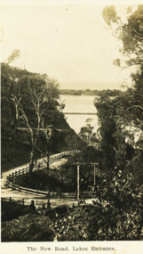 Lakes Entrance Historical Society
Postcard - The New Road Lakes Entrance, 1922 c
Also three postcards showing different views of the road around Jemmys Point 05281.1, .2 and .3Black and white postcard showing view of new alignment of the Princes Highway on Jemmys Point and part of the original high steep road approaching Lakes Entrance VictoriaThe New Road Lakes Entrance waterways, roads and streets -
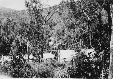 Halls Gap & Grampians Historical Society
Photograph - Sepia, C 1920s
Photo is said to be that of roadmakers camp for workers on the construction of the Mt Victory RoadPhoto shows a number of tents in bush land, said to be road makers campRoad makers camp Mt Victory Rd during the dat 1920sstructures, tents, access routes, road building -
 Kiewa Valley Historical Society
Photo - Bogong Township, September 1953
In 1940 Field Headquarters for the Kiewa Scheme were established at Bogong with office, workshop facilities and accommodation for workmen, staff and some families constructed. (There had been a 'tent camp' on this site in 1939 but was destroyed by bushfires) Construction of accommodation continued until 1947. A total of 40 houses plus a hostel for single staff, post office, police station, medical centre and primary school all with water and sewerage and electricity supply. The staff hostel was known as Kiewa House and is now occupied by the Education Department. Lake Guy was named after Mr. L.T. Guy who was the Resident Engineer in charge of construction work and associated activities on the Kiewa area. He held this position from 1939 to November 1946 when he was transferred to Head Office. The Bogong Township was developed firstly as an accommodation centre (base camp) for construction workers employed under the Kiewa Hydroelectric Scheme. Due to the influx of European workers into the Township the beautification of the immediate surrounds (gardens etc.) had a distinct European flavour. This environment has been very beneficial for tourism in later years. At the completion of the scheme, in the 1960's, the village was opened to public/tourism use. Strict environmental control has not allowed for any extensive redevelopment in tourist accommodation and basically restricted it to the accommodation initially built for the construction workers. Activities such a bike riding, snow skiing, restricted horse riding and bush walking on the Alpine plains and mountains are now a viable part of the Kiewa Valley Tourist Industry. The lake is one of the many water storage reservoirs used to supply the power stations their main power to run the huge turbines generating the final product, electricityBlack and white photograph of Bogong Township taken from Little Arthur fire track. September 1953Faded handwritten inscription on back - Bogong Township taken from Little Arthur fire track. Sept 1953bogong village, secv -
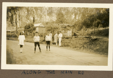 Mt Dandenong & District Historical Society Inc.
Photograph
The photograph is from the album of Ivy Child. The road featured called the 'Main Road' is what we know know as Mt Dandenong Tourist Road. It has been made but not tarred. The identity of the people is unknown. Ivy May Child (1910 – 1989) was the daughter of Arthur Edward (Ted) Child (1878 – 1964) and Ethel May Madden (1888 – 1970). Ted Child was the son of Matthew Francis Child (1839 – 1933) and Martha Jeeves (1857 – 1926). He was the grandson of one of the early pioneers Francis Child. Ivy grew up on the family property on Childs Road and took many photographs. Most of these are glued into her photo album. The album covered the years from c1927 – 1932. Ivy married Henry William Burgess (1906 – 1968) in 1944. The photographs remain in their original state in the album with individual copies made. Sepia coloured photograph showing a stretch of road with two young boys and a girl standing in the middle. Behind them, standing on the edge of the road are two women and a man. Behind them is a wire and post fence with wooden gate and a shed. Bush is visible in the background.Handwritten below the photograph in the album: ALONG THE MAIN ROADivy child, main road, mt dandenong tourist road, tourist road, kalorama -
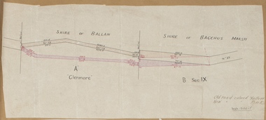 Bacchus Marsh & District Historical Society
Map, Road plan deviation near Glenmore
This plan shows a proposed deviation in the road near Glenmore. This is likely to have been the Bacchus Marsh to Ballan road. The precise date of the plan has not been established. Proposed deviations to the road near Glenmore appear in reports in the Bacchus Marsh Express newspaper through many decades, especially in the 1870s and 1880s. Glenmore is located 19 kilometers west of Bacchus Marsh.A single page paper map showing a plan for a road deviation near Glenmore Station. Scale 5 chains to 1 inch. Date of production unknown. Circa 1860s-1890s. The map is pasted into a bound volume containing 76 maps or plans in total. High resolution digital image stored on BMDHS computer network. Old road colored Yellow, New road colored Pinkroad plans, road construction, glenmore victoria maps -
 Otway Districts Historical Society
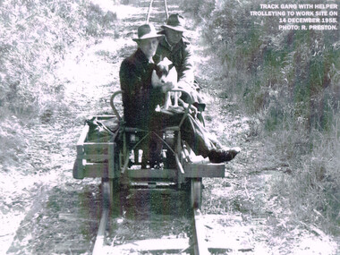
Photograph, R. Preston, Trolleying to work site, 1955, 14 December 1955
At its peak the Beech Forest railway employed more than 21 staff between Colac and Crowes. Gangers (men in charge of the track gangs) tended to be promoted into the Otways but many of their subordinate repairers were local recruits. A few of the men who worked in the original construction gangs of 1900-1902 remained and obtained positions in the track gangs along the line. The track was maintained by seven three-man gangs based at Colac, Barongarook, Gellibrand, Banool, Beech Forest (2), and Lavers Hill. However, track gangs lessened as the line shortened. After 1954, the sole surviving track gang, in charge of Paddy Balcombe, stayed until the line closed.A railway track gang, with helper, trolleying to a work site, on 14 December, 1955.beech forest; railways; track gang; -
 Bendigo Historical Society Inc.
Ephemera - Cross section of tram track Bendigo 1890
BHS Collectionhistoric Bendigo tram track profile 1890 from original Tram depot in Mollison StreetOriginal No. 29 Battery Tram Track, Bendigo Tramways 1890. Dug up from Mollison Street, Bendigo, where the Tram Depot used to be sited. Brass tags note Bendigo Tramways 1890 and Original No. 29 Battery Tram Tracktramways bendigo, tram track profile 1890 -
 Surrey Hills Historical Society Collection
Photograph, Entrance to Wattle Park from Riversdale Road, 1912-1914
Information provided by Stan Smith: Riversdale Road looking east 1912-1914. Wattle Park, then a farm is on the right. The near row of trees across the picture, indicates the driveway in Wattle Park. Wattle Park was then Fenwick's farm - or - Fennies to the local boys. Note: Riversdale Road becomes not much more than a track after passing the farm entrance.A dirt road in the lower left corner of the photograph is bounded by a post and rail fence. Two cyclists are on the road. "Wattle Park" is written to the right side of the road.wattle park, 1912, farms, 1914, fenwicks farm, fennies, fences, trees, roads and streets, riversdale road, pine trees, gum trees, cyclists -
 Ballarat Tramway Museum
Photograph - Colour Photograph/s, Austin Brehaut, 15/03/2003 12:00:00 AM
Colour photograph of tram 33 terminating at the north end of Gardens Loop, Wendouree Parade, the first service tram to do so on Sat. 15 March 2003. The service was terminated at this point for some 6 weeks while Wendouree Parade was resurfaced and other track work done. Shows the temporary terminal arrangements, and the earth cable installed to protect the work site on the section insulator and earth stake alongside the pole. Tram 33 has the Eureka roofing tiles and SEC Briquettes roof advertisements and Twin Lakes sign on the drivers dash panel. The destination shown is Gardens via Sturt St. West. Photo taken by Austin Brehaut and printed on Kodak paper.In black ink on the rear of the photo "1st car to use short-working during track and road repairs 15.3.03 / APB"btm, road works, gardens loop, wendouree parade, tram 33 -
![Construction of the electric tram line in Cotham Road [Kew]](/media/collectors/550653872162f11fb04854aa/items/662870846214a76cee3aecf0/item-media/662870de6214a76cee3af7de/item-fit-380x285.jpg) Kew Historical Society Inc
Kew Historical Society IncPhotograph - Construction of the electric tram line in Cotham Road [Kew], E.J. Dower, 1913
One of a small album of six photographs of the construction of the Cotham Road tramline in Kew, taken by Edgar James Dower in the second decade of the twentieth century. The reverse of each photo contains notes, written over time by the photographer, which are contained in the 'Inscriptions' field. Born and raised in Olinda, Dower's family later moved to Surrey Hills. He worked as an adult as a clerk in the city office of the Metropolitan Gas Company, and in his role as a 'collector', he was able to photograph scenes including the construction of tram and train lines and associated buildings in Kew, Hawthorn, Camberwell and Surrey Hills. Later he established a real estate agency with his brother - the E.J. Dower Real Estate Agency, Dandenong Office. The album as a whole can be viewed separately as the parent file.The image is an historically significant record of the development of transport infrastructure which was used to connect Victorians in the first two decades of the twentieth century. This development resulted from increases in population and the consequent extension of Melbourne's suburbs. The photographs in the album, as well as Dower's single photos mounted on card, individually and collectively richly detail the labour of workers and the tools and machinery used to create and extend Melbourne's tram and train networks in the years preceding and during World War 1.The first of six annotated photos in an album of photographs of the construction of the St Kilda to Kew electric tram line, taken in Cotham Road, Kew, by the amateur photographer, Edgar James Dower, in 1913. The album contains images detailing the preparation for the laying of the tracks plus work laying the line. The photographer notes on a number of the photos that te metal tracks were collected from the Hawthorn railway siding. The album, together with other phots by E.J. Dower has been made available by the owners for the Kew Historical Society to digitise and publish online and in print.Annotation verso: "1913 / Preparing for electric trams in Cotham Road Kew, looking west / Taken from corner of Burke Road by E.J. Dower / The metal was brought by horse and drays, from Hawthorn rail-way siding".keywords, theme -- connecting victorians by transport and communications, theme -- travelling by tram, photographers -- edgar james dower, cotham road -- kew (vic.) -
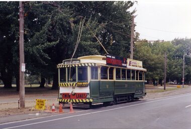
 Melbourne Tram Museum
Pamphlet - Metro Tunnel - Anzac Station tram corridor works, Rail Projects Victoria, 11/2022
Provides information about the works planned to realign tram tracks at the Metro Tunnel Anzac station, following the completion of the surface works. Gives timing, tram routes affected, plans of the proposals, contact details. All St Kilda Road routes would be affected from 27/11/2022 to 17/12/2022, tram stops would be closed, bus replacement services. includes works to remove the Glenhuntly Road level crossing at Glenhuntly Station. Yields information about the trackworks for the future Anzac Station interchange and St Kilda Road services.Set of two documents issued by Rail Projects Victoria (Metro Tunnel) and Yarra Trams with regard to the reallignment of tram tracks at Anzac Station Nov. 2022 1 - Metro Tunnel - Works proposed, maps - 6 A4 pages 2 - Yarra Trams - Service Changes St Kilda Road works - 4 A4 pages.anzac station, metro tunnel, tramways, st kilda road, domain road, domain interchange, park street, track work, tram tracks, glenhuntly road, glenhuntly station, level crossings -
 Greensborough Historical Society
Photograph, Greenhills, 1950c
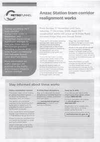
This is a photograph of a small child (possibly Sue Darling) on a bush track identified as Albion Crescent in the Greenhills estate, Greensborough.This photograph shows the rural nature of this area of Greensborough in the mid 20th century, which is now suburban.Black and white photograph of a small girl on a country track.In pencil on back of photograph: "Albion Cres posssibly Sue Darling"greenhills, albion crescent, greensborough, sue darling -
 Mt Dandenong & District Historical Society Inc.
Photograph, The Wagon Road, c1970s
The old Wagon Road built 1876-1878. This photograph has a detailed inscription on the back handwritten by John Lundy-Clarke in 1974.The Wagon Road. Built 1876 – 8. The first settler’s road in the Ranges as apart from Dray Tracks. Was built through Jeeves Selection, Crown Allotment “C” named “Jeeves saddle” and removed the monopoly held over travel through the Gap. jeeves saddle, kalorama, road, wagon road, john lundy-clarke