Showing 11143 items
matching line
-
 Lakes Entrance Historical Society
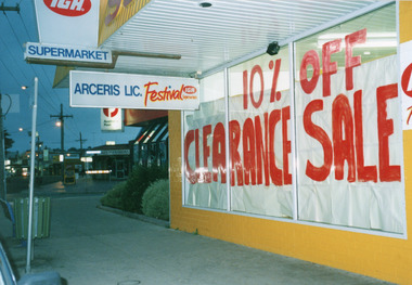
Photograph - Arceris Supermarket, 1995
Date made 11 May 1995Colour photograph of the front windows of Arceris Supermarket, fronting Esplanade, after closing down after almost twenty years trading, windows lined with white paper. Also in view Post Office, Lakes Fashions, and Glenara Motel. Lakes Entrance Victoriaretail trade, local history -
 Whitehorse Historical Society Inc.
Artwork, other - Ink Line Drawing, Margaret Picken, 63 Vicki St., Forest Hill, 1998
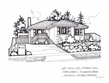
A property illustration by Margaret Picken Commissioned by the real estate agency Hocking Stuart Blackburn for the purpose of advertising 63 Vicki St., Forest Hill This property has be subdivided into two house since being sold in 2002. Made by using Rotring ‘Rapidigraph’ drafting pens with Rotring ink on Rapidigraph polyester drafting film, double matte. Trained as a cartographic draftsman within the mining industry, Margaret Picken is an artist who worked producing property illustrations for real estate agencies in eastern suburbs of Victoria from 1983-2005. Retiring from the industry as technological changes favored coloured photography over illustrations, and commissioning companies over sole contractors.This artwork is of Historical Significance as a record of local domestic architecture.A black ink line drawing on drafters film by Margaret Picken, of 63 Vicki St., Forest Hill depicting a single story brick house with steps up the concealed doorway. On the left a driveway leads to a gated garage, on the right in the foreground is a front garden.63 Vicki St., Forest Hill Margaret Picken © 2002 Hocking Stuart B/Burnwhitehorse historical society, schwerkolt cottage, housing, architecture, margaret picken, house, garden, forest hill, real estate -
 Whitehorse Historical Society Inc.
Artwork, other - Ink Line Drawing, Margaret Picken, 15 Donald St., Burwood, 1995
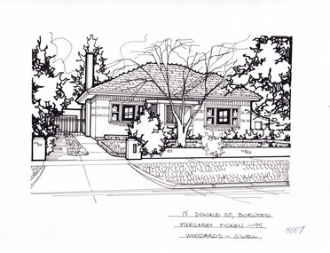
A property illustration by Margaret Picken Commissioned by the real estate agency Woodards Camberwell for the purpose of advertising 15 Donald St., Burwood in 1995. Made by using Rotring ‘Rapidigraph’ drafting pens with Rotring ink on Rapidigraph polyester drafting film, double matte. This property is listed as having sold for $190,00 in 1995 Trained as a cartographic draftsman within the mining industry, Margaret Picken is an artist who worked producing property illustrations for real estate agencies in eastern suburbs of Victoria from 1983-2005. Retiring from the industry as technological changes favored coloured photography over illustrations, and commissioning companies over sole contractors.This artwork is of Historical Significance as a record of local domestic architecture.A black ink line drawing on drafters film by Margaret Picken, of 15 Donald St., Burwood. A two story weatherboard house set back from a picket fence and and open gate on the right for the driveway. There are two hole punches near the upper edge.15 Donald St., Burwood Margaret Picken - 95 Woodards - c'well whitehorse historical society, schwerkolt cottage, housing, architecture, margaret picken, burwood, house, garden -
 Melbourne Tram Museum
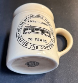
Domestic object - China cup or mug, Dynamo House, South Melbourne Depot 70 years, 1995
Made by Dynamo House for the South Melbourne Depot staff to celebrate their 70th anniversary. The depot was closed and relocated to Southbank during March 1997.Demonstrates a domestic item made to celebrate an event.Cream coloured china cup or mug with handle, shaped lip with a line drawing of wide body W class car with the words "Serving the Community - South Melbourne Tram Depot 75 years 1925 - 1995". Made by Dynamo House with a phone number.tramways, south melbourne depot, 70th anniversary, celebrations -
 Bendigo Historical Society Inc.
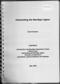
Booklet - David Dunstan - Interpreting the Bendigo Region
Compilation of natural, historic and commercial attractions of the whole Bendigo RegionDavid Dunstan - Interpreting the Bendigo Region. The Bendigo Interpretive Centre will combine Technoloy and traditional display techniques with user-friendly on-line tourist information to provide easy access to information on the rich array of natural, historic and commercial attractions of the whole Bendigo Region.natural, historic and commercial attractions of the whole bendigo region -
 Bendigo Military Museum
Award - MEDAL, POLISH, 1998
Medal issued by Polish Government to all forces who served in Tobruk, WW11, with Polish forces. This medal was issued to Frederick Lloyd CARLETON VX33476, 2/23rd Batt AIF. Refer Cat No 142.7 (medals) for his service history..1) Polish medal connected to Tobruk, has white eagle on front, four-pointed shape; on blue, black, green, white & red cloth ribbon, metal bar at top. .2) Red leatherette case lined with red velvet and white satin. In Polish, on rear of medal, "1939 Polskie Sily Zbrojne na. Zachoozie 1945" (Polish Armed Forces in the West) In relief on front of ribbon - "Tobruk" White eagle on front is national symbol of Polandnumismatics, medals, military, containers -
 Orbost & District Historical Society
black and white photographs, 20th century
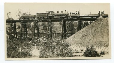
These photographs are probably of bridges on the East Gippsland railway line. 3162.2 is possibly Hospital Creek and 3162.3 possibly Burn Road Newmerella. The Orbost-Bairnsdale railway initially played a crucial role in developing agricultural industries in Gippsland as well as tourism. It opened in 1916 and operated until 1987, principally carrying timber and farming produce. In the early days of the railway's operation dedicated passenger trains ran but these ceased by the 1930s. The line was completely closed to freightage in 1987.The track infrastructure was dismantled in 1994 and has been redeveloped as the East Gippsland Rail Trail.These photographs are associated with the history of the Orbost-Bairnsdale railway line and therefore reflects the role that the rail line played in the social and economic history of Orbost. Three black / white photographs of railway bridges. 3162.1 has a steam train on the bridge. 3162.3 shows three men on the right working at clearing vegetation. 3162.3 has been taken from a height.orbost-bairnsdale-railway east-gippsland-railway bridges-railway -
 Orbost & District Historical Society
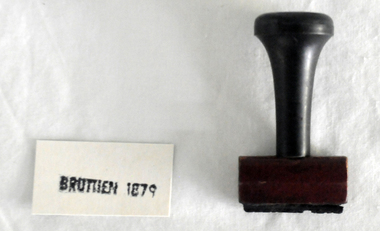
stamp, C 1960's
This stamp was used at the Orbost Railway Station. The Bairnsdale-Orbost railway was opened in 1916 to serve the agricultural and timber industry. Because of the decline in traffic and heavy operating costs, the line was finally closed in August, 1987. Orbost Railway Station was opened on Monday 10 April 1916 as the terminus of the Orbost railway line, and closed in 1987. The station was located on the west side of the Snowy River despite the town of Orbost being on the east side of the river, in order to save on the costs of a bridge over the river, which at the time had highly variable levels This item is associated with the history of the Orbost-Bairnsdale railway line and therefore reflects the role that the rail line played in the social and economic history of Orbost.A stamp with a black plastic handle. The bottom is wood and the stamp rubber. It has "BRUTHEN 1879" on it."BRUTHEN 1879"orbost-railway-station -
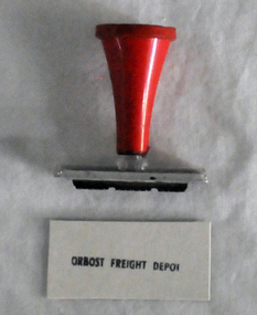 Orbost & District Historical Society
stamp, 1970's
This stamp was used at the Orbost Railway Station. The Bairnsdale-Orbost railway was opened in 1916 to serve the agricultural and timber industry. Because of the decline in traffic and heavy operating costs, the line was finally closed in August, 1987. Orbost Railway Station was opened on Monday 10 April 1916 as the terminus of the Orbost railway line, and closed in 1987. The station was located on the west side of the Snowy River despite the town of Orbost being on the east side of the river, in order to save on the costs of a bridge over the river, which at the time had highly variable levels, This item is associated with the history of the Orbost-Bairnsdale railway line and therefore reflects the role that the rail line played in the social and economic history of Orbost.A stamp with a red plastic handle and a white stamping face - "ORBOST FREIGHT DEPOT".VUESTAMP AUSTRALIAorbost-railway -
 Hume City Civic Collection
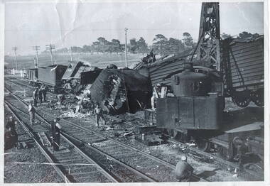
Photograph, Rail accident, 1952
The train smash occurred in Sunbury between the Station Street level rail crossing and Sunbury Station on February 6th 1952 at around 10pm. The goods train was being pulled by the green locomotive, which was used to take the Jubilee train throughout Victoria in 1951, to acknowledge 125 of European settlement in Victoria, ran into the back of another stationary goods train on the rail line. The guard, A.C Read, in the stationary goods train was killed. P J Mcwhirter, the guard in the other train was injured. The tree lined street in the background is Horne Street.This smash was one of a number that have happened along the Sunbury rail line and in the vicinity of Sunbury Station over the years.A black and white photograph with a white border of a train smash which wrecked a steam engine and carriages. Workmen are on the tracks surveying the wreckage. A rail crossing is in the background.jubilee train, train crashes, station street, sunbury railway station, a c read, p j mcwhirter -
 Wodonga & District Historical Society Inc
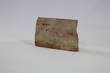
Functional object - Wodonga Station Platform Brick
The Wodonga rail line and railway station opened in November 1873 when the section of the line from Wangaratta was completed. The expansion of the railways to the northeast of Victoria occurred after the Victorian Government took over the railways in 1867 and the trains serviced large towns such as Seymour, Wangaratta and Wodonga, as well as smaller towns along the way. The original Wodonga Station, located in the middle of the city, was closed on 9 November 2008 as part of the Wodonga rail bypass project. The station platform was largely removed and the area has been redeveloped as part of the Junction precinct.This brick has local and state historical significance as the railways played a critical part in opening up the interior of Australia for commerce, transportation and settlement. It enabled Wodonga to develop as an important centre for social and commercial purposes.An old traditional brick with some joining mortar / concrete still attached. The brick formed part of the platform at the original Wodonga Railway Station prior to its demolition as part of the Wodonga bypass development.wodonga, railways, railway bypass, northeast victoria, vline -
 Wodonga & District Historical Society Inc
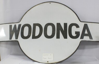
Sign - Wodonga Railway Station Sign
The Wodonga rail line and railway station opened in November 1873 when the section of the line from Wangaratta was completed. The expansion of the railways to the northeast of Victoria occurred after the Victorian Government took over the railways in 1867 and the trains serviced large towns such as Seymour, Wangaratta and Wodonga, as well as smaller towns along the way. The original Wodonga Station, located in the middle of the city, was closed on 9 November 2008 as part of the Wodonga rail bypass project. The station platform was largely removed and the area has been redeveloped as part of the Junction precinct.This sign has local and state historical significance as the railways played a critical part in opening up the interior of Australia for commerce, transportation and settlement. It enabled Wodonga to develop as an important centre for social and commercial purposes.A metal railway station platform sign, Wodonga is painted in black in the centre circle against an oblong cross piece"WODONGA"railways, wodonga railway station, victoria railways, wodonga -
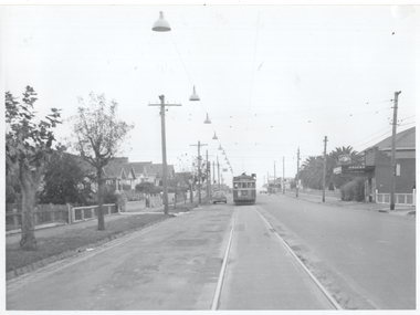 Melbourne Tram Museum
Photograph - Overhead Track lighting Nicholson St Coburg, Melbourne & Metropolitan Tramways Board (MMTB), 1960
Photo shows extensive track lights on the left side of the single-track Nicholson St East Coburg tram line with W2 class tram 473? inbound on route 1 just to the north of Grant St. This section of track was considered dangerous and to alleviate the problem of inbound or southbound tramcars not being visible well in advance to northbound motorists, the MMTB installed the track lights. The Chief Engineer at the 24/3/1960 meeting of the Board advised of the scheme that the track lights would be progressively switched on in advance of a southbound tram. The line was eventually duplicated in Dec. 1966.Yields information about a track lighting system to improve safety on a single line of tramway in East Coburg.Black and white photo, plain backnicholson st, single line, track lights, east coburg -
 Melbourne Tram Museum
Document, Victorian Parliament, "The Plenty Road, Preston, Tramway Extension Inquiry", 1967
Report by the Victorian Parliamentary Public Works Committee on "The Plenty Road, Preston, Tramway Extension Inquiry" - 1967. The inquiry examined the MMTB's proposal to extend the East Preston line 0.7miles or 1.3km. The Committee took evidence from the MMTB, bus operators, the Victorian Railways, residents, La Trobe University, Preston City Council and others. The Committee recommended against the proposal. The report lists those members of Parliament involved. The line was subsequently extended by 1.2 kilometres from Tyler Street to Boldrewood Parade during 1983 and subsequently to Bundoora. Demonstrates the method of holding parliamentary inquiries into new tram lines.Document - report - 9 pages stapled in top left-hand corner, printed with a spirit duplicator.tramways, parliament, new lines, east preston, inquiries, bundoora, plenty road -
 Bendigo Historical Society Inc.
Document - MINING REPORTS - LONDONDERRY SHAFT NO 249
' The old Londonderry Mine shaft has been capped after it opened in late July. The shaft was part of the Garden Gully Line, which held the greatest concentration of workings on the Bendigo Goldfield, has been capped after it opened in late July. The line starts under the Quarry Hill Golf Course and continues right through to Eaglehawk North'. (Source: Bendigo Advertiser, August 19, 2014.) Mine was located on Creek Street North, Bendigo. Central Deborah - Heritage Victoria Notes: Originally the Londonderry West shaft, now a mining museumHandwritten extracts by Albert Richardson (with typed copy of same) on the Londonderry Shaft, Bendigo in 1905, with reference to the brick dam being constructed.gold, mining reports, mining reports, londonderry shaft no 249, w westhead -
Surrey Hills Historical Society Collection
Work on paper (collection) - Vertical file of information related to Chatham Railway Station
-
 Bendigo Historical Society Inc.
Document - Hustlers, Sheepshead and Deborah lines of reef
Albert Richardson was a mining historian who wrote widely on the mines of the Bendigo Goldfield. The park opposite the Goldmines Hotel in Marong Road, is named in his honour. Five page document, hand written by Albert Richardson on lined foolscap and edited with cross-outs and insertions, . The mines along the Hustlers line of reef and the Sheepshead line of reef are described. Mines listed on Hustlers line of reef: Fortuna Hustlers (1888 - 1913), shaft 2,240 feet at rear of Buckell and Jeffrey's offices; Royal Hustlers Reserve No. 2 - two shafts 'City" 860 feet, now covered by R.S.L. building Pall Mall, steel poppet legs 60 ft high and 'Park Shaft" at rear of Camp Hill School, 1,775 feet, steel poppet legs 60 feet high; Hustlers Hill Group first worked by Jonathan Harris in 1853 and bounded by Valentine, Anderson and Ironbark Creek to the north and Milroy Street to the east, one of first areas worked for quartz reefing. It with Garden Gully line west and Victoria Hill Ironbark, formed by far the richest cross section of the Bendigo Goldfield. Great Extended Hustlers (1865-1921) close to intersection of Anderson Street and Hustlers Road, mullock heap against road and shored up around shaft, steel poppet legs now at Wattle Gully mine, Chewton, large winding machine, air compressor south of shaft and 36 head crushing battery. Hustlers Reef (Old Hustlers) and Hustlers Reef No. 1, two shafts, main 2,210 feet, about 220 yards east of Moran Street and against Fenton Street. , No. 1 shaft 1,140 feet and about 155 yards east of Moran Street. Lansell's Comet, Lightining Hill line, 2.100 feet, on Comet Hill approx 70 yards west of Holmes Road, near Comet Creek, steel poppet legs. United Hustlers and Redan (1876-1918), main Redan, 1,830 feet about 155 yards west of Sandhurst Roead, in line with Comet Hill State School, this hill known as Redan Hill. North, or New Hustlers, once known as Agnew Hustlers, wooden poppet legs, south side, Kneebone Street, Eaglehawk. Derby line, Johnson's No. 3, South Johnson's (east shaft of Collman and Tacchi) 439 feet on west wide of Woods Street, south of Wetherall Street. Paddy's Gully Line, south to north, some shafts - Lansell's 'Sandhurst" ('Needle") Eaglehawk Road shaft 2,425 feet, about 50 yards east of Needle Loops, a brick square sided chimney with Cleopatra Needle top. British American, 789 feet, just south of Holdsworth Road. Collman and Tacchi, main shaft 2,588 feet, 60 yards west of Eaglehawk Road, California Gully. Deborah Line of Reef, The Deborah (1932-1954) shaft 2.017 feet, west of Adams Road and south of Abel Street, Quarry Hill. North Deborah (1937 - 1954) shaft 1,151 feet, Breen Street, Quarry Hill, steel poppet legs. Central Deborah (1939-1954) shaft 1,347 feet Sheepshead line of reef, Lansell's South Red, White and Blue, shaft 2,124 feet, north east of Bellevue Road and 220 yards east of Adams Road. The New Red, White and Blue Consolidated (Big Blue) main shaft 2,416 feet. Lansell's Bendigo Battery 105 head, north of 'Big Blue" on his freehold lease, commenced crushing on 24th February 1895. After closing was erected as the Showground's Industrial Hall, July 1926. North Red, White and Blue, burnt down February 1926, new company 1934, closed 1938. Document is part of the Albert Richardson Collection of Bendigo mining history. bendigo, gold mining, deborah line of reef, sheepshead line of reef, hustlers line of reef, royal hustlers reserve mine, hustlers hill group of mines, great extended hustlers, hustlers reef no. 1, lightning hill line, old comet, collman and tacchi, lansell's comet, north deborah, central deborah, dhrrpdhrsf linr og trrg, new red, white and blue consolidated mine, big blue, lansell's bendigo battery, north red, white and blue mine, albert richardson collection -
 Mission to Seafarers Victoria
Leisure object - Baulk circle templates, Alcocks & Co, 1860-1960
These items are known as baulk circle templates. The larger one stamped Alcock & Co would have been made before 1888 (this is clear from the address). The middle one is more likely to have been made during the late 19th or early 20 century. The smaller on made of ply would have been made much later in the 20th century. The person maintaining the Billiard Table uses one of these templates to mark out a semi-circle on the table cloth in a particular position determined by the rules of the games of billiard and snooker. The semi-circle is known as the Baulk Circle. Together with a line across the table at the diameter of the semi-circle , known as the baulk line, the baulk circle plays a crucial part in these games. For example, the opening shot of each game is played from the baulk circle; in the game of billiard, if an opponent's ball crosses the baulk line, it may lead to his ball being “protected “during the next shot.A billiard room was a feature of all the Missions over the world.Set of 3 large semi circular wooden tools.pool, snooker, billiard, games, mission to seamen, mission to seafarers, alcocks, baulk line, baulk circle -
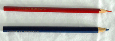 Orbost & District Historical Society
pencils, 1960's
These pencils were supplied to the Orbost railway Station office to be used for clerical work. They were used by Victor Smithers who was the Assistant Station Master at Orbost from 1957 - late 1960's. He was also a reliever until the 1970's after which he returned to Ormond Station on the Frankston line where he worked until his death in 1979. The Bairnsdale-Orbost railway was opened in 1916 to serve the agricultural and timber industry. Because of the decline in traffic and heavy operating costs, the line was finally closed in August, 1987. Orbost Railway Station was opened on Monday 10 April 1916 as the terminus of the Orbost railway line, and closed in 1987. The station was located on the west side of the Snowy River despite the town of Orbost being on the east side of the river, in order to save on the costs of a bridge over the river, which at the time had highly variable levels. This item is associated with the history of the Orbost-Bairnsdale railway line and therefore reflects the role that the rail line played in the social and economic history of Orbost.Two coloured pencils. 2580.1 is a hexagonal blue pencil and has "Wolff's Emperor MADE IN AUSTRALIA". 2580.2 is a round red pencil with "Wolff's Fintorex MADE IN AUSTRALIA coloured copying". Both have "VICTORIAN RAILWAYS" marked in gold lettering on the sides. orbost-railway-station smithers-victor -
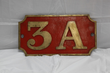 Puffing Billy Railway
Number Plate - 3A
Loco: 3A In service Monday, 4th June 1900 Livery Not painted Owner Puffing Billy Gauge 762 Status Stored 3A Built in 1900 and painted two-tone green, this locomotive was issued to the Upper Ferntree Gully to Gembrook line and was used in the line’s construction. Over the years, it saw service on the Colac to Crowes and Moe to Walhalla lines, but it saw more service on the Gembrook line than any other. It was withdrawn from service in 1955 at Upper Fern Tree Gully and sold in 1960 to the Lord Mayor’s Camp at Portsea where it remained on static display until 1977. From there it was eventually brought to Belgrave for eventual restoration. When restored, it will be returned, as far as possible to its original condition with wooden cow-catchers, original design side tanks, low bunker, no smoke-box ash chute, etc. It will also have its original colour scheme of two-tone green with white lining.Historic - Victorian Railways Locomotive Number Plate used on Steam Locomotive 3ALocomotive Number Plate from 3A made of cast metal & Brass3Apuffing billy, 3a, number plate -
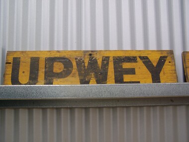 Puffing Billy Railway
Station Sign - Upwey
Upwey Station Sign; Upwey Railway Station is located on the Belgrave line in Victoria, Australia. This railway serves the Eastern region of Melbourne. Upwey Railway Station opened on the 3rd of June 1901. Upwey Railway Station has a crossing loop in the middle of a six kilometre section of single railway track between Ferntree Gully Railway Station and Belgrave Railway Station. The station was originally on the Upper Ferntree Gully to Gembrook narrow gauge line. The Upper Ferntree Gully to Gembrook Narrow Gauge railway line officially closed on the 30th of April 1954. It saw further use between 1955 and early 1958, when trains were operated by the Puffing Billy Preservation Society in co-operation with the Victorian Railways. The Upper Ferntree Gully to Belgrave section was converted to Broad Guage and re-opened on the 19th of February 1962. This station sign shown here was one of a number used on the Upwey Railway Station while it was Narrow Gauge. Historic - Victorian Railways Station sign used at Upwey StationUpwey wooden rectangle Station name sign pained yellow background with black font.Upweypuffing billy, station sign, upwey station, victorian railways -
 Ringwood and District Historical Society
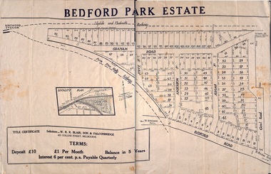
Pamphlet, Subdivisional Auction Sale, Bedford Park, Ringwood - 1924
Bedford Park subdivisional development did not eventuate. The land adjoining the railway line became parkland with provision for sporting facilities and the remainder was purchased by the Education Department as the site for Ringwood High School/Secondary College. Double sided bifolded auction sale advertisement including subdivision features and local facilitiesSubdivision plan includes Bedford Road, Graham Road, Joyce Street, Anderson Street, and Adams Street -
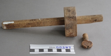 Upper Yarra Museum
Wooden Marking Gauge
Marking Gauges have been around for centuries in wood working shops, and is used to mark parallel lines on wood, either along the grain or across the grain, across the grain leaves a more jaggard line.This simple tool allowed Crafts or Trades people to consistently and accurately make parallel lines.Wooden Marker Part 1 - Marker Part 2 - Wooden screw Part 3 - Moving .....wood worker, carpenter, cabinet maker, gauge, mark, joints, mortice & tennon -
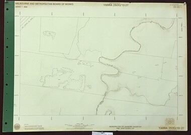 Greensborough Historical Society
Map, Melbourne and Metropolitan Board of Works. Survey Division, MMBW, Yarra 2500 / 13.27. Morang wetlands, 1977_09
Melbourne and Metropolitan Board of Works. Yarra 2500 [base map] 13.27. Morang wetlands. Municipality of Diamond Valley 257 and Whittlesea 239. Features include the Plenty River and SEC Transmission Line easement. MMBW Map in 1:2500 [scale] series. Cream parchment with green tape reinforcing on edges and punched holes on left edge.mmbw, melbourne and metropolitan board of works, shire of diamond valley, morang - maps -
 Greensborough Historical Society
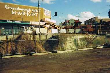
Photograph - Digital image, Para Road Greensborough from the Station, 1975_
Photograph of the intersection of Para Road and Main Street Greensborough circa 1975. Shows the Greensborough Valley Market on the corner and Greensborough Hotel in background. Taken from the Station, the train line can be seen in the foreground.Digital copy of colour photograph.greensborough valley market, greensborough station, para road, main street greensborough -
 Kiewa Valley Historical Society
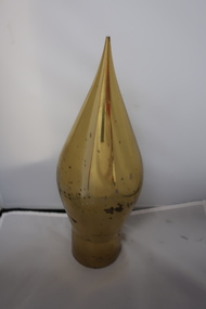
Pendulum weight
The pendulum weight was used to define a vertical line. Being so large and heavy it was possibly used from a tower or a dam. It was held by one end of a wire and measured any tilt of the structure in any direction.Possibly used on the Kiewa Hydro Electric Scheme during the construction of the dam walls and Electric Powerline towers.Cone shiny brass pendulum weight with cylinder shape that i hollow at one end. The hollow is threaded inside. The part that fits the hollow end is missing.pendulum weight, measurement, kiewa hydro electric scheme -
 Ringwood and District Historical Society
Plan - Sub-division, Bedford Park Estate, Ringwood, Victoria - 1924
Bedford Park subdivisional development did not eventuate. The land adjoining the railway line became parkland with provision for sporting facilities and the remainder was purchased by the Education Department as the site for Ringwood High School/Secondary College. Poster size land sale advertisement.Subdivision plan includes Bedford Road, Graham Road, Joyce Street, Anderson Street, and Adams Street. Solicitors - W.R.R. Blair, Son & Falconbridge, 405 Collins Street, Melbourne. -
 City of Moorabbin Historical Society (Operating the Box Cottage Museum)
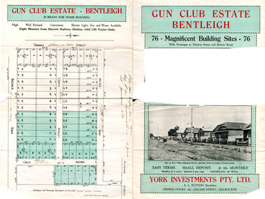
Flyer - Gun Club Estate, Highett, 1927
The train line from the city to Frankston was electrified in 1922 which intensified the sale in the municipality of Moorabbin, particularly land which was in the vicinity of the railway stations. York Investments Pty Ltd purchased the land in 1927.Example of the progress of the Municipality of MoorabbinAdvertising flyer for auction of real estate sales - plan of building blocks for saleGun Club Estate, Bentleigh 76 housing blocks - York Investments Pty Ltdthomas street, erica avenue, brewer road, grace street, victor road, melbourne gun club, benteligh, real estate -
Tatura Irrigation & Wartime Camps Museum
Book, Migrant ships to Australia and New Zealand 1900 - 1939, 2009
Story of ships that brought migrants to Australia and New Zealand 1900 - 1939. Including Whitestar, Orient, P&O line. Majority of passengers were from Great Britain but also from Germany and Italy. .Blue cover. Front cover painting of Zealandic by Stan Stefaniak. Back cover tells the contents of the book by Peter Plowman. Black writing, small photo of author bottom left.shipping, migrants to australia, migrants to new zealand -
Tatura Irrigation & Wartime Camps Museum
Photograph - copy, D. Clark, Royal Visit 1954, 1989 copy
Copy of photograph of Royal train leaving Tatura Railway Station, after Royal visit 1954. Many people waited beside railway line to farewell the Royal couple after the board the Royal train.Black and white copy of photograph of Royal train, leaving Tatura 1954.on back: Royal Visit 1954royal visit