Showing 7095 items matching "snowy-river"
-
 Kew Historical Society Inc
Photograph - Flooding of the Yarra River in North Kew, 1934
North Kew, now divided between Kew and Kew East, bordered the Yarra River. As such, it was a region subject to flooding in the Yarra Valley. Development beyond this point (ie Kellett Grove) was limited by the City of Kew's planning regulations. Prior to urban development, the area since European settlement and the first land sales in the district in the 1840s, had been used for dairy farming. Small sepia snapshot taken from the back yard of a house at 8 Kellett Grove, in what was then known as North Kew. The point of view is from a backyard looking towards Fairfield. Verso: 8 KELLETT GROVEyarra river -- north kew, floods -- yarra valley, floods -- north kew, floods -- 1934, natural disasters -- kew -
 Kew Historical Society Inc
Photograph - Flooding of the Yarra River in North Kew, 1934
North Kew, now divided between Kew and Kew East, bordered the Yarra River. As such, it was a region subject to flooding in the Yarra Valley. Development beyond this point (ie Kellett Grove) was limited by the City of Kew's planning regulations. Prior to urban development, the area since European settlement and the first land sales in the district in the 1840s, had been used for dairy farming. Small sepia snapshot taken from the back yard of a house at 8 Kellett Grove, in what was then known as North Kew. The point of view is from a backyard looking towards Fairfield. Verso: OUR BACKYARD 8 KELLETT GROVEyarra river -- north kew, floods -- yarra valley, floods -- north kew, floods -- 1934, natural disasters -- kew -
 Kew Historical Society Inc
Photograph - Flooding of the Yarra River in North Kew, 1934
North Kew, now divided between Kew and Kew East, bordered the Yarra River. As such, it was a region subject to flooding in the Yarra Valley. Development beyond this point (ie Kellett Grove) was limited by the City of Kew's planning regulations. Prior to urban development, the area since European settlement and the first land sales in the district in the 1840s, had been used for dairy farming. Small sepia snapshot of floodwaters taken from near Kellett Grove, in what was then known as North Kew. The point of view is from a backyard looking towards Fairfield. In the foreground ar two men in a rowboat.Verso: OUR BACKYARD / Stamped 3 163yarra river -- north kew, floods -- yarra valley, floods -- north kew, floods -- 1934, natural disasters -- kew -
 Kew Historical Society Inc
Photograph - Flooding of the Yarra River in North Kew, 1934
North Kew, now divided between Kew and Kew East, bordered the Yarra River. As such, it was a region subject to flooding in the Yarra Valley. Development beyond this point (ie Kellett Grove) was limited by the City of Kew's planning regulations. Prior to urban development, the area since European settlement and the first land sales in the district in the 1840s, had been used for dairy farming. Small sepia snapshot of floodwaters in North Kew. The point of view is of two houses belonging to local families that were surrounded by floodwater. Verso: HYATTS HOUSE / WILLSMERE ROAD / Stamped 3 163yarra river -- north kew, floods -- yarra valley, floods -- north kew, floods -- 1934, natural disasters -- kew, willsmere road -
 Kew Historical Society Inc
Photograph - Flooding of the Yarra River in North Kew, 1934
North Kew, now divided between Kew and Kew East, bordered the Yarra River. As such, it was a region subject to flooding in the Yarra Valley. Development beyond this point (ie Kellett Grove) was limited by the City of Kew's planning regulations. Prior to urban development, the area since European settlement and the first land sales in the district in the 1840s, had been used for dairy farming. Small sepia snapshot of floodwaters in North Kew, from the rear of 8 Kellett Grove. Verso: OUR BACKYARD / Stamped 52yarra river -- north kew, floods -- yarra valley, floods -- north kew, floods -- 1934, natural disasters -- kew, willsmere road -
 Kew Historical Society Inc
Photograph - Grandfather and granddaughter in the yard of 8 Kellett Grove, Kew, 1934
North Kew, now divided between Kew and Kew East, bordered the Yarra River. As such, it was a region subject to flooding in the Yarra Valley. Development beyond this point (ie Kellett Grove) was limited by the City of Kew's planning regulations. Prior to urban development, the area since European settlement and the first land sales in the district in the 1840s, had been used for dairy farming. Vivid photograph contrasting domestic life and relationships with natural disasters such as the flood of 1934.Small sepia snapshot of a grandfather and granddaughter sitting in the backyard of 8 Kellett Grove, North Kew, with the floodwaters stretching behind them.Verso: GRANDDAD AND I IN BACKYARDyarra river -- north kew, floods -- yarra valley, floods -- north kew, floods -- 1934, natural disasters -- kew, willsmere road -
 Kew Historical Society Inc
Photograph - Flooding of the Yarra River in North Kew, 1934
North Kew, now divided between Kew and Kew East, bordered the Yarra River. As such, it was a region subject to flooding in the Yarra Valley. Development beyond this point (ie Kellett Grove) was limited by the City of Kew's planning regulations. Prior to urban development, the area since European settlement and the first land sales in the district in the 1840s, had been used for dairy farming. Vivid photograph contrasting domestic life and relationships with natural disasters such as the flood of 1934.Small sepia snapshot of the donors grandfather rescuing the family dog's kennel from rising floodwaters at the rear of 8 Kellett Grove, North Kew, .Verso: DAD SECURING NIPPY'S DOG KENNEL / Stamped 6414yarra river -- north kew, floods -- yarra valley, floods -- north kew, floods -- 1934, natural disasters -- kew -
 Kew Historical Society Inc
Photograph - Flooding of the Yarra River in North Kew, 1934
North Kew, now divided between Kew and Kew East, bordered the Yarra River. As such, it was a region subject to flooding in the Yarra Valley. Development beyond this point (ie Kellett Grove) was limited by the City of Kew's planning regulations. Prior to urban development, the area since European settlement and the first land sales in the district in the 1840s, had been used for dairy farming. .Small sepia snapshot of the devastation caused by the 1934 flood.The photo was taken in the vicinity of Kellett Grove, North Kew and includes the roof of Chipperfield's Boathouse as well as other local houses.Verso: THIS IS CHIPPERFIELD'S BOAT SHEDS & COES & WILLIAMS TAKEN FROM OUR STREET / 1934yarra river -- north kew, floods -- yarra valley, floods -- north kew, floods -- 1934, natural disasters -- kew, chipperfields boathouse -
 Greensborough Historical Society
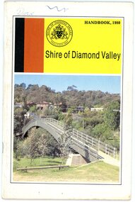
Book, Shire of Diamond Valley, Shire of Diamond Valley Handbook 1980, 1980_
Guide to services provided by Shire of Diamond Valley. The Shire of Diamond Valley was a Local Government Area located about 20 kilometres northeast of Melbourne. The shire covered an area of 74.38 square kilometres and existed from 1964 until 1994. Cover illustration of footbridge over the Plenty River at Flintoff Street. The span is 50 metres and cost $56,100 to build in 1978.Annual guide to services in Shire of Diamond Valley32 pages, col illus., maps. shire of diamond valley, greensborough, handbooks -
 Lakes Entrance Historical Society
Photograph - Paynesville Slipway, 1910 c
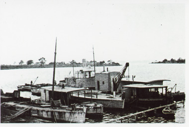
Photocopy of photograph has names of all the boats, W H Edgar, suction dredge called Paynesville, grab dredge called Priest Man, stores barge called Lady Harriet, a boat used to keep rivers free of snags called Snagger, sand hopper barge from W H Edgar in process of being dismantled. Information provided by Reg Schulz.Black and white photograph showing five boats / barges at slipway, one with crane. Little row boat in foreground at jetty. Point of land in background, Raymond Island, sparse vegetation. Paynesville Victoriaships and shipping, wharfs -
 Greensborough Historical Society
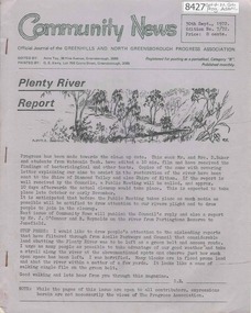
Newsletter, Greenhills and North Greensborough Progress Association, Community News: official journal of the Greenhills and North Greensborough Progress Association. 30th Sept.,1972. Edition No. 7/72, 30/09/1972
This edition includes a report on the Progress Association's September 1972 meeting, Councillors' report, Plenty river report, The rites of spring, Preparing for a hot summer, Tolai and the Spring Street happing, School news, Eltham Film Society, Letter to Editor. Supplement to September 1972 "Community News" Open forum. A digital copy of this Newsletter is available from Greensborough Historical Society.Newsletter, 14 p., illus. greenhills and north greensborough progress association, greenhills -
 Ithacan Historical Society
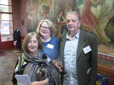
Photograph, Honouring Loula Rodopoulos, 2015
IPS treasurer Eugenia Vlass-Tsalikis and president Anthony Drakopoulos together with Maria Johnson were guests at a function at MacRobertson Girls' High School, which was held in honour of Loula Rodopoulos (nee Raftopoulos). Loula was very active the community and was a board member of the Victorian Women's Trust. The mural behind the guests depicts some of the Greek myths of the sea, the woodlands, the mountains and the rivers. A coloured photograph of two ladies and a man standing in front of a large mural in a gallery. -
 Flagstaff Hill Maritime Museum and Village
Photograph - Vessels, Sailing Ships, Vessels in the bay, 1890's
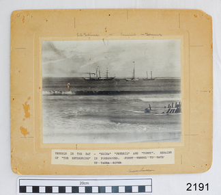
The photograph, taken in the 1890s, shows sailing ships and a wreck in Lady Bay, Warrnambool. Lady Bay was once a very busy port of trade in Warrnambool and was also called the Port of Warrnambool or Warrnambool Harbour. ENTERPRISE (1847-1850) NOTE: The “Enterprise” wrecked in 1850 in Warrnambool should not be confused with John Pascoe Faulkner’s ‘Enterprise’, which was wrecked in NSW in 1847. The 58-ton schooner Enterprise was built by David Hay in Waiheke, New Zealand in 1847 and registered by owners John Watson and Edward Byam in Melbourne, Australia. She was a single-deck sailing ship with two masts, used for carrying cargo such as local agricultural produce and general commodities between Melbourne and other colonial ports. On September 14th, 1850 the Enterprise had sailed from Melbourne under the control of the ship’s Master, James Gardiner Caught, and was moored in at the Tramway Jetty in Lady Bay, laden with wheat and potatoes. The vessel rode out a south-easterly gale but eventually dragged anchor and was beached, bow first and then broadside. Buckwall, a local indigenous man, braved the heavy surf and reached the stricken vessel with a rescue line, saving all five crew on board. There were no passengers on board. The Enterprise wreck was in an area called Tramway Jetty in Lady Bay. Since then the area has become the location of Lady Bay Hotel and now, in 2019, it is in the grounds of the Deep Blue Apartments. In fact, with the constantly changing coastline through built-up sand, the wreck site is now apparently under the No 2 Caravan Park on Pertobe Road, perhaps 150 metres from the high tide. Its location was found by Ian McKiggan (leader of the various searches in the 1980s for the legendary Mahogany Ship). The Warrnambool Wreck Enterprise is listed on the Victorian Heritage Database VHR S238. DIFFERENTIATING the New Zealand Schooner “Enterprise” from John Fawkner’s “Enterprize“ Dr Murray Johns, Melbourne, says in his article The Mahogany Ship Story, “…the Enterprise, wrecked in Lady Bay, Warrnambool in 1850 ... was soon covered by sand but was exposed again after several storms in 1887. “Samples of timber were then cut from the wreck, which would then have been buried for 37 years. In November 1887 the Warrnambool Standard reported that “the timber looks sound and hard, a penknife scarcely making any impression.” “For many years there was confusion about the identity of that ship in Lady Bay. Most people believed it was the wreck of John Pascoe Fawkner’s Enterprize, which had sailed from Tasmania to Victoria bringing the pioneer settlers to Melbourne in 1835. “In fact, as I documented in 1985, the Warrnambool wreck was of an entirely different ship, also called Enterprize [Enterprise], but built in New Zealand in 1847. Fawkner’s ship had already been sold to Captain Sullivan in 1845 and was wrecked on the Richmond Pier in northern New South Wales early in 1847. “In 1985 a piece of timber from the local Enterprise, which had been kept at the Warrnambool Museum since 1892, was identified histologically as a New Zealand timber, not Tasmanian timber such as blue gum, from which Fawkner’s Enterprize would have been built in 1830. This confirmed the identity of the Warrnambool Enterprize.”[Dr. M.W. Johns later wrote an article called “The Schooner Enterprise: A Final Word on a Historic Wreck.”] ABOUT THE S S EDINA The three-masted iron screw steamer SS Edina was built in Glasgow, Scotland, in 1854 by Barclay and Curle. She was adorned with the figurehead of the ‘fair maid of Judea’. The many years of service made SS Edina famous worldwide as the longest-serving screw steamer. (The term screw steamer comes from being driven by a single propeller, sometimes called a screw, driven by a steam engine.) SS Edina’s interesting history includes English Chanel runs, serving in the Crimean Ware carrying ammunition, horses and stores to the Black Sea, and further service in the American Civil War and later, serving in the western district of Victoria as well as in Queensland and carried gold, currency and gold prospectors Australia to New Zealand. SS Edina had the privilege of being an escort vessel to H.R.H. the Duke of Edinburgh during his visit to Australia in 1867. In March 1863 SS Edina arrived in Port Phillip Bay, Melbourne and was bought by Stephen Henty, of Portland fame, to work the cargo and passenger run from Melbourne – Warrnambool – Port Fairy - Portland. After a short time of working the run from Australia to New Zealand, with passengers and cargo that included gold and currency, she returned to her Melbourne - Warrnambool – Port Fairy run, with cargo including bales of wool produced in the western district of Victoria. The Warrnambool Steam Packet Company purchased SS Edina in 1867; she was now commanded by Captain John Thompson and Chief Engineer John Davies. She survived several mishaps at sea, had a complete service and overhaul and several changes of commanders. In 1870 SS Edina was in Lady Bay, Warrnambool, when a gale sprung up and caused a collision with the iron screw steamer SS Dandenong. SS Edina’s figurehead was broken into pieces and it was not ever replaced. SS Edina was re-fitted in 1870 and was then used as a coastal trader in Queensland for a period. She was then brought to Melbourne to carry cargo and passengers between Melbourne and Geelong and performed this service from 1880-1938. During this time (1917) she was again refitted with a new mast, funnel, bridge and promenade deck, altering her appearance. In 1938, after more collisions, SS Edina was taken out of service. However, she was later renamed Dinah and used as a ‘lighter’ (a vessel without an engine or superstructure) to be towed and carry wool and general cargo between Melbourne and Geelong. In 1957, after 104 years, the SS Edina was broken up at Footscray, Melbourne. Remains of SS Edina’s hull can be found in the Maribyrnong River, Port Phillip Bay. This photograph is significant for its association with the screw steamer SS Edina, heritage listed on the Victorian Heritage Database VHR S199. She had endeared herself to the people of Port Phillip Bay as a passenger ferry, part of their history and culture. She played a significant role in the Crimean War, the American Civil War and the gold rush in New Zealand. She also served western Victoria for many years in her cargo and passenger runs. The SS Edina is famous for being the longest-serving screw steamer in the world. After spending her first nine years overseas she arrived in Melbourne and her work included running the essential service of transporting cargo and passengers between Melbourne and the western Victoria ports of Warrnambool, Port Fairy and Portland. The SS Edina was purchased in the late 1860s by the local Warrnambool business, the Warrnambool Steam Packet Co. and continued trading from there as part of the local business community. Her original ‘fair maid of Judea’ figurehead was broken to pieces in a collision with another vessel (the SS Dandenong) in a gale off Warrnambool, Victoria, in 1870. The photograph is significant for its association wreck of the Victorian Heritage Listed schooner Enterprise, VHR S238, being a New Zealand-built but Australian-owned coastal trader. The wreck was also significant for its association with the local indigenous hero, Buckawall, who saved the lives of the five crew on board. Photograph "Vessels in the Bay". Black and white photograph of several vessels in Lady Bay, Warrnambool, including some small vessels and "S.S. Edina", the "Peveril" and "Tommy", plus the remains of the wrecked vessel "Enterprise" in the foreground. Photograph is mounted on beige card with label describing the vessels, plus pencilled vessel names. There are several pin holes in each corner of the photograph. Typed label under the photograph “VESSELS IN THE BAY – “EDINA” “PEREVIL” AND “TOMMY”. / REMAINS OF “THE ENTERPRISE” IN FOREGROUND. (Also crossed out on the label “FIRST VESSEL TO SAIL UP YARRA RIVER). In pencil script above the vessels on the photograph “S.S. Edina”, “Peveril” “Tommy”. On the reverse is a printed sticker with “F-Ph 59/2 74”, red felt-tip pen “88”, green pen script repeating the text that is under the photograph on the front.flagstaff hill, warrnambool, shipwrecked-coast, flagstaff-hill, flagstaff-hill-maritime-museum, maritime-museum, shipwreck-coast, flagstaff-hill-maritime-village, enterprize, port of warrnambool, warrnambool harbour, peveril, tommy, ss edina, lighter dinah, warrnambool steam packet company, lady bay, pleasure steamer, edina, trade, travel, screw ship, coastal trader, cargo, victoria, buckawall, indigenous rescue, indigenous hero -
 Wodonga & District Historical Society Inc
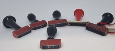
Functional object - Railway Station stamps Cudgewa Line
Cudgewa Line -The Cudgewa railway line opened in stages between 1889 and 1921. The first section from Wodonga to Huon opened on 10 September 1889. It was extended to Bolga on 18 July 1890, Tallangatta on 24 July 1891 and then to Shelley on 13 June 1916. Shelley was the highest station in Victoria. It extended further on to Beetomba on 10 April 1919 and finally reached Cudgewa on 5 May 1921. The line had 1 in 30 grades and trestle bridges that have been heritage listed. In 1919, the line was used to carry materials for the construction of Hume Weir, and three years later a spur line connecting Ebden to the weir was opened. In the 1960s, Cudgewa became the railhead of materials for the Snowy Mountains Scheme. The last passenger service from Wodonga to Tallangatta ran on 30 September 1961. The turntable and passenger platform at Cudgewa were abolished in 1976.6 Rubber and wood stamps used in the stations along the Cudgewa Line. The stamps were primarily used to acknowledge receipt of small freight items carried on the Cudgewa LineOn individual stamps: 1. TALLANGATTA 1476 2. BULLIOH 1477 3. BEETOOMBA 1484 4. KOETONG 1480 5. SHELLEY 1482 6. CORRYONG 1487cudgewa rail line, victorian railways, closed victorian railways -
 City of Moorabbin Historical Society (Operating the Box Cottage Museum)
Book, Globe Press Pty. Ltd, Buckley's hope : the story of Australia's wild white man, 1981
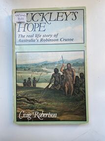
A small soft cover book with a blue/green cover,on the front cover is a painting of early Australia with Indigenous Australians hunting with spears alongside them is a European with long unkept hair and a beard dressed in animal skins,on the back cover is text by the author giving a brief outline of the book.buckley, sorrento, robinson crusoe, port phillip, van diemen's land, colonialism, 1840, convicts, indigenous tribes. -
 Warrnambool and District Historical Society Inc.
Certificate - Open Commonwealth Parliament, 1901
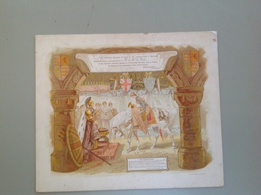
This is an invitation to George and Annie Rolfe of Lyndoch, Warrnambool, to attend the opening of the first Australian Parliament in Melbourne in May 1901. A smaller invitation card was first sent to the recipients and this larger invitation was sent after the event for the recipients to keep as a souvenir. The six Australian colonies became six Australian States in the newly-formed Commonwealth of Australia in January 1901. George Rolfe (1836-1919), a tea merchant from Melbourne, began buying blocks of land in Warrnambool near the mouth of the Hopkins River in the 1870s. By the early 1880s Rolfe owned 50 acres of land in the town and other nearby pastoral properties. He used the existing building on the land near the mouth of the Hopkins River as holiday accommodation, calling the property Lyndoch and adding stables, bone and chaff sheds, jetty, boathouse, reservoir and windmill and an extensive garden. George Rolfe spent most of his later life at Lyndoch. Today the area is the site of an aged care facility. This certificate is of considerable importance for two reasons: 1. It is an important memento of a signal event in Australia’s history – the Federation of the States in 1901. 2. The certificate was an invitation to George Rolfe of Lyndoch and his wife. Rolfe was a prominent Warrnambool person at that time. This is a piece of cardboard containing an illustration of a young queen in battle dress and on horseback bowing to an image of Britannia. The queen is about to be crowned. There are several lady attendants in the background and two large columns depicted on the sides of the illustration with shields and banners. An extract from Kipling’s poem, The Young Queen, is printed at the bottom of the card. The invitation is coloured in brown, yellow, white and orange tonings. The name of the recipient of the card is handwritten in black ink. The card is slightly scuffed and marked. The card is an invitation to Mr and Mrs Rolfe to attend the Opening of the First Australian Parliament in Melbourne in May 1901. ‘Mr & Mrs G. Rolfe’ federation in australia, george rolfe and family, history of warrnambool, lyndoch warrnambool -
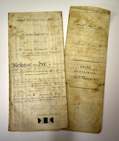 Warrnambool and District Historical Society Inc.
Legal record - Two documents regarding purchase and sale of land, George Barber, Port Fairy solicitor, early 1850s
Thes two documents deal with the purchase and sale of land near Warrnambool by Thomas Simpson. The first document, called a Grant by Purchase, is dated 1852 and shows that Thomas Simpson purchased from the Crown, Allotment 146 (22 acres two roods) adjoining the property of Wollaston on the Merri River and the Mortlake Road, north of Warrnambool. The cost was 90 pounds. The second document is dated 1853 and shows that Thomas Simpson sold this Merri River allotment of 22 acres to Eliza Bromfield, in conjunction with her husband, John Davenport Bromfield, for the sum of 110 pounds. The property of Wollaston was owned by the Manifold family and in the 1850s was leased to William Simpson, the brother of Thomas who had an adjoining property called Wooramoota. John Davenport Bromfield was a Colac farmer who played a prominent part in the early history of that town. His brother James Astley Bromfield, an early chemist in Warrnambool is important in Warrnambool's history.These two items are of considerable significance because they are amongst the earliest legal documents we have connected to Warrnambool's history and because they concern three early pioneers of the district. They also have a connection to Wollaston, an important early property in the Warrnambool district..1 A piece of light parchment paper, stained with age and folded in three places. It contains printed and handwritten material, a copy of a signature and a white seal. .2 A piece of parchment paper folded in half and then folded again in two places. It contains ruled red lines, handwritten material in black ink and the remains of a red seal. The top of the first page has a cut-out fluted pattern.wollaston, john davenport bromfield, thomas simpson, eliza bromfield, george barber solicitor -
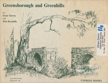 Eltham District Historical Society Inc
Book, Irene Turvey et al, Greensborough and Greenhills / words by Irene Turvey ; Drawings by Ron Reynolds, 1973
Pen and ink sketches accompanied by appropriate text in double page spreads. Contents cover : Blue stone bridge, Introduction, House cnr Church and Hailes Street, House - 25 Hailes Street, Yandell Reserve, Greensborough Hotel, Lobb's Kiosk, House - 49 Grimshaw Street, View of Greensborough (from Delphin Crescent), Railway Station, Old Barn (near Greensborough Railway Station), Partington's Flat and River Valley, Rand Street Bridge, Lower Main Street, Greenbriar Nursery, Hitching rail, Ashmead - Dr Cordner's Home, Greensborough Primary School, House - cnr St Helena and Diamond Creek Raods, Sondermeyer's Hill, Methodist Church, Football Pavilion, Cemetery, St Katherine's Church, St. Helena, Civic Centre, Briar Hill Timber Mill, 24 River Street, Kelly's Garden Supplies, 158 Main Street, Old Swimming pool, 105 Main Street.Hardback; 62 p. : ill., map ; 19 x 25 cm.ISBN 0909807108 Signed by author and illustrator Two copiesgreenhills, greensborough -
 City of Moorabbin Historical Society (Operating the Box Cottage Museum)
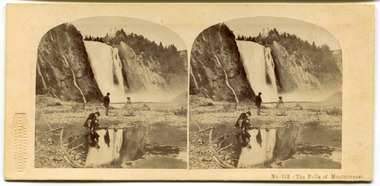
Leisure object - Stereograph card, The Falls of Montmorenci, Quebec, 1908
The London Stereoscopic and Photographic Company began in 1854 as the London Stereoscope Company (LSC), from 1856 was known as the London Stereoscopic Company, and from May 1859 as the London Stereoscopic and Photographic Company.This card is from the collection of a pioneer family of the City of Moorabbin.Stereograph Card manufactured by 'The London Stereoscopic Company' 54 Cheapside - black and whiteThe Falls of Montmorenci, near Qubec, Canada "These beautiful falls are eight miles distant from Quebec, on the Montmorenci river and situated at a point where the river is sixty feet wide. The descent of the torrent is 250 feet higher than those of Niagra, but only about fifty feet in width. The effect of the view of these falls upon the beholder is most delightful. The river at some distance seems suspended in the air, in a sheet of billowy foam. The water which first breaks over the ledge in on sheet is more and more divided as it plunges against the successive layers of rock, which it almost completely veils from view; the spray becomes very delicate and abundant, from top to bottom, hanging over, and revolving round the torrent, till it becomes lighter and more evanescent than the whitest fleecy clouds of summer." In the winter time the spray form the fall freezes in the form of a cone to a height of nearly 100 feet, and at such time the falls a greatly resorted to for the amusement of sliding down the cone with the tobogen, or Indian sleigh. The comparatively short distance from the city and the extreme beauty of the scenery along the whole route, render these falls an attractive scene for the inhabitants, who account a visit amongst their usual recreations.quebec, canada, the falls of montmorenci, moorabbin, stereograph cards -
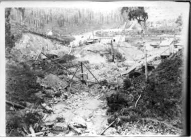
 Kiewa Valley Historical Society
Photograph - Folder of Photographs – Photocopied set of 10 black and white photographs (pages 19 - 28) from the display folder put together by KVHS to document life on the Kiewa Valley Hydro-electric Scheme
Although the Kiewa Hydro-Electric Scheme was first proposed in 1911, construction did not commence until 1938. As part of the push to cut electricity costs and diversify supply, the Victorian Government (circa 1930) initiated the conversion from primarily brown coal supply to hydro – electricity. Field investigations during the 1940’s resulted in a new proposal for a scheme that had more than double the capacity of the 1938 scheme. The Kiewa Hydroelectric Scheme became the largest scheme of its kind in the State Of Victoria and the second largest scheme in Australia. The number of personnel involved in the planning and construction of the scheme increased dramatically. During the late 1940’s, most activity centred around the construction of the West Kiewa Power Station, Rocky Valley Reservoir, McKay Creek Power Station and the Bogong Creek Aqueduct.A common thread across all the larger hydro scheme constructions was the need for workers, both qualified and unqualified who came from around the world seeking a new life for themselves and their families. New accommodation and facilities were required for the army of workers engaged in construction in often remote and wild areas. The SEC had a high demand for timber, and set up the first of a number of sawmills at Bogong Creek in 1939 and set up the first hardwood logging in the headwaters of the Kiewa River. These new ‘towns’ such as Mt Beauty and Bogong, survived, serving the needs of operational personnel and their families, and expanding with growth of new industries. Mount Beauty, and to a lesser extent Bogong, are among these places. Large A3 size spiral bound display folder containing 21 pages of photocopied black and white photographs of various aspects of the early days of the Kiewa Valley Hydro-electric scheme including equipment, various work sites and photographs of workers and their families. 1-Allis Chalmers Tractor School 2- Gardens outside Administrative Office – Mt Beauty 3- Mt Beauty house – 1950 4-Bridge over Pretty Valley River, Bogong 5-Rocky Valley Spillway Tunnel break through 6-Ni 1 Headrace Tunnel drilling face 7-No 4 Power Station Drilling 8-Clover Dam Flood Waters 9-No1 Head Race Tunnel Portal Building 10-Clover Dam 1-STATE ELECTRICITY COMMISSION OF VICTORIA Date: 5.9.49 Time: 10amm No K5174 Kiewa Hydro Electric Works Allis Chalmers Tractor School Page number 19 2-STATE ELECTRICITY COMMISSION OF VICTORIA Date: 22.2.50 Time: 3.30pm No K5601 Kiewa Hydro Electric Works Gardens outside Administrative Office – Mt Beauty Page number 20 3-Mt Beauty house – 1950 Page number 21 4-STATE ELECTRICITY COMMISSION OF VICTORIA Date: 23.10.50 Time: 11.15am No K6331 Kiewa Hydro Electric Works Bogong-Bridge over Pretty Valley River Page number 22 5-STATE ELECTRICITY COMMISSION OF VICTORIA Date: 23.6.50 Time: 2.30pm No K5844 Kiewa Hydro Electric Works ROCKY VALLEY SPILLWAY TUNNEL BREAK THROUGH Page number 23 6-20/3/52 – No. 1 Headrace Tunnel Drilling face (E.E.E. contract) Page number 24 7-6/6/52 – No 4 Power Station – Drilling Page number 25 8-STATE ELECTRICITY COMMISSION OF VICTORIA Date: 6/6/52 Time: No K7113 Kiewa Hydro Electric Works Clover Dam Flood Waters Page number 26 9-STATE ELECTRICITY COMMISSION OF VICTORIA Date: Oct 1952 Time: No K7239 Kiewa Hydro Electric Works No. 1 HEAD RACE TUNNEL PORTAL BUILDING. Handwritten underneath – This information from Ron White-the later Principal Hydro Engineer of the SEC. Oct 1952 Location incorrect? All work on No 1 had ceased after financial crash of 1951. This photo would refer to No 4 Headrace Tunnel? Page number 27 10-STATE ELECTRICITY COMMISSION OF VICTORIA Date: Jan 1953 Time: No K7307 Kiewa Hydro Electric Works CLOVER DAM Page number 28 secv; kiewa hydro electric scheme; bogong; mt beauty; construction area -
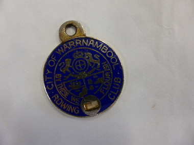 Warrnambool and District Historical Society Inc.
Badge - City of Warrnambool Rowing Club
The Warrnambool Rowing Club was formed in the 1880s when there was a renewed interest in rowing and many young men were taking up competitive rowing. The Warrnambool Rowing Club used the new boatsheds erected in 1885 by Fanny Nelson near the mouth of the Hopkins River where the Hopkins Hotel was operating (Simpson Street). This badge belonged to a member (number 333) in the 20th century but the name of the owner is unknown.This badge is of interest but has no provenance so is useful for display purposes onlyThis is a small metal badge enamelled in blue and silver. It has a loop at the top for attachment to a chain or pin and a hole at the bottom – another attachment device. The back is gold-sprayed. Front: City of Warrnambool Rowing Club, W.C.C. logo , ‘By These We Flourish’ Back: Not Transferable, 333, Taiwan warrnambool rowing club, warrnambool, fanny nelson -
 Kiewa Valley Historical Society
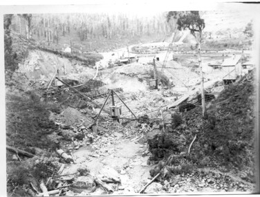
Black and white photograph, Early construction of Junction Dam Wall, c1940
In December of 1939 the excavation of a diversion tunnel was commenced to divert water from the East Kiewa River to allow construction of the dam wall. This was completed in February 1940. Lewis Construction Co. had the contract with excavation starting in February and the first batch of concrete placed in September. In 1942 the S.E.C. took over the construction and the wall was completed in March, 1944. Type of construction: reinforced concrete slab buttress.Of historical importance in the Kiewa area as it shows the form work and preparation necessary before the pouring of concrete for the first dam in the hydro electric scheme. The destruction caused by the 1939 bushfires is also evident in the upper left hand corner.A black and white photograph of the early construction of Junction Dam wall viewed from downstreamOn back of photograph (left hand upper corner) Junction Dam 4-4-81 Dam viewed from downstream 352 Time to use for correct Exp. 40 secjunction dam, bogong, secv -
 Kiewa Valley Historical Society
Black and white photo of Junction Dam wall under construction, c1940
In December of 1939 the excavation of a diversion tunnel was commenced to divert water from the East Kiewa River to allow construction of the dam wall. This was completed in February, 1940. Lewis Construction Company had the contract with excavation starting in February and the first batch of concrete placed in September. In 1942 the SECV took over the construction and the wall was completed in March, 1944. Type of construction: Reinforced concrete, slab buttress.Of historical importance in the Kiewa area as it shows the form work and preparation necessary before the pouring of concrete for the first dam in the hydro electric scheme. The destruction caused by the 1939 bushfires is also evident in the upper left hand cornerBlack and white photo, early construction of Junction Dam Wall, viewed from downstreamOn back of photo (left hand upper corner) Junction Dam 5-4-81 Dam viewed from downstream. 352 Time to use for correct exp. 40 sec.bogong, junction dam, secv -
 Warrnambool and District Historical Society Inc.
Document, Sticker Warrnambool Botanic Gardens 150 years A Growing Legacy, 2016
This sticker was issued to celebrate the 150th anniversary of the Warrnambool Botanic Gardens. These Gardens were first established in the early 1850s on a site near the mouth of the Hopkins River but this site proved unsuitable and the Gardens were moved to the present location (Cockman Street/ Botanic Road) in 1866. In 1877 William Guilfoyle was commissioned to provide a plan for the Botanic Gardens . A prominent curator was Charles Scoborio 1872 to 1906. This sticker is a minor interest as a memento of the 150th anniversary in 2016 of the Warrnambool Botanic Gardens A white sheet of paper containing a circular shaped sticker with blue print and a logo in green and purple. The printing is in black and purple.Warrnambool Botanic Gardens 150 years A GROWING LEGACYwarrnambool botanic gardens, william guilfoyle -
 Warrnambool and District Historical Society Inc.
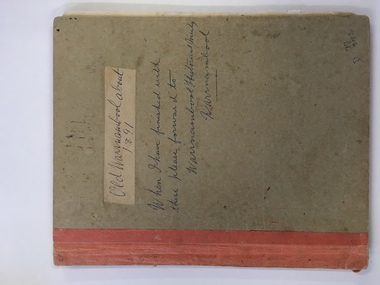
Book, Picturesque Warrnambool, C1891
This book presents a pictorial and written record of Warrnambool in 1891.It covers a wide range of topics. It provides statistical evidence relating to public buildings and organisations of that era, as well as basic information about district points of interest. The Mechanics Institute, the Common, Albert Park, the rivers, the Museum and the Sea Baths are all mentioned. The various drawings and advertisements provide a list of businesses which were prevalent at the time.As this book is one of only two complete copies documented to be still in existence, it is of considerable significance and importance to our collection. The drawings and text are artistically very much of the era and are aesthetically pleasing.Plain grey card cover with fabric binding. Handwriting on front cover and inside front cover. It contains a number of black and white and coloured plates depicting scenes of Warrnambool and the district. Approximately 70 pages.Old Warrnambool about 1891 hand written on label on front cover, underneath is also written “When I have finished with these please forward to Warrnambool Historical Society Warrnambool. D 77, 252 in bottom RHC of cover. picturesque warrnambool,, warrnambool 1891, -
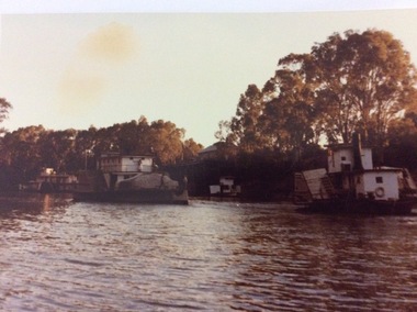 Port of Echuca
One colour photograph and one colour negative, 03/04/1984
These paddle steamers were accompanying the P.S Adelaide back to the Echuca Wharf after being re-launched on 03/04/1984. The P.S Adelaide had been displayed in the Hopwood Gardens since 1960, and the City of Echuca Mande a decision to launch the paddle steamer back into the river to be used as a working tourist attraction. This photograph relates to P000059.3, P000060.3, P000061.3, P000062.2, P000063.3, P000071.This photograph is significant as it shows the state of the Echuca Wharf in 1984. It also shows the state of the P.S Adealide after sitting idle for so many years. In 1984, the Tourism Industry was still developing in the Echuca region.Colour photograph and negative showing the P.S Adelaide heading upstream towards the Echuca Wharf, after being re-launched on 03/04/1984. The P.S Pevensey, the P.S Emmylou and P.S Etona can also be seen.On boat Pevensy, is obscured.p.s adelaide, hopwood gardens, p.s emmylou, echuca wharf -
 Greensborough Historical Society
Article, Norm Colvin, Events leading up to the Plenty Ladies' Petition 1842, 2020_
This article, written and researched by Norm Colvin, GHS Secretary, identifies the people involved in the events leading to the petition to the Governor of Victoria, C. J. La Trobe, from 'Ladies resident on Plenty River' requesting protection from bushrangers, 5 May 1842. It identifies the bushrangers, the owners of the stations robbed, the group of men who rode out to assist and the identity of the "ladies" who signed the petition.This article identifies the people involved in the incidents, a list of locals in the 1840s.12 pages typescript, map.plenty river, bushrangers, petitions -
 Greensborough Historical Society
Article - Article, Newsletter, Janeen O'Connell, William and Margaret Blay, by Janeen O'Connell, 2022
The Blays moved from their farm in New Norfolk, Van Diemens Land to an allotment at Greenhills on the Plenty River in 1841, but William was injured in a fall and was unable to work this farm, which was repossessed by the bank, causing him to fall into a severe depression and subsequently admitted to Yarra Bend Insane Asylum, where he died in 1849. Article first published in "Pioneer Echo" no 226, Oct-Nov 2022.1 p. typescript, copied from newsletterblay family, william blay, greenhills -
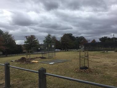 Greensborough Historical Society
Photograph - Digital Image, Anne Paul, Opening of restored Old Lower Plenty Bridge 2001 - area adjacent, 14/03/2001
The opening of the restored Old Lower Plenty Bridge, opened on 14/03/2001 by the Minister for Environment and Conservation Sherryl Garbutt MLA and Mayor of Banyule Cr Dale Peters. The project was jointly funded by Banyule Council and Parks Victoria. The restored bridge is the oldest remaining bridge in Nillumbik and forms part of the Plenty River Trail. this photograph shows the area adjacent to the bridge on the day of the opening.Digital copy of colour photographlower plenty, lower plenty bridge, sherryl garbutt, dale peters, banyule council, parks victoria -
![Newspaper clipping [copy], Greensborough farm 8500 [pounds], 23/12/1947](/media/collectors/4f729f5697f83e03086015b8/items/5d1d78dc21ea6a1138d1fd4a/item-media/5d1dcff421ea6b11381717d8/item-fit-380x285.jpg) Greensborough Historical Society
Greensborough Historical SocietyNewspaper clipping [copy], Greensborough farm 8500 [pounds], 23/12/1947
Corrabert Park was owned by Francis Flintoff, sold c. 1924 to Mr. E. Fullwood, who sold the property in December 1947 to Mr. W. M. Bamford for 8500 pounds. The land had frontage to the Plenty River and water from the MMBW aqueduct which passed through the property. There was a residence and two small rented cottages on the property. The area is currently known as Apollo Parkways.Copy of news clipping.Corrabert Park sold - newspapers.comcorrabert park, apollo parkways