Showing 7095 items matching "snowy-river"
-
 Greensborough Historical Society
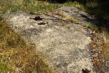
Photograph - Digital image, Marilyn Smith et al, Janefield Precinct: World War 2 era concrete shed base, sump and raised edge, 27/11/2014
Janefield Precinct: World War 2 era concrete shed base, sump and raised edge. The remains of this site are between Greensborough and Janefield. A RAAF Hygiene Training Camp was located on the Plenty River, just south of the Janefield community. It was in use from 1944 to 1946. The Camp was constructed from salvaged materials. Instruction included building and maintenance of grease traps, latrines, elementary plumbing and carpentry.Early remains of a WW2 training camp Digital colour photograph.janefield -
 Halls Gap & Grampians Historical Society
Newspaper - Photocopy, 28/12/2001
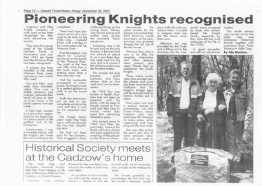
This is an article about unveiling of a plaque at the Wannon River campsite, to commemorate the Knight family and their 'Coonara" tea-rooms which opertated on that site in 1931. The photo in the article shows Ray Knight, Emma Watson and Emma's daughter standing behind the plaque. The article was written by Ida Stanton for the Stawell Times-News, 'Halls Gap Extra" and published on Friday, 28 December 2001, p.16.A photocopy of a newspaper article titled "Pioneering Knights recognised".people, knight -
 Warrnambool and District Historical Society Inc.
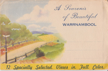
Souvenir - Post Card 12 views of Warrnambool, Nucolorvue Productions, 1950's
This type of folded postcards was popular with tourists in the 1940s, 50s, and 60s and often kept by them for many years afterwards. The views of Warrnambool here, taken about the 1950s, were typical of the Warrnambool postcards available at the time and were mass-produced as many examples survive today. They include photographs of Hopkins Falls, the beach and harbour, Liebig Street, Hopkins River, coastal scenery and the Botanical Gardens. These postcards are of some historical interest, though the photographs appear frequently in many publications. They also have a social significance showing what tourists bought 60 or more years ago.This is a packet in envelope form containing 12 coloured postcards of views of Warrnambool about the 1950s. The photographs are printed on buff-coloured paper and fold up to envelope size so that they can be sent by post. The front cover includes three dotted lines for the address and the back cover has a space to include the name of the sender. One page gives some general information on Warrnambool. Front cover: ‘A Souvenir of Beautiful Warrnambool’, ’12 Specially Selected Views in Full Color’ Back cover: ‘From…’ , ‘Published by Nucolorvue Productions, Elwood, Victoria’ tourism, warrnambool -
 Creswick Campus Historical Collection - University of Melbourne
Still Image, 1964 - 1966
Subject: Combienbar River Project. 1964. 2 brown envelopes marked Run 16, 17 of c.18 prints total. Subject: Errinundra Project. 1966. 2 brown envelopes marked Run 12, 13 of c.14 prints total. Stored in an unmarked brown cardboard file box . Related to item 1507. Marked Errinundra Project..Combien Project...Ballarat Plantation.Aerial Photographs -
 Royal Brighton Yacht Club
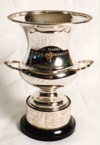
Cup, Alan Robinson Memorial Trophy (Cup)
Alan Robinson Memorial Trophy (Cup) Donor : Keith Farfor Deed of Gift: No Alan Robinson was the navigator on Keith Farfor’s yacht Super Star. He was killed in a car accident on the banks of the Yarra River. The race is a combined division race from RBYC to the QCYC. The trophy is awarded to the PHD handicap winner and is raced early June of each year. First Winner: Bindi D Buxton alan robinson, memorial, trophy, phd, combined division -
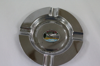 Wodonga & District Historical Society Inc
Memorabilia - Souvenir Ashtray Hume Weir Wodonga
Metal, china and glass ashtrays and other small pieces carrying scenic views of holiday destinations were a popular kind of souvenir during much of the 20th century. The pictures on the souvenirs ranged across natural beauty spots (beaches, waterfalls, rivers), civic buildings and monuments (town halls, war memorials), and indicators of local progress (commercial centres and occasionally even industrial sites).This ashtray is representative of a range of souvenirs used in the 20th century to depict Wodonga, Victoria and also on a State and National level throughout Australia.A metal circular ashtray including a coloured enamel image of the Hume Weir in the cenre."Above the central image "HUME WEIR" Beneath the central image "WODONGA"souvenir, hume weir, wodonga, ashtray -
Port Melbourne Historical & Preservation Society
Pamphlet - The Pubs of Port 2017, Pat Grainger, Walks around Vintage Port No.7, Apr 2017
Update and reprint of Pubs of Port Walk. Supported by CoPP. The original Pubs in Port Walk was No 7 with No 6 reserved for Bend on the River: Westgate Park. The Westgate Park walk was not produced so the updated versions the Pub walk in 2001 and 2012 became No 6 however with the introduction of a Beacon Cove to Webb Trail as a new Walk No 6 in 2016, this version of the Pub walk (2017) reverted to No 7.Port Melbourne Historical and Preservation Society publication, "Walks around Vintage Port", "No.7 Pubs of Port" 2017 Edition.built environment - commercial, business and traders - hotels -
 Lakes Entrance Historical Society
Photograph, 1999
In late 1958 bore put down in an attempt to obtain good quality water for a reticulated town water supply. Water unsuitable, but during drought years when water supply from Nicholson River was restricted, water from this bore available for public use. Bore plugged, structure removed December 2000. Site marked with plaque March 2001, by Lakes Entrance Historical Society.Colour photograph of the head works including feed pipe of water bore sunk in late 1958 on the Public Reserve bound by Marine Parade and the highway approach to North Arm Bridge, Lakes Entrance, Victoria.water supply, public utilities -
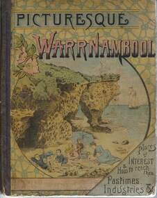 Warrnambool and District Historical Society Inc.
Book, Picturesque Warrnambool, 1891
This book presents a pictorial and written record of Warrnambool in 1891.It covers a wide range of topics. It provides statistical evidence relating to public buildings and organisations of that era, as well as basic information about district points of interest. The Mechanics Institute, the Common, Albert Park, the rivers, the Museum and the Sea Baths are all mentioned. The various drawings and advertisements provide a list of businesses which were prevalent at the time. As this book is one of only two complete copies documented to be still in existence, it is of considerable significance and importance to our collection. The drawings and text are artistically very much of the era and are aesthetically pleasing. Cardboard cover with picture of people on beach in tones of yellow, pink and blue sitting within a circle. Dark purple cloth spine binding. Back cover has drawing of Western Hotel. Pages are not numbered and there are a number of coloured and black and white drawings. Title is in dark purple and Warrnambool is in pink and blue tonesOn front cover “The Mermaids Caves” 1896. 1891 written in pen beneath roman numerals on bottom of title page. List of numbers written down title page in black pen.warrnambool, picturesque warrnambool, warrnambool 1891,, warrnambool, warrnambool 1891 -
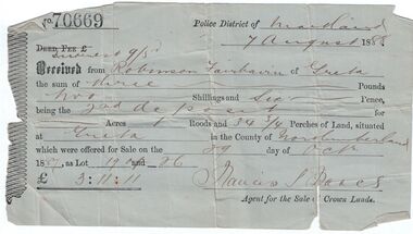 Bendigo Historical Society Inc.
Administrative record - Land purchase records - Maitland NSW, 1888-1889
Northumberland County was one of the original Nineteen Counties in New South Wales and is now one of the 141 Cadastral divisions of New South Wales. The Greta area was first colonized by Europeans around Anvil Creek in the 1830s. When the town was surveyed in 1842 it was given the name Greta, possibly after a small river in Cumberland, England. Coal mining was established in the area in 1862 with the development of a railway station.Robinson Fairbairn Collection: Two documents. 1. Receipt for payment from Robinson Fairbairn of Greta for purchase of land at Greta, NSW. Dated 7th August 1888. Receipt for £3/11/11 includes Interest noted at top. 2. Invoice to Mr. Robinson Fairburn for land purchase in account with Sparke and Clift, Auctioneers, West Maitland. mining, robinson fairbairn collection, maitland, northumberland, greta nsw, sparke and clift, coal -
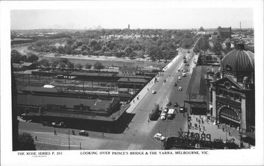 Melbourne Tram Museum
Postcard, Rose Stereograph Co, "Looking over Princes Bridge & The Yarra, Melbourne", c1941
Rose Series postcard No. P 201, titled "Looking over Princes Bridge & The Yarra, Melbourne" with a view including Princes Bridge Railway Station, Batman Ave. tram terminus with two trams, The Yarra River, the bridge, and the entrance to Flinders St station. The south west curve track from Swanston Street into Flinders Street is visible along with various Safety Zones at the tram stop.Yields information about St Kilda Road, Princes Bridge c1941Postcard - printed real photograph with Rose Stereograph Co. name on the rear. Two copies held.tramways, flinders st station, st kilda road, princes bridge station, princes bridge, yarra river, flinders st, trams -
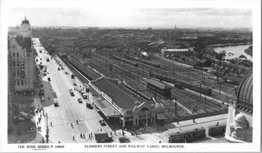 Melbourne Tram Museum
Postcard, Rose Stereograph Co, "Flinders Street and Railway Yards, Melbourne", 1930s
Rose Series postcard No. P 10660, titled "Flinders Street and Railway Yards, Melbourne" showing Princes Bridge Station buildings, the extensive railway yards of the time, signal boxes, Batman Ave, and the Yarra River. There are two trams visible in Flinders Street and another two trams, W2 class, in Swanston Street - both of these seem to have wind deflectors rather than doors on the 'on-side"Yields information about Princes Bridge and the associated railway yards during the 1930s.Postcard - printed real photograph with Rose Stereograph Co. name on the rear.tramways, trams, flinders st station, yarra river, flinders st, princes bridge station, railways, swanston st, w2 class -
 Federation University Historical Collection
Photograph, "Herbig Family Tree", South Australia, c1980s
Friedrich Herbig left Germany in 1855 and later that year arrived in South Australia. He went to work on a farm and made his home in a large hollowed-out base of a river redgum tree. In 1858 Friedrich married Caroline Rattey and they lived together in the tree. They had sixteen children. After the second child was born they moved to a two-roomed pine and pug hut that Friedrich builtMembers of the Chatham family visit the "Herbig Family Tree" in South Australiachatham-holmes collection, friedrich herbig, south australia, river redgum, caroline rattey, hollowed-out base of tree, elizabeth chatham, philip chatham, architecture, housing, caroline herbig, family history, genealogy -
 Warrnambool and District Historical Society Inc.
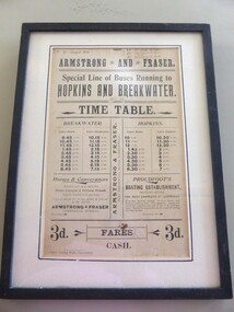
Poster - Armstrong and Fraser timetable, Late 19th Century
This poster is a time table for the coaches operated by Armstrong and Fraser.Their stables were in Liebig Street, Warrnambool next to the Commercial Hotel (The Whalers Hotel today) Armstrong and Fraser commenced business in 1882 and were prominent in Warrnambool at the end of the 19th century and the beginning of the 20th century. The kept as many as 70 horses in their stables and operated a daily timetable for tourists especially those going to the mouth of the Hopkins River and to the breakwater. This poster is of considerable interest as the time table indicates the extensive business of an early coach service in Warrnambool over 100 years ago. The poster comes possibly from the old Warrnambool Museum.This is a sheet of paper containing black printing and handwriting in black ink. It is encased in a black wooden frame with a white cardboard surround and a black border. It has glass protection. There is string and wire at the back for hanging the item . ARMSTRONG* AND * FRASER Special line of buses Running to HOPKINS AND BREAKWATER TIME TABLE (Also other detail re fares, Proudfoot's boating establishment and horses and conveyances) ( Handwriting 87,90, 91 January to March July to Sept. April to June Jany to March) warrnambool, bus timetable, armstrong and fraser -
 Warrnambool and District Historical Society Inc.
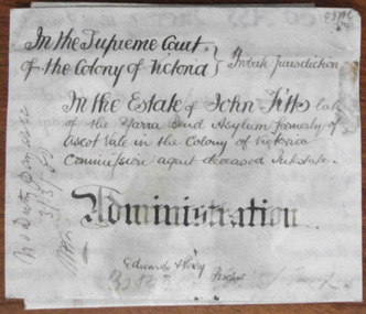
Document - John Fitts Letters of Administration 1879, 1879
No information has been found on the Commission Agent John Fitts except that he died at the Yarra Bend Asylum at the age of 51 and was formerly a resident of Ascot Vale, a suburb of Melbourne. His estate was valued at £600. Yarra Bend Asylum, near the junction of the Yarra River and the Merri Creek was the first institution for the mentally ill in Victoria and operated from 1848 to 1925. Tait collection: item 5 of 62This document is only of interest in that it came from the former legal offices of Mackay Taylor in Kepler Street, Warrnambool. It originally came from Thomas Goodall, a legal clerk in the office of the lawyer Ernest Chambers who passed it on to George Mackay, the lawyer in the forerunner firm of Mackay Taylor where it remained until the firm of Mackay Taylor ceased to exist and the buildings were cleaned out. This is a piece of parchment paper with printed black lines and handwritten material in black ink. There is a fold at the bottom of the document with a seal of the Supreme Court of the Colony of Victoria attached by a green ribbon. The document is slightly discoloured but is otherwise in good condition. ‘In the Supreme Court of the Colony of Victoria, Probate jurisdiction, In the Estate of John Fitts, late of the Yarra Bend Asylum, formerly of Ascot Vale in the Colony of Victoria, commission agent, deceased intestate, Administration, Edwards and Perry, Proctors’yarra bend asylum, john fitts, warrnambool -
 Warrnambool and District Historical Society Inc.
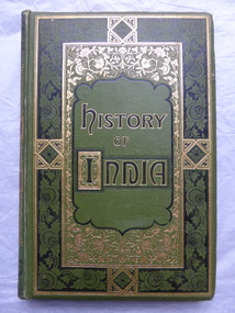
Books, History of India, 1870s and 1880s
These books appear to have been published in successive years as the inscription on one is 1875 and the contents of another deals with the history of India in 1878. The owner of the volumes was William Cassady (1824-1885).In 1846 he settled near the Merri River in the district that is today the Cassady's Bridge area in Caramut Road, Warrnambool. The property was called "Boughton". He married Elizabeth Anderson in 1857 and they had eleven children surviving to adulthood.These volumes are of antiquarian interest as they are an attractive example of the type of books owned by early settlers in the Warrnambool district. The activities of the British in India would have been of interest to settlers in other parts of the British Empire at that time. The books are also of interest as they belonged to William Cassady, a prominent early settler in the west Warrnambool area.These are five volumes of hard cover books with green covers and elaborate scrolls and decorations on the front covers and spines. The title lettering on the front covers is in black and gold. Each volume has several pages of black and white illustrations (steel engravings)at the front of the books, all with protective tissue paper. Some of the tissue paper is torn or missing. There are several coloured maps. The pages are gilt- edged.The third volume has the top part of the spine and binding torn away. The inscription in Volume Four is written in black ink.William Cassady, Boughton 1875william and elizabeth cassady -
 Greensborough Historical Society
Photograph - Digital Image, Willis Vale, 1950c
House built by Edward Maygar, Robert Whatmough lived there mid 19th century and later sold to Partington family. It was located on the Plenty River at Partington's Flat Greensborough. The derelict Willis Vale house was destroyed in 1964 when a fire originating from North Plenty Gorge - Kurrak Road - was lit by two teenage boys and made its way several kilometres down to Partington's Flat Greensborough.Willis Vale was one of the earliest homes built in the area.Black and white digital photograph.willis vale, partington family -
 Eltham District Historical Society Inc
Photograph, Floodwaters, Diamond Creek, Eltham, 1934
The Diamond Creek in flood near the Main Road bridge at Eltham, Victoria. The Yarra also was in flood. In early December 1934 the "Greatest flood in the history of the Yarra" occured, according to The Argus newspaper. Bridges and houses were swept away with hundreds of people left homeless across the state. The historic 1934 flood of the Diamond Creek and Yarra River set the criteria for future planning with respect to flood water rise.This photo forms part of a collection of photographs gathered by the Shire of Eltham for their centenary project book, "Pioneers and Painters: 100 years of the Shire of Eltham" by Alan Marshall (1971). The collection of over 500 images is held in partnership between Eltham District Historical Society and Yarra Plenty Regional Library (Eltham Library) and is now formally known as 'The Shire of Eltham Pioneers Photograph Collection.' It is significant in being the first community sourced collection representing the places and people of the Shire's first one hundred years.Digital image 4 x 5 inch B&W Neg (2 frames on one neg) 9 x 15.5 cm B&W printflooding, eltham, shire of eltham pioneers photograph collection, sepp, diamond creek (river), floods, 1934 flood, diamond creek -
 Orbost & District Historical Society
newspaper clippings, February 1971
These articles were compiled by Mary Gilbert who was the first curator of the Orbost Museum and a prominent historian / teacher in Orbost. The 1971 floods at Orbost were the worst on record. At Jarrahmond the river rose to a height of 11 metres and on the flats spread to one and a half kilometres wide. Considerable damage was done to railway infrastructure, roads and farms. More information from the APRIL, 2008 newsletter by John Phillips. (see orbosthistory.com.au)These articles are contemporary records of a significant historical event in Orbost.A manila folder containing black / white newspaper clippings from various publishers. They all relate to the 1971 floods in Orbost. (Details of contents in catalogue 735-900)floods-orbost-1971 -
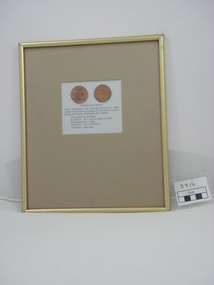 Echuca Historical Society
Framed Penny, Hopwood Penny
Reproduction done for Port of Echuca c.1980 heritage project. Henry Hopwood who founded Echuca in 1853, made the following charges for the use of his punt across the Murray River utiliising his own tokens. Charges - one penny for 2 sheep, six pence for 1 cow or head of cattle, ninepende for 1 horse, 18 pence for 1 horseman, "footmen" were free. 2 reproduction Hopwood Pennies, in frame with gold surrounds, pennies in centre of frameInscription BRIDGE HOTEL 1858 on one penny shows scene of Bridge Hotel and the other has inscripition HOPWOODS PUNT ECHUCA 1857 One Penny and scene of same. -
 Robin Boyd Foundation
Document - Script, Robin Boyd, The Flying Dogtor. Episode 16 A Burn in the Blue, 1963
Elvis Eagle, the 'bodgie bird', saved the plane and found The Flying Dogtor lying unconscious on the bank of a river after his frightening trip down an underground tunnel. Meanwhile, back at the Hilltop Hospital, his nurse Sister Spaniel, was still trying to cope with a strange disease that had attacked the bush creatures. Little did she know what awful adventures had befallen The Flying Dogtor.The Flying Dogtor" series was broadcast on Australian Television Network (later becoming the Seven Network) between February and April 1964 (see item D254 for schedule).Typewritten, carbon copy, foolscap, 2 pagesPage 1: handwritten correctionthe flying dogtor, robin boyd, crawford productions, manuscript -
 Peterborough History Group
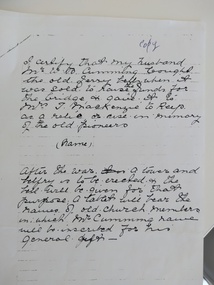
Letter - Statement regarding location of the old ferry call bell
When a ferry was the only way to cross the river, a bell was rung to call the ferryman. this letter explains that the bell was sold to raise funds for construction of the bridge. Mr W. B Cumming bought the bell and passed it to Mrs T. McKenzie. this statement was written and signed by Mrs W.B.Cumming and further states the expectation that a tower and belfry would be constructed, along with a plaque memorialising church members and Mr W.B Cumming.Significant because it specifies what happened to the Ferry call bell, which was very important when the ferry was the only way to cross the river. Photocopy of a statement by Mrs W. B Cumming explaining the history of the bellbells, ferry, curdies river, curdies river bridge, curdies river ferry, mr w.b. cumming, peterborough -
 Melbourne Tram Museum
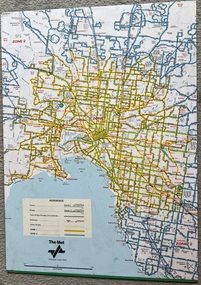
Map, The Met, "Tram and bus Routes showing destination numbers", June 1992
Titled "Tram Routes showing destination numbers". Map dated June 1992 and has been printed with The Met logo. Shows routes with route numbers, names of main destinations, roads, railway stations and rail lines, rivers, scales and Zones. Does not have the CBD insert. Same size as that of item 1099, a 1972 version. Type of map that was placed on the rear of the driver's doors of a W Class tramcar.Demonstrates a The Met produced map used in trramcars.Full colour map or poster printed on paper trimmed from original map and mounted on cardboard.Has some pen marks in the bottom left hand corner.trams, tramways, map, routes, the met -
 Ballarat Heritage Services
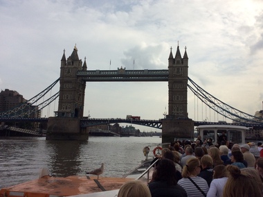
Photograph - Digital photograph, Dorothy Wickham, Tower Bridge, London, 2016, 19/09/2016
It took eight years, five major contractors and the relentless labour of 432 construction workers to build Tower Bridge. Two massive piers were sunk into the river bed to support the construction and over 11,000 tons of steel provided the framework for the Towers and Walkways. This framework was clad in Cornish granite and Portland stone to protect the underlying steelwork and to give the Bridge a more pleasing appearance.(http://www.towerbridge.org.uk/bridge-history/)tower bridge, london -
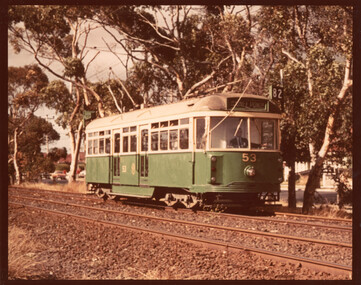 Melbourne Tram Museum
Photograph - VR class tram 53 River St Maribyrnong, c1975
Photograph of Victorian Railways built tram No. 53 which was sold to the MMTB following closure of the St Kilda - Brighton Beach line in 1959. Modified by the MMTB, as VR class tram No. 53 and generally used on the Moonee Ponds to Footscray route 82. This photo shows the tram in River St after being fitted with tail lights in Feb. 1973 and before being renumbered to tram 700 in Oct. 1976Yields information about VR class tram 53Colour print on Kodak paper with black borders. trams, tramways, river st, route 82, vr class, tram 53 -
 8th/13th Victorian Mounted Rifles Regimental Collection
Photograph - watering horses
See also 3089.86. Information with that photo gives an alternative provenance: 8th Light Horse Regiment watering horses at a Murray River lagoon, South Corowa NSW, September 1939; Wahgunyah Troop, C Squadron - this side of lagoon, Lieutenant J. Nott on grey horse in water. The number of horsemen would seem to exceed that of a single regiment so the Torquay description would seem more probable.Black and white photograph ( laminated ) of 8th, 13th,20th, and 4thLight Horse Regiments watering horses near Torquay Victoria , March 1940.Picture taken about March 1940 when the 13th Light Horse from Gippsland, the 8th Light Horse from Upper Murray, the 4th Light Horse from the Western Districts and the 20th Light Horse from the Goulburn Valley were in camp near Torquay. Mr Cappur Webb of Glendoxey, Seymour, a member of the 20th said the picture must have been taken during an exercise about five miles north of Torquay. “We used to water our horses in that lake”, he said." light horse, torquay, wwii, world war two, military, horses -
![Scene Near the Yarra Flats / [by] Nicholas Caire, circa 1876](/media/collectors/550653872162f11fb04854aa/items/577b4ae3d0cdd10948c7f0b6/item-media/577b4b3fd0cdd10948c81c16/item-fit-380x285.jpg) Kew Historical Society Inc
Kew Historical Society IncPhotograph, Anglo-Australasian Photographic Company, Scene Near the Yarra Flats, c. 1876
Nicholas Caire was born on Guernsey in the Channel Islands in 1837. He arrived in Adelaide with his parents in about 1860. In 1867, following photographic journeys in Gippsland, he opened a studio in Adelaide. From 1870 to 1876 he lived and worked in Talbot in Central Victoria. In 1876 he purchased T. F. Chuck's studios in the Royal Arcade Melbourne. In 1885, following the introduction of dry plate photography, he began a series of landscape series, which were commercially successful. As a photographer, he travelled extensively through Victoria, photographing places few of his contemporaries had previously seen. He died in 1918. Reference: Jack Cato, 'Caire, Nicholas John (1837–1918)', Australian Dictionary of Biography.An original, rare photograph from the series 'Views of Victoria: General Series' by the photographer, Nicholas Caire (1837-1918). The series of 60 photographs that comprise the series was issued c. 1876 and reinforced a neo-Romantic view of the Australian landscape to which a growing nationalist movement would respond. Nicholas Caire was active as a photographer in Australia from 1858 until his death in 1918. His vision of the Australian bush and pioneer life had a counterpart in the works of Henry Lawson and other nationalist poets, authors and painters.Views of Victoria (General Series) No.21 / ‘Scene near the Yarra Flats’ / Albumen silver photograph mounted on board.Inscription on reverse: ‘The scenery in the vicinity of the Yarra Flats is of a very varied character. In some places the River winds its way through flat open country, with scarcely a shrub on its banks; and in others the scenery is of the wildest description. The stream being impeded in its course by fallen timber, is not so rapid here as at other places. The present illustration is a characteristic one of the above place.’nicholas caire, australia - landscape photography -
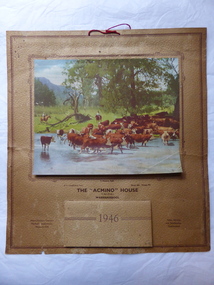 Warrnambool and District Historical Society Inc.
Calendar
This calendar has been distributed as a advertising item for Earl’s agricultural machinery and oil depot. The business was situated at the corner of Lava and Kepler Streets in Warrnambool. The name, Acmino’ stood for Allis-Chalmers, Mitchell’s Implements, Neptune Oils’. Distributing calendars at Christmas time for the following year was, and still is, a popular advertising tool for businesses. This calendar is of minor interest as an example of the use made by businesses in the 1940s of calendars as advertising tools. It also has a local Warrnambool connection, the agricultural machinery business of F. Earl. This is a 1946 calendar with a buff-coloured sheet of crinkled paper with a brown border. It has a coloured photograph of two men droving cattle near a river and it ispasted on to the paper with a brown border around the photograph. The calendar for 1946 is printed on to the paper and also in monthly sheets pasted on to the paper on top of each other. The printing on the calendar is brown. On the back of the calendar is written in black ink, ‘French Bros’. The calendar has a red piece of string at the top for hanging the calendar up on a wall or cupboard. The calendar is torn at the edges and somewhat stained.‘With Compliments from the “Acmino” House, F.Earl (Prop.)Warrnambool Phone 484 Private 75’ ‘Allis-Chalmers Tractors Mitchell’s Implements Neptune Oils’ ‘Sales, Service and Satisfaction Guaranteed’ ‘French Bros’ ‘acmino’ house, warrnambool, f. earl, history of warrnambool -
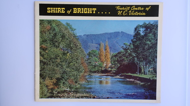 Kiewa Valley Historical Society
Brochure - Shire of Bright, Shire of Bright Tourist Centre of N.E. Victoria, Pre 1966
Bright and the surrounding towns were developing a large tourism industry which the Shire of Bright continues to promote, encouraging tourists to visit throughout the year. This high quality brochure has magnificent photos with a map showing the area and the distance (in miles) from the centre - the township of Bright.This brochure is promoting the Shire of Bright encouraging tourism in the area. This is important for the Shire as tourism is the main industry for the Shire. It is interesting to see how tourism has changed (or not) in the area.14 pages on glossy paper including colored and black and white photos. The front cover has the title at the top with yellow print on black background. Below the title is a large colored photo of a river, autumn trees and mountain. The back cover is a large colored photo of a man amongst the snow gums in the snow. The towns covered are Bright, Wandiligong, Eurobin, Mt Buffalo, McKay Creek Power Station, The Kiewa Hydro Electric Scheme, Mt Beauty, Kiewa, Bogong including tourist destinations in these areas and their surrounds.tourism; mt beauty; the kiewa valley; bright shire -
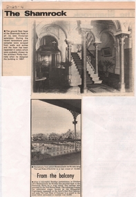 Bendigo Historical Society Inc.
Newspaper - NEWSPAPER CUTTINGS SHAMROCK HOTEL, Unknown
Double Sided Newspaper Clippings on the history of The Shamrock Hotel in Bendigo, Victoria Australia. (Front of first clipping) the ground floor foyer in all of its late Victorian splendour. (Back of first clipping) the fanlight above the french doors opening out on to the first floor balcony. The delicate leadlight frames a circular river landscape painted on the glass. (Front of second clipping) the Shamrock Hotel Balcony where in October 1874 Mademoiselle de Murska performed The Last Rose of Summer to a rapt crowd of 10,000.bendigo, history, shamrock hotel