Showing 11140 items
matching planning
-
 Bendigo Historical Society Inc.
Document - LONG GULLY HISTORY GROUP COLLECTION: PLAN FOR PLAQUE
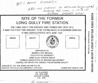
Copy of a plan for the plaque for the Site of the Former Long Gully Fire Station. Plan has the Country Fire Authority Victoria Logo and three spaces for badges. It also has when the Long Gully Fire brigade was formed and when it was deregistered. Also mentioned is the supporters: Bendigo Fire Brigade, Country Fire Authority, Long Gully History Group, Cornish Association of Bendigo and District and the Central Victorian Fire Service Presentation Society. Unveiled by The Hon Andre Haermeyer MP and Minister for Police and Emergency Services on Sunday 20th August 2000. Plaque to be made by A1 Plaques.bendigo, history, long gully history group, the long gully history group - plan for plaque, bruce furnell, long gully fire station, long gully fire brigade, country fire authority, bendigo fire brigade, long gully history group, cornish association of bendigo and district, central victorian fire service presentation society, the hon andre haermeyer mp, a1 plaques -
 Bendigo Historical Society Inc.
Document - CHRISTMAS REEF GOLD MINING CO. COLLECTION: PLAN OF MINE
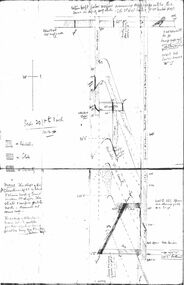
Hand drawn plan of mine, showing spurs, slate, lava. Christmas Reef shaft and Great Western shaft drawn. Notations in pencil. On left hand side 'Memo: the shaft of the Christmas Reef Co is about 5 chains north of Great Western Cos shaft. The strata and surface pitch north, assumed at same rate. The working of Allingham and Moore's Trib Co are taken from their reports in Bendigo Advertiser May 1872 to May 1873. Jas Down Mgr' Scale on plan 20 ft to 1 inch Legend shows sandstone, slate and quartz.Bendigo Advertiserbendigo, mining, christmas reef gold mining -
 Kew Historical Society Inc
Plan - Subdivision Plan, Myrtle Park Estate, Emerald, 1915
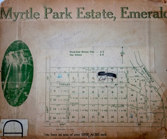
This subdivision plan for the ‘Myrtle Park Estate’ relates to land sales in Emerald, Victoria, rather than to the subdivision of the same name in East Kew (1913-16). The subdivision in Emerald included 32 one-acre lots facing Torley Road, Government Road (now Rawhiti and Wong Hee Roads) Beaconsfield Road (now Old Beaconsfield Road). On the plan, an unnamed creek flows through allotments 8-12 on the east side of the Estate. The photograph of a waterfall and the advertised price of Day Return and Weekend Return Fares provide an indication of who the prospective purchasers were likely to be.subdivision plans - emerald, myrtle park estate, torley road -- emerald (vic.) -
 University of Melbourne, Burnley Campus Archives
Plan, 25 Wakanui Street, 1996
Plans for a garden at 25 Wakanui Street [Northcote] by Holmes Design. (1) Point Location Data showing plumbing fixtures. (2) Tracing paper and paper copies Dwg No 13 Site Inventory & Analysis 4/6/96. Scale 1:100. (3) Coloured tracing paper and paper copies, Dwg No 15 Preliminary Plan 6/6/96. Scale 1:100. (4) Tracing paper and paper copies Dwg No 16 Section View Backyard 6/6/96. Scale 1:50. (5) Photocopy of Certificate of Title and Sewerage.wakanui street, holmes design, northcote, garden design -
 Melbourne Tram Museum
Document - Report, Yan Gaoulil, Conservation Management Plan for The Tramway Signal Cabin, Apr. 2017
Report - 28 A4 pages, double sided stapled in the top left hand corner titled "Conservation Management Plan for The Tramway Signal Cabin, Waiting Shelter and Conveniences at Swanston Street and Victoria Street Melbourne". Prepared by Yan Gaoulil as part of an assignment when undertaking Conservation Management Plan studies. Provides a introduction to the study, history, description, significance, Key Issues, Policy, implementation for the conservation of the building. Includes a Bibliography and Appendices. A second set of documents, five pages stapled in top left hand comer, lists correspondence between the Author and the Museum commencing Dec. 2016.trams, tramways, waiting shelters, franklin st, conservation planning, signal box, swanston st -
 Melbourne Tram Museum
Document - Research Notes, H. S. McComb, The Age, "Information searched at MMBW from 40' to 1 inch plans showing Essendon Tramways" & "A Women Drove the First Tram", c1958
Set of papers, handwritten concerning the history of Essendon electric system, track layouts, dimensions, field book notes, plans, sketches of Trackwork prepared by A H McC? - dated 28/8/1958. "Information searched at MMBW from 40' to 1 inch plans showing Essendon Tramways" Includes a copy of a newspaper cutting from The Age 11/10/1956, titled "A Women Drove the First Tram". Items 2027 to 2030 and 1309 copy 2 contained within box 72.3 in a brown folder marked "Historical Data regarding Essendon Tramways and their services to the City"trams, tramways, essendon, saltwater river, keilor rd, reports, essendon depot, nmetl, moonee ponds, mmbw, opening -
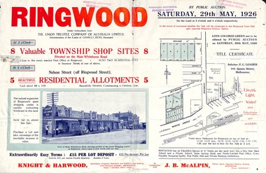 Ringwood and District Historical Society
Flyer, Township Shop Sites and Residential Allotments Sale By Public Auction, Ringwood, Victoria - 1926
Advertisement for eight township shop sites and five residential allotments for sale by Public Auction on the land in Ringwood on Saturday, 29th May, 1926, with location map, and summary of local features and services. Locality plan highlights sites for auction in Nelson Street, Seymour Street and Whitehorse Road. (Agents) Knight & Harwood, 315 Collins Street, Melbourne, Phones 10615, 10616 Central, in conjunction with J.B. McAlpin, Estate Agent, Opposite Railway Station, Ringwood, Phone Ringwood 7. -
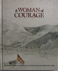 Robin Boyd Foundation
Book, Marc Serge Riviere, A Woman of Courage. The Journal of Rose de Freycinet on her Voyage around the World 1817-1820, 1996
HardcoverNewspaper Clippings (1) "Into the Pacific", a book review of this book by Alan Frost for The Weekend review 25-26 Jan 1997; (2) "Plan steers a steady course" on the NGV redesign, The Age 12 May 1997. Also a thank you card to Patricia and John from Noel.walsh st library -
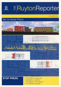 Ruyton Girls' School
Magazine, William Troedel & Co, Ruyton Reporter, 2004
The Ruyton Reporter (formerly known as Ruyton Reports) captures the essential Ruyton Girls' School experience for the broader school community. It has been produced since 1986.The record has strong historic significance as it pertains to one of the oldest girls' school in Victoria, Australia. Ruyton was founded in 1878 in the Bulleen Road, Kew, home of newly widowed Mrs Charlotte Anderson (now High Street South). Thus, the record can be used as a reference example for research into Victorian school history. It also gives insight into the types of activities and events undertaken at Ruyton Girls' School during the period of its production. The record's significance is further enhanced by its exceptionally well-documented provenance, having remained the property of Ruyton Girls' School since its production.Colour publication printed on paper with staple binding. 20 pages.Front Page: PRINT POST APPROVED PP 341999 000226 / R / RECTE ET FIDE LITER / THE RUYTON REPORTER / AUTUMN 2004 / We've Made Plans / STOP PRESS: VCE 2003 a class act / spotlight on drama / musicians in the swing / our brilliant old girls /ruyton girls' school, ruyton, school, students, newsletter, ruyton reports, ruyton news, kew, victoria, melbourne, girls school -
 Eltham District Historical Society Inc
Slide - Photograph, Eltham Shire Council, Plan of Subdivision, Crown Allotment 8, Section 8A, Parish of Nillumbik,County of Evelyn, 1969
... planning ...35mm colour positive transparency blue Agfacolour Service plastic mountC1, Pain, Sibbel and Carter, Research-Warrandyte Road, North Warrandyte, 4 August 1969carter, infrastructure, map, north warrandyte, pain, parish of nillumbik, plan of subdivision, planning, research-warrandyte road, sibbel, subdivison lots -
 Eltham District Historical Society Inc
Slide - Photograph, Eltham Shire Council, Plan of Subdivision, Part of Crown Allotments 5 & 6, Section 10, Parish of Nillumbik, County of Evelyn (Foster Road, Eltham East), 1969
... planning ...35mm colour positive transparency blue Agfacolour Service plastic mountC5(a) DU (Vic) D/L Foster Road, Eltham East, 4 August 1969infrastructure, map, planning, subdivison lots, abersham court, ancona close, eltham east, floriston grove, foster road, frank street, gladwyn court -
 Ringwood and District Historical Society
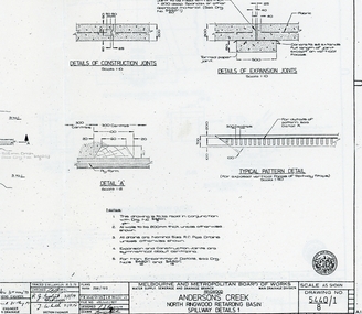
Plan - plans, Metropolitan board of Works, Metropolitan Board of Works plans of North Ringwood retarding basin, energy dissipaters and spillway details, 1979, 31-May-79
Plans made by the Metropolitan Board of Works in May 1979 detailing 1. energy dissipaters for existing drains at the North Ringwood Retarding basin. 2 spillway details2 A3 pages with drawings of Melbourne Metropolitan Board of Works of the North Ringwood retarding basin -
 Bendigo Military Museum
Document - PLANNING GUIDE, SUPPLIES, ARMY
1. & 2. Tabulated planning guides for daily use of Class 3, Sup (Tonne). Part of the "Kevin John Herdman" No. 397661, collection. See catalogue No. 5942P.1. & 2. Quarto sized multi page documents with pages stapled in top LHC. Holes punched on LHS for placement in a ring binder. printing on one side of each page in black.kevin john herdman, army, planning guide, supplies -
 Eltham District Historical Society Inc
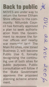
Newspaper - Newspaper Clipping, Diamond Valley Leader, Back to public, Diamond Valley Leader, 22 November, 2006
Nillumbik Shire Council plans to re-zone the former Eltham Shire Office site and Eltham War Memorial from Buisness 2 to Public Use 6895 main road, eltham, eltham shire office, eltham war memorial, nillumbik shire council, re-zoning -
 Bendigo Military Museum
Newspaper - NEWSLETTER, 7th AUSTRALIAN DIVISION ASSOCIATION, 7 Div ASC Association, 7 Aust DIV ASC Newsletter 1995 Edition, 1995
In the newsletter are numerous subects. Vale section from WW2 incudes Ron Barassi, There are plans for the ANZAC March and VP Day. There is a Äustralia Remembers page 1945 - 1995".This newsletter is composed of 7 sheets of A4 paper. They are printed on both sides. It has texts, photos, cartoons and Unit symbols. The news letter was for the 1995 time. The sheets are stapled in top left corner.Nil7 division, ww2, army service corp -
![Newspaper Clipping - Digital Image, Dunvegan estate will be 'ideal' 1973 [Macleod], 21/08/1973](/media/collectors/4f729f5697f83e03086015b8/items/5eb3d35f21ea670b942b615e/item-media/5eb3d3bd21ea670b942bcc1d/item-fit-380x285.jpg) Greensborough Historical Society
Greensborough Historical SocietyNewspaper Clipping - Digital Image, Dunvegan estate will be 'ideal' 1973 [Macleod], 21/08/1973
In 1973, the planning for the Dunvegan Estate in North Macleod was well under way, with some residential blocks owned and developed by the Housing Commission of Victoria (later the Ministry of Housing).News clipping, black and white text.dunvegan estate macleod, north macleod, housing commission of victoria, ministry of housing victoria -
 Greensborough Historical Society
Pamphlet, Victorian Government, Environment: EES study update, 2018_09
Forms part of the EES study update for planning approval process for the North East Link. This volume covers Ecology (flora, fauna and aquatic), groundwater and surface water6 p., col. photographsnorth east link -
 Greensborough Historical Society
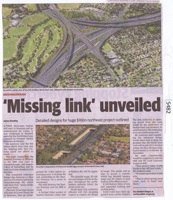
Newspaper Clipping, Diamond Valley Leader, 'Missing Link' unveiled, 12/09/2018
A twin three lane tunnel will start in Rosanna and go underground for 5.3km, it was confirmed in detailed plans for the North East Link released by Premier Daniel Andrews on Sunday.News article 1 page, black text and colour image .north east link, daniel andrews, rosanna -
 Greensborough Historical Society
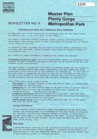
Newsletter, Melbourne & Metropolitan Board of Works, Master Plan Plenty Gorge Metropolitan Park, 1991_06
The Parks Division of the Board was responsible for the preparation of a Master Plan for the management of the Plenty Gorge Metropolitan Park, comprising privately owned land and land owned by the Board and councils.The creation of the park by the Victorian government, to be managed by the Board of Works, guaranteed public access to a large area of land adjacent to the Plenty River Gorge.2p. newsletter, black ink on blue paperNewsletter No. 6plenty gorge park, plenty river -
 Orbost & District Historical Society
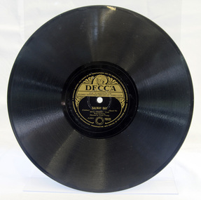
gramophone record, 1949
Galway Bay was a hit around the world for the American singer Bing Crosby in the late 1940s. Crosby was very popular in Australia and had planned to visit Australia in 1949.The phonograph disc record was the primary medium used for music reproduction until late in the 20th century, replacing the phonograph cylinder record—with which it had co-existed from the late 1880s through to the late 1920s. Records were still the most popular media even when new formats such as compact cassette were mass-marketed. By the late 1980s, digital media, in the form of the compact disc, had gained a larger market share, and the vinyl record left the mainstream in 1991. This item is representative of the music popular in the mid 20th century.Double sided black disc with a single central hole. A side is Galway Bay. B side is My Girl's An Irish Girl. Both are vocal with orchestra by Bing Crosby. On the central label is Y6121 and detailed information of the maker, Columbia Gramophone Company (Aust)., in gold print on black background.Pressed - WL4583T20Aphonogram-record vinyl crosy-bing music-irish -
 Eltham District Historical Society Inc
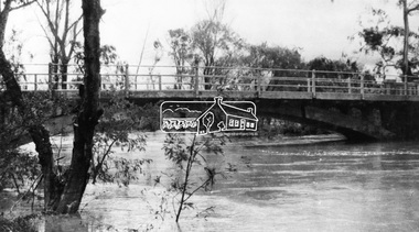
Negative - Photograph, Diamond Creek floodwater at Monash Bridge, Hurstbridge, Dec. 1934
The historic 1934 flood of the Diamond Creek and Yarra River following the storms of 29-30 November set the levels for future planning with respect to flood water rise.This photo forms part of a collection of photographs gathered by the Shire of Eltham for their centenary project book,"Pioneers and Painters: 100 years of the Shire of Eltham" by Alan Marshall (1971). The collection of over 500 images is held in partnership between Eltham District Historical Society and Yarra Plenty Regional Library (Eltham Library) and is now formally known as the 'The Shire of Eltham Pioneers Photograph Collection.' It is significant in being the first community sourced collection representing the places and people of the Shire's first one hundred years.Digital image 4 x 5 inch B&W Negshire of eltham pioneers photograph collection, hurstbridge, 1934 flood, floods, monash bridge, diamond creek (creek) -
Moorabbin Air Museum
Document (Item) - F/A-18 Program Report Regarding Process Control Training, F/A18 Program - A.I.P. Technical Training Report No. NTF16-AF182
Report relates to R. Pettis' (Chief Chemist) visit, regarding the F/A-18. Page stapled to the front, indicating the report is for Mr A Nash, Manager of N.T.F. Planning. -
 Robin Boyd Foundation
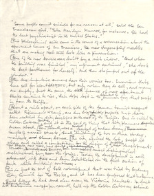
Document - Manuscript, Robin Boyd, (some people commit suicide …..)
Personal reflection of apartment tower developments in San Francisco - Golden Gateway Centre and Ghirardelli Square. A critique of their urban planning, particularly treatment of the ground plane and landscaping.Handwritten, quarto, 3 pages.apartment towers, urban planning, san francisco, golden gateway centre, ghirardelli square, robin boyd, manuscript -
National Wool Museum
Book, Belgenny Farm
"Belgenny Farm" - Department of Planning, Sydney, 1988. History of the buildings of Belgenny Farm, part of the Camden Park Estate which was formerly owned by John and Elizabeth Macarthur.merino sheep - history sheep breeding - history sheep stations - history, macarthur, mr john macarthur, mrs elizabeth, belgenny farm, nsw, camden park estate, merino sheep - history, sheep breeding - history, sheep stations - history -
 Surrey Hills Historical Society Collection
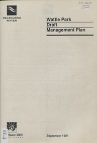
book, Wattle Park Draft Management Plan, Sept 1991
This draft management plan has been developed after consultation with park users, and specific interest groups. It takes into account the findings of market research and community liaison.An A4 sized bookletOn top RH corner of cover: "JF Hall/own"wattle park (box hill, vic) - planning, parks - victoria- box hill- management, gardiner's creek, anniversary trails, vegetation, wattle park chalet, wattle park golf course, land use, melbourne water, riversdale golf course, national trust, riversdale road, surrey hills -
 City of Kingston
Pamphlet - Colour, Stillwell and Co, The Hill Estate Highett Great Subdivisional Auction Sale, 1917
Sales plan for land in the suburb of Highett, bounded by Point Nepean Road and incorporating Sandford Street, Turner Road, Alfred Street, Peace Street and Tennyson Street. .The developing urban area of Highett within the City of Kingston. This land sale pamphlet illustrates the subdivision of land within the municipality and the changing demographic of the district as new houses are constructed.Colour pamphlet advertising subdivisional auction sale of the Hill Estate Highett. Incorporates a map of the estate bordered by Point Nepean Road and encompassing Sandford Street, Turner Road, Alfred Street, Peace Street and Tennyson St. Handwritten in grey pencil on reverse: Hill Street / Jamieson Handwritten in blue pencil on reverse: The Hill Estate Handwritten in blue pencil on subdivision map: [tick] [on majority of properties marked on map]highett, land sales, estate -
 City of Kingston
Pamphlet - Colour, W. H. Wood Estate Agent, Realising sub-divisional auction sale Bentleigh Park Estate, Bentleigh, 1920
Sales plan for land in the suburb of Bentleigh, bounded by Centre Road, and incorporating subdivisions on either side of Elizabeth Street (Wheatley Road), Oak Street and Beech Street.The developing urban area of Bentleigh within the City of Kingston. This land sale pamphlet illustrates the subdivision of land within the municipality and the changing demographic of the district as new houses are constructed close to infrastructure.Colour pamphlet advertising a realising sub-divisional auction sale of the Bentleigh Park Estate, Bentleigh. Incorporates a map of the estate bordered by Centre Road, and including Elizabeth Street (Wheatley Road), Oak Street and Beech Street.Hand drawn in grey pencil: a small square on subdivision 33 Hand drawn in grey pencil: a small square incorporating a cross on subdivision 24 Hand written in black ink on reverse: Bentleigh Park / Estate / Ward late Andersonsland sales, estate, bentleigh -
 University of Melbourne, Burnley Campus Archives
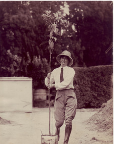
Newspaper - Newspaper Cutting, The Age, Burnley students go back to help dig up history, 1985
Article about a reunion planned as a forerunner for the 1991 Centenary celebrations. Quotes from Edna Walling, Grace Fraser. Donated by Ella Chalmers (née Fry) 1928Article in "The Age" 03.12.1985 by Anne Latreille Female student carrying a tree in a tin container. The student is wearing boots, gaiters and jodhpurs. The original photograph was lent to the Archives by Anne Latreille. It was used as an illustration for an article in, "The Age," in 1991. It was used as an illustration in, "Green Grows Our Garden," A.P. Winzenried. See B91.192.anne latreille, ella chalmers (nee fry), centenary, student reunion, edna walling, grace fraser, ella fry, students working outside -
Bialik College
Document (Sub-series) - Architect Ron Unger's papers relating to Auburn Road campus
development, construction, buildings, 1980sdevelopment, construction, buildings, 1980s -
Bialik College
Document (Sub-series) - Bialik tuckshop, 1995
1990s, shuk1990s, shuk