Showing 10832 items
matching maps
-
 Canterbury History Group
Map - Canterbury Subdivisions
A collection of 6 maps with notations showing the names and dates of land subdivision in Canterbury and surrounding suburbs.canterbury, logans estate, shrublands estate, claremount park estate, arklow hill estate, griffin estate, monomeath estate, mont albert park estate, great railway estate, grange estate -
 Camberwell Historical Society
Document, Lovell Chen Architects and Heritage Consultants, Camberwell Junction Heritage Review 2008, 2008
camberwell, heritage, boroondara -
 Ringwood RSL Sub-Branch
Book, Word War II in photographs, 1984
Hard cover with dust cover. 192 pages containing text, maps and black and white photosKen R ? -
 Wodonga & District Historical Society Inc
Booklet - Hume and Hovell Centenary Celebrations Booklet, 1924
This souvenir was created as part of the celebrations to commemorate the journey of Hume and Hovell from New South Wales (Near Yass) to Port Phillip Bay, passing through the site of modern day Albury and Northeast Victoria.A small booklet printed for celebrations to commemorate the centenary of the journey of Hume and Hovell, including maps and advertising.fictionThis souvenir was created as part of the celebrations to commemorate the journey of Hume and Hovell from New South Wales (Near Yass) to Port Phillip Bay, passing through the site of modern day Albury and Northeast Victoria.hume & hovell, hume & hovell centenary -
 Wodonga & District Historical Society Inc
Book - Table Top 1824 - 1984, Merrick L Webb
This publication was compiled for the Centenary celebrations of the Table Top school in 1984. Known by the Aborigines as Mullyan-argina, or breeding place of eagles, the flat topped hill attracted the attention of Hume and Hovell's expedition in November 1824 and Hamilton Hume named Battery Mount. Later on, when the Mitchell family acquired the run they named it Table Top. The book contains detailed information about the district and pioneer families who contributed to its development.A paperback publication of 80 pages including photographs and maps compiled by the Table Top History Committee.This publication was compiled for the Centenary celebrations of the Table Top school in 1984. Known by the Aborigines as Mullyan-argina, or breeding place of eagles, the flat topped hill attracted the attention of Hume and Hovell's expedition in November 1824 and Hamilton Hume named Battery Mount. Later on, when the Mitchell family acquired the run they named it Table Top. The book contains detailed information about the district and pioneer families who contributed to its development.table top nsw, hume & hovell, the mitchell family, table top pioneers -
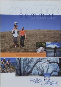 Falls Creek Historical Society
Booklet - Falls Creek Summer in the High Country 2002 - 2003
A part of a yearly marketing and information program to promote activities in the Falls Creek area outside of the winter season. This booklet promotes a wide range of activities and venues in Falls Creek and surrounding district.This item is important as it documents seasonal activities at Falls Creek Alpine area and how they have been promoted. An A4 sized marketing booklet, including images, maps and advertising information printed on glossy paper.falls creek tourism, falls creek victoria, falls creek summer -
Southern Sherbrooke Historical Society Inc.
Map - photocopy, Woodcock & McCormack, civil engineers & architects & surveyors, The Major Estate, Belgrave
A photocopy taken from the original land sale map provided to the society through Karel Coxell of Stockdale & Leggo. The original maps are stored in large bound account books and were originally the propert of McNally Real Estate. The books are held (in 22 A3 sheets. Shows The Serpentine between Government Rd (now Sandells Rd) and Government Rd(now Terrys Ave), Belgrave. Arrows to Belgrave, Sherbrooke Falls, Main Rd and store.land sales, advertisement, real estate subdivision, t. mahoney -
Southern Sherbrooke Historical Society Inc.
Map - photocopy
A photocopy taken from the original land sale map provided to the society through Karel Coxell of Stockdale & Leggo. The original maps are stored in large bound account books and were originally the propert of McNally Real Estate. The books are held (in 2A3 photocopy of plan of survey of part of Crown Allotments 20 & 21, section C, parish of Narre Worran, County of Mornington. Clements Ave and environs in Belgrave Heights"Villette Estate" in top LH corner, "Locality Plan" in bottom LH corner, "Not in sale" written on one block and crossed out. All handwritten in pencil on original. "Colby Drive " and "Verona Street" added in pencil to copy.land sales, advertisements, subdivision -
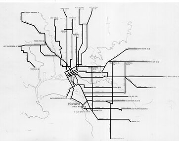 Melbourne Tram Museum
Photograph - Set of 3 Black & White Photograph/s, Melbourne & Metropolitan Tramways Board (MMTB), c1940
Series of 3 black and white photographs of MMTB tram route maps. .1 - map showing route numbers, terminus names, and major streets - early 1970's after route renumbering that stopped using routes like 4A. .2 - similar presentation but with a different style of showing the routes - double parallel lines. .3 - photograph black and white of an early 1950's map, showing Latrobe St, bus routes, but Bourke St still as a bus route. Shows Point Ormond and Footscray lines. Shows guest houses - see Reg Item 3720 for the actual map.trams, tramways, melbourne, map, tram & bus services, all night services, mmtb, guest houses -
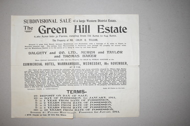 Warrnambool and District Historical Society Inc.
Documents (2), 1 1915 .1 1910
These documents come from a collection of material from the Baulch families of Dunmore and Rose Park estates in Western Victoria in the Macarthur district. They concern the sales of the Green Hills Estate (1910) and the Olangolah estate (1915) near Woolsthorpe. Both were offered for sale by the owner, Colin Tulloh. The properties bordered on Baulch property belonging to Stan Baulch (1897-1980) and hence this is the reason for their being included in Baulch estate material. These items are of minor interest and will be useful to researchers as they show the sizes and some owners of some early 20th century Western District properties. .1 A single sheet of white paper with a map or plan of a property and black printing. The paper is creased and torn slightly at the edges. 2 A single sheet of white paper with a map of a property on one side and black printing on the other. The paper is creased and torn at the edges. The Green Hills Estate Western District Estate ‘Olangolah’ western district estates, warrnambool, olongolah estate, green hills estate -
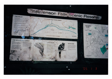 Marysville & District Historical Society
Photograph (item) - Colour photograph, 03-01-2005
Shows the sign at the Steavenson Falls Scenic Reserve.Shows the sign at the Steavenson Falls Scenic Reserve. This sign was destroyed in the 2009 Black Saturday bushfires. The Steavenson Falls is named after the Victorian Assistant Commissioner of Roads and Bridges, John Steavenson who arrived in Victoria in the early 1860s.'05 1 3 3.01.05. Marysville (from Helga Walsh)steavenson falls, steavenson falls scenic reserve, mountain forest, lyrebird, bobuck, mountain brushtail possum, marysville, victoria, john steavenson, 2009 black saturday bushfires -
Bendigo Historical Society Inc.
Map - CAMPBELL COLLECTION: BENDIGO AND DISTRICT MAPS, 8-2-29
Map. Bagshot, Parishes of Wellsford, Ellesmere, and Bagshot. Huntly 4 miles, Fosterville 3 miles. Total area 5037 acres, Prepared in W.P.B. from A.C.L and D.B. Plans, by W.J.Galbraith 8-2-29. (number 382 in map cupboard 1).W.J.Galbraithmap, bendigo, agricultural lands -
Bendigo Historical Society Inc.
Map - CAMPBELL COLLECTION: BENDIGO AND DISTRICT MAPS, 30-1-29
Map. Ellesmere, Parish of Ellesmere, scale 20 chains to 1 inch. Total area 3926 acres. Prepared in W.P.B. from A. and P. Plans, by W.J. Galbraith, 30-1-29, to Bendigo along Fosterville. (number 381 in map cupboard 1)W.J.Galbraithmap, bendigo, agricultural lands -
Bendigo Historical Society Inc.
Map - CAMPBELL COLLECTION: BENDIGO AND DISTRICT MAPS, 16-5-29
Map. Egerton, Parishes of Egerton and Whirrakee. Scale 20 chains to 1 inch. Total area 5401 acres. Prepared in W.P.B. from A. and C.L. Plans by W.J.G. 16-5-29. To Rochester 12 miles. (number 366 in map cupboard 1)W.J.G.(W.J.Galbraith)map, bendigo, allotments -
Bendigo Historical Society Inc.
Map - CAMPBELL COLLECTION: BENDIGO AND DISTRICT MAPS, 8-2-29
Map. Bagshot, Parishes of Wellsford, Ellesmere and Bagshot. Scale 20 chains to 1 inch. Total area 5037 acres. Prepared in W.P.B. from A.C.l. and D.B. Plans, W.J. Galbraith, 8-2-29 (number 353 in map cupboard 1)W.J.Galbraithmap, bendigo, agricultural lands -
Bendigo Historical Society Inc.
Map - CAMPBELL COLLECTION: BENDIGO AND DISTRICT MAPS, 12-2-29
Map. Axedale, Parishes of Ellesmere and Axedale. Scale 20 chains to 1 inch. To the west is Wellsford. Total area 4156 acres. Prepared in W.P.B. from A and P plans by W.J. Galbraith 12-2-29. (number 352 in map cupboard 1)W.J.Galbraithmap, bendigo, agricultural lands -
Bendigo Historical Society Inc.
Map - CAMPBELL COLLECTION: BENDIGO AND DISTRICT MAPS, 1929
Map. Campaspe, Parish of Kimbolton. Total area 4117 acres. Campaspe River, Kimbolton. Scale 20 chains to 1 inch. Prepared in W.P.B. form Parish and Assessment Plans. G.W.L. 9-4-29. (number 351 in map cupboard 1)map, bendigo, allotments -
 Bendigo Historical Society Inc.
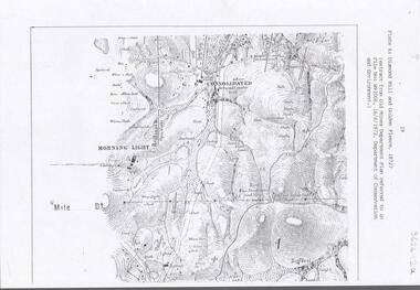
Document - DIAMOND HILL AREA MAP
Map copy, 2 pages, from 'Old Mines Department Plan, Dept of Conservation and Environment File No W91006, 16.6.1972' Map shows Golden Gully area with 'Town and Country Hotel' on north side and further south, with shafts and mine names marked.bendigo, mining, diamond hill -
 Bendigo Historical Society Inc.
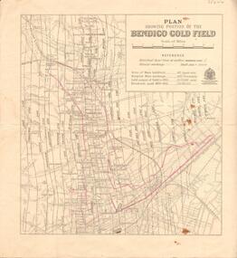
Map - BENDIGO GOLD FIELD - MAP OF PORTION OF THE BENDIGO GOLD FIELD
Map showing portion of the Bendigo Gold Field showing Alluvial working, shaft sites , streets and lines of reefs.Department of Mines, Victoria. Many mines, lines of reefs and gullies are on the map. Blue Royal Historical Society of Victoria Bendigo Branch stamp on the back.document, bendigo gold field, department of mines, lines of reefs, gullies, mines -
Bendigo Historical Society Inc.
Map - DERBY : COUNTY OF BENDIGO, 1959
Map. Derby, County of Bendigo, Bridgewater, Inglewood, Tarnagulla, Woodstock, Leichardt, Loddon River. By authority A.C. Brooks, Government Printer, Melbourne. Drawn and reproduced at the Department of Lands and Survey, Melbourne. 1959. Price 2/-. (number 54 in map cupboard 1)A.C. Brooks, Government Printer, Melbourne.map, bendigo, derby -
Bendigo Historical Society Inc.
Map - BAMAWM : COUNTY OF BENDIGO, November 1954
Map. Bamawm, County of Bendigo, Pannoobamawm, Turrumberry, Millewa, Ballendella. By authority W.M. Houston, Government Printer. Drawn and reproduced at the Dept of Lands and Survey,Melbourne, Victoria. November 1954. Price 5/- per sheet. (number 51 in map cupboard 1)W.M. Houston, Govt. Printermap, bendigo, bamawm -
Bendigo Historical Society Inc.
Map - YALLOOK : COUNTY OF BENDIGO, 30-1-28
Map. Yallook, County of Bendigo, L4942, Talambe, Tandarra, Neilborough, Yarraberb, Salisbury, Pompapiel. Drawn and reproduced at the Department of Lands and Survey, Melbourne, Victoria. 30-1-28. H.J. Green, Govt. Printer, Melbourne. (number 18 in map cupboard 1)H.J. Green, Govt. Printer.map, bendigo, yallook -
Bendigo Historical Society Inc.
Map - HAWKESTONE, COUNTY OF BENDIGO, December 1953
Map, Hawkestone, County of Bendigo, County of Talbot, Sutton Grange, Redesdale, Lyell, Myrtle Creek, By authority W.M.Houston, Government Printer. Drawn and Reproduced at the Dept. of Lands and Survey, Melbourne, Victoria.December 1953. Price 5/-. (number 98 in map cupboard 1)W.M.Houston, Governmemt Printer.map, bendigo, hawkestone. -
Bendigo Historical Society Inc.
Map - COSTERFIELD : COUNTY OF BENDIGO, 31-10-12
Map. Costerfield, County of Bendigo, County of Dalhousie, Dargile, Moorambool West, Warrowitue, Heathcote, Town of Costerfield. Photo-Lithographed at the Department of Lands and Survey, Melbourne, by W.J .Butson 31-10-12 price 1/-. (number 93 in map cupboard 1)W.J. Butsonmap, bendigo, costerfield -
 Ballarat Tramway Museum
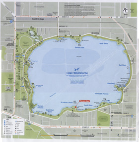
Map, City of Ballaarat, Lake Wendouree, 2010
Colour printed map of Lake Wendouree and surrounding streets showing walking paths, roads, tram, bus and rail lines and other features. Used in the large maps placed around the Lake c2009. Printed on an A3 size sheet. Two copies held.trams, tramways, map, lake wendouree, wendouree parade -
 Otway Districts Historical Society
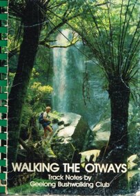
Book, Geelong Bushwalking Club Inc, Walking the Otways, November 1986
The Otways area of Victoria, at the time of writing, was an underused area for bushwalking. In the past, people have considered these ranges unsuited for walking because of the thick forest cover, cold and muddy conditions for much of the year, and the steep slopes. Some of the perceived difficulties are actually attractions and that it is possible to enjoy them with a forward planning and up-to-date information to guide the walker.The Geelong Bushwalking Club have included some useful but brief articles on basic aspects of bushwalking.Walking the Otways. Track notes compiled by the Geelong Bushwalking Club. Graeme Allen (ed.); John Van Gemert (maps, photographs). 1st ed. Geelong Bushwalking Club; Geelong (Vic); November 1986. 148 p.; illus, maps. Soft cover.otways; bushwalking; -
 St Patrick's Old Collegians Association (SPOCA)
Photograph - Buildings, SICG, Loans 3
-
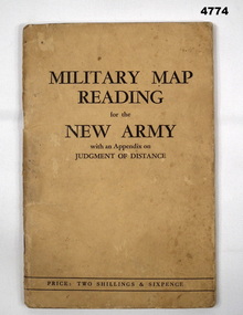 Bendigo Military Museum
Booklet, CAPT W STANLEY LEWIS et al, Military Map Reading for the New Army, 1941
Military Map Reading for the New ArmyCardboard Covered booklet. This has 64 pages with illustrations. It is bound with 2 staples.Military Map Reading for the New Armymap reading, judging distance -
Lakes Entrance Regional Historical Society (operating as Lakes Entrance History Centre & Museum)
Book, A Study of Land in Catchment of the Gippsland Lakes Vol 2, 1992
504 printed pages, a map is included inside front coverBlue cardboard cover with title printed in gold, title also printed on spine in golddocuments, reports -
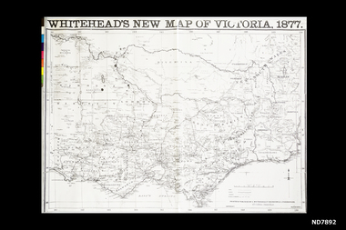 Whitehorse Historical Society Inc.
Map, Whitehead's New map of Victoria, 1877
A map of Victoria produced in 1877non-fictionA map of Victoria produced in 1877map, victoria