Showing 2094 items
matching in 1860
-
 Greensborough Historical Society
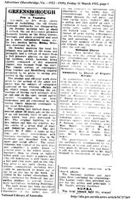
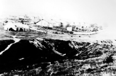
Newspaper Clipping, Greensborough. Fire in township, 11/03/1932
This article reports on the fire that destroyed the original timber Greensborough Hotel. The original hotel was built in 1860 at the corner of Grimshaw and Church Streets by Frederick Ellis. According to this article the original building was replaced in the late 1890s.2 page newspaper clipping. Downloaded from Trove.greensborough hotel, grimshaw street greensborough, church street greensborough -
 Greensborough Historical Society
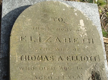
Photograph - Digital Image, Grave of Thomas A Elliott and Elizabeth Elliott, Greensborough Cemetery, 01/12/1880
Grave of Thomas A Elliott (died 01/12/1880) and Elizabeth Elliott (died 16/08/1868) in Plot# C3 and C4 Greensborough Cemetery. The Elliott family arrived in Greensborough in the early 1860's.Greensborough Cemetery was created when land was given for the cemetery by Mr William Poulter, a local settler, about 1864. The cemetery holds the graves of many early settlers in the district. Digital copy of colour photograph of grave/headstone.thomas a elliott, elizabeth elliott, greensborough cemetery -
 Greensborough Historical Society
Photograph - Digital Image, Grave of Thomas A Elliott and Elizabeth Elliott, Greensborough Cemetery, 01/12/1880
Grave of Thomas A Elliott (died 01/12/1880) and Elizabeth Elliott (died 16/08/1868) in Plot# C3 and C4 Greensborough Cemetery. The Elliott family arrived in Greensborough in the early 1860's.Greensborough Cemetery was created when land was given for the cemetery by Mr William Poulter, a local settler, about 1864. The cemetery holds the graves of many early settlers in the district. Digital copy of colour photograph of grave/headstone.thomas a elliott, elizabeth elliott, greensborough cemetery -
 Uniting Church Archives - Synod of Victoria
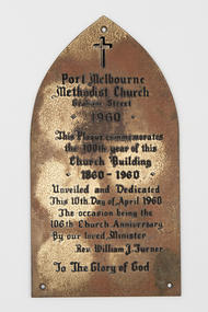
Plaque
Arch-shaped brass plaque etched black calligraphy for church centenary."Port Melbourne Methodist Church Graham St. 1960. This Plaque commemorates the 100th year of this Church Building 1860 - 1960. Unveiled and Dedicated This 10th Day of April 1960 The occasion being the 106th Church Anniversary By our loved Minister Rev William J Turner. To The Glory of God"port melbourne methodist church graham street -
![Map, Public Lands Office, Township of Sandridge [cartographic material] / lithographed at the Public Lands Office, March 30th 1859, 30 March 1859](/media/collectors/4f729f5897f83e0308601603/items/63c6354eae7bf372478c58b7/item-media/63c635d4ae7bf372478c7627/item-fit-380x285.jpg) Mission to Seafarers Victoria
Mission to Seafarers VictoriaMap, Public Lands Office, Township of Sandridge [cartographic material] / lithographed at the Public Lands Office, March 30th 1859, 30 March 1859
The map shows where the land of the Customs House was and where the Bethel church was built in 1860. It also shows the name Gregory, a family of land owners who became the managers of the new building on the same site in 1889.sandridge, bethel church, customs house, gregory -
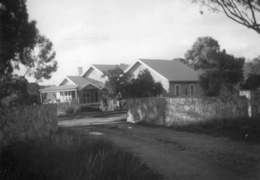
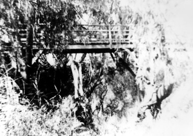
![Photograph - Digital image, Pioneer Children's Graves [graves and aqueduct], 1985_](/media/collectors/4f729f5697f83e03086015b8/items/54bb57442162f10ca8d7a0b6/item-media/54bb57762162f10ca8d7a408/item-fit-380x285.jpg) Greensborough Historical Society
Greensborough Historical SocietyPhotograph - Digital image, Pioneer Children's Graves [graves and aqueduct], 1985_
The unmarked graves of the children of two Greensborough pioneer families lie in a private cemetery on the Plenty River. Burials occurred between 1848 and 1860. This photograph shows the cemetery site with jonquils in bloom and the Maroondah Aqueduct in the background. An important historical site in Greensborough.Digital copy of colour photograph.pioneer childrens cemetery, maroondah aqueduct, whatmough, partington -
 Greensborough Historical Society
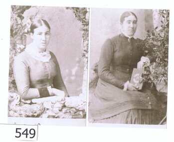
Photograph - Photograph (copy), Prudence Partington and Maria Partington, 1883c
The ladies are from the Partington family. Prudence Partington b 1858, d March 1930. Maria Partington b 1860, d January 1930. Both were unmarried. Both buried at Jessop Street Cemetery.The Partingtons were a pioneering family in the Greensborough district.An A4 black and white copy of 2 Partington sisters.The sisters' names are written in biro on the rear of the card. partington, greensborough cemetery, maria partington, prudence partington -
 Stawell Historical Society Inc
Photograph, “Overdale” Homestead in Concongella
“Overdale” Holden Homestead Concongella. James Holden settled on "Overdale" in the late 1860's. The Holden Family still live at "Overdale" The Holden Family have served on the Stawell Shire Council for over 100 years.Black and White enlarged photograph of house in file and small original photo in album. Building has prominent stone wall and trees around the house which has an inner timber and wire fence. Overdale sign on the stone wall.stawell -
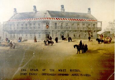 Port Fairy Historical Society Museum and Archives
Photograph
Built in 1856 The Star of the West was to be the first of many "Stars" throughout Victoria but John Walwyn Taylor died in 1860 at the age of 40 years having built only one. Cobb and Co had a livery stables Photograph with added features such as a red and white striped verandah The Star of the West Hotelhotel, port fairy, bank street, sackville street, star of the west, john walwyn taylor, cobb and co -
 Friends of Ballarat Botanical Gardens History Group
Photograph - First residence of George Longley and family in the Ballarat Botanical Gardens, North Lodge, George Longley residence, 1863-1867, 1st Curator of the Ballarat Botanical Gardens, C 1863-1867
First curator's cottage, was built in the gardens early 1860's, later moved to 1414 Gregory St, now relocated back to the Northern Gardens and used by the "Friends of the Ballarat Botanical Gardens" for meetings and Botanikids activities.The Cottage is important as an early structure in the Ballarat Botanical Gardens. It is one of the early works of the Ballarat pioneer architect, Cassini. Its removal from Gregory Street back to the Gardens is testament to the generosity and enthusiasm of the Friends of the Ballarat Botanical Gardens. Its renovation was funded by the Ballarat City Council and the Friends of the Botanic Gardens as an important landmark from the past. It is now visited, used and enjoyed by the community. Many original features of the Cottage are intact with a modern extension.Blurred photograph in parts especially lower half of the photograph.Back of black and white photograph in biro, longhand print, "North Lodge - Geo.Longley First Curator- Residence. From 1863 to 1867 Gardens Cottage Built." Now located at 1414 Gregory Street. In faint print, THORNTON RICHARDjohn garner collection, garner, dr, george longley, longley, curator, curator house, ballarat botanical gardens, ballarat, gardens, north lodge, cassini, architect, northern gardens, longley family -
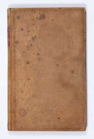 Bacchus Marsh & District Historical Society
Administrative record, Bacchus Marsh Prince of Wales Light Horse records March 1867- March 1877. Book 2
A military unit of the Victorian Volunteer Colonial military forces was formed in Bacchus Marsh in 1860. The unit was commonly called the Bacchus Marsh Troop but was more formally known as the Bacchus Marsh Prince of Wales Light Horse.Foolscap size ledger book. Bound. Gold colored covers with rectangular red section on spine which has gold lettering inside it. The book is mainly a record of stores received by the Bacchus Marsh Light Horse Troop. Stores or supplies noted include shot and shell, saddle cloths, shoulder belts, bugles, leather, ammunition, uniforms and clothing details such as great coats and tunics and firearms such as rifles. Some pages contain details of specific firearms received such as Lancaster and Martini Henry rifles. Most entries relate to supplies received. Some pages contain specific supplies provided to each member of the troop who are individually listed by name and rank alongside their allotted supplies.'Stores Received' on spinearmed forces, bacchus marsh volunteer military troop, colonial military forces -
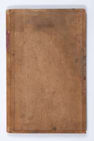 Bacchus Marsh & District Historical Society
Administrative record, Bacchus Marsh Prince of Wales Light Horse records January 1867 - July 1876. Book 1
A military unit of the Victorian Volunteer Colonial military forces was formed in Bacchus Marsh in 1860. The unit was commonly called the Bacchus Marsh Troop but was more formally known as the Bacchus Marsh Prince of Wales Light Horse.Foolscap size ledger book. Bound. Gold colored covers with rectangular red section on spine which has gold lettering inside it. The book is mainly a record of stores received by the Bacchus Marsh Light Horse Troop. Stores or supplies noted include shot and shell, saddle cloths, shoulder belts, bugles, leather, ammunition, uniforms and clothing details such as great coats and tunics and firearms such as rifles. Some pages contain details of specific firearms received such as Lancaster and Martini Henry rifles. Most entries relate to supplies received. Some pages contain specific supplies provided to each member of the troop who are individually listed by name and rank alongside their allotted supplies.'Stores Received' on spinearmed forces, bacchus marsh volunteer military troop, colonial military forces -
 Bacchus Marsh & District Historical Society
Administrative record, Bacchus Marsh Prince of Wales Light Horse records 1872-1877
A military unit of the Victorian Volunteer Colonial military forces was formed in Bacchus Marsh in 1860. The unit was commonly called the Bacchus Marsh Troop but was more formally known as the Bacchus Marsh Prince of Wales Light Horse.Foolscap size ledger book. Bound.armed forces, bacchus marsh volunteer military troop, colonial military forces -
 Bendigo Historical Society Inc.
Book - STRAUCH COLLECTION: MEMOIRES OF A BENDIGO PIONEER- BOLDT DIARY
Albert Wilhelm August Boldt (1829-25/8/1895) was born in Strasbourg, Prussia. HE came to Australia and Bendigo in 1854 where he undertook mining. In 1860 he married Elise Marie Streiff.The following pages contain what is evidently the diary of Albert Wilhelm August Boldt, but it is not known who made the introductory comments and was very likely also the person who translated it into the English language. The original is in the hands of Richard Slade of 9 Phillips avenue Carnegie Vic 3163 and several copies were made with his permission in mid 1992.person, individual, albert wilhelm august boldt -
 The Beechworth Burke Museum
Photograph - Photograph - Reproduction
This photograph depicts the Great Southern Mine located in Rutherglen as it was during the 1900. After the initial Gold Rush of 1853-1854, Gold was discovered deeper under the surface of the earth in the 1860 after the discovery of another deep lead system. Due to the discovery of Gold in Rutherglen, Rutherglen developed into a community in its own right, possessing a population of 6600 by December 1860 and developed into a municipality in 1862. The Great Southern Mine depicted in this photograph required the use of a range of modern technologies, including the hydraulic pumps, in order to reach gold. This photo depicts the mining operations as they were undertaken around the turn of the century.The search for gold is ingrained into the history of Victoria and therefore, images like this one which portray a modern mining operation undertaken in the 1860s, can reveal important information for society and technology for the date when the photograph was taken. This image is of important historical significance for its ability to convey information about the methods used to extract gold in 1900. It is significant as most mining operations around the region, particularly earlier on in the period, used different technologies such as water races. This image is important for current research into the history of Rutherglen more generally, a town which developed singlehandedly due to the discovery of minerals and mining, as depicted here in this photograph, thus indicating an element of social significance as well as historic. The Beechworth Burke Museum has additional images relating to mining and Rutherglen which can be analysed and studied alongside images like this one.A black and white rectangular photograph printed on matte photographic paper.Reverse: $ 3.00 19972503 / a02503 / Great Southern Mine Rutherglen 1900rutherglen mine, rutherglen, great southern mine, beechworth, mine, mining, post goldrush, victoria, gold, 1860s, sluicing, hydrolic sluicing -
 Warrnambool and District Historical Society Inc.
Bell, James Barwell, Animal, C 19th century
Bells of this type were normally used to hang around the necks of cows, horses or bullocks to prevent them from being lost and were used from around the 1860's onwards. The initial J B identify the bell as being made by James Barwell who made bells for the Australian market from around the 1860's. His bell and brass foundry manufactured all sorts of bells from school bells to full church peals as well as plumbing fittings. The four marks on the edge of the bell are typical of those used by drovers or owners to identify their animal. While this bell has no known local provenance, it is a link to the early cattle and agricultural life in Australia and most likely the Western District. Its significance lies in the fact that it is typical of bells used for a purpose at that time and as such can be used for discussion in a social and interpretive context.This is a brass bell of the type used to hang around the necks of animals such as cows, horses and bullocks. The mechanism for the attachment to a collar or harness has been sheared off and the clapper is detached from the inside hook. The bell has an inscription incised around the top and there are four small cuts or incisions made into the bell at the wider end. The bell is a little tarnished.‘Success to 4 in horse teams J.B.’history of warrnambool, animal husbandry, animal bell, james barwell bells -
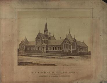 Federation University Historical Collection
Photograph - Sepia, Bardwell and Beauchamp, State School No 2103, Ballarat, c1878
Urquhart Street Primary School was opened on 09 December 1878 by the Minister of Public Instruction, Major William Collard Smith. The school originated from Errard School no 227 which was extablished by the Presbyterian Church as early as 1860.Brick School building with bell tower known as Urquhart Street Primary School. Llewellyn and Edwards were the contractors. The photograph shows a brick building on a corner behind a picket fence. ballarat, school, education, llewellyn and edwards, urquhart street primary school -
 Clunes Museum
Document - DOCUMENTS
Mr. Hugh Neill was one of the first engineers of the Mount Morgan Gold Mining Co. Ltd, he came to Australia from London in the 1860's and was engaged as chief engineer of the Port Phillip Gold Mining Co.1. PHOTO COPY OBITUARY NOTICE MR. N.G. NEILL 2. INTERNMENT NOTICE IN CLUNES CEMETERY OF SIX WEEKS OF AGE OF SARAH NEILL 3. CERTIFICATE HUGH NEILL ISSUED BY LODGE OF ALL NATIONS NO. 425 CLUNES. 4. CERTIFICATE OF RIGHT OF BURIAL IN CLUNES CEMETERY OF HUGH NEILLlocal history, newspaper cutting, receipt, certificate -
 Port Melbourne Historical & Preservation Society
Photograph - Civic structures, Port Melbourne, Ron LAING, Ron Laing, 1986 - 1999
Part of Ron Laing's collection of photographs recording Port Melbourne over a thirteen year period. Donated to the PMH&PS by the photographer.A set of 37 colour photographs of Port Melbourne civic stuctures, 1990s, including the Town Hall, Liardet Community Centre, Freemasons' Hall, RSL Club (Excelsior Hall), old fire station, 1910 Post Office, 1860 Post Office and Naval Drill Hall, Metropolitan Fire Station, Police quarters, Police Station and Court House, Nott Street State School, Graham Street State School, St Joseph's Primary School and Rotunda in Beach Streetbuilt environment - civic, ron laing, nott street state school, graham street state school, port melbourne primary school, port melbourne town hall, liardet community centre, excelsior hall, freemasons hall, fire station, post office, naval drill hall, police station, st josephs catholic primary school, band rotunda -
 Bendigo Historical Society Inc.
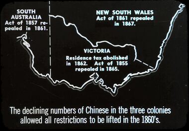
Slide - DIGGERS & MINING. THE CHINESE ON THE GOLD FIELDS, c1850s
Diggers & Mining. The Chinese on the Gold Fields. Slide: Shows map of Victoria and part of South Australia and New South Wales. South Australia Act. Of 1857 repealed I 1861. New South Wales Act. Of 1861 repealed I 1867. Victoria Residence tax abolished in 1862. Act. Of 1855 repealed in 1865. The declining numbers of Chinese in the three colonies allowed all restrictions to be lifted in the 1860's. Markings: 2 2. Used as a teaching aid.hanimounteducation, tertiary, goldfields -
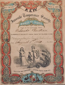 Kew Historical Society Inc
Certificate - Juvenile Temperance Society: Band of Hope, Juvenile Temperance Society, 1860
An item from an outstanding and diverse photographic collection, assembled by members of the Christian and Washfold families of Kew.Juvenile Temperance Society Kew ‘Band of Hope’ issued to Orlando Christian on 1 August 1860. The two- colour printed certificate advises the member to avoid the use of tobacco and snuff and commits the child to abstain from intoxicating drinks. The illuminated certificate has a prototype Australian coat of arms centred in the lower border. The Band of Hope movement originated in Leeds in 1847. In contrast to the Rechabites it was a children’s movement. The Band of Hope movement had Australian ‘chapters’ from the 1850s (sic).orlando henry beater christian, christian-washfold collection, juvenile temperance society -- victoria -- australia -
 Bendigo Historical Society Inc.
Slide - DIGGERS & MINING. LIFE OF THE SELECTORS, c1880
BHS CollectionDiggers & mining. Life Of The Selectors. 2 men, 4 cattle, 2 horses, timber hut with out building, and a cart sitting nearby. There has been a timber fence constructed behind the buildings. One man is using the cattle to pull timber, the other is using an axe to chop a large tree down. Markings; Life Of The Selectors 1860-1890 Set 432 No.9. Selectors Clearing the Forest - ''The Australasian Sketcher,'' Jan. 31, 1880. Used as a teaching aid.Visual Education Centreeducation, tertiary, goldfields -
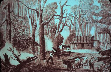
 Bendigo Historical Society Inc.
Slide - DIGGERS & MINING. LIFE OF THE SELECTORS, c1876
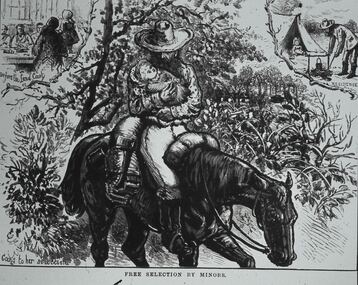
BHS CollectionDiggers & mining. Life Of The Selectors. Minor carring baby while riding horse, people at table on the left at top rear. Minor boiling the billy, and a small child in the tent at the rear right of picture. Markings; Life Of The Selectors 1860-1890. Set 432 No.2 Free. Selection by Minors - ‘’The Australian Sketcher,' Jan 22, 1876. Caption at bottom of sketch; Free By The Minors. Rear left caption; Before the Land Court. Caption rear right; A residence. Used as a teaching aid.Visual Education Centreeducation, tertiary, goldfields -
 Bendigo Historical Society Inc.
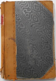
Document - LANDS OFFICE - CROWN LANDS SURVEYED AND SOLD SANDHURST, 1860 onwards
Journal: LANDS OFFICE - CROWN LANDS SURVEYED AND SOLD SANDHURST green hard cover journal with buff spine and corners. Contains details of crown land surveyed and sold in the district of Sandhurst. Indexed in front by parish, alphabetical double pages not numbered. On LH page, parish, town, suburban, country, date of survey. On RH page, date of sale, auction, selection, price, total amount, purchaser. On spine ' index book' 'F' and '09'. Dated from 1860 onwardsLands Officeland sales, bendigo -
 Surrey Hills Historical Society Collection
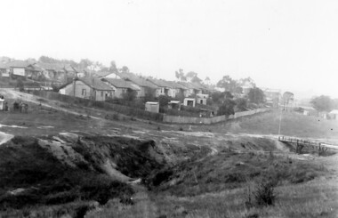
Photograph, Back Creek (later South Surrey Park), c 1936, 1936
This photo was taken at the opening of the footbridge by Sir Winston Dugan in 1936.South Surrey Park was developed on land which had been the property of the Kleinert family. Their land extended from Union Road to Essex Road. They ran horses, ducks and fowls and Emily Kleinert grew flowers. Alan Holt research: Lot 6 was sold to Martin Klienert by Karl Richter in 1860 together with a portion of another adjacent lot. From 1860-1885 Martin worked it as a market garden leasing some land for grazing when it was not required for gardening. He died in 1898. In a formal document, William declared he was the son of Martin "who purchased land in 1860, died in 1898 and the land has been continually occupied by father and family since. It has been cultivated as a market garden; when not being used for gardening it was let for cultivation and grazing." William died in 1939 and the property passed to his sons Martin and Ernest. The family sold the land to the Camberwell Council in the 1950s.This photo is significant as it shows the transition from rural to urban land use in Surrey Hills.Black and white photo taken in the area later known as South Surrey Park. Back Creek is in the foreground. There is a tent on the LHS and approximately 7 houses which front Verdun Street. Some of their backyards face onto the open space along the creek bed.parks and reserves, creeks, south surrey park, civic occasion, official events, back creek, verdun street, 1936, kleinert family, sir winston dugan, topography -
 Surrey Hills Historical Society Collection
Photograph, Footbridge across Back Creek, 1980, 1980
South Surrey Park was developed on land which had been the property of the Kleinert family. Their land extended from Union Road to Essex Road. They ran horses, ducks and fowls and Emily Kleinert grew flowers. Alan Holt research: Lot 6 was sold to Martin Klienert by Karl Richter in 1860 together with a portion of another adjacent lot. From 1860-1885 Martin worked it as a market garden leasing some land for grazing when it was not required for gardening. He died in 1898. In a formal document, William declared he was the son of Martin "who purchased land in 1860, died in 1898 and the land has been continually occupied by father and family since. It has been cultivated as a market garden; when not being used for gardening it was let for cultivation and grazing." William died in 1939 and the property passed to his sons Martin and Ernest. The family sold the land to the Camberwell Council in the 1950s. The original footbridge was opened by Sir Winston Dugan in 1936.Black and white photo of a wooden footbridge with large trees and shrubs obscuring its surrounds.parks and reserves, creeks, south surrey park, back creek, verdun street, footbridges -
 Uniting Church Archives - Synod of Victoria
Photograph, 3.3.1991
Jubilee Primitive Methodist Church. A brick church of 1860 designed by Crouch and Wilson and an unusually early use of the Gothic style by the Primitive Methodists. The most distinctive element of the design is the pair of flying buttresses projecting at angles from the facade.B & W photograph of the exterior of the Chewton Primitive Methodist Church.ex Primitive Methodistchewton, jubileel primitive methodist, crouch and wilson, gothic -
 Kew Historical Society Inc
Photograph - Aerial View of East Kew, c.1930
The Municipality of Kew was proclaimed in 1860. This eastern section of Kew was settled from the 1850s with all land sold in the vicinity by 1851. The original large estates were further subdivided in the second half of the 19th and in the first decades of the 20th centuries.Early aerial photograph of KewFramed aerial photograph of that part of Kew in which is located Genazzano FCJ, the Kew Reservoir, and the retail nurseries of Bennett’s and Rimington's.genazzano fcj, kew reservoir, rimington's nurseries, bennett's nursery, cotham road, mont victor road (kew) -
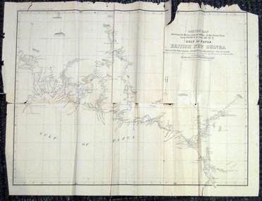 Federation University Historical Collection
Map, British New Guinea, 1893, 1893
The map was surveyed by ship compass, distances by estimation or rate of launch by officers of the Government ; supervised and compiled by J.B. Cameron, G.S. March 1893. This map was in the possession of Charles Carty Salmon (1860-1917), politician, born on 27 July 1860 at Amherst, Victoria. (http://adb.anu.edu.au/biography/salmon-charles-carty-8328 ) Although living in Melbourne Charles Carty Salmon kept property at Talbot. The property was leased, then purchased by the donor's family. A copy of "The Goulburn Weir and its Dependent System of Works" and this map (in a government envelope addressed to Salmon) were left at the property. See http://nla.gov.au/nla.map-rm1894-1 .1) Sketch map showing the rivers and an outline of the coast from Long. 144?30'E. to Long. 146?30'E. Gulf of Papua British New Guinea Scale [ca. 1:316,800]. .2) Large envelope addressed to The Hon Charles Carty Salmon M.P., Talbot, Victoria. The map was folded and stored in this envelope. Map extending from Port Bevan to Kaikavau Pt, showing rivers and notes on soil and vegetation. Relief shown by hachures and spot heights. Also available in an electronic version via the Internet at: http://nla.gov.au/nla.map-rm1894-1 .1) "Enclosure in Despatch No. 32 of 3rd May 1893 - Appendix G.". "Map no. 4 British New Guinea report 1892-93". .2) "This envelope can only be lawfully used by Government Officials on public business. Any use by Officials on private business, or by others under any circumstances, is punishable." "Commonwealth Celebrations. General Secretary's Office, Melbourne."carty salmon, charles carty salmon, new guinea, j.b. cameron