Showing 4449 items
matching roads board
-
![Flooding at Chipperfield's Boathouse [East Kew], 1934](/media/collectors/550653872162f11fb04854aa/items/58cbaad5d0cec425b474bfb1/item-media/58cf6fbdd0cf9f331490feb0/item-fit-380x285.jpg) Kew Historical Society Inc
Kew Historical Society IncPhotograph, Flooding at Chipperfield's Boathouse, 1934
... was in the 1850s administered by the Borondara Road Board... administered by the Borondara Road Board. This was compounded ...Living with natural processes was frequently a challenge to early European settlers and later residents of what was in the 1850s administered by the Borondara Road Board. This was compounded by the area being bounded on three sides by rivers (Yarra River, Koonung Creek and Gardiner's Creek). In 1849, the historian James Bonwick recorded that "our district [Kew] suffered considerably. Mr Wade speaks of 80 acres, out of 100 acres of his cultivated paddock, covered by water." Newspapers continued to describe major flooding in Kew in 1863, 1869, 1878, 1880, 1889, 1891, 1916 and 1934. While the construction of the Upper Yarra dam in 1957 reduced the levels of flowing downstream, local and riverine floods continue.The Kew Historical Society's pictures and map collections testify to the impact of flooding in the district. They have historical importance in documenting the extent of flooding in the district and its affects on homes, services and recreation. Numerous photographs record flooding throughout the Twentieth Century.Floods in North Kew, 1934. Chipperfield's Boathouse and the adding Moorings was located beside the Yarra River near the corner of Willsmere and Kilby Roads. The flood reached the roof of the Moorings, which can be seen in the photo.floods (kew), floods (kew) 1934, yarra river -
 Kew Historical Society Inc
Photograph, Floods in North Kew, 1934
... was in the 1850s administered by the Borondara Road Board... administered by the Borondara Road Board. This was compounded ...Living with natural processes was frequently a challenge to early European settlers and later residents of what was in the 1850s administered by the Borondara Road Board. This was compounded by the area being bounded on three sides by rivers (Yarra River, Koonung Creek and Gardiner's Creek). In 1849, the historian James Bonwick recorded that "our district [Kew] suffered considerably. Mr Wade speaks of 80 acres, out of 100 acres of his cultivated paddock, covered by water." Newspapers continued to describe major flooding in Kew in 1863, 1869, 1878, 1880, 1889, 1891, 1916 and 1934. While the construction of the Upper Yarra dam in 1957 reduced the levels of flowing downstream, local and riverine floods continue.The Kew Historical Society's pictures and map collections testify to the impact of flooding in the district. They have historical importance in documenting the extent of flooding in the district and its affects on homes, services and recreation. Numerous photographs record flooding throughout the Twentieth Century.Floods in North Kew, 1934. Unidentified location on the Yarra Flood Plain at Kew.floods (kew) 1934, yarra river -
 Kew Historical Society Inc
Photograph, Floods in North Kew, 1934
... was in the 1850s administered by the Borondara Road Board... administered by the Borondara Road Board. This was compounded ...Living with natural processes was frequently a challenge to early European settlers and later residents of what was in the 1850s administered by the Borondara Road Board. This was compounded by the area being bounded on three sides by rivers (Yarra River, Koonung Creek and Gardiner's Creek). In 1849, the historian James Bonwick recorded that "our district [Kew] suffered considerably. Mr Wade speaks of 80 acres, out of 100 acres of his cultivated paddock, covered by water." Newspapers continued to describe major flooding in Kew in 1863, 1869, 1878, 1880, 1889, 1891, 1916 and 1934. While the construction of the Upper Yarra dam in 1957 reduced the levels of flowing downstream, local and riverine floods continue.The Kew Historical Society's pictures and map collections testify to the impact of flooding in the district. They have historical importance in documenting the extent of flooding in the district and its affects on homes, services and recreation. Numerous photographs record flooding throughout the Twentieth Century.Floods in North Kew, 1934. Chipperfield's Boat House under flood.floods (kew) 1934, yarra river, chipperfield's boat house -
 Kew Historical Society Inc
Photograph, Floods in North Kew, 1934
... was in the 1850s administered by the Borondara Road Board... administered by the Borondara Road Board. This was compounded ...Living with natural processes was frequently a challenge to early European settlers and later residents of what was in the 1850s administered by the Borondara Road Board. This was compounded by the area being bounded on three sides by rivers (Yarra River, Koonung Creek and Gardiner's Creek). In 1849, the historian James Bonwick recorded that "our district [Kew] suffered considerably. Mr Wade speaks of 80 acres, out of 100 acres of his cultivated paddock, covered by water." Newspapers continued to describe major flooding in Kew in 1863, 1869, 1878, 1880, 1889, 1891, 1916 and 1934. While the construction of the Upper Yarra dam in 1957 reduced the levels of flowing downstream, local and riverine floods continue.The Kew Historical Society's pictures and map collections testify to the impact of flooding in the district. They have historical importance in documenting the extent of flooding in the district and its affects on homes, services and recreation. Numerous photographs record flooding throughout the Twentieth Century.Floods in North Kew, 1934. Flood near the lagoon (Billabong?)floods (kew) 1934, yarra river -
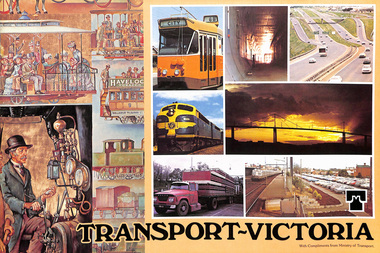
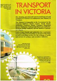 Melbourne Tram Museum
Poster, Minister of Transport, Transport in Victoria", late 1970's
... to the Ministry of Transport. , Country Roads Board, Victorian Railways... of Transport. , Country Roads Board, Victorian Railways Board ...Full colour poster, single sided, printed on gloss white paper, titled Transport in Victoria", giving details of the functions and the various authorities and boards reporting to the Ministry of Transport. , Country Roads Board, Victorian Railways Board, Westgate Bridge Authority, Melbourne Tramways Board, Melbourne Underground Rail Loop Authority, Transport Regulation Board, Railway Construction Board Has photos of the various activities of the Boards, including an aerial photo of Melbourne CBD from the south east, showing the Flinders St rail yards. Photo of Z class tram, but number has been removed. Has the Ministry logo in the bottom right hand corner. See also Reg Item 1352 for a book of the same title.In ink in top left hand corner "4J40" - AETA Library location.trams, tramways, minister for transport, railways, trb, crb, murla -
 Eltham District Historical Society Inc
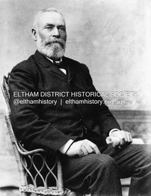
Photograph, C.S. Wingrove, Secretary, Eltham District Road Board 1858-1871; Shire Secretary, Shire of Eltham 1871-1904, 1858-1871
... C.S. Wingrove, Secretary, Eltham District Road Board 1858...eltham district road board... District Roads Board only one year after its foundation. He... District Roads Board only one year after its foundation. He ...Charles Symons Wingrove, J.P. (1829-1905) arrived in Victorian in 1851. He had trained as an engineer, but tried his luck on the goldfields. In 1857 he was appointed as Secretary to the Eltham District Roads Board only one year after its foundation. He was to hold the position with the Board and later the Eltham Shire Council for total of 47 years. He also held the position of engineer for a large part of this period. During part of this time he was also secretary to the Heidelberg Shire Council. Over this period he was responsibly for an area stretching from Clifton Hill to Healesville, along the northern bank of the Yarra River. Other positions included Secretary to the Victorian Agricultural Society over along period.Wingrove was a main figure in the Municipal Association of Victoria. By the time he retired he was recognized as the “Grand Old Man” of Victorian local government. In 1858 Wingrove had a brick cottage built in Main Road near the State School and he lived here until his death. One room was uded as the Board and Council office. His descendants owned the house until 1974. It was later used as a psychiatric clinic. The park opposite the cottage has been named Wingrove Park in his honour. He is buried at St Helena with other members of his family. Age (Melbourne, Vic. : 1854 - 1954), Tuesday 18 July 1905, page 5 ABOUT PEOPLE. A conspicuous figure in northern municpal history, Mr. Charles Symons Wingrove, has passed away. He was for many years secretary and engineer for the shire of Eltham, and prior to the formation of the shire held the position under the old road board, his official connection with the district dating from beyond 1857. For about twelve years he also filled the position of shire engineer for Heidelberg council while retaining his other post, and the immense territory under his professional control, reaching from the boundary of Collingwood up to Healesville, was a matter of fatherly pride and interest to him. He arrived in Victoria in 1851, and was 76 years of age at his death. Mr. Wingrove retired from the position in the Eltham council only about a year ago. The interment will take place in St. Helena Cemetery, near Eltham township, today. Secretary, Eltham District Road Board 1858-1871 Secretary for the Shire of Eltham 1871-1904. Nearly 50 years service to the local community. For about twelve years he also filled the position of shire engineer for Heidelberg council. Reproduced Page 137 "Pioneers & Painters" This photo forms part of a collection of photographs gathered by the Shire of Eltham for their centenary project book,"Pioneers and Painters: 100 years of the Shire of Eltham" by Alan Marshall (1971). The collection of over 500 images is held in partnership between Eltham District Historical Society and Yarra Plenty Regional Library (Eltham Library) and is now formally known as the 'The Shire of Eltham Pioneers Photograph Collection.' It is significant in being the first community sourced collection representing the places and people of the Shire's first one hundred years.Digital image Print 25 x 20 cmc.s.wingrove, charles symons wingrove, eltham district road board, sepp, shire of eltham pioneers photograph collection, shire secretary, wingrove cottage, pioneers and painters, shire of eltham, councilor, municipal officer -
 Orbost & District Historical Society
memorial document, 18th July, 1922
... bringing the railway to Orbost and establishing the Country Roads... the Country Roads Board. James Cameron was an early Orbost pioneer ...This is an extract from the Victorian Parliamentary Debates on Tuesday 18th July, 1922. It is titled "Death of the Honorable James Cameron" and is a tribute from Mr Lawson, the Victorian premier. In 1882 James Cameron was the first Orbost councillor of the newly constituted Tambo Shire. In the next twenty years he served as justice of the peace, shire councillor, guardian of St James's Anglican Church, Sunday school superintendent and president of the local agricultural society. In 1902 he won a by-election for Gippsland East and took his seat in the Legislative assembly. He serve for eighteen years and his main achievements were securing one million pounds for East Gippsland development bringing the railway to Orbost and establishing the Country Roads Board.James Cameron was an early Orbost pioneer, a respected community member and a prominent politician.A memorial extract from the Victorian Parliamentary Debates. It is on white paper with black print, a black border and is tied with black ribbon.cameron-james-orbost -
 Eltham District Historical Society Inc
Folder, Pioneers & Painters; Manuscript, 1971, 1971-1978
... Eltham District Road Board Members 04769-3 Shire of Eltham... Eltham District Road Board Members 04769-3 Shire of Eltham ...Material pertaining to the production of a history of the Shire of Eltham, "Pioneers & Painters: One Hundred Years of Eltham and its Shire" in recognition of the shire's centenary in 1971 Item Title 04769-1 Manuscript: Pioneers & Painters - A History of Eltham Shire, edited by Alan Marshall, 1971 04769-2 Eltham District Road Board Members 04769-3 Shire of Eltham Councillors 04769-4 Galley Proof, Pioneers & Painters, Appendices pp137-138 04769-5 Eltham Shire Celebrates 100 Years of Colour and Progress; Book Review, The Australian Municipal Journal, July 1971, p 13 04769-6 Letter: Acknowledgement from RHSV to Shire of Eltham Historical Society that Pioneers & Painters is to be reprinted, 10 November 1978 The idea to develop a book on the history of the Shire of Eltham to be edited by noted author, Alan Marshall in celebration of the shire's centenary was initiated in 1969. The Shire of Eltham Historical Society undertook significant research in conjunction with Alan Marshall locating material at various institutions and other societies; interviewing longer term residents and a public campaign through the local press to acquire photographic material for duplication and use in the book. The public campaign received generous response and the material collected became the genesis for the Shire of Eltham Pioneers Photograph collection now held in partnership between Eltham District Historical Society and Yarra Plenty Regional Library (Eltham Library).Paper documents of various sizesalan marshall, cr. charis pelling, manuscript, pioneers and painters, rhsv, royal historical society of victoria -
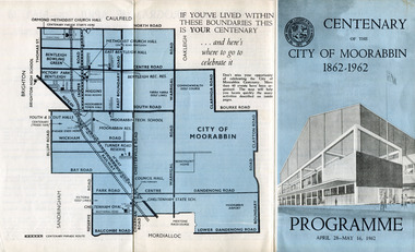 City of Moorabbin Historical Society (Operating the Box Cottage Museum)
Pamphlet - Centenary of the City of Moorabbin 1862 - 1962, Programme April28 - May16, 1962, 1962
... Sandringham, Mentone and Mordialloc was made a Road Board District..., Mentone and Mordialloc was made a Road Board District, on 27 ...In 1962 the City of Moorabbin celebrated one hundred years of self local-government. The celebrations commemorated those who helped form the City of Moorabbin and to recognise their achievements. In May 1862 the Moorabbin district, which included Sandringham, Mentone and Mordialloc was made a Road Board District, on 27 January 1871 it was made a shire and then on 29 November 1934 Moorabbin was proclaimed a City. On 15 December 1994, the City of Moorabbin was abolished, and was split three ways; Bentleigh was transferred into the newly created City of Glen Eira along with the City of Caulfield; Cheltenham was transferred to the newly created City of Bayside, along with the Cities of Brighton and Sandringham; while the bulk of the city merged with the Cities of Mordialloc, Chelsea and parts of Springvale, to become the newly created City of Kingston.A souvenir of the celebration of 100 years of self government by theearly settlers from Moorabbin Roads Board 1862 until City of Moorabbin 1934-62 A tri-fold pamphlet colour print on outside and black and white inside. List of Councillors of City of Moorabbin 1961-1962 - Programme of all the events held to celebrate the Centenary of the City of Moorabbin from April 28 - May 16, 1962Centenary /of the / City of Moorabbin / 1862 -1962city of moorabbin, centenary, celebrations, floats, parade -
 Eltham District Historical Society Inc
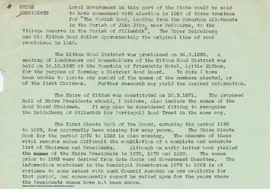
Document - Appendix, M.B. Watson, Shire Secretary, List of Former Road Board Chairmen and Shire Presidents (1856-1966), 28 Nov 1966
... List of Former Road Board Chairmen and Shire Presidents..., for the purpose of forming a District Road Board. To date I have been..., for the purpose of forming a District Road Board. To date I have been ...Appendix to Shire Secretary’s Report, 28 November 1966 SHIRE PRESIDENTS Local Government in this part of the State could be said to have commenced with election in 1846 of three trustees for "The Parish Road, leading from the Suburban Allotments in the Parish of Jika Jika, near Melbourne, to the Village Reserve in the Parish of Nillumbik". The Upper Heidelberg and Old Eltham Road follow approximately the original line of road proclaimed in 1840. The Eltham Road District was proclaimed on 24.9.1856. A meeting of landowners and householders of the Eltham Road District was held on 14.10.1856 at the Fountain of Friendship Hotel, Little Eltham, for the purpose of forming a District Road Board. To date I have been unable to locate any record of the names of the members elected, or of the first Chairman. Further research may yield the desired information. The Shire of Eltham was constituted on 28.3.1871. The proposed Roll of Shire Presidents should, I believe, also include the Road Board Chairmen. It may also be considered fitting to recognise the Heidelberg or Nillumbik (or Warringal) Road Trust in the same way. The first Minute Book of the Board, covering the period 1856 to 1863, has apparently been missing for many years. The Shire Minute Book for the period 1878 to 1885 is also missing. The absence of these vital records makes difficult the compilation of a complete and accurate list of Chairmen and Presidents. Although an early letter book yielded the names of the Shire Presidents in 1878, 1879 and 1800. The names prior to 1863 were derived from Rate Books and Government Gazettes. The information contained in the Municipal Directories 1875 to 1885 is at variance to some extent with such Council records as are available for that period, and consequently cannot be relied upon for the years where the Presidents names have not been shown. shire of eltham archives, series listing, a. armstrong, a. beale, a. brinkkotter, a. donaldson, a.h. price, a.j. braid, c.h. bath, c.m.a. pelling (mrs.), c.t. bell, d.c. o'beirne, e.d. butler, e.h. cameron, e.j. andrew, e.p. harmer, f.e. griffith, f.v. squire, f.w. nankervis, g. love, g. robertson, h. dendy, h. hewitt, h. stooke, l.t. wilmot, j. cox, j. murray, j. barr, j. bell, j. fitch, j. herbert, j. lawrey, j. mealy, j. pape, j. ryan, j. smedley, j.b. shallard, j.l. beale, l. c. docksey, r. mcadam, r.a. bell, r.c. white, r.r. woolcott, rutter, s.s. addison, s.w. scott, t. armstrong, t. irvine, w. horris, w. hubbard, w. lorimer, w. morris, w. taylor, w.c. farrell, w.f. ford, w.g. gray, w.h. bradbury, w.j. taylor, w.v. houghton -
 Orbost & District Historical Society
black and white photographs, 1934
... McKillop’s Bridge was built by the Country Roads Board in two stages... McKillop’s Bridge was built by the Country Roads Board in two stages ...These photographs were taken just after the McKillop's Bridge was completed after the flood damage. The current McKillop’s Bridge was built by the Country Roads Board in two stages between 1931-36, during which its height was raised after the original bridge superstructure was washed away in record floods of January 1934, prior to its original official opening. In its reconstructed form the original concrete abutments were turned into additional piers and the welded-steel trusses were cantilevered back over them to meet the new higher road approaches. It is sited at McKillops Crossing, named after pioneer overlanding squatter George McKillop who crossed here in 1835. This was a stock crossing place for almost a century before the bridge was constructed. (info. from Victoria Heritage Register)This is a pictorial record of the history of McKillop's Bridge, in itself of historical significance for its association with Victoria's long and important pastoral history, its technicl significance and aesthetic significance.Three black / white photographs. 3133.1 shows the approach to a washed away bridge. 3133.2 is of a bridge over a river with men clearing debris. 3133.3 is a close-up showing the wreckage of the bridge.mckillop's-bridge snowy-river flood-damage-1934 -
 Wodonga & District Historical Society Inc
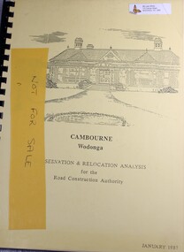
Booklet - Cambourne Wodonga : Conservation & Relocation Analysis for the Road Construction Authority, John & Thurley O'Conner, 1987
... to the acquisition of land in 1972 by the Country Roads Board and in 2006... to the acquisition of land in 1972 by the Country Roads Board and in 2006 ...Research paper into the viability of relocating Cambourne Homestead in 2006 in order to make way for the widening and upgrade of the Hume Highway.non-fictionResearch paper into the viability of relocating Cambourne Homestead in 2006 in order to make way for the widening and upgrade of the Hume Highway. cambourne homestead wodonga, heritage building wodonga, carkeek family, potter family, building relocation -
 Linton and District Historical Society Inc
Photograph, John McDonagh
... of the Woady Yaloak Roads Board, and later a member of the Council... of the Woady Yaloak Roads Board, and later a member of the Council ...Irishman John McDonagh and his wife Martha, nee Mathews, arrived at Port Phillip on the ship 'Oliver Lang' in August 1855. They brought with them their first three children: Martha, Jane and Robert, and also two of John McDonagh's nieces: Jane and Isabella McDonagh, whose parents had died in Ireland. The McDonaghs had five more children in Australia. They lived at Linton from the mid-1860s. In the Ballarat Star [newspaper] in 1867, John McDonagh was described as a "sheep and cattle dealer". He was a member of the Woady Yaloak Roads Board, and later a member of the Council of the Shire of Grenville. John McDonagh died at Linton in 1871. An inquest into his sudden and unexpected death (copy in McDonagh file) concluded he died of apoplexy (= stroke). Part of Old Lintonian Collection ; No. 13.Sepia photograph."John McDonagh"john mcdonagh, old lintonian collection -
 Glen Eira Historical Society
Document - History of the City of Caulfield
... Caulfield Road Board... such as early settlement, Aboriginal influence, Caulfield Road Board..., Caulfield Road Board, Shire of Caulfield, Borough and town ...This file contains 4 items: 1/Typewritten document titled ‘The City of Caulfield’. Author and date unknown. 1 page (back and front), 2 copies. Document covers topics such as origins of the name ‘Caulfield’, early settlement and the Caulfield Cup. 2/Typewritten document titled ‘History of Caulfield Council’. Author and date unknown. 6 pages, 3 copies. Document covers subjects such as early settlement, Aboriginal influence, Caulfield Road Board, Shire of Caulfield, Borough and town boundaries, coat of arms, and Freedom of Entry to the City. 3/Typewritten document (undated + author unknown) titled ‘The Structure of Local Government in Victoria with a history of the City of Caulfield’. 13 pages. Covers the following subjects: Powers, Planning, Public Works, Trading Undertakings, Health Services, Municipalities, Wards Electors or Ratepayers, Voters Roll, Councillors, Officers, Finance, Nature of Soil and Vegetation, Parks and Gardens and Reserves, Coat of Arms, Boundaries, How Did Caulfield get its Name, Aboriginal Influence, Caulfield Road Board, Shire of Caulfield, Borough and Town and the City of Caulfield. Also covered is early settlement. Note at the end of the document mentions that the historical content contained in the last section was based upon a thesis for the Department of Town and Regional Planning, University of Melbourne, 1968 by L. Alwis, P. Rowe, N. Wootten. Melbourne, ‘City of Caulfield: An Illustrated City Report’. 4/Typewritten document (undated) titled ‘The Structure of Local Government in Victoria with notes on the history of the City of Caulfield’. 8 pages, 2 copies. This document also includes a map/diagram of the city with boundaries and wards showing locations of railway stations and parks. Document covers the structure of local government and its functions then goes on to focus on City of Caulfield with subjects similar to those covered in item 3. Document signed off by Deputy Town Clerk.city of caulfield, caulfield john, caulfield baron, caulfield racecourse, elsternwick, ripponlea, st. mary’s church, caulfield council, kooyong road, neerim road, bambra road, greenmeadows house, caulfield park, paddy’s swamp, dandenong road, caulfield grammar school, chisholm institute of technology, murrumbeena, glen eira road, alma road, orrong road, balaclava road, inkerman road, ‘grosmont’, caulfield school room, caulfield road board, caulfield road district, crimean war, victorian amateur turf club, caulfield cup, glenhuntly road, north road, glenhuntly station, ormond station, outer circle railway, local government, gardenvale, carnegie, rosstown, poath road, nepean highway, hotham street, ormond park, princes park, ross william murray, caulfield institute of technology, ‘ross’ folly’, hawthorn road, glenhuntly, ormond, morris t. w., lloyd charles du plan, meals on wheels, shire of caulfield, caulfield railway station, caulfield rsl, bouran road, murrum murrumbeen, kooyong road, great dandenong road, neerim road, trams, prahran and malvern tramways trust, fisher andrew, mackinnon reserve, dover street, ‘glen eira’, blair max cr., insignia, third ordnance services unit, schools, street lighting, lampriere, mr. bevan, the caulfield leader, davies j. henry, curraweena road, st. georges road, o’neill college, hope george, market gardens, koornang reserve, packer reserve, murrumbeena reserve, hopetoun gardens, greenmeadows gardens, mirambeena, caulfield technical college, hart john, langdon h. j., ‘rosecraddock’, judge webb, ‘crotonhurst’, service james, ‘kilwinning’, ricketson henry, grimwade frederick sheppard, airdrie, jenner, st. aubin’s, caulfield john p. t., harlston, lempriere, lord reserve, ‘cantala’ -
 Mont De Lancey
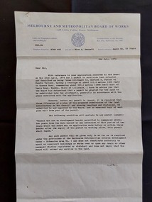
Document - Land Permit to Subdivide Land, Melbourne and Metropolitan Board of Works, 5th July 1974
... ) Assistant Secretary' for 'Mr. M. H. Proctor, Queens Road, Wandin..., Queens Road, Wandin, 3139. 'Board's Reference: Appln No, TP 76484 ...Vintage legal documents for land division in Victoria, especially those predating the Torrens system (October 1862), are often found in the Public Record Office Victoria (PROV). These documents, like deeds and Crown grants, can help trace the history of land ownership and division. A letter from the Melbourne and Metropolitan Board of Works stating the application by Mr M. H. Proctor of Wandin dated 23rd April, 1974 for a permit to subdivide land in Wandin Yallock has been approved by the Board on 23 April, 1974. There are conditions required. The letter is signed: 'Yours faithfully, (O.T. W. Cosgriff) Assistant Secretary' for 'Mr. M. H. Proctor, Queens Road, Wandin, 3139. 'Board's Reference: Appln No, TP 76484'legal documents, contracts, documents, indentures -
 Eltham District Historical Society Inc
Photograph - Digital Photograph, Marguerite Marshall, Wingrove Cottage, Main Road, Eltham, 8 June 2006
... eltham road district board... to the Eltham District Road Board and Shire Council from 1858 to 1904... to the Eltham District Road Board and Shire Council from 1858 to 1904 ...Wingrove Cottage built 1858-1859 of hand made bricks is historically significant for its long association with Charles Wingrove, a prominent figure in Victorian local government, as secretary to the Eltham District Road Board and Shire Council from 1858 to 1904, and Shire Engineer and Secretary to the Heidelberg Road Board. The cottage was used as the office of the Eltham District Road Board and Council for many years It is one of the Shire's oldest dwellings, and one of the few surviving 19th century buildings associated with early Eltham and located in the original Eltham Village Reserve. The symmetrical planting of a pair of Pencil Pines (not visible in photo) is also historically and aesthetically significant as characteristic of the early period of planting in the district and because they are a distinctive landscape feature. In October 2002 new owners demolished the outbuildings attached to the rear of the cottage. Community protest at the demolition resulted in Council issuing a Stop Work order. The owner was issued with a court order in September 2003 to develop a conservation management plan and restore the heritage listed property. The owner sold the property in 2005 to Cameron Construction in 2005 who undertook the restoration work. In 2007 a planning application to build two offices and seven dwellings at the rear of the property was ultimately rejected. The cottage is now the main office for Cameron Construction. Covered under Heritage Overlay, Nillumbik Planning Scheme. Published: Nillumbik Now and Then / Marguerite Marshall 2008; photographs Alan King with Marguerite Marshall.; p57 Wingrove Cottage on Main Road beside Eltham Primary School, is one of the Shire’s most important historical buildings and was central to local government for almost 50 years. The cottage was built in stages from 1858 to 1888 for Charles Symons Wingrove JP. He was the Eltham District Road Board’s first paid secretary and later the Shire Secretary when the board became the Eltham Shire Council. Wingrove held those positions, and that of engineer for a time, for 46 years. He was also one of the main figures in the Municipal Association of Victoria. As Eltham’s first paid municipal officer, Wingrove used one room in his 11 – (originally two) roomed home, as the office for the board then the council. Meetings were held there from the late 1850s (as well as at more central locations) until Wingrove’s retirement in 1904. The cottage is a rare example of a local government office occupying a Road Board /Shire Secretary’s purpose-designed house. The cottage is also significant because it is the oldest largely intact building from the original Eltham township reserve (south of Dalton Street).1 The township had its origins in the 1848 Nillumbik Parish Plan and was one of the state’s earliest township reserves. The rectangular house of handmade bricks, roofed with grey slate tiles and with a veranda encompassing three sides, is reminiscent of those in the central goldfields including Castlemaine. Its overhanging eaves and gables were unlike houses in Melbourne at the time. Wingrove, who was born in 1827, had been a gold digger and a road surveyor. Impossible to imagine in today’s world, Wingrove was also the Shire of Heidelberg’s secretary and engineer for part of the time that he was secretary in Eltham. Living next door to the primary school was a mixed blessing. Wingrove and his wife Katherine, who had ten children, sent their eight surviving children to the school. But they had occasional disputes with the school authorities when their cattle wandered into the schoolyard. Eltham showed Charles Wingrove its appreciation of his services by giving him two illuminated addresses, one after ten years and the other at retirement. Wingrove died in 1905 aged 76 and was buried in the St Katherine’s Church of England cemetery in St Helena. His grave is surrounded by those of family members including his wife, Katherine and two babies, Henry, 12 months and Isobella, 15 months, who died in the mid-1860s. Cottage ownership passed to his wife, then to daughter Caroline and then to daughter Bessie, a Melbourne University graduate and artist. During the Great Depression their brother Walter was the ratepayer. At one stage the Wingrove property extended to Metery Road and included a small creek. The family ran a small dairy and orchard, with associated farm buildings, which were later removed. In 1949 part of the property was compulsorily acquired by the Eltham Primary School, which infuriated owner Bessie Wingrove. She protested in a letter about this ‘monstrous act of unmitigated tyranny’.2 She was the last Wingrove to occupy the cottage and died in 1955. Wingrove descendants sold the house in 1974 and the property was subdivided. In the 1960s the Eltham Shire named the park opposite the cottage in Wingrove’s honour. The cottage has since had several owners including psychiatrist Dr Daniel Kahans, who practised there. In October 2002 late rear additions which had been substantially altered were demolished contrary to council planning controls. This caused a community outcry and resulted in legal proceedings against the owner. Fortunately the historical significance of the demolished section was not as great as the older front part of the building, which has been retained and was later restored.This collection of almost 130 photos about places and people within the Shire of Nillumbik, an urban and rural municipality in Melbourne's north, contributes to an understanding of the history of the Shire. Published in 2008 immediately prior to the Black Saturday bushfires of February 7, 2009, it documents sites that were impacted, and in some cases destroyed by the fires. It includes photographs taken especially for the publication, creating a unique time capsule representing the Shire in the early 21st century. It remains the most recent comprehenesive publication devoted to the Shire's history connecting local residents to the past. nillumbik now and then (marshall-king) collection, cameron construction, charles symons wingrove, eltham, eltham road district board, eltham shire council, main road, wingrove cottage -
 Eltham District Historical Society Inc
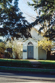
Slide - Photograph, Eltham Courthouse, 730 Main Road, Eltham, c.May 1988
... Road Board and as an overflow classroom for the local school... Road Board and as an overflow classroom for the local school ...Built in 1860, the Eltham Courthouse is the oldest public building remaining in Eltham. In its early days the building was used as the meeting place and office of the Eltham District Road Board and as an overflow classroom for the local school. The Eltham Courthouse ceased operational duties in 1984 and is now used by various community groups including Eltham District Historical Society. It was listed on the Victorian Heritage Register (Number H0784) in 1982. The building is of architectural significance because it retains intact early features. These include use of handmade bricks, simple decoration, roof trusses, timber ceiling boards, original windows, doors and associated hardware and a collection of court furniture. Additions to the court house have been done in a manner which did not interfere with the fabric of the original building. It is a fundamental asset in the Eltham Justice Precinct and is being fully restored in 2021 thanks to Nillumbik Shire Council.35mm colour positive transparency (1 of 23) Mount - Kodak EktachromeProcess Date MAY 88Meltham, eltham courthouse, main road -
 Orbost & District Historical Society
black and white photograph, mid 1930s
... was built by the Country Roads Board in two stages between 1931-36... was built by the Country Roads Board in two stages between 1931-36 ...This is a photograph of McKillop's Bridge probably taken just after its rebuilding. The current McKillop’s Bridge was built by the Country Roads Board in two stages between 1931-36, during which its height was raised after the original bridge superstructure was washed away in record floods of January 1934, prior to its original official opening. In its reconstructed form the original concrete abutments were turned into additional piers and the welded-steel trusses were cantilevered back over them to meet the new higher road approaches. "McKillops Bridge was Heritage listed due to its social and technological significance – the steel trusses' arc-welded construction technique was a pretty big deal in the 1930s. It was once an important route for cattlemen, who used the ford across the Snowy in the years preceding the bridge's existence"This is a pictorial record of McKillop's Bridge just after its construction.A black / white photograph of a wooden bridge across a river. At the bottom right is a man with his back to the camera. He is looking at flood debris on the bank. At the bottom left are two men near a pylon.on back - McKillops Bridgebridge-mckillop's snowy-river-bridge -
 City of Whittlesea
Document - Correspondence, Council letter to Mrs Moses Thomas 1868, 1878
... for the Morang District Road Board. In this role he would have been... for the Morang District Road Board. In this role he would have been ...In 1851 Moses Thomas purchased 400 acres, including a half mile frontage to the Plenty River, at Mernda (then known as Morang) where he operated a farm, inn and other business. In 1865 Moses Thomas was appointed Engineer, Clerk and Collector for the Morang District Road Board. In this role he would have been responsible for overseeing the collection of local property rates and the maintenance and construction of local roads and drains. Road District Boards were one of the earliest forms of local government in Victoria. The Morang or Upper Plenty Road District was established in 1862. It covered part of what is today Mernda, Doreen, South Morang, Mill Park and Bundoora. In 1875, the area merged with the Whittlesea Road District to form the Shire of Whittlesea. Moses Thomas briefly served as a Councillor with the Shire of Whittlesea until his death in 1878. Correspondence. Letter, paper, handwritten text with seal. Letter from James Ryan, Shire Secretary, Shire of Whittlesea to Mrs Moses Thomas on the death of Moses 18 May 1878. -
 Kew Historical Society Inc
Photograph, Chipperfield's Boat House & Floating Pontoon, 1934
... was in the 1850s administered by the Borondara Road Board... administered by the Borondara Road Board. This was compounded ...Living with natural processes was frequently a challenge to early European settlers and later residents of what was in the 1850s administered by the Borondara Road Board. This was compounded by the area being bounded on three sides by rivers (Yarra River, Koonung Creek and Gardiner's Creek). In 1849, the historian James Bonwick recorded that "our district [Kew] suffered considerably. Mr Wade speaks of 80 acres, out of 100 acres of his cultivated paddock, covered by water." Newspapers continued to describe major flooding in Kew in 1863, 1869, 1878, 1880, 1889, 1891, 1916 and 1934. While the construction of the Upper Yarra dam in 1957 reduced the levels of flowing downstream, local and riverine floods continue. A number of boat houses operated on both sides of the River Yarra at Kew. Chipperfield's Boat House was located on the Yarra near the corner of Kilby and Willsmere Roads.The Kew Historical Society's pictures and map collections testify to the impact of flooding in the district. They have historical importance in documenting the extent of flooding in the district and its affects on homes, services and recreation. Numerous photographs record flooding throughout the Twentieth Century.Floating pontoon at Chipperfield's Boat House where the canoes were stored, taken in 1934, presumably before the 1934 Flood. This area of the Yarra was shallow with a number of mid river sandbanks and a popular swimming area for locals.yarra river, chipperfield's boathouse, pontoon -
 Wodonga & District Historical Society Inc
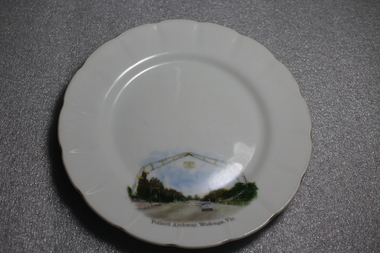
Memorabilia - Souvenir Plate Pollard Arch, Wodonga, Victoria, C. 1960s
... for £1230. When the Country Roads Board said the causeway would have... the Country Roads Board said the causeway would have to be duplicated ...A wide range of souvenirs have been produced to commemorate Wodonga and its landmarks over time. These items document key changes in Wodonga and its heritage. The arch is named in honour of Cr Charles Pollard, a foundation member of the Wodonga Show Society and former Wodonga Shire councillor and president. The arch is 29 metres wide and 15 metres high and consists of two boomerangs coming together to form an archway. Originally spanning across a single carriageway of the Lincoln Causeway, the arch was opened by Princess Alexandra of Kent in 1959 and was built for £1230. When the Country Roads Board said the causeway would have to be duplicated in 1973, a new home was required for the arch. At the request of the Wodonga Show Society, the arch was moved to the entrance of the showgrounds in 1982. After development of the precinct in 2015, the Pollard Arch was erected on Hamilton Smith Drive Wodonga.Small china pieces carrying scenic views of holiday destinations were a popular kind of souvenir during much of the 20th century. These items have local and social significance as they reflect the landmarks or local features valued by the community over time.Fine china round plate, white with image of the Pollard Archway in Wodonga, Victoria in the bottom third of the plate. Inscription below the image.On bottom of image "Pollard Archway, Wodonga, Vic". Manufacturer's mark on back "St Kilda/ Fine China/ Australia / Hand Painted"souvenir, wodonga, victoria, pollard archway, landmarks wodonga -
 Melbourne Tram Museum
Pamphlet, Minister of Transport, "Transport Victoria", 1977 and 1978
... Underground Rail Loop Authority - MURLA Country Roads Board - CRB... Underground Rail Loop Authority - MURLA Country Roads Board - CRB ...453.1 - Sixteen page, full colour printed on glossy paper, centre stapled pamphlet, titled "Transport Victoria", with part of the Harold Freedman on the front cover, detailing the structure and the authorities of the Ministry of Transport, c1977. Foreword by Hon. J. Rafferty Transport Minister (1976 to 1978 - State Parliament website biography). Provides information on: MMTB Victorian Railways - VicRail Railway Construction Board Melbourne Underground Rail Loop Authority - MURLA Country Roads Board - CRB Transport Regulation Board - TRB Westgate Bridge Authority and who's who in the transport in Victoria - Board members - with photos. 453.2 - as above but with foreword by Robert Maclellan MLA as minister (see image 9) and revision of the "Who's who" on page 15 - see image 10. Maclellan was the Minister was 1978 to 1982 - parliamentary web site. Not imaged..trams, tramways, mmtb, minister for transport, vicrail, crb, murla -
 Orbost & District Historical Society
postcard, C1920-1940
... , a joint Country Roads Board — Victorian Railways venture..., a joint Country Roads Board — Victorian Railways venture ...This photograph shows the second major bridge across the Snowy River at Orbost. The current Snowy River bridge is the fourth to provide a crossing to the township of Orbost. The first, in 1891, lasted just two years before it succumbed to flood waters. The bridge in this photograph was built in the 1920s as a road and rail bridge, and was again partly washed away by flood waters in 1934. After the end of the first World War the Victorian Railways considered an extension of the railhead across the river at Orbost, and in 1922 a new timber and steel girder structure, a joint Country Roads Board — Victorian Railways venture, was built and completed at a cost of £41,000 (the steel girders came from the Flinders Street viaduct reconstruction). Subsequently it was decided not to take the railway across the river, and the bridge was only used by road traffic. It was severely battered by floods during its life. and after the 1971 floods was eventually replaced by the current bridge in 1975. (info from Newletter 54N by John Phillips) This item is an early pictorial record of the previous Snowy River bridge at Orbost.A postcard with a black / white photograph of a bridge - timber and steel girder structure - across the Snowy River at Orbost, Reflections of the bridge are seen in the water.snowy-river-bridge-orbost -
 Surrey Hills Historical Society Collection
Photograph, Winifred and Mildred Jacobs of Surrey Hills
... was appointed to the Nunawading Roads Board in 1900; in 1902 he...). Capt Jacobs was appointed to the Nunawading Roads Board in 1900 ...The Jacobs family lived in Surrey Hills from c 1895-1903 (ref: electoral rolls); by 1909 they were in Gippsland at Toora where Henry Atwood Jacobs was a storekeeper. They had returned to Surrey Hills by 1924 (ref: electoral roll). Capt Jacobs was appointed to the Nunawading Roads Board in 1900; in 1902 he as a member of a deputation to the Minister of Public Works regarding municipal severance. He was in favour of Surrey Hills being a separate municipality. Amy (Amelia) Jacobs was the daughter of Capt Jacobs and his first wife, Eleanor Dobson Mills, who died shortly after the birth of her daughter. Winifred was born c 1900; Mildred Adelaide b 1902, both at 'Spencycroft' in Canterbury Road, Surrey Hills. Winifred married Stephen Edwin Yarnold (1903-1978), a Presbyterian & Uniting Church minister on 26 July 1946. He had a notable career in the ministry and has an ADB biography.Black and white photo of 2 young girls identified as Winifred (b c1900) and Mildred (b 1902) taken in a garden, probably at 'Spencycroft'. Both are wearing dresses and dark stockings. The older girl is holding her sister's arm.spenceycroft, house names, gardens, surrey hills, children, winifred jacobs (miss), stephen edwin yarnold, winifred yarnold (mrs), mildred adelaide jacobs (miss), henry atwood jacobs, capt, eleanor dobson mills (miss), eleanor dobson jacobs (mrs) -
 Bacchus Marsh & District Historical Society
Map, Plan of part of the road district of Bacchus Marsh circa 1856-1862
... Board regarding plans for road construction. Road construction... Board regarding plans for road construction. Road construction ...Local government in much of Victoria including the Bacchus Marsh area began with the formation of 'local committees'. These local committees could make representations to a Central Road Board regarding plans for road construction. Road construction and maintenance were seen as the essential tasks of these early local government authorities. By 1856 the local committee in Bacchus Marsh was constituted as the Bacchus Marsh Road District. This entity continued until 1862 when the name changed to the Bacchus Marsh and Maddingley Road District. This new entity lasted until 1871 when the local government authority in accordance with new statewide legislation became known as the Shire of Bacchus Marsh. The title of this plan being a plan of 'a portion of the road district of Bacchus Marsh' suggests that the plan was produced sometime between 1856 and 1862. The main purpose of this map was to shown the irrigable land in the district and the sources from which water for irrigation could be drawn. Bacchus Marsh was an early irrigation district in Victoria. Irrigation trusts were formed in the 1880s and 1890s to manage irrigation districts. But this was the culmination of many years of earlier attempts to construct irrigation systems in the Bacchus Marsh area and create a system to manage irrigation more broadly. This map dating from around 1856-1862 is an important cartographic document which provides evidence of how the early planning for irrigation was developing in the Bacchus Marsh region.A single page paper map showing a plan of part of the road district of Bacchus Marsh. The map is pasted into a bound volume containing 76 maps or plans in total. High resolution digital image stored on BMDHS computer network. bacchus marsh victoria maps, bacchus marsh road district, local government, road districts, irrigation -
 Eltham District Historical Society Inc
Folder, Pioneers & Painters; Shire of Eltham Historical Society research notes, background information, etc, 1969-1986, 1969-1986
... eltham district road board..., 25 June 1969 04768-3 Notes on Eltham District Road Board..., 25 June 1969 04768-3 Notes on Eltham District Road Board ...Material pertaining to the production of a history of the Shire of Eltham, "Pioneers & Painters: One Hundred Years of Eltham and its Shire" in recognition of the shire's centenary in 1971 Item Title Caption 04768-1 Newspaper clipping - The Eltham of 1905; Gellibrand our first white visitor? Diamond Valley News, 24 June 1969, p5 04768-2 Newspaper clipping - The Eltham of 1905; Gellibrand our first white visitor? Heidelberger, 25 June 1969 04768-3 Notes on Eltham District Road Board Members 1866-1871 04768-4 Notes on Eltham District Road Board Members 1866-1871 04768-5 Map showing Gellibrand's likely route through district 12-13 February 1836 and Hoddles's route of Febrary 1838 04768-6 Notes by Shire Secretary, M.B. Watson regarding meeting with Reverend Longfield regarding history of St Margaret's Church 04768-7 Alan Marshall's notes from discussion with Mr. F. Barrett regarding SEPP images 611, 635 and 636 SEPP_0611 SEPP_0635 SEPP_0636 04768-8 Transcripts of letter from local residents to Charles Joseph Latrobe requesting a bridge over the Plenty River dated 10 April 1849 and his reply dated 5 May 1849; from Latrobe Library Archives - Land Branch Records 04768-9 Notes on history of Eltham Shire, Centenary events and publication of Pioneers & Painters for release in conjunction of opening of new Library 04768-10 Newspaper clipping - Glossy record of shire's romantic past and the people who made it by Fab Calafuri, Diamond Valley News, Tuesday, December 16, 1986, p18 SEPP_0755-3 Letter: Acknowledgement from Colin J. Bock, Eltham Shire Secretary to A.R. Thomas of Bendigo for copy of 1913 photograph of Shire of Eltham Councilors, 21 May 1973 A.R. Thomas' father Mr. A.G. Thomas, C.E., was the Shire Secretary at the time in 1913. Cross Ref: SEPP_0755 The idea to develop a book on the history of the Shire of Eltham to be edited by noted author, Alan Marshall in celebration of the shire's centenary was initiated in 1969. The Shire of Eltham Historical Society undertook significant research in conjunction with Alan Marshall locating material at various institutions and other societies; interviewing longer term residents and a public campaign through the local press to acquire photographic material for duplication and use in the book. The public campaign received generous response and the material collected became the genesis for the Shire of Eltham Pioneers Photograph collection now held in partnership between Eltham District Historical Society and Yarra Plenty Regional Library (Eltham Library).Paper documents of various sizes and newspaper clippingsa.g. thomas, a.r. thomas, alan marshall, bridge road, charles joseph latrobe, council members, d.w. lachlan, eltham district road board, eltham shire council, ernie orford, f. barrett, francis rogerson, g. bransprone, james donaldson, james johnston, john bell, john thomson, joseph tice gellibrand, lower plenty bridge, m.b. watson, main road, map, patrick turnbull, peter morris, pioneers and painters, post office, rev. longfield, sepp, shire of eltham pioneers photograph collection, shire secretary, st margaret's church, thomas armstrong, thomas bell, thomas sweeney, william bell (1796-1870), centenary celebrations, christmas hills, clifton pugh, david newbury, dudley street, eltham, gareth jones roberts, hurstbridge, john perceval, joy peck, kangaroo ground, kinglake, lower plenty, luther haley general store, montmorency, neil douglas, panton hill, peter glass, research (vic.), sheila ferguson, shire of eltham, st andrews, yarra glen -
 Orbost & District Historical Society
black and white photograph, 1971
... , a joint Country Roads Board — Victorian Railways venture..., a joint Country Roads Board — Victorian Railways venture ...This photograph shows the second major bridge across the Snowy River at Orbost. The current Snowy River bridge is the fourth to provide a crossing to the township of Orbost. The first, in 1891, lasted just two years before it succumbed to flood waters. The bridge in this photograph was built in the 1920s as a road and rail bridge, and was again partly washed away by flood waters in 1934. After the end of the first World War the Victorian Railways considered an extension of the railhead across the river at Orbost, and in 1922 a new timber and steel girder structure, a joint Country Roads Board — Victorian Railways venture, was built and completed at a cost of £41,000 (the steel girders came from the Flinders Street viaduct reconstruction). Subsequently it was decided not to take the railway across the river, and the bridge was only used by road traffic. It was severely battered by floods during its life. and after the devastating 1971 floods was eventually replaced by the current bridge in 1975. (info from Newletter 54N by John Phillips)This is a pictorial record of the flood damage in 1971 when part of the Snowy River Bridge was washed away.A black / white photograph of a bridge which has been damaged by floodwaters. It shows one end has been washed away.orbost-snowy-river-bridge-1971 floods-orbost-1971 -
 Warrnambool and District Historical Society Inc.
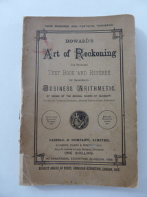
Book, Art of reckoning, 1892
... was the first district secretary of the Moorabbin Roads Board. He... district secretary of the Moorabbin Roads Board. He absconded ...This book was written by C. Frusher Howard in 1874 and this copy is the 1892 edition. C. Frusher Howard was the alias of Joseph Ostler (‘Frusher’ was his mother’s maiden name) and he was the first district secretary of the Moorabbin Roads Board. He absconded with its funds in 1867. After some time in the goldfields of U.S.A. and a bigamous marriage he published ‘The Art of Reckoning’ which was highly successful in Britain and U.S.A. He was able to pay back the money he had embezzled. He advertised that he was a Fellow of the Society of Science, Letters and Art, London, but this was a profit-making society owned by an individual and enabled members to wear academic dress and use the title of ‘Professor’. Ostler had in reality no academic qualifications. In the early 1890s he lectured on his ideas on mathematical calculation and publicized his four books in India, Egypt, Palestine and South Africa. In 1896 he returned to Australia and at the 1896-7 Warrnambool Industrial and Art Exhibition Howard gave daily lectures on mathematical calculations and illustrated these with the aid of a blackboard. The inscription in this book does not appear to have any local significance but the book is of interest because the author, C. Frusher Howard, was a lecturer at the Warrnambool Industrial and Art Exhibition of 1896-7. This is a soft cover book of 142 pages. There are several pages at the back of the book advertising other books published by Cassell and Company. The cover is brown with an ornate border on the front cover and black printing on the front cover, spine and back cover. The lettering on the spine has been mostly worn away. The first page has a black and white sketch of the author, C. Frusher Howard, in academic dress. The inscription is handwritten in black ink. ‘C.F. Hamilton, South Heathcote, 1893’ c. frusher howard (joseph ostler) -
![W. D. Birrell, Town Clerk [Kew] 1936 -](/media/collectors/550653872162f11fb04854aa/items/5922c01dd0cde9131c35460b/item-media/5c22673821ea6713f45cc993/item-fit-380x285.jpg) Kew Historical Society Inc
Kew Historical Society IncPhotograph, Stuart Tompkins Studios, W. D. Birrell, Town Clerk [Kew] 1936, c.1938
... . Birrell, who had been on the staff of the Country Roads Board..., who had been on the staff of the Country Roads Board after his ...In Kew’s Civic Century (1960), Cr. W.D. Vaughan described William Dickie Birrell M.B.E. (1899-1974) as follows: “Mr. W. D. Birrell, who had been on the staff of the Country Roads Board after his return from active service with the First A.I.F., was appointed assistant town clerk on February 15, 1921. On Mr. Harrison’s retirement he was appointed town clerk and city treasurer, and has given outstanding service. His knowledge of municipal administration has been acknowledged by the Government calling on his services to advise on amendments to the Local Government Act. He is a past president of the Town Clerks Institute, and on the nomination of that body was honoured by Her Majesty the Queen in 1958 with the award of the M.B.E. He still occupies the position and is held in the highest esteem not only by the Kew Council, but also by local government administrators throughout the metropolitan area.” (page 132) He died on 7 May 1974, and his ashes were interred at the Boroondara General Cemetery. This portrait is one of a series of mounted and framed photographic portraits of Mayors and Town Clerks of the former Borough, Town and City of Kew, for the period 1863 to 1969. The portraits were transferred by the City of Kew to the Kew Historical Society in March 1989. A Significance Assessment in 2018, funded by the National Library of Australia confirmed the historic, and often artistic significance of the series. Framed portrait of W. D. Birrell - Town Clerk of the City of Kew from 1936 -. The mounting and framing of the photograph follows a typical layout or style in that it each is framed in dark wood, glazed, and laid down on an inscribed board. The inscription identifies the name of the town clerk and the year/s that he served.W.D. BIRRELL / TOWN CLERK 1938-town clerks - kew (vic), w.d. birrell, photographers - stuart tompkins studios - camberwell (vic), kew (vic.) — municipal collection -
 Eltham District Historical Society Inc
Photograph, Ewen Hugh Cameron (1832-1915), c.1910
... was a member of the Eltham Roads Board and later Council for more than... was a member of the Eltham Roads Board and later Council for more than ...Ewen Hugh Cameron (1831- 27 September 1915) was born at Kilmonivaig, Inverness Scotland. He migrated to Melbourne in “The Hurricane” in 1853 and in 1855 tried his luck at the newly-opened Andersons Creek Goldfield. Two years later he was appointed first postmaster at Warrandyte and ran the store there. In 1863 he took up the 100 acre farm “Pigeon Bank” at Kangaroo Ground where he lived until his death. In 1874 Cameron was elected as the Member for Evelyn in the Victorian Legislative Assembly and held the seat until he retired in 1914 as “Father of the House”. He held a number of ministerial and other important Parlimentary positions. The most notable was Chairman of the Railways Standing Committee, which was responsible for much of the Railway development in Victoria. Concurrently with his Parliamentary career, he was a member of the Eltham Roads Board and later Council for more than 50 years. In 1867 he married Agnes Bell, a daughter of Kangaroo Ground pioneers. They had eight sons and three daughters. This photo forms part of a collection of photographs gathered by the Shire of Eltham for their centenary project book,"Pioneers and Painters: 100 years of the Shire of Eltham" by Alan Marshall (1971). The collection of over 500 images is held in partnership between Eltham District Historical Society and Yarra Plenty Regional Library (Eltham Library) and is now formally known as the 'The Shire of Eltham Pioneers Photograph Collection.' It is significant in being the first community sourced collection representing the places and people of the Shire's first one hundred years.Digital image B&W printsepp, shire of eltham pioneers photograph collection, kangaroo ground, e.h. cameron, member for evelyn, victorian parliament, legislative assembly, ewen cameron, ewen hugh cameron, ewan hugh cameron, people, pigeon bank