Showing 490 items
matching colonial melbourne
-
 Stawell Historical Society Inc
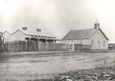
Photograph, Presbyterian Church, Reefs Pleasant Creek, built 1860
Presbyterian Church Reefs Pleasant Creek. Built 1860. Part of a collection of Photographs by Mr. O.G. Armstrong as commissioned by the Shire of Stawell in 1866 for the Inter-colonial and Paris Exhibition in Melbourne in 1866. This first Presbyterian church was built in Church Street and was of a modest design as it was to be only a temporary house of worship. The first services were held here on Sunday, August the 23rd, 1860. The present church, St Matthews Uniting Church is situated in Scallon Street and the first service were held there in 1869. House on left with picket fence and striped verandah roofing. Wooden Church Building on right.stawell religion -
 Stawell Historical Society Inc
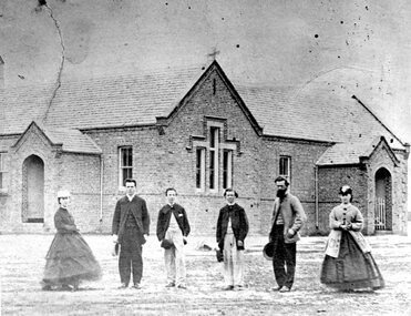
Photograph, Pleasant Creek Hospital 1866
Pleasant Creek Hospital. Part of a collection of Photographs by Mr. O.G. Armstrong as commissioned by the Shire of Stawell for the Inter-colonial and Paris Exhibition in Melbourne in 1866. Due to a public outcry for medical services on the goldfield a public meeting was held in the Olympic Theatre at Deep Lead on the 7th of August 1858. It appointed a 50 man committee to establish a hospital at Pleasant Creek. A temporary Tent structure was soon erected at Doctors Hill, situated midway between Deep Lead and Commercial Street Pleasant Creek, just South of the later Western Highway. The site is now marked by a commemorative stone. Within two months the committee had collected £600 in subscriptions, a government Grant for £2500 and acquired 10 acres of land. The foundation stone of the hospital building was laid on 21st December 1860 and the building completed and occupied by 21st June 1861. In the 1930’s the hospital moved to the centre of Stawell in Sloane Street and the buildings then taken over by the Pleasant Creek Training Centre. Brick hospital building with two ward wings and central front door. Man standing on steps.stawell health -
 Stawell Historical Society Inc
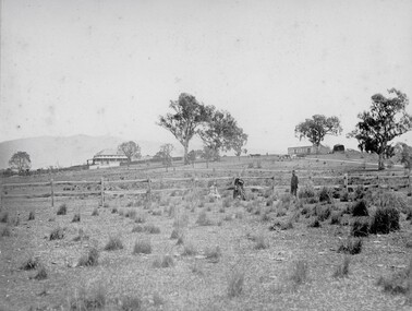
Photograph, Ledcourt Home Station in the Grampians 1866
Ledcourt Home Station Grampians. Part of a collection of Photographs by Mr. O.G. Armstrong as commissioned by the Shire of Stawell for the Inter-colonial and Paris Exhibition in Melbourne in 1866. This was one of, if not the first, Squatters Sheep Station in this region. The first licence of Ledcourt was granted to Robert Briggs in about 1840. In 1842 the run passed to Benjamin Boyd of Whaling and Boydtown Banking fame in NSW. He held it for six years. It was then taken over by Thomas Young and John Carfrae, who divided it into 3 holdings. Ledcourt 74,500 acres, Newington 74,500 acres and Swinton, 52,000 acres. It again changed hands in 1859, this time to Henry Alfred and Joseph De Little. It has changed hands several times since and in later years owned by the Cooper family and now the Marr family. The date of the actual building is uncertain, but it is known that the stone used in the building was carted from the Mount Difficult area in the Grampians and some of the courtyard paving shows convict origin. Looking up hill with Homestead on left and stone stables or right.stawell -
 Stawell Historical Society Inc
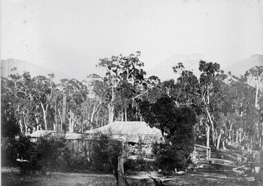
Photograph, ''Mokebilla" Station 1866
Mokebilla Station. Part of a collection of Photographs by Mr. O.G. Armstrong as commissioned by the Shire of Stawell for the Inter-colonial and Paris Exhibition in Melbourne in 1866. Charles Browning Hall was at the station for a short period in about 1840-41. Horatio Wils purchased Lexington from C.B. Hall in 1842. To this he added the stations of Larose and Mokebilla. Part of the property still remains along the Halls Gap Rd, by the bridge over the Mount William Creek. Note that the spelling has changed over the years and it is currently known as Mokepilly. Looking across water to Homestead and outbuildings behind large Gum Trees.stawell -
 Stawell Historical Society Inc
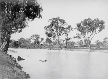
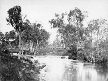
Photograph, Wimmera Falls in Glenorchy 1866
Wimmera Falls Glenorchy. Part of a collection of Photographs by Mr. O.G. Armstrong as commissioned by the Shire of Stawell for the Inter-colonial and Paris Exhibition in Melbourne in 1866. The fact that there was ever a natural waterfall in the Wimmer River would probably be a surprise to anyone who has known the river at all. There are many man-made weirs across it in several places today, one of them at Glenorchy is thought to hide the original falls. A Stawell Paper dated 21st August 1888, refers to them being a mile below the Township. View of river amongst gum trees with shallow falls at centre of photograph.stawell -
 Stawell Historical Society Inc
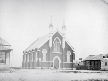
Photograph, Wesleyan Church Main Street, Reefs Opened 1863
Wesleyan Church Main Street Reefs. Opened 1863. Part of a collection of Photographs by Mr. O.G. Armstrong as commissioned by the Shire of Stawell for the Inter-colonial and Paris Exhibition in Melbourne in 1866. This brick church, later known as the Wesley Centre, was opened for service on Christmas Day 1863. It was situated in the Main Street alongside the Town Hall which was constructed in 1872. The church was demolished for a car park in the 1980’s. Brick church building with two ornate towers beside front doors.stawell religion -
 Stawell Historical Society Inc
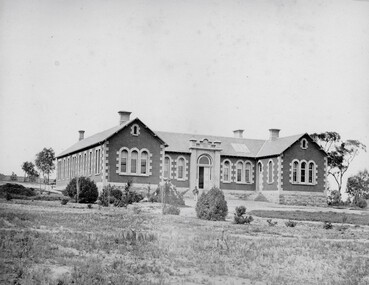
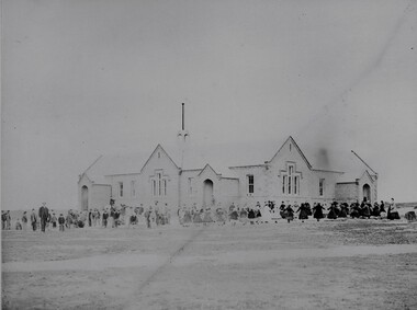
Photograph, Common School Pleasant Creek 502 in 1866
Common School Pleasant Creek 502. Part of a collection of Photographs by Mr. O.G. Armstrong as commissioned by the Shire of Stawell for the Inter-colonial and Paris Exhibition in Melbourne in 1866. The site for the school pictured was reserved in October 1864 and the building was opened in 1865. The brick building is still in use and is at the rear of the current 502 Primary School buildings, Barnes Street. Large brick and stone school building with students and teachers at front.stawell education -
 Stawell Historical Society Inc
Photograph, Grampians Sunrise over the Saw Mills 1866
Grampians (Sunrise over the Saw Mills). Part of a collection of Photographs by Mr. O.G. Armstrong as commissioned by the Shire of Stawell for the Inter-colonial and Paris Exhibition in Melbourne in 1866. The Grampians were first sighted by Major Thomas Mitchell on the 11th of July 1836. Four days later he and a small party climbed its highest peak and named it Mount William. Owing to the lateness of arrival at the summit they had to spend a very cold and miserable night. Whilst in the Grampians, which he so named because of their likeness to his native Scotland. He collected about 150 plants and sent them to the Professor of Botany, John Lindley at the University of London. It is now known there about 900 different flowering plants in the Grampians, over one third of all those growing in Victoria. stawell industry -
 Stawell Historical Society Inc
Photograph, Great Western 1866
Great Western. Part of a collection of Photographs by Mr. O.G. Armstrong as commissioned by the Shire of Stawell for the Inter-colonial and Paris Exhibition in Melbourne in 1866. Great Western began as a changing station on Concongella, northeast of the present Township. The gold rush in Great Western began in 1858 and soon after a post office and store opened. A Township was surveyed and lots sold in October 1858. The gold soon passed and the diggers went on, leaving a small settlement. In 1863 Jean Pierre Trouette and Emile Bampied, his brother-in-law, planted the first vines and build the first winery, thus setting a firm foundation upon which the present wine industry has been built. Telegraph poles and wires visible. Bakery visible in distance on right of road, looking west. stawell -
 Stawell Historical Society Inc
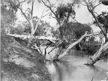
Photograph, Glenorchy Bridge on the Wimmera River 1866
Glenorchy Bridge Wimmera River. Part of a collection of Photographs by Mr. O.G. Armstrong as commissioned by the Shire of Stawell for the Inter-colonial and Paris Exhibition in Melbourne in 1866. Prior to the construction of this bridge in 1860, there existed two forwards across the Wimmer River at Glenorchy. One was 2 miles on the Stawell side of Glenorchy and 500 metres from the present railway bridge. It was well made, stone floor and can be seen today. The second was located 800 metres downstream of the town and was known as Stuart’s Crossing. These Fords were popular crossing spots for Bullock Drays which were delayed for days during floods before the bridge was built. The original Bridge was built near the site of the present ‘old’ bridge. stawell -
 Stawell Historical Society Inc
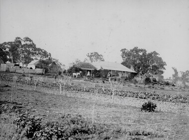
Photograph, Concongella Home Station 1866
Concongella Home Station. Part of a collection of Photographs by Mr. O.G. Armstrong as commissioned by the Shire of Stawell for the Inter-colonial and Paris Exhibition in Melbourne in 1866. The Concongella Station consisted of 57,000 acres along the Concongella Creek. It was first part of Allanvale, taken up by John Allan in 1841. Allen's right to the 137,000 acres of Allanvale was contested and as a result, the northern section of 57,000 acres was renamed Concongella. Concongella Run, with the homestead on the creek of the same name just east of Stawell, occupied the lands between the later named Deep Lead and Great Western. It was on this station that William McLaughlin a sheep minder discovered gold at Pleasant Creek in 1853. Doctor Blundell held Concongella under licence at this time and through until 1858. The homestead has been gone for many years and only some lonely graves remain at this vicinity. stawell -
 Stawell Historical Society Inc
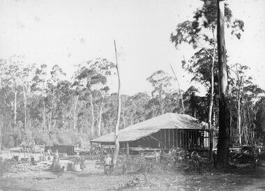
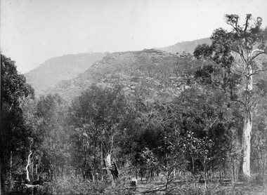
Photograph, Saw Mills at Childe’s Glenbower Creek in Halls Gap 1866
Saw Mills Halls Gap (Childe’s Glenbower Creek). Part of a collection of Photographs by Mr. O.G. Armstrong as commissioned by the Shire of Stawell for the Inter-colonial and Paris Exhibition in Melbourne in 1866. During the years of gold, the hardwood forests around Stawell were ravaged to provide timber for the mines. It was used undergrounds to shore up workings, and millions of feet of it were fed into furnaces and kilns in which the quartz was roasted. In the years after the gold boom, hardwood from the Grampians was milled for building timber. Wherever there are large tracts of natural bushland, fires are always a danger. A huge fire in January 1939 caused havoc in the Grampians, burning out towns and sawmills such as the one pictured. There have been no sawmills in the Grampian since that fire. stawell industry -
 Stawell Historical Society Inc
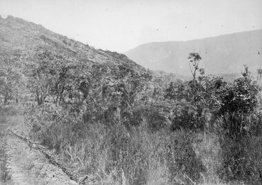
Photograph, Grampians at Halls Gap 1866
Grampians Halls Gap. Part of a collection of Photographs by Mr. O.G. Armstrong as commissioned by the Shire of Stawell for the Inter-colonial and Paris Exhibition in Melbourne in 1866. From about 1860 there was agitation for a water supply, not only for Stawell but for the Wimmer Mallee as well. In 1887 Wartook was adopted as the first reservoir for the Wimmer. Stawells water supply was designed by Mr. John D’Alton. The scheme came from Fyan’s Creek via Wooden Fluming and a Syphon and finally through the mountain in a tunnel, before being piped to a reservoir on Big Hill. The system was completed in December 1881 and although there have been modifications, basically it has not been changed to this day. The Wimmera Mallee stock and domestic system from the Grampians is the largest system of its kind in the world, the latest edition being like Belfield and piping of Wimmera channels. stawell -
 Stawell Historical Society Inc
Photograph, "Barney’s Castle" in the Grampians at Halls Gap 1866
Grampians Halls Gap (Barney’s Castle). Part of a collection of Photographs by Mr. O.G. Armstrong as commissioned by the Shire of Stawell for the Inter-colonial and Paris Exhibition in Melbourne in 1866. In 1880 a branch line from Stawell Railway Yards was built to Heatherly Quarry, to carry stone for part of Parliament House Melbourne, the GPO in Elizabeth St, the Harbour Trust buildings, additions to the Melbourne Town Hall, the Stawell Courthouse Patrick Street and the Stawell Catholic Church in Patrick St. The line was taken over by the Railways Department in June 1905 and was closed in March 1949. It has since been removed but remnants of the machinery and buildings are visible at the quarry site. stawell -
 Stawell Historical Society Inc
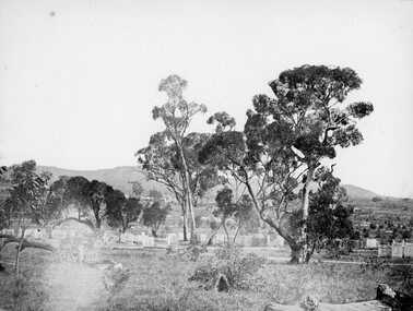
Photograph, Pleasant Creek Cemetery 1866
Pleasant Creek Cemetery. Part of a collection of Photographs by Mr. O.G. Armstrong as commissioned by the Shire of Stawell for the Inter-colonial and Paris Exhibition in Melbourne in 1866. The site of the Pleasant Creek Cemetery was proclaimed on October the 14th, 1861. Prior to that, a cemetery existed on ‘One Tree Hill’ where burials were made as early as 1854. A memorial is located on the site of the One Tree Hill Cemetery, corner of Griffith and Leslie streets, Stawell West. stawell -
 Stawell Historical Society Inc
Photograph, Glenorchy 1866
Glenorchy. Part of a collection of Photographs by Mr. O.G. Armstrong as commissioned by the Shire of Stawell for the Inter-colonial and Paris Exhibition in Melbourne in 1866. Glenorchy township began as a resting place for bullock teams and travellers in the 1840s. In 1847, John Gleeson built the Four Posts Inn, which then became the name of the settlement. Gleeson is credited with naming the settlement Glenorchy, meaning tumbling waters, after his birth place in Scotland. In 1865 the Township consisted of a church, school, three hotels the Four Post Inn built 1847, Royal Hotel built 1855, The Royal Mail Hotel built1862. As well as boot makers, a blacksmith, stores, butcher and other enterprises. The town was a postal centre served by three coaches each day until the advent of the railway. stawell -
 Stawell Historical Society Inc
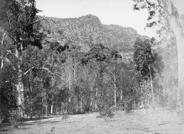
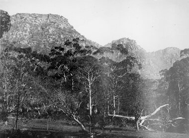
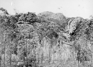
Photograph, Wonderland Range in the Grampians 1866
Grampians (Wonderland Range). Part of a collection of Photographs by Mr. O.G. Armstrong as commissioned by the Shire of Stawell for the Inter-colonial and Paris Exhibition in Melbourne in 1866. The Grampians, with its wildflowers and rock formations, have attracted people from all parts of the world for many years and have always been promoted strongly by local groups. One such group was the Grampians Tourist Association, formed in 1901. Wonderland would probably be the best known part of the whole area, noted for its rugged and weather worn rock formations and spectacular views, too numerous to mention. The Grampians are now a National Park. stawell -
 Stawell Historical Society Inc
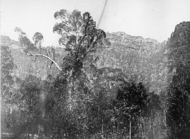
Photograph, Chautauqua Peak in the Grampians at Halls Gap 1866
Grampians Hall’s Gap (Chautauqua Peak). Part of a collection of Photographs by Mr. O.G. Armstrong as commissioned by the Shire of Stawell for the Inter-colonial and Paris Exhibition in Melbourne in 1866. It is recorded in the history of the Presbyterian Church of Stawell, that one fine piece of organisation by Rev. E.C. Tennant in the early 1890’s was a Chautauqua, or religious conference at the Grampians. Many of the religious leaders of Victoria gathered for the purpose of discussion, conference and spiritual enrichment. So great was the impression made, that a peak in the Grampians was named Chautauqua Peak. stawell -
 Stawell Historical Society Inc
Photograph, Grampians Entrance to Halls Gap 1866
Grampians Entrance to Halls Gap. Part of a collection of Photographs by Mr. O.G. Armstrong as commissioned by the Shire of Stawell for the Inter-colonial and Paris Exhibition in Melbourne in 1866. Halls Gap is named after Charles Browning Hall. In his letter to Joseph Latrobe he gives no clue about his early life except that he was a stock herder as early as 1837. He held two runs in the Wimmer district, that of La Rose and Mokebila in the Grampians (1841 to 1842). He then moved to the Clunes area in 1851. He was a member of the Carisbrook Magistrates Bench. stawell -
 Stawell Historical Society Inc
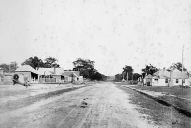
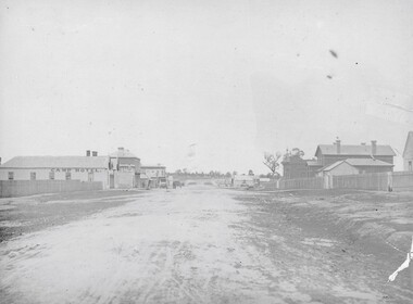
Photograph, Longfield Street / Western Highway 1866
Part of a collection of Photographs by Mr. O.G. Armstrong as commissioned by the Shire of Stawell for the Inter-colonial and Paris Exhibition in Melbourne in 1866. Longfield Street Stawell (now the Western Highway) looking towards Sister Rocks and Ararat. Pleasant Creek Court House and Shire Hall are on the right, as is a shop on the corner of Seaby Street and Longfield streets. On the left is the Camp Hotel, the Constitution Hotel and the Shamrock Hotel on the far Side of Seaby Street. stawell streetscape -
 Stawell Historical Society Inc
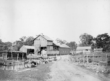
Photograph, Fountain Head Brewery at Armstrong 1866
Fountain Head Brewery Armstrong's. Part of a collection of Photographs by Mr. O.G. Armstrong as commissioned by the Shire of Stawell for the Inter-colonial and Paris Exhibition in Melbourne in 1866. The brewery, a three-storey high building, was established close to two streams which joined the Concongella Creek near Armstrong, although the water required to run the brewery was obtained from a natural underground spring which is still visible. Further findings of Gold in Victoria around 1859-1860 brought a large rush of miners to the area. Some stayed on to become merchants, farmers, etc. Jens Kofoed, a shipwright from the Netherlands, was one who came to the area at this time. He and his family move to Armstrong in 1860, establishing the Fountain Head Brewery, which employed quite a number of people for about 40 years. stawell industry -
 Stawell Historical Society Inc
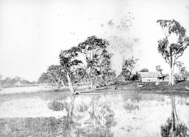
Photograph, "Schoolers" Homestead at Lake Lonsdale 1866
Schoolers Homestead Lake Lonsdale. Part of a collection of Photographs by Mr. O.G. Armstrong as commissioned by the Shire of Stawell for the Inter-colonial and Paris Exhibition in Melbourne in 1866. Similar Photo Scoullar station Rosehill Cat No 3888 G.F. Scoullar originally from Canada, according to W.G. Sharply in his 1930 Stawell Borough History, was a member of the Stawell Shire Council 1870-1888 and president 1875-1876. Maynard Ord in Stawell Past and Present says G.F. Scoullar, M. Brinkman and one other, took up small pieces of land fronting Lake Lonsdale. The owners of the Squatting Run, presumably Ledcourt, charged them with illegal occupation. They were heavily fined at Pleasant Creek Court, or in default gaol. As they could not afford the fine, some friends raise the money. Note re the spelling of ‘Schooler’. Variations in local records are ‘Schoullar’ and ‘Scoullar’. stawell education -
 Stawell Historical Society Inc
Photograph, Wonderland Range in the Grampians at Halls Gap 1866
Grampians Halls Gap (Wonderland Range). Part of a collection of Photographs by Mr. O.G. Armstrong as commissioned by the Shire of Stawell for the Inter-colonial and Paris Exhibition in Melbourne in 1866. Although little is known of the lifestyle of the Grampians, Aborigines. Evidence of their thousands of years occupation exists in the form of campsites and Ochre and Pipeclay drawings on the smooth surfaces of rock shelters. There are 40 or more aboriginal art galleries known to be in the Grampians, most of which have been discovered in the past 25 years. Some of these shelters are accessible to visitors. stawell -
![Diary, [Digital file].1840-1841. Charles Griffith](/media/collectors/5e461d8021ea67224c82f2a1/items/67a209aff435c92f9910fa93/item-media/67a20ae0f435c92f9910fc3e/item-fit-380x285.jpg) Bacchus Marsh & District Historical Society
Bacchus Marsh & District Historical SocietyDiary, [Digital file].1840-1841. Charles Griffith
Charles Griffith was born in Kildare, Ireland in 1808. He studied at Trinity College, Dublin acquiring a B.A. in 1829 and an M.A. in 1832 before being admitted to practice as barister. In 1840 he emigrated to Australia arriving in the Port Phillip District in November 1840. Soon after arriving he and his friend James Moore formed a business partnership and acquired land in the Parwan Valley near Bacchus Marsh. This land had been in the possession of a Mr. McKenzie who agreed to sell his land and sheep to Griffith and Moore. The property they acquired came to be known as Glenmore. The partnership with James Moore lasted until 1848. In 1846, whilst in Ireland, Griffith married Miss Jane Catherine Magee, then returned to Glenmore and later took his nephew, Molesworth Richard Greene, into partnership, which arrangement proved to be long and prosperous. In 1857, they bought runs at Mount Hope and Mount Pyramid, which they kept until the days of free selection. Griffith led an active and successful public life. He was a member of the new Victorian Legislative Council in 1851, and was later an elected representative of the Legislative Assembly 1853-1859. He occupied many important public positions, including that of magistrate for Bacchus Marsh. Griffith was a devout Anglican and hosted Bishop Charles Perry at his station near Bacchus Marsh in 1849. He died in 1863 at his home in South Yarra. The diary is a detailed account of Griffith's voyage from Ireland to Australia and of his early months in Melbourne. After this it covers his early months establishing himself on his property, Glenmore, near Bacchus Marsh. The timeline of the diary stretches across 1840 and 1841. Griffith was an educated gentleman who made detailed observations about the environment he found himself in. The diary is particularly notable for Griffith's commentary about his interactions with people from first nations, and reveals some of his thinking about Colonial policies directed at first nations people. The diary also includes some sketches of individual first nations people along with some sketches of flora and fauna. The final part of the diary includes a glossary of Aboriginal words Griffith was familiar with. Digital file. PDF format. Digitised by State Library Victoria from photocopied pages of a hand-written transcription of the original diaries written by Charles J. (James) Griffith in 1840 and 1841.charles james griffith 1808-1863, diaries bacchus marsh, glenmore station, wadawurrung people, aboriginal australians bacchus marsh region history -
 City of Moorabbin Historical Society (Operating the Box Cottage Museum)
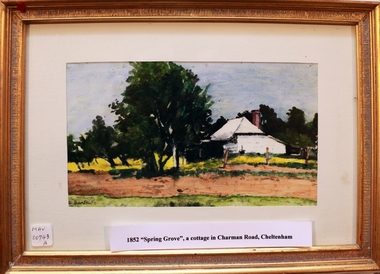
Print - 'Spring Grove' 19thC house, c1979
In 1852 Stephen Charman purchased 160 acres bounded by Charman Rd and Balcombe Road in an area called Spring Grove, later Cheltenham. A spring ran through the land providing a good source of water. Stephen aged 21 years had arrived in Melbourne 1842 as one of Henry Dendy’s emigrants . His Ship passage was paid by the Colonial Land and Emigration Commission and in return he was required to work on the land of the Henry Dendy Special Survey Brighton 1841. However Henry Dendy could not provide enough work for all the emigrants that arrived and Stephen had to obtain other work. Then sadly his young wife Harriett and their infant died. 1850 Stephen married widow Mary Gettens, a Publican in Little Collins Street, with 5 children. Stephen & Mary built a wattle and daub hut and established a market garden producing marigolds for Martin & Pleasance Pharmacists, Melbourne. They had 7 more children and built a weatherboard cottage that was used for early Methodist Church services. Stephen donated 1 acre to the Methodist Church in 1855 for Chapel , School and Cemetery. The picture of the weatherboard cottage was on, a road which runs from Cheltenham to Mentone it bears their name. Charman Road. Mary died in 1870 and Stephen remarried 1878 and died in Gippsland 1906. Stephen and Mary Charman were pioneer settlers in the area of Spring Grove later known as Cheltenham . Charman Road Cheltenham commemorates their contribution to the development of the area. A painting of 'Spring Grove' the home of Stephen Charman and Mary Charman formerly Gettens nee Rees, This cottage was the first house in Charman Road Cheltenham c1852signed L Schumerspring grove cottage 1852, schumer l, cheltenham, charman stephen, early settlers, jones a l, gettens mary, rees mary, charman mary, moorabbin, brighton -
 Stawell Historical Society Inc
Photograph, Pleasant Creek School Students & Some Staff 1866
Staff and Pleasant Creek 502 Common School. Part of a collection of Photographs by Mr. O.G. Armstrong as commissioned by the Shire of Stawell for the Inter-colonial and Paris Exhibition in Melbourne in 1866. The education of children in the early years was at the hands of various denominations and attendance was not compulsory. So it was at Pleasant Creek, where prior to 1858, no real effort had been made by any of the nominations to establish schools. In 1864 the denominational system was abolished and school became known as the ‘common school’, such as pictured. stawell education -
 Stawell Historical Society Inc
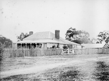
Photograph, "Allanvale" Home Station in Great Western 1866
Allanvale Home Station. Part of a collection of Photographs by Mr. O.G. Armstrong as commissioned by the Shire of Stawell for the Inter-colonial and Paris Exhibition in Melbourne in 1866. Allanvale was taken up about 1841 by John Allen, who was the son of George Allan of Allanvale, near Launceston in Van Diemen's Land. He selected 80,000 acres between present day Stawell and Ararat. The property was gradually reduced in size, with the first split occurring in the 1840s with the annexation of Concongella Selection due to a land dispute. J.S. Davidson was the occupier of Allanvale at the time this photograph was taken. The homestead pictured here was destroyed by fire at the end of the First World War and replaced by a new building around 1923. The present owners of Allanvale are the Kilpatrick family A note on the Allan family. On the 15th of March 1845, John Allen's 26 year old wife died at the birth of their third child, a daughter, who also died several weeks later. Elizabeth Allen had been a dear friend of Mrs Horatio Wills of neighbouring Lexington station. Eliza and her daughter were buried side by side in the garden of Lexington homestead. She was said to have been the first white woman to have died in the district. Homestead and stables on left with people on verandah and orchard in foreground.stawell great western -
 Stawell Historical Society Inc
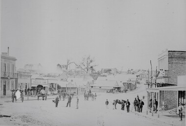
Photograph, Upper Main Street looking East from Patrick Street corner across Layzell Street 1866
Upper Main Street looking East. Poppet Heads in Background. Oriental Bank second on left then Quartz Reef Timber Yards. Intersection is Layzell St Main Street. Advertiser Office on right in front of Earlier Mechanics Institute. Part of a collection of Photographs by Mr. O.G. Armstrong as commissioned by the Shire of Stawell for the Inter-colonial and Paris Exhibition in Melbourne in 1866. View of the top end of Main Street 1866 with the Commercial Hotel in the left foreground. On the right is the Advertiser Newspaper office an Ararat newspaper before one was started in Stawell. The building on the right with the ladder in front was the Mechanics Institute later burned down twice. Upper Main street with Poppet Heads in the background, the Oriental Bank second on left & then Quartz Reef Timber Yard 1867. Lots of people and wagons in street. Advertiser Office on right and earlier Mechanics Institute with ladder at front.Upper Main Street Reefs 1867stawell mining streetscape -
 Stawell Historical Society Inc
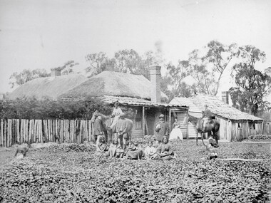
Photograph, Swinton Family Home Station in Glenorchy 1866
Swinton Home Station. Part of a collection of Photographs by Mr. O.G. Armstrong as commissioned by the Shire of Stawell for the Inter-colonial and Paris Exhibition in Melbourne in 1866. Swinton was a family name of John Carfrae, whose father was Thomas Swinton Carfrae of Edinburgh. When John Carfrae came to Ledcourt in 1848 he divided it into three runs, Ledcourt, Swinton and Newington. John Holt occupied Ledcourt and Swindon before 1865, at which time Marcus Clarke was a jackaroo. Alexander Gray came to Swinton in 1881. The Grey family still live at Swinton. The present home was built in 1911 after severe floods in 1909 destroyed the original homestead. Wooden cottage with outbuildings in front of trees. A number of men women and First Nations people standing and sitting in front.stawell aborigional -
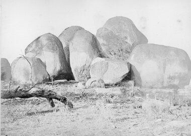 Stawell Historical Society Inc
Photograph, The Sister Rocks Pleasant Creek 1866
The Sister Rocks Pleasant Creek. Part of a collection of Photographs by Mr. O.G. Armstrong as commissioned by the Shire of Stawell for the Inter-colonial and Paris Exhibition in Melbourne in 1866. sailing ship and landed at Port Ferry. They came to Stawell from the port by bullock wagon laden with goods for the goldfield and camped at the Sister Rocks and so they were named. Later the girls married. One became Mrs Hodge and lived on the Western Highway, another became Mrs D’Arcy of the Shamrock Hotel Stawell West. The third was Mrs Moore of Levithan East Stawell. Large Granite boulders with no visible Graffiti. Log on left of photo. stawell tourism