Showing 89799 items
matching dandenong-history
-
 Ballarat Tramway Museum
Document - Manuscript, State Electricity Commission of Victoria (SECV), "Geelong Tramways Early History", 1960s
Consists of formation history, track and route dates, operator, SEC takeover and route lengths. Three pages of statistics - Income, Expenditure and loss 1935 to 1936, - includes car miles., operational statistics, expenditure breakdown of the SEC era. The last three years of operational statistics have been filled in by hand. Probably prepared late 1960's by Les Denmead (assumption here - See Reg item 3289 and 3483 for Bendigo version)Yields historical notes and statistics on the Geelong Tramway system - the statistical information being the most important. Shows the financial situation of the Geelong system was never satisfactory.Four sets - original and three copies - foolscap typed documents, five pages each, titled "Geelong Tramways Early History". 'BTPS 402" in top right hand corner.trams, tramways, geelong, sec, mesco, history, statistics -
 Kiewa Valley Historical Society
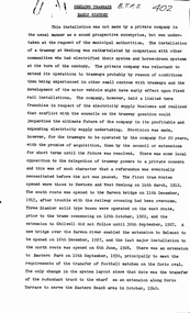
Papers - Mt Beauty High School No.4644, Back to School - Mt Beauty High and Primary School History. See also KVHS 0833
10 points of history pertaining to the History of Schooling in Mt Beauty from 1947 when the SECV and the Education Department erected the school as the population of Mt Beauty grew.A detailed account of the history of schooling at Mt Beauty. Mt Beauty was a construction town run by the SECV when building the KHES.Pink front cover followed by 5 pages of foolscap papers with staple in top right hand corner. Title in black print. In two parts - 1. State School No. 4644 Mount Beauty / Some (10) Points from the School History 2.Mount Beauty High Schoolmt beauty state school, school no. 4644, education -
 Flagstaff Hill Maritime Museum and Village
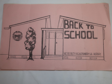
Book - Historical, Warrnambool, Richard Osburne, The History of Warrnambool, 1887
This copy of the book is personally signed and dated by the Curator of the first Warrnambool Museum, which was also the Warrnambool Public Library. This copy also has many hand written notes in the margins. This little book is one of only 1000 books published of the original Queen's Jubilee Edition. It spans fifty years of the history of Warrnambool from the time that the first Government Land Sales commenced. It also deliberately coincides with the 1887 celebrations of Queen Victoria's Jubilee Year of her ascension to the British Throne. The book is an invaluable reference for researchers of local Warrnambool history and has been used as a textbook and reference book for local students. After the closure of the Warrnambool Museum, the book was held by the Warrnambool City Council until, in 1974, it was transferred to the newly established Flagstaff Hill Maritime Museum and Village. The author, Richard Osburne, (1825-1895) was born in Australia. He moved to Warrnambool in 1847 as the first local Journalist. In 1851 he founded the Warrnambool Examiner newspaper which he operated until the end of 1880. Osburne was much involved in civic and community affairs of the town, and he set himself the task of recording the history of the city's early pioneers. In the introductory pages of the book the author refers to himself as "The Father of the Warrnambool Press". Only 1,000 copies of this edition of the book were printed. In September 1980 a facsimile edition was printed with the addition of illustrations from the period, an index and relevant annotations by local historian T.A. Wicking (Tom Wicking). This later book was named the Premier Town Edition, due to Warrnambool being awarded the title of Premier Town in Victoria in 1979-82 by the Premier of Victoria; it also received the inaugural award in 1959 and a later award in 1988-91.This book has strong significance for being signed in 1887 by Joseph Archibald, the Curator of the first museum and library in Warrnambool, the Warrnambool Museum. It is also significant for the annotations added to many of the pages, perhaps for the Facsimile edition that followed many years later. This book is rare. It is one of only 1000 copies printed, and one of three in the Collection of Flagstaff Hill Maritime Museum and Village. The book was dedicated to the early colonists as well as to the new arrivals by the writer, Richard Osburne, who entitles himself as "The father of the Warrnambool Press". The content of the book is invaluable as a reference for Warrnambool and District's local history in its early colonial and pioneering days. It provides the information that helps in an understanding the foundation that the city was built on, connecting the people of today to the pioneers of the past.The History of Warrnambool: Capital of the Western Ports of Victoria, From1847 up to the end of 1886 (when the first Government Land Sales took place) Author: Richard Osburne, "Proprietor of the Warrnambool Examiner from 1851 to the close of 1880" Publisher: The Chronicle Printing and Publishing Company Limited Date: 1887 (MDCCCLXXXVII) (Roman numerals are covered in tape) Edition: Original: Queen's Jubilee Edition Black fabric covered hardcover book with embossed gold titles on spine and front cover. Inscriptions include stamps and handwriting. It once belonged to the Warrnambool Public Museum and is signed by the first Curator, Joseph Archibald, in 1887. The first fly page has a message to the readers, as shown in the Inscriptions of this record. Many of the pages in this book have handwritten notes in the margins and within the text and some of the lines are crossed out.Handwritten: "Warrnambool Museum" Signed: "J Archibald / 1887" Stamped: "WARRNAMBOOL PUBLIC MUSEUM" Printed on fly page: "PRICE, FIVE SHILLINGS" First fly page: "THE QUEEN'S JUBILEE EDITION. TO OLD COLONISTS AND YOUNG AUSTRALIANS, OR NEW ARRIVALS, THIS HISTORY OF THE RISE AND PROGRESS OF THE CAPITAL OF WESTERN VICTORIA, IS DEDICATED AS INTERESTING AND USEFUL, BY "THE FATHER OF THE WARRNAMBOOL PRESS" RICHARD OSBURNE."warrnambool, shipwreck coast, flagstaff hill, maritime museum, maritime village, the history of warrnambool, richard osburne, osturne's history of warrnambool, queen's jubilee edition, 1847-1887, warrnambool history, the chronicle printing and publishing company, capital of the western ports of victoria, first government land sales, warrnambool examiner, five shillings, warrnambool's first reporter, warrnambool public library, 1887, 1979, premier town, premier edition, queen's jubliee, queen victoria's jubilee, western ports of victoria, 1847, government land sales, chronicle publishing and printing co., 1000 copies, t a wicking, old colonists, young australians, new arrivals, rise and progress, capital of western victoria, interesting and useful, the father of the warrnambool press -
 Ringwood and District Historical Society
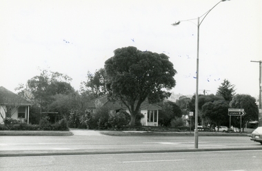
Photograph, Wantirna road, Ringwood, last house on East side before Dandenong Creek on 20th May 1989, 1989
Digital photograph -
 Ringwood and District Historical Society
Photograph, Maroondah Highway. The house at the corner of George Road. Taken from the South side near the junction of Mt Dandenong Road on 10th September 1989, 1989
Digital photograph -
 Ringwood and District Historical Society
Photograph, Maroondah Highway. The house at the corner of George Road. Taken from the South side near the junction of Mt Dandenong Road on 10th September 1989, 1989
Digital photograph -
 Ringwood and District Historical Society
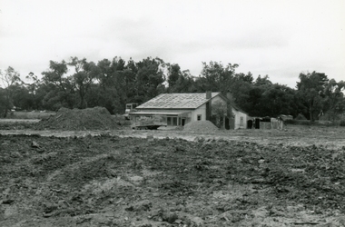
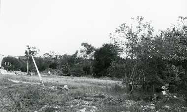
Photograph, East side of Wantirna road between Taurus Restaurant and Dandenong Creek. The land has been raised level with fill, 1989
Digital photographA week after the photo was taken, the house was gone. In the 1950s, the council employed a man with horse and cart to chip and clean the prefabricated gutters. He lived in this house. -
 Ringwood and District Historical Society
Photograph, Ringwood corner Maroondah and Mt Dandenong Road on 10Sep1989. Daisy’s hotel viewed from Georges Road corner
Digital photograph -
 Ringwood and District Historical Society
Photograph, Ringwood corner Maroondah and Mt Dandenong Road on 10Sep1989
Digital photograph -
 Ringwood and District Historical Society
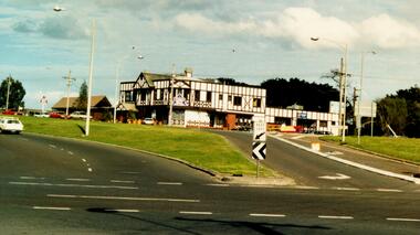
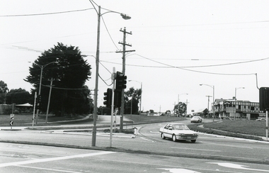
Photograph, New bypass Corner Mount Dandenong Road and Maroondah Highway, Ringwood on 8th November 1992
Digital photograph showing Club Hotel, East Ringwood -
 Ringwood and District Historical Society
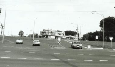
Photograph, New bypass, taken from Corner Mount Dandenong Road and Maroondah Highway, Ringwood on 8th November 1992
Digital photograph -
 Ringwood and District Historical Society
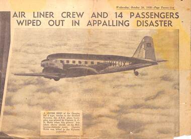
Newspaper - clipping, The Sun News Pictorial, DC2 Kyeema crashed into Mt Dandenong. Crew and 14 passengers killed, 25-Oct-38
The Sun News Pictorial newspaper reports of aircraft disaster. -
 Ringwood and District Historical Society
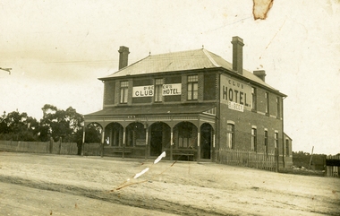
Photograph, Club Hotel, Mount Dandenong Road, (East) Ringwood, Circa 1900
Brick hotel with veranda. Sign above veranda reads "De Beer's Club Hotel" Sign on side of building reads, "Club Hotel - De Beer"(De Beer added to original Club Hotel sign - See item #2819 for earlier photo)Was H006. Photographed by "The Studio of Ringwood" -
 Ringwood and District Historical Society
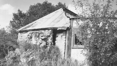
Photograph, Stone Cottage - 1965, probably not 32 Mt Dandenong Rd
Old Stone Cottage with tin roof.Written on backing sheet, "1965 - I don't think this is 32 Mt. Dand." -
 Ringwood and District Historical Society
Photograph, Club Hotel, Mount Dandenong Road, Ringwood East - 1960
Written on back of photographs, "Club Hotel Ringwood East. 1960." "Club Hotel, Mt. Dande Rd. 1960" and "1960 Club Hotel" -
 Ringwood and District Historical Society
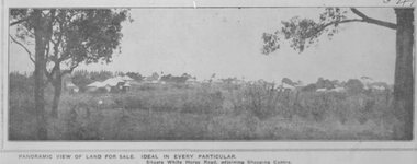
Photograph, Image used for land sale promotion of Pratt's Junction Estate opposite Mount Dandenong Road, Ringwood - 24/11/1923
Catalogue card reads, "Pratt's Junction Estate - 24/11/1923, 86 lots". -
 Ringwood and District Historical Society
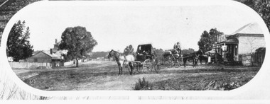
Photograph, Mount Dandenong Road, Ringwood. Blood's store on right, Club Hotel behind tree, Cornell's store on left. c.1900-1910
Written on backing sheet, "Blood's store on right, Club Hotel behind tree, Cornell's store on left". -
 Ringwood and District Historical Society
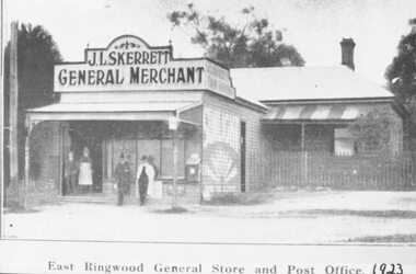
Photograph, Skerrett's Store and Post Office, 1923. Diagonally opposite from Club Hotel in Mount Dandenong Road
Catalogue card reads, "Skerrett's Store and Post Office, 1923. Diagonally opposite from Club Hotel." -
 Ringwood and District Historical Society
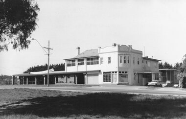
Photograph, Club Hotel, Mount Dandenong Road, East Ringwood in November 1969
Club Hotel, East Ringwood in November 1969Written on backing sheet, "Club 1969. Site originally marked out as local cemetery 1871. Hotel built as single storey 1877" The hotel has a long association with the Reddish family, thus given the name of "Daisy's Hotel". Ryman Healthcare bought the site in 2019, including the garden supply business next door, making up a 2.2ha area. The proposal was for a $220 million retirement village to be built. The location is next to Ringwood Lake with the old hotel being knocked down in the early 2020s. Was H17 in previous numbering system. -
 Ringwood and District Historical Society
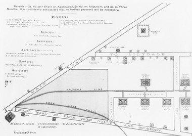
Photograph, Land sale brochure map of Ringwood's early main central area around Mount Dandenong Road - c.1880s
Catalogue card reads, 'Map of Ringwood East'. -
 Ringwood and District Historical Society
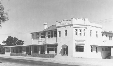
Photograph, Club Hotel, Mount Dandenong Road, East Ringwood in February 1960
Black and white photographs of Club Hotel February 1960 (1 original, three copies). The hotel has a long association with the Reddish family, thus given the name of "Daisy's Hotel". Included 2 copies of the photograph. Ryman Healthcare bought the site in 2019, including the garden supply business next door, making up a 2.2ha area. The proposal was for a $220 million retirement village to be built. The location is next to Ringwood Lake with the old hotel being knocked down in the early 2020s. -
 Ringwood and District Historical Society
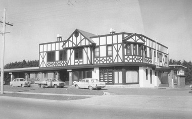
Photograph, Club Hotel, Mount Dandenong Road, Ringwood East 1973
Black and white photographs of Tudor style Club hotel -
 Ringwood and District Historical Society
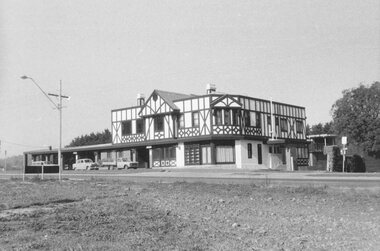
Photograph, Club Hotel, Mount Dandenong Road, Ringwood East in June 1971
Black and white photographs of Tudor style two-storey building (2 originals, 1 copy). The hotel has a long association with the Reddish family, thus given the name of "Daisy's Hotel". Included 2 copies of the photograph. Ryman Healthcare bought the site in 2019, including the garden supply business next door, making up a 2.2ha area. The proposal was for a $220 million retirement village to be built. The location is next to Ringwood Lake with the old hotel being knocked down in the early 2020s. Was H9 in old numbering system.Club Hotel June 1971 -
 Ringwood and District Historical Society
Map - State Aerial Survey, Dandenong Ranges Area, Parishes of Warrandyte and Ringwood - 1956
Map of central and southern areas of Ringwood and part of Ringwood East and Heathmont compiled by Dept of Lands and Survey, July 1956, from aerial photographs and Cadastral Survey information. Subsequent hand-drawn addition of streets showing layout of "Township of Ballyduffy Estate 1858-60", an earlier proposed subdivision that did not eventuate. (See attached 5009b Ballyshanassy_ Melbourne’s lost suburb.pdf for Ballyduffy historical naming relevance). Ballyduffy Estate streets include City Road, West Prussia Road, Duffy Street, Ireland Street, Evans Street, Victoria Street, Regina Street, Short Road, Prussia Road, Duffy Street East, Ireland Street East, Evans Street East, Chapman Street. Misc Topo 93 Sheet 22, Ringwood A4B2. Scale: 4 chains to 1 inch. Contour interval 20 feet. -
 Ringwood and District Historical Society
Map - State Aerial Survey, Dandenong Ranges Area, Parts of Parishes of Nunawading, Warrandyte and Ringwood - 1956
Map of Ringwood North and parts of Mitcham, Donvale, Park Orchards and Ringwood East compiled by Dept of Lands and Survey, July 1956, from aerial photographs and Cadastral Survey information. Sheet 1, Ringwood A2D or 849 A2D Zone 7. Scale: 4 chains to 1 inch. Contour interval 20 feet. -
 Ringwood and District Historical Society
Map - State Aerial Survey, Dandenong Ranges Area Sheet 7, Parishes of Warrandyte, Scoresby, Ringwood and Nunawading - 1956
Map of central and southern areas of Ringwood and part of Ringwood East and Heathmont compiled by Dept of Lands and Survey, July 1956, from aerial photographs and Cadastral Survey information. Subsequent coloured hand-drawn additions showing layout of a number of post-NSW Separation era proposed subdivisions that did not eventuate, including Village of Studley Estate, Township of East Kew Estate, Township of Ballyduffy Estate, Township of New Flemington Estate, Township of East Hawthorne Estate. Ringwood A4B2, 849 A4B Zone 7. Scale: 10 chains to 1 inch. Contour interval 20 feet. -
 Ringwood and District Historical Society
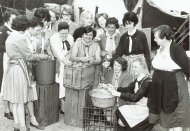
Photograph, Ida Oke and all at Dandenong Scouting Jamboree in 1965
Scanned on 30th January, 2008 from Ida Oke's albums. Ida lives in East Ringwood and also contributed to the East Ringwood Recollections book. Wife of Bob (Robert William) Oke. Both Ida and Bob were heavily involved in the Scout movement, as were Bob's parents - Corrie and Ruby (Guides) Oke, who both lived in Old Lilydale Road, East Ringwood. -
 Ringwood and District Historical Society
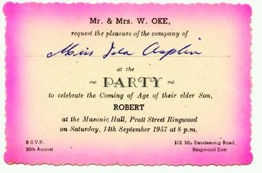
Photograph, Invitation from Mr and Mrs W Oke (101 Mt Dandenong Road, East Ringwood) to celebrate son Robert ("Bob") on his 21st at Ringwood Masonic Hall, Pratt St, Ringwood 1957
Scanned on 30th January, 2008 from Ida Oke's albums. Ida lives in East Ringwood and also contributed to the East Ringwood Recollections book. Wife of Bob (Robert William) Oke. Both Ida and Bob were heavily involved in the Scout movement, as were Bob's parents - Corrie and Ruby (Guides) Oke, who both lived in Old Lilydale Road, East Ringwood. -
 Victorian Aboriginal Corporation for Languages
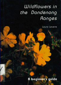
Book, Laura Levens, Wildflowers in the Dandenong Ranges : a beginner's guide, 1997
Small format book. Chapters organised according the colour of the flowers.Colour photographs, glossarywildflowers, plants, dandenong ranges -
 Whitehorse Historical Society Inc.
Map, Dandenong Ranges Area, 1956
Sheet 1. Parts of Parishes: Nunawading, Warrandyte and Ringwood. Scale: 10 chains : 1 inch. Contour intervals marked and locations of buildings.Sheet 1. Parts of Parishes: Nunawading, Warrandyte and Ringwood. Scale: 10 chains : 1 inch. Contour intervals marked and locations of buildings. Compiled from aerial photographs and cadastral survey information.Sheet 1. Parts of Parishes: Nunawading, Warrandyte and Ringwood. Scale: 10 chains : 1 inch. Contour intervals marked and locations of buildings. maps, ringwood, mitcham, warrandyte