Showing 1147 items
matching decision
-
 Glen Eira Historical Society
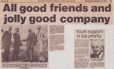
Photograph - Mayor Jack Campbell 1986-87 (1 of 2)
Newspaper articles relating to activities in Caulfield involving Mayor Jack Campbell as well as photograph of Cr Jack Campbell in the Mayoral robes 1). Short article and photograph of Malvern and Caulfield council celebrating decision not to merge councils 2). Article on Youth Support as a key item as Mayor 3). Article on Arts Centre and criticism from Cr Don Dunstan 4). Photograph of Cr Jack Campbell in Mayoral robes 5). Article on Elsternwick Post Office demolition Article on the proposed new Arts Centre 6). Media ban on councillors 7). Maysbury Avenue Houses reportcouncillor, mayor, jack campbell, peter birrell, ray lang, doug aylen, don dunstan, elsternwick post office, glen huntly rd, veronika martens, betty snowball, walter kay, lewis sayer, david bloom, arts centre, carol harry, jack ritchie, inkerman rd, geoff leigh, malvern council, maysbury ave, glen huntly rd, supermarket, consulere pty ltd -
 Federation University Historical Collection
Magazine - Booklet, Baxter & Stubbs, Print, Ballarat School of Mines Students' Magazine, 1923, 1923
Editorial, In Memoriam: Robert James Dowling, Fumes from the Lab, A trip to America, Arts & Crafts Gossip, Echoes of the Past, Sport, The Junior Techs. Under Arts & Crafts Gossip the writer gives on overview on 'modern books on fine art'. "... In making this decision as to whether his tone values are correct or not the artist always studies his canvas from a distance of several yards. An excellent system of painting is being practised and taught by Max Meldrum. This consists of painting in the orders of the impressions. This method is fully explained in his book, and will be found invaluable by the student desiring to work on sound lines. ...Brown soft covered magazine..1) Stamped "Ballarat Technical Art School" .2) Written on front cover "Hessie Darby"ballarat school of mines, magazine, hessie darby, ballarat technical art school, e. kift, ethel kift, r. t. crosthwaite, c. mcilvena, h. finlayson, e. mckissock, f. russell, c. s. hunt, j. r. pound, a. leask, m. timmings, professor alfred mica smith, robert james dowling, e. j. mcconnon, r. g. cox, edwin a. brophy, raymond fricke, nancy humphries, r. sage, max meldrum -
Unions Ballarat
Sir John did his duty (Don Woodward Collection), Barwick, Garfield, 1983
The Whitlam ALP government came to power in 1972 after 23 years in opposition. Whitlam's government was aspirational in terms of its social justice and equality agenda. The government was dismissed on 11 November 1975 by the governor general, Sir John Kerr; this act was unprecedented. The book is written by Garfield Barwick who was a high court judge; Barwick provided advice to Sir John Kerr at the time. The author defends the appropriateness/legality of Kerr's role and decision making at the time of the dismissal. The ALP lost the election held on 13 December that was caused by the 1975 double dissolution/constitutional crisis.Relevance to Australian political and constitutional history. Book; 129 pages. Front cover: white background; green illustration of a building; green lettering; author's name and title.Price - 50c - in pencil.btlc, ballarat trades and labour council, ballarat trades hall, politics and government, constitution - australia, kerr, sir john, barwick, garfield, whitlam, gough, prime ministers - australia - gough whitlam, prime ministers - australia - malcolm fraser, fraser, malcolm, dismissal - government, courts - high court, parliament, australian labor party, alp, liberal party australia -
 Vision Australia
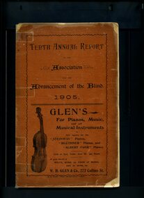
Administrative record - Text, Tenth Annual Report of the Association for the Advancement of the Blind 1905, 1905
Annual report of the Association for the Advancement of the Blind outlined activities and events over the year, including membership of 166, the death of B.W. Holgate who was a most active worker, another order of goods has arrived from England, due to the large increase of work an office has been opened at Oxford Chambers, the Tea Agency has been reorganised, decision to establish an Australian Braille Correspondence club, asking for help in identifying anyone needing the services of the Association and efforts being made to remove the Immigration Restriction Act thus removing the bond required when travelling between states.1 volume of printed material with some illustrationsassociation for the advancement of the blind, annual reports -
 Ballarat and District Irish Association
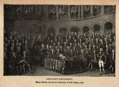
Image, Gratton's Parliament, 1782
Calls for the legislative independence of Ireland at the Irish Volunteer Convention at Dungannon greatly influenced the decision of the government in 1782 to make concessions. It was through ranks of Volunteers drawn up outside the parliament house in Dublin that Grattan passed on 16 April 1782, amidst unparalleled popular enthusiasm, to move a declaration of the independence of the Irish parliament. "I found Ireland on her knees," Grattan exclaimed, "I watched over her with a paternal solicitude; I have traced her progress from injuries to arms, and from arms to liberty. Spirit of Swift, spirit of Molyneux, your genius has prevailed! Ireland is now a nation!" After a month of negotiation the claims of Ireland were conceded. The gratitude of his countrymen to Grattan was shown by a parliamentary grant of £100,000, which had to be reduced by half before he would accept it. Grattan then asked for the British House of Commons to reconfirm the London government's decision, and on 22 January 1783 the final Act was passed by parliament in London, including the text: Be it enacted that the right claimed by the people of Ireland to be bound only by laws enacted by his Majesty and the Parliament of that kingdom, in all cases whatever shall be, and is hereby declared to be established and ascertained for ever, and shall at no time be questioned or questionable. In September of the same year, Grattan became a member of the Privy Council of Ireland. He was expelled in 1798, but was re-admitted on 9 August 1806. [http://en.wikipedia.org/wiki/Henry_Grattan, accessed 14/12/2014]An image of a number of men in Parliament. It is Henry Gratton's Parliament. The man standing is Henry Gratton moving the declaration of Irish Rights in 1782.ballarat irish, henry grattan, grattan, irish rights -
 Bendigo Historical Society Inc.
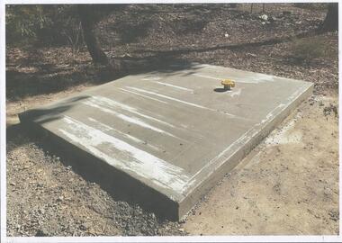
Photograph - Kangaroo Flat Gold Mine Collection: Catherine Reef South shaft
Kralcopic Pty Ltd, was a subsidiary of Bendigo-based company GBM Gold and had previously held mining licences around Bendigo, which incorporated sites including Kangaroo Flat, New Moon, Eaglehawk and the associated Woodvale Evaporation Ponds Complex. In August 2019, the Earth Resources Regulator decided not to renew Kralcopic’s three mining licences, due to the company’s inability to provide surety that it could finance its mining activities and site rehabilitation obligations. In October 2020, the company filed legal proceedings in the Supreme Court challenging the decision not to renew these licences. The Supreme Court later upheld the regulator’s decision not to renew the licences. On 23 April 2021, the Federal Court of Australia appointed KPMG as Kralcopic’s liquidators. On 14 May 2021, the liquidator lodged papers with the Australian Securities and Investment Commission (ASIC) to disclaim Kralcopic’s freehold land at Woodvale and parcels of land around the company’s former Bendigo sites, with the land to subsequently become Crown land. The Earth Resources Regulator has put a statutory exemption in place to preclude new mining licence applications on the sites while we undertake rehabilitation. The exemption also provides an opportunity for government to consider future uses of the sites in consultation with the City of Greater Bendigo and the local community. The Earth Resources Regulator holds rehabilitation bonds totalling $5.9 million, which it will use to rehabilitate the former sites.Colour photocopy of original photo. Image shows Catherine Reef South shaft with rectangular concrete capping. Ventilation pipe in concrete capping. On back in pencil: Catherine Reef South shaft with cap - Kralcopicwestern mining corporation, goldmining, capping, shaft, mining regulations, williams united shaft, kralcopic -
 Kiewa Valley Historical Society
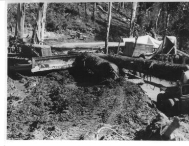
Photograph, logging at McKay Creek, Logging at McKay Creek, c1950's
This photograph was probably taken at the site of McKay Creek Power Station. Excavation of this site did not commence until 1951 but road access(a narrow track) was provided in 1948 and widened in 1954. The logs would have been milled for timber at the State Electricity Commission's mill at Howman's Gap and thus provided a much needed source of timber for construction of camps and houses as there was a general of shortage of this commodity. Because of trouble with landslides in this area, a decision was made to place the machine hall of the power station underground instead of on the surface. Restricted financial resources and the repositioning of the power station retarded construction activities and it was not completed until early 1961.. An excellent pictorial record of the general working conditions, type of machinery and vehicles in use in the 1950/s.Black and white photograph showing logging equipment, fallen logs.Handwritten on the back of the photograph "Logging at McKay Creek)logging, mckay creek, timber, machinery -
 Bendigo Military Museum
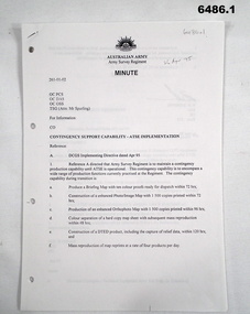
Document - Contingency Support Capability - Army Topographic Support Establishment (ATSE) Implementation, Army Survey Regiment, Bendigo, Apr - Jun 1995
.1 The Minute details that the Army Survey Regiment is maintain a contingency production capability until ATSE is operational. .2 The Minute details the Data Aquisition Squadron requirements during the Implementation to ATSE. .3 The Minute details the Hardware, Software, Personnel and skills required during Implementation to ATSE. .4 The Instruction details that the non-core mapping, charting and geodetic (MC&G) activities of the Army Survey Regiment and 4 Fd Svy Sqn were tested under the Commercial Support Program (CSP) process resulting in the decision to award the contract for the provision of non-core mapping services to the ADF to the Preferred In-House Option (PIHO). .1 Contingency Support Capability - Army Topographic Support Establishment (ATSE) Implementation 26 Apr 95 (11 x A4 pages) .2 Data Acquisition Squadron (DAS) Contingency Support Capability - Army Topographic Support Establishment (ATSE) Implementation Apr 95 (4 x A4 Pages) .3 Contingency Support Capability - Army Topographic Support Establishment (ATSE) Implementation 28 Apr 95 (9 x A4 pages) .4 Directorate of Military Survey - Army Instruction for Implementation of the Army Topographic Support Establishment (ATSE) Jun 95 (10 x A4 pages)royal australian survey corps, rasvy, fortuna, army survey regiment, army svy regt, asr, atse -
Vision Australia
Audio - Sound recording, Letter to clients regarding the Vision Australia Awards, 2005
The Braille Book of the Year awards were first established by the Braille and Talking Book Library in 1974, as a way of recognising excellence in Braille production. In 1990 the first Narrator of the Year was awarded, then followed by the Audio Book of the Year in 1991. With the merger with the AFB, then the name change to Vision Australia Foundation, these awards were rechristened the Vision Australia Foundation awards. In 2005, another merger took place and the decision was made to only continue the original award, due to both limited funds and the development of the commercial audio book industry and thus commercial audio awards. This letter was sent to members to advise of the changes and the reasons behind it.1 CD with 1 sound filevision australia, awards -
Glen Eira Historical Society
Document - Leuba, Cecile
Three items about Cecile Leuba and her family. Photocopied article taken from ‘From Jolimont to Yering-Yarra wine- Two Centuries’ by Raymond Henderson 2006. The article mentions Sam and Cecile Leuba, and their return to Melbourne from Switzerland and their subsequent decision to rent accommodation at “Aldgate”, Caulfield, 1914 to 1920. Photocopied article, death notice for Bert Parkinson, inserted by Florence Leuba ‘of Aldgate’ Kooyong Road, Caulfield, dated 1917. Hand written research by Claire Barton 23/03/2013, from (a) book ‘From Jolimont to Yering-Yarra Wine- Two centuries’ and (b) Argus newspaper circa 05/05/1917.leuba sam, leuba cecile, pioneers, leuba emma, hebenstrait hans, ‘aldgate’, caulfield, house names, kooyong road, leuba florence, luba madeline, lueba berthe, leuba anna, parkinson bert, parkinson albert e -
Glen Eira Historical Society
Document - Ormond Amateur Football Club
This file contains 2 items: 1/An article from the website of the Southern Metro Junior Football League, dated 04/04/2014, forwarded to Ormond Amateur Football Club, about Max Gawn, former Auskick and amateur club player, on his decision to coach at his junior club, U16 team, whilst working around his AFL obligations as a senior player. 2/An article from the Caulfield/Glen Eira Leader, dated 08/04/2014, on the return of number one ticket holder Bob Skilton to Ormond Football Club after having surgery. Also mentions Ormond’s return to Premier C grading.southern metro junior football league, gawn max, mccooke alistair, ormond, lovett craig, mclaren greg, coaches, auskick, ormond football club, brownlaw medallist, sporting clubs, clubs and associations, australian rules football, skilton bobby, e. e. gunn reserve, buckley tom -
Port Melbourne Historical & Preservation Society
Plant specimen - Branch, Port Jackson fig tree, Holy Trinity Anglican Church, Dec 1999
The tree was chopped down December 1999 in spite of local opposition, to make way for a planned development of the church hall. The application was refused by Port Phillip Council but approved by VCAT in a contentious decision. There was conflicting advice about the health of this tree which at that time enjoyed no protection under the planning scheme. Local landscape architect, Ray PICKFORD, landscape architect and owner (at that time) of Morley's house at cnr Farrell and Nott St, was so distressed by this action that he stripped in an attempt to generate media attention. Subsequently, ward councillor Julian HILL purchased a portion of the timber from a wood recycler and it was re-made into timber benches for the refurbished Port Melbourne Library.Portion of branch from Port Jackson fig located in the grounds of the Holy Trintiy Church Hall, demolished December 1999 (Ref 1421)religion - anglican (holy trinity), built environment, demolitions -
 City of Ballarat
Artwork, other - Public Artwork, Ratartat, Crossing Rubicon, 2008
“This public art project honours the people and suburb of Sebastopol, as well as providing a strong visual identity for Albert Street. It will make the street a lot more attractive and welcoming. The project is the outcome of extensive consultation with groups and individuals in the Sebastopol community, who have made suggestions both as to the nature of the project but also the aspects of life in their community they wanted to represent through the artwork.”Crossing Rubicon by Ratartat is located in Albert Street, Sebastopol, Ballarat. A row of 16 lampposts in Sebastopol’s main street are topped with large enamelled steel sculptures of trees, representing different aspects of Sebastopol’s community life and history. Ratartat is an artistic collaboration of Ballarat-based artists Geoff Bonney and Pete Widmer. The name, Crossing Rubicon, refers to Rubicon Street, the boundary between Redan and Sebastopol. The street was named after the Rubicon River, an ancient boundary between Italy and Gaul. Julius Caesar’s decision to cross the river, thereby rebelling against the Roman Senate, gave rise to the expression “crossing the Rubicon”, meaning going past the point of no return.Sixteen powder-coated steel sculptures mounted on light polesrubicon, sebastopol, ratartat -
 Vision Australia
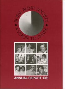
Administrative record - Text, Royal Blind Society of N.S.W. : A Vision to Share Annual Report 1981, 1981
Articles in the annual report include: establishment of the Charter for the Eighties committee to develop on the role and direction for the organisation, decision to close Alexis Albert Hostel and move residents to Lighthouse Hostel Roselands or cottage style accommodation due to increasing repair costs, increased demand for field service (but not funding) and standard cassettes from the library, new Braille production unit shared with RIDBC, further bicycle order for Dubbo Zoo, large order for PVC sleeves justified new PVC welding equipment, Talking Book of the Year award and "Art in Touch" exhibition (both created to celebrate 100th birthday in 1980) will continue, and departure of Graeme Bradshaw, Jack Chamberlain and Mavis Threlfo.1 volume of text and imagesroyal blind society of new south wales, corporation records -
 Wodonga & District Historical Society Inc
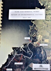
Booklet - Hume Dam Remedial Works - Review of Environmental Factors July 1995, Department of Land and Water Conservation, NSW Government, July 1995
The findings of a review into the environmental impact of remedial works being carried out on the Hume Dam.non-fictionThe findings of a review into the environmental impact of remedial works being carried out on the Hume Dam.hume dam, remedial works dams, environmental impact of dams -
 Wangaratta RSL Sub Branch
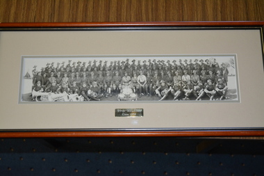
Photograph - Framed photograph
The 59th Battalion was an infantry battalion of the Australian Army. Initially raised for service during World War I, the battalion fought on the Western Front in France and Belgium between 1916 and 1918, before being disbanded in 1919. In 1921, it was re-raised as a part-time unit of the Militia in Victoria. They remained in existence until 1942 when, due to a manpower shortage in the Australian economy, the decision was made to amalgamate the battalion with the 58th Battalion to form the 58th/59th Battalion. Together they remained linked throughout World War II, serving in New Guinea and Bougainville in 1943–1945. In 1952, the 59th Battalion was re-raised and subsequently was absorbed into the Royal Victoria Regiment in 1960.Brown timber frame containing cream coloured mount and photograph of large group of soldiers and bandsmenPlaque -59th Militia Circa 193959th militia, ww1, ww2, 1939 -
 Eltham District Historical Society Inc
Document - Property Binder, 813 Main Road, Eltham
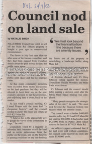
Newspaper article: Council nod on land sale, Diamond Valley Leader, 24 July 2002, Nillumbik Council voted to sell this land. Newspaper article: Grapple on Gateway, Diamond Valley Leader, 11 September 2002, photograph of demonstrators against development of land. Newspaper article: Prominent site protected, Diamond Valley Leader, 6 December 2006, Victorian Civil and Administrative Tribunal upheld decision to refuse development permit, action by Eltham Gateway Action Group. Newspaper article: Daniel's a tree fella, Diamond Valley Leader, 24 July 2002, Daniel Jarvis involved in Planet Ark's National Tree Planing Day, Friends of Falkiner Street Reserve.main road, eltham, property, eltham gateway action group, daniel jarvis, friends of falkiner street reserve. -
 Kiewa Valley Historical Society
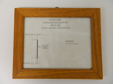
Sketch Rock Core Display, circa mid to late 1900's
This framed sketch details, in graphic form, where the core samples in the display cabinet were removed. The drilling was a precursor to the decision where to locate, in this case, the McKay Creek Power Station. The information gained by structural engineers from the core samples would be used also for the placements of underground tunnels entry and exit points and the overall effective size of the plant. This would have included drill and blast techniques(rock characteristics play an import part of explosion control), requirements for support structures and reinforcing cement/steel forms. The use and replenishment of diamond drill bits(the strongest available, see KVHS 0280) was dependent on the "type" of rock found. Support beams for reinforced ceilings and floors was also a necessity.The visual derails of where the rock core samples were removed is very significant in the formulation and placement of the underground Power Stations and their maze of tunnels(in and out) for a successful implementation of the Hydro Scheme. The amount of pre-planning and scientific studies required for such a large scheme must be undertaken to ensure that a "white elephant" was not the result.This framed and glass front rock core display sketch has type written information of the rock samples displayed in KVHS 0279 (A). It has a softwood stained and glossed frame with a fixed(nailed) back board and a brass fixture for mounting onto a wall.The paper and type are slighted faded (sunlight affected). The sign heading "ROCK CORE SAMPLES RECOVERED FROM DIAMOND DRILLED BORE" underneath this "BORE NO: 883" and below this "LOCATION: McKAY CREEK POWER STATION AREA" to the left a sketch incorporating the ground level point "GROUND LEVEL R.L.3493", and the core depth point "CORE DEPTH 40' 7". In between and representing( in visual form) the core location areain question.alternate energy supplies, alpine feasibility studies temperature, rainfall, sec, kiewa hydro scheme, electricity -
 Uniting Church Archives - Synod of Victoria
Photograph, undated
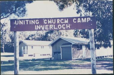
The photograph is from the Brian Walsh Collection 1993. Three blocks of land were purchased in 1946 by Miss F. Ritchie and Mrs H. Grimshaw in Halford St. Inverloch. Three more blocks were purchased in 1948 - 1949. A sixth block was added in 1956. Money was raised by P.F.A. members. Two buildings were purchased from the Government Disposals Authority in 1959. Construction of the camp began in October 1959. Regular working bees were held by P.F.A. members. The first camp was held at the site at Easter 1960. The camp was opened by the Moderator the Rt. Rev. A. Creighton Barr and Flinders Presbytery ministers. In 1998 the decision was taken to sell the site. No buyer was recorded by April 2000.Colour photograph mounted on card showing the exteriors of two camp dormitories in bushland.Uniting Church Camp Inverloch. Gippsland Presbytery. Brian Walsh Collection 1993presbyterian church camp, inverloch, flinders presbytery, p.f.a., miss f. ritchie, mrs. h. grimshaw, rt. rev. creighton barr -
 Vision Australia
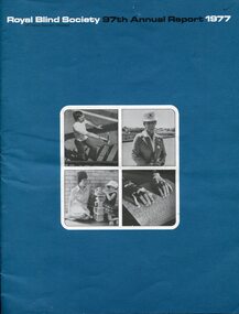
Administrative record - Text, 97th Annual Report Royal Blind Society of N.S.W. (1977), 1977
Articles in the annual report include: increased funding from state government, possibility of sustained funding in providing a public library service, success of low vision clinic and need to increase opening times to accommodate demand, decision to move to standard cassette, change in direction by providing support for children to stay in family unit and community kindergartens rather than placement in a separate kindergarten program or residential care, introduction of Closed Circuit TVs into the workshop, winning a 2 year contract with Australia Post to provide bicycles and an order from Dubbo Zoo for family cycles and tandems, formation of RPH with a trial broadcast and radio license application made, and the Society held it's first Open Day.1 volume of text and imagesroyal blind society of new south wales, corporation records -
 Vision Australia
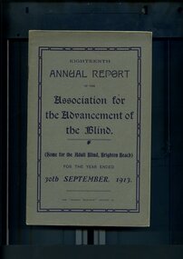
Administrative record - Text, Eighteenth Annual Report of the Association for the Advancement of the Blind 1913, 1913
Annual report of the Association for the Advancement of the Blind outlined activities and events over the year, including the inception of a series of conferences attended by representatives of various interstate and local blindness agencies, as part of an exchange of ideas with a deputation to Federal Ministers and the Premier of Victoria being favourably received, decision to form a regular concert party due to successful endeavours over the past two years, the issue of postal rates for Braille will be brought under notice at the next Postal Conference with the hope that change will eventuate in this area, a Memorial Fund has been established to perpetuate the memory of May D Harrison with a tablet placed in the Braille Library and a marble cross erected on her grave, and an obituary for W H Campbell, former President..1 volume of printed material with some illustrationsassociation for the advancement of the blind, annual reports -
 Falls Creek Historical Society
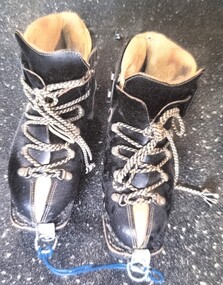
Equipment - Kastinger Boots 1950s
Kastinger Boots Founded by Hermann Kastinger, the company was based in Austria from 1909 to 1981 . After several bankruptcies and changes of ownership, the company Lemipan , based in Pirmasens , Germany , is the current licensee. In 1932, Max Kastinger took over the business from his father. In addition to double-stitched shoes, glued models were also produced for the first time. The decision to use this design laid the foundation for the inexpensive mass production of winter shoes. In 1953 the first successes were also achieved outside of Austria. Sales of the boots took off internationally and were greatly adapted and improved as ski technology also evolved. In 2009, the Kastinger brand celebrated its 100th anniversary. This image is significant because it documents changes in the design of ski boots over time.A pair of black leather lace-up boots with a white leather trim.Kastinger logo on outside of bootsski boots, kastinger boots, ski equipment 1950s -
 Kew Historical Society Inc
Plan - Subdivision Plan, J R Mathers & McMillan, Glenarbor Estate, 1934
Pru Sanderson, in her groundbreaking ‘City of Kew Urban Conservation Study : Volume 2 - Development History’ (1988), summarised the periods of urban development and subdivisions of land in Kew. The periods that she identified included 1845-1880, 1880-1893, 1893-1921, 1921-1933, 1933-1943, and Post-War Development. These periods were selected as they represented periods of rapid growth or decline in urban development. An obvious starting point for Sanderson’s groupings involved population growth and the associated economic cycles. These cycles also highlighted urban expansion onto land that was predominantly rural, although in other cases it represented the decline and breakup of large estates. A number of the plans in the Kew Historical Society’s collection can also be found in other collections, such as those of the State Library of Victoria and the Boroondara Library Service. A number are however unique to the collection.The Kew Historical Society collection includes almost 100 subdivision plans pertaining to suburbs of the City of Melbourne. Most of these are of Kew, Kew East or Studley Park, although a smaller number are plans of Camberwell, Deepdene, Balwyn and Hawthorn. It is believed that the majority of the plans were gifted to the Society by persons connected with the real estate firm - J. R. Mathers and McMillan, 136 Cotham Road, Kew. The Plans in the collection are rarely in pristine form, being working plans on which the agent would write notes and record lots sold and the prices of these. The subdivision plans are historically significant examples of the growth of urban Melbourne from the beginning of the 20th Century up until the 1980s. A number of the plans are double-sided and often include a photograph on the reverse. A number of the latter are by noted photographers such as J.E. Barnes.The little-known Glenarbor Estate comprised 23 allotments bordering Wellington and Denmark Streets and Fenton Avenue. The auction of the allotments in the Estate was held in the Kew Recreation Hall. The purported advantages to Kew are identified on the plan, such as the close proximity of the entrance to the Kew Railway Station and access to shops in Denmark Street. Due to its location, the subdivision was pitched at commercial as well as residential purchasers. The Estate was to cause a crisis in the Kew Council as a majority of councillors voted on 29 May to acquire the entire Estate as the location of a new Town Hall. The Estate was said to be valued at £50,000. A later meeting was to rescind the vote, instead opting for the compulsory acquisition of South Esk on the corner of Charles Street and Cotham Road. That acquisition was to be overturned by the State Government. The debate about the purchase of the Glenarbor Estate by Council coincided with the decision to widen High Street on the South side between Cotham Road and the Junction."D"subdivision plans - kew, glenarbor estate, wellington street, denmark street -
 Melbourne Tram Museum
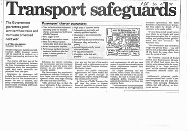
Pamphlet, Minister of Transport, "Transport Safeguards", "New Guarantees for Public Transport Passengers effective mid 1999", "A New Partnership - Reforming Victoria's trains and trams: what it means for public transport employees", 1998 - 1999
Set of three items related to the decision to franchise the public transport in Melbourne during late 1998. Items are related to Reg Item 2830. a report titled "A system into a Service" by the Victorian Government late 1998. .1 - photocopy of a newspaper article in The Age 30/10/1998 titled "Transport Safeguards" written by Lyall Johnson giving details of the Passenger Charter, guarantees, quotes Robin Cooper, Minister for Transport. Has a cartoon by Tandberg. .2 - Pamphlet - 4 fold DL titled "New Guarantees for Public Transport Passengers effective mid 1999" detailing the Passenger charter. .3 - Pamphlet - 3 fold DL titled "A New Partnership - Reforming Victoria's trains and trams: what it means for public transport employees", outlining the corporate structure, franchising and private ownership, guarantees for employees and passengers. Not dated.trams, tramways, public transport, franchising, ptc, privatisation, passengers, minister for transport, cartoons, passenger services -
 Ballarat Tramway Museum
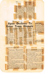
Newspaper, State Electricity Commission of Victoria (SEC) and The Courier Ballarat, Apex declines to enter tram dispute, Mar. 1962
Yields information about the views of various letter writers, special trains for the Begonia Festival and issues re costs.Foolscap sheet of plain paper, with rounded corners, with 5 newspaper cuttings, concerning the mooted closure of the Ballarat Tram system 28 Feb and 2 March 1962. All from The Courier, unless noted otherwise. 1 - "Trams in 1886" - 28-2-62 - about the formation of the Ballarat Tramway Co. 2 - "Keep Trams" - 28-2-62 - about the lack of trams for church and public service 3 - "Apex Declines to Enter Tram Dispute" - 1-3-62 - determined not to support the Union to support the trams 4 - "Track Times" - 1-3-62 - letter about the speed of the tram service, slow, notes a Mr. Mawby comment. 6 - "Tramway Discussions" - 2-3-62 - Editorial commenting on the APEX decision, Union request, service clubs, becoming a political issue, community support for the trams.closure, letter to the editor, editorial, sec, apex -
 Kiewa Valley Historical Society
Vaporiser Cresolene, circa late1800's to early 1900's
This Cresolene vapouriser is an "American" product when "home" based remedial products were of a high demand due to lack of specialised medical facilities such as a hospital in rural communities. "An apparatus for reducing medicated liquids to a state of vapor suitable for inhalation or application to accessible mucous membrane A device for volatising liquid anesthetics." The only criteria used by Health authorities in the decision to provide a community with hospitals was and still is the size of the population it feeds. The introduction of the SEC Victorian Hydro Electricity Scheme started in the 1940's, was the impetus for health planners to build a hospital in the Kiewa Valley. Rural regions especially those considered semi or fully remote locations had to rely on farm based remedial health "alternative medical treatment". This product is such a remedy.This vapouriser is very significant to a rural area such as the Kiewa Valley as it demonstrates the "home" remedies that were available to rural communities such as the cattle and sheep stations before the Kiewa Valley had a hospital(1949). The influx of workers employed by the SEC Vic. Hydro Electricity Scheme(circa 1940's onward) changed dramatically the need for a hospital and specialised medical treatment. The reliance of "health products" such as this vaporiser were still in high demand especially when on the box of this product was printed "Guaranteed under the Food and Drugs Act, June 30, 1906, Serial no. 436". Also on the packaging is printed "A remedy Whooping Cough also Asthma, Catarrh, Colds Diptheria, Croup, Coughs Hay Fever, Sore Throat, Influenza, Etc." An additional benefit of this product "Is obnoxious to Moths, Flies, Mosquitos, Ants, Cock Roaches, Hen Lice, and other Troublesome insects." This advertising is dated before a tightening in the "advertising" legislation of post mid 1900's. However it was a good attraction for rural communities wanting relief of "rural" pests. This vaporiser stand with its cradle and dish is made from cast iron (stand) and tin (dish). At the bottom of the "dish" is a flame diffusion port with eight heat directional holes. The stand upright is painted gold in colour.See KVHS 0342 (B) for markings and advertising material printed on the box which contains this item.home based vaporisers, first aid, home nursing, over-the-counter medicines -
Stawell Historical Society Inc
Trophy - Perpetual, Engraved Two handled Chalice
The Mouth Organ Band held another compition at the band room on Monday evening. Various sections were well contested and the decisions of th eadjudicator - Mr Jack Holloway - gave every satisfaction. Prizes were awarded as follow: "A" Grade - N. Haywood, 49 Points 1: W. Reeve, 47 Points 2; C. Oliver 32, 3. "B" Grade - R. Pickering 1. "C" Grade - S. Pickering 1. The Medal for the "C" Grade winner was donated by the ladies' commiteetee, and the "a" and "B" Grade prixzes were from th eVictorian Mouth Organ Association with which body teh Stawell Band is affiliated. Stawell News & Pleasent Creek Chonicle 07 Feb 1934.Plastic/ Bakerlite with Metal Chalice ornate lipS M.O.B Solo Contest 'B Grade' Presnted by V.M.D.B.A Won By A Pickering 5.2.34band, musical instrument -
 Vision Australia
Administrative record - Text, RVIB Ocean Grove Auxiliary, 1944-2005
The Ocean Grove RVIB Auxiliary formed on July 31, 1944. This collection of papers includes the minute books from 1944 until 2002 and printed minutes from 2002 to the conclusion of the Auxiliiary in 2004. The papers include newspaper clippings, correspondence, secretary and annual reports, 1999-2005 syllabus (list of events), lists of office bearers and balance sheets. A signboard for the Auxiliary's kiosk in 1951, a poem from the last President Dot Whitehead and the acknowledgement letter from RVIB regarding the Auxiliary's final donation and decision to conclude are also here. The index cards were maintained by RVIB and contain the amount of donations made by the Auxiliary between 1976-1995, as well as the presentations delivered by RVIB employees to Auxiliary meetings between 1973-1985.6 minute books -- 1 receipts book -- 2 index cards -- various loose papers -- signboard -- receipts & expenditure book -- certificate.royal victorian institute for the blind, auxiliaries, ocean grove -
 Eltham District Historical Society Inc
Audio - Audio Recording, Jim Connor - From Eltham to Nillumbik Shires and subsequent development proposals of the former Eltham Shire Office site - a personal perspective, 2 Jun. 2024
Guest speaker at Eltham Community Action Group (ECAG) Annual General Meeting The Shire of Eltham was established in 1871 and ceased to exist, due to a municipal restructure, when all councillors were sacked on 15 December 1994. Jim Connor, a past Councillor of the former Shire of Eltham and current President of the Eltham District Historical Society gave a very interesting presentation about the machinations of how and why Eltham became Nillumbik. He also displayed and discussed images of the various plans that have been suggested for the former Shire Office Site since the building was demolished by the decision of the commissioners in July 1996, the commissioners having replaced the elected council when the Kennett government amalgamated all Victorian councils.1:08:28 duration Digital MP3 file; 23.5MBaudio recording, meeting, eltham, guest speaker, commissioners, community engagement, community protest, council amalgamation, demolition, eltham gateway action group, eltham shire offices, jim connor, planning application, shire of eltham, shire of nillumbik, agm, eltham community action group (ecag), eltham district historical society -
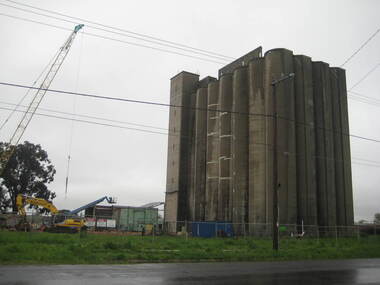 Ballarat Heritage Services
Photograph - Photograph - Colour, Lisa Gervasoni, Joe White Maltings Silos Under Demolition, 2010, 15/10/2010
"A plan to turn the Gregory Street silos into apartments is no more.Developers Eleveno Pty Ltd have abandoned plans to transform the Lake Wendouree silos into a giant apartment complex, despite previously being given the green light from the Victorian Civil and Administrative Tribunal.Director Richard Sykes yesterday confirmed the silos would be demolished."The plans are not proceeding. The plan now is to create residential houses," he said.The planning permit for an 18-lot subdivision was approved by Ballarat City Council on July 22, despite objections lodged against the application.Mr Sykes said it wasn't feasible to turn the silos into 27 units and there were many factors behind the decision."They're being demolished for various reasons, there were just better solutions," he said.Bold plans to transform the former Joe White Maltings silos into apartments were first submitted to Ballarat City Council in January 2007.However, developers took the proposal to VCAT in September 2008 after council failed to make a decision in the required 60-day timeframe.A hearing was held in early 2009 and the development was approved in March last year.Mr Sykes said it was found that the building would most likely be out of place in the region."We found the market didn't really want that sort of development," he said."They're probably more suited for inner-city development, rather than regional areas."Mr Sykes did not put a price on either the proposed development or the demolition, but said it would "cost a fair amount of money".He said once the demolition permit has been passed, works were expected to begin in November." (Ballarat Courier, 03 August 2010)Joe White Maltings Silos in Gregory Street Ballarat under demolition, to make way for a housing development. The silos were built on the banks of Lake Wendouree. joe white maltings, silo, eleveno pty ltd, lake wendouree, demolition, gregory street ballarat, wendouree parade, architecture