Showing 1049 items
matching earth
-
 Eltham District Historical Society Inc
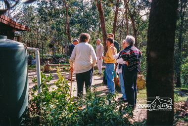
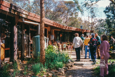
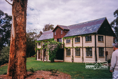
Photograph, Peter Bassett-Smith, Boomerang House, Laughing Waters Road, Eltham; Eltham Mud Brick Heritage Excursion, 4 October 1998, 04/10/1998
[article in EDHS Newsletter No. 123, November 1998:] MUD BRICK HERITAGE EXCURSION AND THE FUTURE. A small group of members attended the excursion on 4th October. We visited a number of earth houses listed by the Eltham Heritage Study in a very pleasant day's outing. The first visit was to the home of Jenny and Brian Ellis in York Street, formerly the home of Jenny's father Professor William McMahon Ball. We were made very welcome with inspection of the inside and outside showing the various stages of construction. We then walked through the grounds of "Kinloch", the Jelbart property in Arthur Street where we saw their large mud brick house and barn. Lunch was at Marion and Russell Yeoman's house in Peter Street. This pise house was built by the Moore family in the early 1950's. In the afternoon we visited the home of artist Jenni Mitchell in Fordhams Road, one of the last examples of the work of Alistair Knox. Then we travelled to Laughing Waters Road where we saw two interesting houses owned and built by well known landscape gardener Gordon Ford. Along the way we stopped to view a number of other properties from the street.Colour photographactivities, eltham, heritage excursion, mud brick, boomerang house, laughing waters road -
 Eltham District Historical Society Inc
Photograph, Peter Bassett-Smith, Rocknall, 25 Diamond Street, Eltham; Eltham Mud Brick Heritage Excursion, 4 October 1998, 04/10/1998
[article in EDHS Newsletter No. 123, November 1998:] MUD BRICK HERITAGE EXCURSION AND THE FUTURE. A small group of members attended the excursion on 4th October. We visited a number of earth houses listed by the Eltham Heritage Study in a very pleasant day's outing. The first visit was to the home of Jenny and Brian Ellis in York Street, formerly the home of Jenny's father Professor William McMahon Ball. We were made very welcome with inspection of the inside and outside showing the various stages of construction. We then walked through the grounds of "Kinloch", the Jelbart property in Arthur Street where we saw their large mud brick house and barn. Lunch was at Marion and Russell Yeoman's house in Peter Street. This pise house was built by the Moore family in the early 1950's. In the afternoon we visited the home of artist Jenni Mitchell in Fordhams Road, one of the last examples of the work of Alistair Knox. Then we travelled to Laughing Waters Road where we saw two interesting houses owned and built by well known landscape gardener Gordon Ford. Along the way we stopped to view a number of other properties from the street.Colour photographactivities, eltham, heritage excursion, mud brick, diamond street, rocknall -
 Eltham District Historical Society Inc
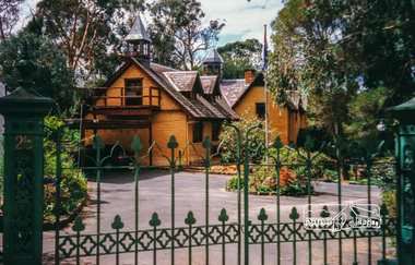
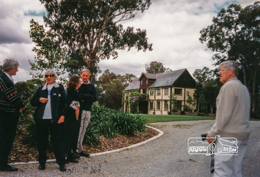
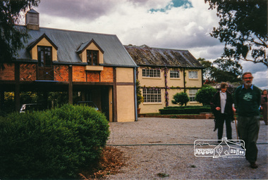
Photograph, Peter Bassett-Smith, Jelbart property, Arthur Street, Eltham Mud Brick Heritage Excursion, 4 October 1998, 04/10/1998
[article in EDHS Newsletter No. 123, November 1998:] MUD BRICK HERITAGE EXCURSION AND THE FUTURE. A small group of members attended the excursion on 4th October. We visited a number of earth houses listed by the Eltham Heritage Study in a very pleasant day's outing. The first visit was to the home of Jenny and Brian Ellis in York Street, formerly the home of Jenny's father Professor William McMahon Ball. We were made very welcome with inspection of the inside and outside showing the various stages of construction. We then walked through the grounds of "Kinloch", the Jelbart property in Arthur Street where we saw their large mud brick house and barn. Lunch was at Marion and Russell Yeoman's house in Peter Street. This pise house was built by the Moore family in the early 1950's. In the afternoon we visited the home of artist Jenni Mitchell in Fordhams Road, one of the last examples of the work of Alistair Knox. Then we travelled to Laughing Waters Road where we saw two interesting houses owned and built by well known landscape gardener Gordon Ford. Along the way we stopped to view a number of other properties from the street.Colour photographactivities, eltham, heritage excursion, mud brick, arthur street, jelbart property -
 Eltham District Historical Society Inc
Photograph, Peter Bassett-Smith, Cottage, Main Road, Eltham, Eltham Mud Brick Heritage Excursion, 4 October 1998, 04/10/1998
[article in EDHS Newsletter No. 123, November 1998:] MUD BRICK HERITAGE EXCURSION AND THE FUTURE. A small group of members attended the excursion on 4th October. We visited a number of earth houses listed by the Eltham Heritage Study in a very pleasant day's outing. The first visit was to the home of Jenny and Brian Ellis in York Street, formerly the home of Jenny's father Professor William McMahon Ball. We were made very welcome with inspection of the inside and outside showing the various stages of construction. We then walked through the grounds of "Kinloch", the Jelbart property in Arthur Street where we saw their large mud brick house and barn. Lunch was at Marion and Russell Yeoman's house in Peter Street. This pise house was built by the Moore family in the early 1950's. In the afternoon we visited the home of artist Jenni Mitchell in Fordhams Road, one of the last examples of the work of Alistair Knox. Then we travelled to Laughing Waters Road where we saw two interesting houses owned and built by well known landscape gardener Gordon Ford. Along the way we stopped to view a number of other properties from the street.Colour photographactivities, eltham, heritage excursion, mud brick, main road -
 Forests Commission Retired Personnel Association (FCRPA)
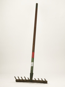
Rakut - Fire rake, Unknown FCV District, c 1952
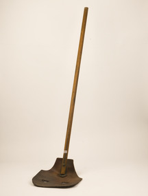
Bushfire perimeter rather than bushfire area is the main control problem for firefighters on the ground. A conundrum rapidly compounded by spot fires. A small 5 ha fire can be nearly 1 km around the perimeter. That's a long way to build a control line by hand in rough bush. Dry firefighting techniques by hand were mostly confined to “knocking down” or “beating out” the flames, as well as "digging out". Digging or raking a “mineral earth” trail down to bare dirt proved most effective in forest fuels which, unlike grass, tend to retain heat and smoulder. Early tools were whatever happened to be close at hand. They were simple and primitive and included shovels, slashers, axes, hoes, beaters and rakes. A cut branch to beat the flames was often the only thing available. Farming and logging tools, developed over centuries of manual labour, and readily available at local hardware stores came into use, but little thought was given to size, weight, and balance. For years foresters experimented with combination tools. In about 1952 fire beaters and other implements were being replaced with Rakuts.Fire tool used before the introduction of RakehoesRakut - Fire Rake and cutting toolGreen and red coloured handle and 020 marking indicated which FCV District the tool belonged tobushfire -
 Nillumbik Shire Council
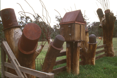
Sculpture: Tony Trembath (b.1946 Sale, Victoria), Tony Trembath, The Fences Act 1968 - Location: Edendale Farm (entrance) 30 Gastons Road, Eltham, 1989 - 1994
Eltham Council (now the Shire of Nillumbik) commissioned this work in 1989 to create an entrance / gateway to Edendale Community Farm. It was also aided by a grant from the Ministry of the Arts (now Arts Victoria). The former name of this work was "Gateway to Edendale Farm". Edendale Farm is a demonstration farm modelling sustainable environmental practices, providing support to the local residents of Nillumbik. Established in 1986, the land was purchased in 1970. It was previously an English gentleman's residence and was used for grazing. It consists of 5.6 hectares, with the Diamond Creek meandering through the property. The Victorian Fences Act 1968 governs liability of occupiers of adjoining lands to fence, and deals with disputes between neighbours regarding boundaries fences and costs. This work took into consideration ideas and suggestions from residents and committees, who required the use of recycled materials and that the work celebrate man's relationship with nature, animals and the earth, as well as relate to the fence-line on the far side of the carpark. Trembath also absorbed significant aspects of local history, making references to Eltham's agricultural past, the clearing of the land, the destruction of trees, the ruthless pruning of trees by suburban Councils and incorporated such Australian features as the post and rail fence. 'The Fences Act 1968' is significant for aesthetic, historic and social reasons at a regional level. It makes prominent the historical and social significance of Edendale and the rural aspects of Nillumbik. The use of existing tree stumps and salt pots in the work explores the iconography of the countryside such as the isolated farmhouse, pioneering farming practices, post and rail fencing and the regrowth of lopped trees. The title of the work, as well as the extensive community involvement in its creation, also makes reference to the Victorian Fences Act 1968, which makes neighbours jointly responsible for the cost of construction and maintenance of fences in the partitioning of land for settlement. 'The Fences Act 1968' has been classified as of regional significance by the National Trust of Australia. The work is an installation of wood and metal, approximately twenty five meters long. The design is very informal and rustic and runs the full width of the fence-line. It comprises groups of recycled tree trunks fitted with metal caps (chrome-nickel 'salt pots' that are shaped like tall bowler / top hats). Metal rods protrude from the trunks and some of these rods have metal birds. Two larger, sentinel-like stumps at the two outer ends have metal flame-like wings, which bend inward. To the left of the entrance, a simple architectural element indicates an isolated farmhouse. The rustic fence runs between the groups of tree trunks with native planting in clumps along it. The fence-line incorporates a functional engineered double gate and post and rail fencing. There may be many interpretations of the work and the intention is to stimulate interest and imagination rather than alienate. Interpretation is based on the personal experience that a visitor brings. The artist recommended that no explanation of the design logic be positioned with the work. N/Apublic art, sculpture, edendale, recycled, wood, metal, fences act 1968, gate, trembath, salt pot, tree stumps -
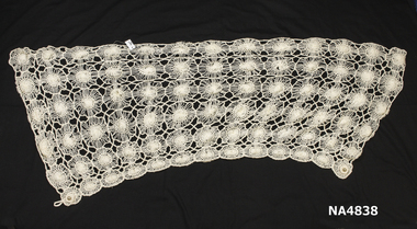 Whitehorse Historical Society Inc.
Clothing - Cape, 1997
I have lived in Box Hill now City of Whitehorse since 1970 I have belonged to Box Hill Spinners and Weavers Inc. since 1990.During the 90s' Box Hill Spinners and Weavers participated in the Annual Sheep and Woolcraft Show, at that time held in the Melbourne Showground. As well as submitting individual entries we always entered the Group Competition, known as the '5 articles' the entry had to have 5 separate articles made by a group and displaying different woolcraft techniques . In 1997 our Box Hill entry focused on 'The Planets' featuring five capes. The red one representing Mars the red planet. It was woven. The dark cape represented Jupiter. It was also woven. the Neptune cape was felted in blue and greens. The Earth cape featured knitting and crochet. My contribution was the Venus cape featuring spinning from raw merino fleece and silk. Once completed this wool/silk yarn was fashioned using hairpin lace. I was adept at spinning by this time but knew nothing about the old technique of hairpin lace. Box Hill Spinners and Weavers won First Prize. Margaret Dimelow.Cream coloured cape spun from raw merino fleece and silk, technique is hairpin lacecostume, female -
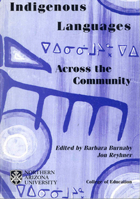 Victorian Aboriginal Corporation for Languages
Conference proceedings, Barbara Burnaby, Indigenous languages across the community, 2002
Language - Preservation and use. Language - Social function. [Maori: New Zealand Latin]. Language planning. [Language planning in a trans-national speech community]. [The way of the drum - when earth becomes heart] [The need for an ecological cultural community] Community language management. [Methods of madness: The Tuscarora Language Committee] [Daghida: Cold Lake First Nation works towards Dene language revitalization] [The Jicarilla Apache language summer day camp] [Report on the workshop "World of Inukitut"]. Arizona. New Mexico. Oklahoma. Adult education. Women's literacy. [Teaching reading with puppets] [Assessing Lakota language teaching issues on the Cheyenne River Reservation] [Incorporating traditional Nehiyaw/Plains Cree education in the university] [Collecting texts in Crao and Portuguese for teaching] [Early vocabularies and dictionary development: A cautionary note] [The process of spelling standardization of Innu-Aimun (Montagnais)] Pidgin. Creole. [Ojibway hockey CD-ROM in the making] [The use of multimedia and the arts in language revitalization, maintenance and development: The case of the Balsas Nahuas of Guerreo, Mexico] [The languages of Indigenous Peoples in Chukotka and the media] [Meeting of the Inukitut and Yupik family of languages on May 12, 2000]B&w photographs, diagrams,international language forum, community based practice, language research, conference papers, language policy, language and whole community development, literacy development, media, educational advances, canada, united states, new zealand, zimbabwe, mexico, russia, caribbean, inui, yupik -
 Eltham District Historical Society Inc
Audio Compact Cassette Tape, Audio Recording; 2003-09-10 Speaker Panel: Builders of the Eltham Tradition, 2003
September Meeting (Newsletter No. 152, Sep. 2003) This meeting is one in an occasional series where we get together a panel of speakers to talk about a particular aspect of Eltham's history, its character or its people. As has been the case for past speaker panels, we have organised a buff et dinner to precede the meeting and details of this are given below. Eltham has a well-known tradition of building with mud brick, second hand materials and other innovative or uncommon materials. Although this trend dates mainly from the 1930 's there are examples from the pioneer days of Eltham. Part of the Brocksopp house at Eltham South is an 1850' s mud brick construction by George Souter. But the alternative building tradition in Eltham really began at Montsalvat in the 1930's. Justus Jorgensen's building complex of earth construction, stone and items from wreckers' yards inspired a number of builders and owner builders, particularly in adopting mud brick or adobe as their building medium. The tradition continues today with our area remaining home to a relatively high proportion of builders using these alternative materials. The panel we have selected to talk on this subject are either builders in the Eltham tradition or have had close contact with builders of the past. The panel will be introduced by Russell Yeoman who will talk briefly about George Stebbing, an early Eltham builder responsible for many of our remaining historic buildings, but known for traditional buildings of his time rather than the later buildings which give Eltham its particular character. The panel members are as follows:- • John Pizzey, architect. John will speak on the work of Alistair Knox designer and builder in mud brick and the person who has most contributed to the environmental building traditions of Eltham. • Peter Jarvis who will talk about his own work as a builder in mud brick and his views on traditional and modern construction methods. • Leigh Wykes, a present day builder of stone houses, will talk about his own work in the district and its relevance to Eltham traditions. • Diana Bassett-Smith will talk about her experience with owner-builders constructing their earth houses in Eltham in the 1950's. Pise and mud brick presented a cheap building material provided that you could do it yourself or persuade your friends to help. Prior to the meeting there will be a buffet dinner of casseroles and other courses prepared by some of our members. We will be starting at 6.00pm with dinner scheduled for 6.30. Harry Gilham will be providing drinks, including wines from his personally made collection. Cost of the dinner will be $10 which can be paid on the night. However, for catering purposes we need to know numbersCompact audio cassette Sony EF 90 Type I / IEC I Cassette labelled "Eltham Builders Historical" Converted to MP3 file; 100MB, 1:18:57 alistair knox, audio cassette, audio recording, building construction, diana bassett-smith, eltham, john pizzey, leigh wykes, peter jarvis, society meeting -
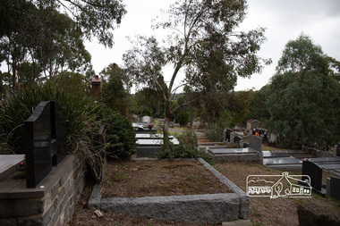 Eltham District Historical Society Inc
Photograph, Peter Pidgeon, Memorial to Alistair Knox, Eltham Cemetery, Victoria, 5 April 2021
Alistair Knox was an architect and builder who came to Eltham in 1948. Influenced by Frank Lloyd Wright and Walter Burley Griffin, he sought to create buildings that would blend into the landscape, enhanced by the planting of indigenous flora. The post-war shortage of building materials made traditional construction expensive. Adobe (mudbrick) provided a cheap and plentiful alternative, and one which would be aesthetically pleasing. Mud-brick manufacture was a problem at first. Sonia Skipper had been experimenting with Eltham clays for years to find the best mix for making bricks and render. Alistair employed her as building foreman on several of his sites. By the 1980s, he had brought mud-brick and earth building into the Australian mainstream, and a Knox-designed house had become highly desirable. Sonia said that he would craft a bespoke earthen house to fit with his client's lifestyle. He was drawn to the environmental movement, publishing three books on housing and the environment, and speaking on radio. He also served on the Eltham Shire Council 1971-1975, was Shire President 1974 and was instrumental in re-establishing the Eltham Community Festival in 1975. Alistair died in 1986 and is buried in a small garden setting at Eltham Cemetery.Born Digitaleltham cemetery, gravestones, heritage excursion, alistair knox -
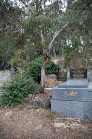 Eltham District Historical Society Inc
Photograph, Peter Pidgeon, Grave of Alistair Samuel Knox, Eltham Cemetery, Victoria, 5 April 2021
Alistair Knox was an architect and builder who came to Eltham in 1948. Influenced by Frank Lloyd Wright and Walter Burley Griffin, he sought to create buildings that would blend into the landscape, enhanced by the planting of indigenous flora. The post-war shortage of building materials made traditional construction expensive. Adobe (mudbrick) provided a cheap and plentiful alternative, and one which would be aesthetically pleasing. Mud-brick manufacture was a problem at first. Sonia Skipper had been experimenting with Eltham clays for years to find the best mix for making bricks and render. Alistair employed her as building foreman on several of his sites. By the 1980s, he had brought mud-brick and earth building into the Australian mainstream, and a Knox-designed house had become highly desirable. Sonia said that he would craft a bespoke earthen house to fit with his client's lifestyle. He was drawn to the environmental movement, publishing three books on housing and the environment, and speaking on radio. He also served on the Eltham Shire Council 1971-1975, was Shire President 1974 and was instrumental in re-establishing the Eltham Community Festival in 1975. Alistair died in 1986 and is buried in a small garden setting at Eltham Cemetery.Born Digitaleltham cemetery, gravestones, heritage excursion, alistair samuel knox -
 Ballarat Heritage Services
Photograph - Image - Black and White, Macaroni Factory, Hepburn Springs, 1900, 1900
"MACARONI MANUFACTORY. On the pretty road to the Hepburn Mineral Springs, and not far from where the health-laden waters gush plentifully from the earth, is a two-storied brick it is that Messrs Lucini and Co, carry building, dedicated to the manufacture of macaroni, vermicelli, and the Italians' own especial delight— spaghetti. Here on operations, and Mr Lucini himself was good enough to show the writer around and explain the various proces ses of a manufacture which is little known to Australians. The finest wheat and the mineral waters fresh from the springs are utilised, and by means of a most ingenious machine, the hollow rods of macaroni are turned out in large numbers. Finally, they are packed in boxes and cases, and sent off to the prin cipal agent in Daylesford, Mr J. W. King, who in turn forwards them to all parts of the country. Mr Blackett, thv Govrnment Analyst, writes in most lau datory manner of the productions of the factory, and says that on testing them he found the various sam ples were of excellent quality, and quite equal to any of Italian manufacture. Visitors to the springs should not fail to call in at Messrs Lucini's, which is one of the show places of the district, and will well repay an inspection.A number of women, members of the Lucini family, make macroni and the macaroni factory in Hepburn Springs. lucini, macaroni factory, hepburn springs, spaghetti, macaroni -
 Wodonga & District Historical Society Inc
Album - Hume Reservoir Australia Album - Preparing a paddock for concrete. August 1927, 1927
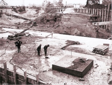
This set of photos is from a leather bound album bearing the inscription "HUME RESERVOIR AUSTRALIA" plus 'The Rt. Hon. L. C. M. S. Amery, P. C., M .P.' all inscribed in gold. It was presented to The Rt. Hon. L. C. M. S. Amery, P. C., M. P, Secretary of State for Dominion Affairs on the occasion of his visit to the Hume Reservoir on 2nd November 1927. This album is of local and national significance as it documents the planning and development of the Hume Reservoir up to 1927. It was the largest water reservoir in the British Empire. The album records the pioneering engineering work that went into its construction.DEPARTMENT OF PUBLIC WORKS, N.S.W. RIVER MURRAY WATERS SCHEME. HUME RESERVOIR. 27. Preparing a Paddock for Concrete. Great care is taken in cleaning the surface of the concrete before placing the next layer. A hose applies a jet of water with a pressure of about 150 pounds to remove laitance and all dirt, which is swept off with brooms. (Laitance is the weak, milky or powdery layer of cement dust, lime and sand fines that appear on the surface of concrete. ) The square block of concrete in the foreground is poured at the same time as the concrete surrounding it and acts as a key for the next layer. Usually large granite “plums” or displacers weighing from 2 tons to 8 tons are used for this purpose and are placed in position by the cableway, but while the cableway is out of action the other method has been adopted. In this view may also be seen some of the timber piles and sheeting which form the inner side of the coffer dam. The outer side is formed of steel sheet piling. The space between the two lines of piles is 20 feet wide and is filled with earth after the steel and timber lines have been bound together by steel tie rods. New South Wales, August 1927.hume reservoir australia, river murray waters scheme, hume reservoir construction -
 Wodonga & District Historical Society Inc
Album - Hume Reservoir Australia Album - Detail plan and explanation, Department of Public Works, N.S.W, 1927
This set of photos is from a leather bound album bearing the inscription "HUME RESERVOIR AUSTRALIA" plus 'The Rt. Hon. L. C. M. S. Amery, P. C., M .P.' all inscribed in gold. It was presented to The Rt. Hon. L. C. M. S. Amery, P. C., M. P, Secretary of State for Dominion Affairs on the occasion of his visit to the Hume Reservoir on 2nd November 1927. This album is of local and national significance as it documents the planning and development of the Hume Reservoir up to 1927. It was the largest water reservoir in the British Empire. The album records the pioneering engineering work that went into its construction.2. Detail Plan and Section. Starting from the New South Wales and there will be an earthen embankment 430 feet 6 inches long which is retained by the North Wing Wall. Then come the sluice section 284 feet 3 inches long, the spillway 720 feet long and the South Wing Wall, making a total length of 1,042 feet 6 inches of concrete wall. Beyond the South Wing Wall is earth embankment again to a length of 3,827 feet. The Full Supply Level is R.L.626.00 and allowance has been made for a surcharge of 9 feet. A road will run along the top of the dam at R.L.642.00. The sluice section contains seven offlets, the three nearest the north wing wall being 13 feet in diameter for hydro-electric purposes and the other four 9 feet in diameter for regulation purposes only. There are to be stony sluice gates on the upstream ends of the outlets and needle valves on the downstream ends. The shock of the discharged water will be taken by a stilling pool. Trash racks will protect the intake ends of the outlets. Next comes the spillway section, which is curved on the downstream face, and carried up to within 15 feet of the full supply level. Above that will be a series of piers between which will be the flood gates and on top of which the roadway will be carried. The gates will be 20 feet wide and 15 feet high and will be 29 in number. They will slide down the face of the wall when opened for the escape of the water. The investigation of the control of this cascade of water was made by means of a model and as a result the form of “bucket” or energy dissipater shown on the section of the spillway was decided upon. The earth embankment in Victoria is being constructed by the State Rivers and Water Supply Commission of Victoria who are the Constructing Authority for that State under the River Murray Waters Agreement. The core of the embankment is of concrete 6 feet wide at the base tapering to 2 feet at the top end and is reinforced with steel rods from the level of the decomposed rock upwards. On the downstream side, at about natural surface level, is a tunnel for drainage and inspection purposes. Above the tunnel is a vertical layer of large stones to drain any seepage to the tunnel. Against the core wall is packed selected material of as impervious a character as can be got locally and beyond that the bank is carefully built up in horizontal layers by means of horses and wheel scoops. The upstream slope is 3-to-1 hardening to 2½-to-1 at the top and the downstream slope is 2½-to-1 hardening to 2.07-to-1 at the top. The thrust of the upstream toe is taken by a mass of granite blocks, and this face is protected by concrete laid in situ. The width of the bank at base is 650 feet and at top 32 feet.hume reservoir australia, river murray waters scheme, hume weir diagrams, hume plan details -
 Eltham District Historical Society Inc
Photograph, The Rose Stereograph Company, Plenty River, Greensborough, c.1939
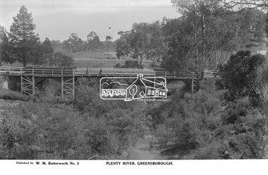
View looking northwest along the Plenty River towards the original bluestone Greensborough Bridge (since demolished). A timber pedestrian footbridge added after construction is visible with two people crossing. In the distance is a wide flat verge, now present day Carter Reserve and on the far side seven men digging and a set of terraced steps dug out in the earth bank. Present day Pioneer Reserve is to the right of the river in foreground. This glass plate negative was used to manufacture postcards (1:1 printing) for commercial sale by the Rose Sterograph Company and its subsidiaries. George Rose founded the Rose Stereograph Company in 1880 and was joined by Herbert (Bert) Cutts in the early 20th Century. The pair formed a lifetime working partnership and strong personal friendship. Assisted by George’s two sons, Herbert George and Walter, and later by Neil Cutts, the Rose Stereograph Company continued its operations for more than 140 years. The company was initially built on stereographs, but as cinema took over and stereographs fell out of fashion, the Rose Stereograph Company developed Australia’s first commercially viable photographic postcard business. Specialising in postcards of iconic historical moments and significant landmarks, The Rose Stereograph Company became a staple of the Australian travel industry.This remarkable collection of glass plate negatives, transparencies, and postcards – arguably Australia’s most significant photography collection outside of public hands – has been passed down through the generations, surviving war, relocation, and the harsh Victorian climate. The historic Rose Stereograph collection is the culmination of George Rose’s dream of capturing and preserving precious moments in time and remains the legacy of the Rose and Cutts families. It is with great sadness that the Cutts family says goodbye to a collection that spans five generations and 140 years. The Cutts family understands that for these historically important pieces to rest with one family is to deny others the pleasure of their custodianship.Glass Plate Negative Size: 9 x 14 cmPlenty River, Greensborough, Published by W. M. Butterworh No. 2postcard, travel, rose stereograph company, glass plate negative, greensborough, carter reserve, footbridge, greensborough bridge, main road, plenty river, w. m. butterworth, pioneer reserve, construction, peter and elizabeth pidgeon collection -
 Bendigo Historical Society Inc.
Book - JOSEPH BRADY COLLECTION: NOTEBOOK, BENDIGO WATER WORKS - CRUSOE RESERVOIR AND OTHER CONTRACTS 1870 TO 1874
Dark green covered book with gold edging front and back and seven horizontal lines on the spine. On front cover: buff sticker, with Bendigo Water Works, Crusoe Reservoir and others, contracts 1870 - 1874 written in cursive script. Later writing 'from Mrs. H. Strickland, Bungoona, Currie, King Island'. Written inside is: Presented to Bendigo Historical Society by Mrs A Strickland, Bungoona, Currie, King Island. Also the Historical Society Stamp. The next page has three newspaper cuttings. The first is 'The Victorian Waterworks'. It has costings for contracts for water supply, amounts which will supply water from the Coliban to the Castlemaine and Sandhurst districts, and if the Government should purchase the Bendigo Waterworks, and to construct the Upper Coliban reservoir, additional expenditure may be required. (from Daily Telegraph - 1868). The second is some information on The Yan Yean Aqueduct. The third is a letter to the Editor of the Argus from Joseph Brady, dated August 2, 1870, in reference to repairing the leak in the outlet tunnel of the Malmsbury Reservoir. He says the repair of the tunnel was not essential and is unnecessary and 2nd. If the bank was cut through and restored, for years the bank would not be safe, as the earth used in the restoration would require time to subside and unite with the old work. He hopes the embankment would be allowed to stand intact.civil engineering, water supply, coliban, bendigo water works - crusoe reservoir and other contracts 1870 to 1874, mrs a strictland, royal historical society of victoria bendigo branch, coliban scheme, upper coliban reservoir, daily telegraph 1868, yan yean aqueduct, age, argus 2/8/1870, malmsbury reservoir, joseph brady, charles cook, fishburn morton & kennedy, bernard ward & co, the fulton foundry co ltd, james mcewan & co, laylands foundry co, melbourne sewers & water supply, c w gore, crusoe office, john mcilwraith, edward chandler, ia-s miller & co, robison br & co, guthrie/white hills pottery, peter mcpherson, slater & co, john danks, mclean br & rigg, william beebe, t i connelly, i horwoods -
 The Beechworth Burke Museum
Photograph
This photograph dates to 1899, towards the end of the gold rush in the Mopoke Gully area. A large opening to a mine can be seen behind the men in the photograph, with a wheeled cart on a track leading to the men's position, where the soil and rocks have been hauled away. This photograph interestingly contains dogs alongside the miners. While dogs have been recorded as deterrents to thieves in the Victorian goldfields, these dogs appear as companions to these men. Mopoke Gully mines came under the 'Fryer's Creek' division of the Castlemaine District during the Gold Rush. After the Gold Rush began in Victoria with the discovery of gold at Ballarat in 1851, Gold was found in Castlemaine by December of that year. 20,000 diggers were spread across the Castlemaine region, and the area was yielding about 23,000 ounces of gold per week. Mopoke Gully was the site of the Mopoke Gully Water Wheel, operating under the Bendigo and Fryers Goldmining Company from 1887 until 1900. This Water Wheel was used in the gold mining technique of 'sluicing'. Hydraulic sluicing uses high pressure water jets to blast away the earth, which runs through a sluice box, catching the gold with all remaining slurry washing away. This Water Wheel was built the same year as the more famous 'Chewton Water Wheel', but was smaller in diameter (60ft as opposed to Chewton's 72ft). The Mopoke Water Wheel ruins are quite intact today, and are a registered archaeological site. The search for gold is ingrained into the history of Victoria and therefore, images like this one can reveal important information for society and technology for the date when the photograph was taken. This image is of important historical significance for its ability to convey information about sluicing and the methods used to find gold in 1899. This photograph reveals important information on the use of dogs on Victorian goldfields in 1899. Dogs were used both as companions, such as this photograph depicts, as well as deterrents to thieves. Sepia coloured rectangular photograph printed on gloss photographic paper mounted on card. Obverse: Williams/ Good/ Luck Reverse: A02498/ 1997. 2498/ Good Luck/ Mine/ 1899/ Mopoke. beechworth, burke museum, gold, gold mining, 1899, castlemaine, mopoke gully, good luck mine, fryer's creek, gold rush, victorian gold rush, water wheel, sluicing, chewton -
 The Beechworth Burke Museum
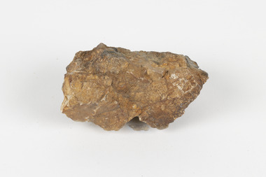
Geological specimen - Cassiterite
This specimen is Cassiterite in Quartz. Cassiterite is a tin oxide metal that forms in thin crystals which can have a beautiful lustre. Quartz is made of silicon dioxide, also known as silica, and is one of the most common minerals on earth. Cassiterite has been a fundamental source of tin ore for humans throughout history, including today. Tin is an important metal that has a wide variety of human uses in different areas, from dying fabric, to making mirrors, and their most well-known use ‘tin’ cans. Tin cans are primarily made of steel and are coated with tin in order to take advantage of tin’s property of being non-corroding. This is a massive step in the history of food preservation. Tinned food first reached Australia in 1815 with early settlers, and it began to be manufactured here in the 1840s. It was incredibly popular, and was a highly exported product, which would be a contributing factor to the ‘tin mining boom’ of the early 1880s. This specimen was collected at Jingellic, New South Wales, in about 1852. Although the Goldfields of the 1800s are much more well-known, tin mines existed alongside the gold mines which began in the mid 19th century and extended almost one hundred years, to the mid 20th century. Specimens like this would have been used as evidence to justify tin mining operations in the region as an investment. This specimen is part of a larger collection of geological and mineral specimens collected from around Australia (and some parts of the world) and donated to the Burke Museum between 1868-1880. A large percentage of these specimens were collected in Victoria as part of the Geological Survey of Victoria that begun in 1852 (in response to the Gold Rush) to study and map the geology of Victoria. Collecting geological specimens was an important part of mapping and understanding the scientific makeup of the earth. Many of these specimens were sent to research and collecting organisations across Australia, including the Burke Museum, to educate and encourage further study. The Geological Survey of Victoria was headed by British geologist, Alfred Richard Cecil Selwyn (1824-1902), who was responsible for issuing over 60 geological maps during his 17 years as director. These maps were all hand-drawn and coloured and became the benchmark for accuracy for geological mapping. Collecting geological specimens was an important part of mapping and understanding the scientific makeup of the earth. Many of these specimens were sent to research and collecting organisations across Australia, including the Burke Museum, to educate and encourage further study. A fist-sized solid geological specimen made on one half of tin oxide, which is dark grey, and on the other side of silica, which is brown and cream.burke museum, beechworth, geological, geological specimen -
 El Dorado Museum Association Inc.
Photograph (item) - Digital Image
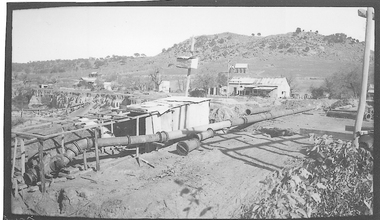
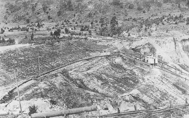
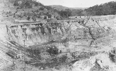
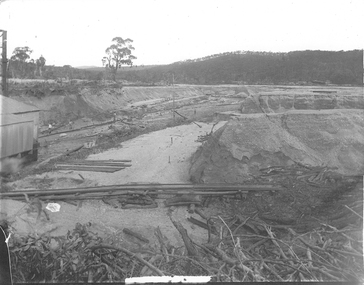
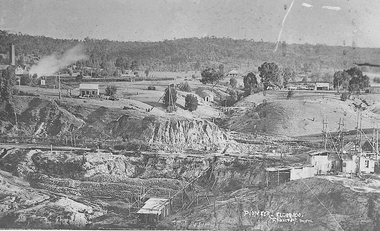
Cocks Pioneer Electric Gold & Tin Mine Company was formed in 1899. The company's first power station, located at the eastern end of the valley began operating with its 340 Kilowatt steam-powered generator. By 1909, from 2,500,000 cubic yards worked, reported recovery was 17,284 ounces of gold and 224 tons of tin ore. By 1909, Cocks Pioneer’s power plant had become inadequate and uneconomical. The barge was floated downstream about a mile, but lost time caused the operations to cease. Following testing, a new mine was established by diverting Reid's Creek at a cost of £25,000. Settling dams were built, one of which held 1,935,900 cubic feet. Sold earth banks, built against a wall of stringy bark saplings constructed and laced with vertical props, were built. In 1914, the company was reformed as Cock’s Pioneer Gold and Tin Mines NL, another power station was constructed at the western end of the township, near the junction of Clear and Reid's Creeks. From 6,800,000 cubic yards of material processed, the returns were 64,397 ounces of gold and 855 ton of tin. Cocks Pioneer mine then moved the barge downs stream and continued sluicing. In 1929 Cocks Pioneer Electric Gold and Tin Mining Company ceased operations due to a drop in values. Cock’s Pioneer Gold and Tin Mines NL carried on large-scale hydraulic sluicing operations until 1941. mining, gold, tin, barge, sluicing, gold mining, tin mining, cocks pioneer, el dorado, eldorado -
 El Dorado Museum Association Inc.
Photograph (item) - Digital Image
Cocks Pioneer Electric Gold & Tin Mine Company was formed in 1899. The company's first power station, located at the eastern end of the valley began operating with its 340 Kilowatt steam-powered generator. By 1909, from 2,500,000 cubic yards worked, reported recovery was 17,284 ounces of gold and 224 tons of tin ore. By 1909, Cocks Pioneer’s power plant had become inadequate and uneconomical. The barge was floated downstream about a mile, but lost time caused the operations to cease. Following testing, a new mine was established by diverting Reid's Creek at a cost of £25 000. Settling dams were built, one of which held 1,935,900 cubic feet. Sold earth banks, built against a wall of stringy bark saplings constructed and laced with vertical props, were built. In 1914, the company was reformed as Cock’s Pioneer Gold and Tin Mines NL, another power station was constructed at the western end of the township, near the junction of Clear and Reid's Creeks. From 6,800,000 cubic yards of material processed, the returns were 64,397 ounces of gold and 855 ton of tin. Cocks Pioneer mine then moved the barge downs stream and continued sluicing. In 1929 Cocks Pioneer Electric Gold and Tin Mining Company ceased operations due to a drop in values. Cock’s Pioneer Gold and Tin Mines NL carried on large-scale hydraulic sluicing operations until 1941. gold, tin, mining, sluicing, gold mining, tin mining, cocks pioneer, el dorado, eldorado -
 El Dorado Museum Association Inc.
Photograph (item) - Digital Image
Cocks Pioneer Electric Gold & Tin Mine Company was formed in 1899. The company's first power station, located at the eastern end of the valley began operating with its 340 Kilowatt steam-powered generator. By 1909, from 2,500,000 cubic yards worked, reported recovery was 17,284 ounces of gold and 224 tons of tin ore. By 1909, Cocks Pioneer’s power plant had become inadequate and uneconomical. The barge was floated downstream about a mile, but lost time caused the operations to cease. Following testing, a new mine was established by diverting Reid's Creek at a cost of £25,000. Settling dams were built, one of which held 1,935,900 cubic feet. Sold earth banks, built against a wall of stringy bark saplings constructed and laced with vertical props, were built. In 1914, the company was reformed as Cock’s Pioneer Gold and Tin Mines NL, another power station was constructed at the western end of the township, near the junction of Clear and Reid's Creeks. From 6,800,000 cubic yards of material processed, the returns were 64,397 ounces of gold and 855 ton of tin. Cocks Pioneer mine then moved the barge downs stream and continued sluicing. In 1929 Cocks Pioneer Electric Gold and Tin Mining Company ceased operations due to a drop in values. Cock’s Pioneer Gold and Tin Mines NL carried on large-scale hydraulic sluicing operations until 1941. mines, mining, tin, gold, tin mining, gold mining, sluicing, cocks pioneer, el dorado, eldorado -
 El Dorado Museum Association Inc.
Photograph (item) - Digital Image
Cocks Pioneer Electric Gold & Tin Mine Company was formed in 1899. The company's first power station, located at the eastern end of the valley began operating with its 340 Kilowatt steam-powered generator. By 1909, from 2,500,000 cubic yards worked, reported recovery was 17,284 ounces of gold and 224 tons of tin ore. By 1909, Cocks Pioneer’s power plant had become inadequate and uneconomical. The barge was floated downstream about a mile, but lost time caused the operations to cease. Following testing, a new mine was established by diverting Reid's Creek at a cost of £25 000. Settling dams were built, one of which held 1,935,900 cubic feet. Sold earth banks, built against a wall of stringy bark saplings constructed and laced with vertical props, were built. In 1914, the company was reformed as Cock’s Pioneer Gold and Tin Mines NL, another power station was constructed at the western end of the township, near the junction of Clear and Reid's Creeks. From 6,800,000 cubic yards of material processed, the returns were 64,397 ounces of gold and 855 ton of tin. Cocks Pioneer mine then moved the barge downs stream and continued sluicing. In 1929 Cocks Pioneer Electric Gold and Tin Mining Company ceased operations due to a drop in values. Cock’s Pioneer Gold and Tin Mines NL carried on large-scale hydraulic sluicing operations until 1941. mining, mines, gold, tin, gold mining, tin mining, sluicing, cocks pioneer, el dorado, eldorado -
 El Dorado Museum Association Inc.
Photograph (item) - Digital Image
Cocks Pioneer Electric Gold & Tin Mine Company was formed in 1899. The company's first power station, located at the eastern end of the valley began operating with its 340 Kilowatt steam-powered generator. By 1909, from 2,500,000 cubic yards worked, reported recovery was 17,284 ounces of gold and 224 tons of tin ore. By 1909, Cocks Pioneer’s power plant had become inadequate and uneconomical. The barge was floated downstream about a mile, but lost time caused the operations to cease. Following testing, a new mine was established by diverting Reid's Creek at a cost of £25 000. Settling dams were built, one of which held 1,935,900 cubic feet. Sold earth banks, built against a wall of stringy bark saplings constructed and laced with vertical props, were built. In 1914, the company was reformed as Cock’s Pioneer Gold and Tin Mines NL, another power station was constructed at the western end of the township, near the junction of Clear and Reid's Creeks. From 6,800,000 cubic yards of material processed, the returns were 64,397 ounces of gold and 855 ton of tin. Cocks Pioneer mine then moved the barge downs stream and continued sluicing. In 1929 Cocks Pioneer Electric Gold and Tin Mining Company ceased operations due to a drop in values. Cock’s Pioneer Gold and Tin Mines NL carried on large-scale hydraulic sluicing operations until 1941. Handwritten across photograph: "PIONEER" - ELDORADO / F FOXCROFT PHOTO.mining, mines, gold, tin, gold mining, tin mining, sluicing, cocks pioneer, el dorado, eldorado -
 Forests Commission Retired Personnel Association (FCRPA)
Fire Beater - Leather, c 1940s
Bushfire perimeter rather than bushfire area is the main control problem for firefighters on the ground. A conundrum rapidly compounded by spot fires. A small 5 ha fire can be nearly 1 km around the perimeter. That's a long way to build a control line by hand in rough bush. Dry firefighting techniques by hand were mostly confined to “knocking down” or “beating out” the flames, as well as "digging out". Digging or raking a “mineral earth” trail down to bare dirt proved most effective in forest fuels which, unlike grass, tend to retain heat and smoulder. Early tools were whatever happened to be close at hand. They were simple and primitive and included shovels, slashers, axes, hoes, beaters and rakes. A cut branch to beat the flames was often the only thing available. Farming and logging tools, developed over centuries of manual labour, and readily available at local hardware stores came into use, but little thought was given to size, weight, and balance. This leather beater was based on a century-old stockman's design which used green cow hide leather lashed to a broom handle. It's recommend that users lift no more than above knee height to conserve energy and let the beater to the work. For years foresters experimented with combination tools. In about 1952 fire beaters and other implements were being replaced with Rakuts and later RakehoesEarly firefighting toolBushfire beater - Leather with wooden handlebushfire -
 National Communication Museum
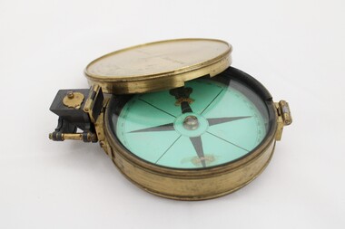
Equipment - Prismatic compass, Alfred E Sawtell, before 1872
After years of precursory surveying, debate and proposals the most ambitious civil engineering project of the day, the Overland Telegraph Line, began construction in September 1870. Superintendent of Telegraphs, Sir Charles Todd led the construction through “terra incognita,” guided by the precursory surveys of John McDowall Stuart and technologies such as his prismatic surveying compass. The unknown and hostile landscape claimed the lives of several men and scores of transport animals in the dogged pursuit of telegraphic connection to the rest of the world. Completed in August 1872, the Line connected Australia to the world via telegraph wires running 3,200 kilometres from Port Augusta in South Australia, to Darwin, then connecting via submarine cable to Java and beyond. The “earth [had been] girdled with a magic chain” according to the then Governor of New South Wales, Sir Hercules Robinson. How does it work? For use in surveying, the sight vane and prism are turned up on their hinge and the instrument is held horizontally either in the palm of one's hand or on a tripod. Two small discs of red and green glass attached to the prism can be flipped down over the sight line to reduce glare. The objective is to bring the subject into the sightline created by the prism, aligning with the thread of the sight-vane until the subject is bisected evenly. Once aligned, the division on the card may be read through the prism. This reading provides the magnetic azimuth, used for calculating the bearings of distant landmarks. Circular instrument mounted in a brass case with glass window and brass lid. The compass card face four black compass points printed on mint green paper; on the underside the magnetic needle would be affixed, all held in place by a brass knob at the centre. The arched labels of "Sawtell" and "Adelaide" and the Prince of Wales feathers appear to have been affixed with adhesive which has since yellowed in the areas of application on the compass card. The compass face is printed with numbers, every 10 degrees from 10 - 360, printed in reverse indicating this compass would have once held a mirror at the sighting bracket. On one side of the brass case is a brass hinged sighting-prism, possibly of ebonite. The sighting-prism is mounted in a hinged brass bracket on one edge of the brass case. It has two flip-type filter glasses (red and green) and folds down into a retracted travelling position. A hinged brass bracket on the opposite edge would have held the sighting bracket - carrying the sighting vane and mirror - which is now missing or removed. Under the hinge is a lever, possibly related to the movement of the bracket. Underneath the brass case is an indented circle with screw threads, possibly for attachment to a tripod, and indistinguishable marks scratched into the surface.Etched on to the centre of the lid, "Sawtell ADELAIDE / No 792." Affixed to the paper compass face, possibly from separate pieces of paper, "SAWTELL / ADELAIDE" with the Prince of Wales Feathers above "SAWTELL". Underneath on remains of white tape in red: "159."surveying, compass, charles todd, overland telegraph line, telegraph -
 Bendigo Historical Society Inc.
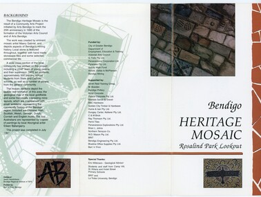
Pamphlet - MERLE HALL COLLECTION: ROSALIND PARK CREATIVE VILLAGE BENDIGO PROJECT PAMPHLET, 1995
Merle Hall Collection: Rosalind Park Creative Village Bendigo Project Pamphlet for Rosalind Park Lookout - two copies. One side of the pamphlet has a layout image of the five sections of the mosaic and the poppet head base. The sections are numbers 1 to 5 Section 1: A stylised representation of the main Bendigo Goldfield based on a geological plan (Publish in 1992). It shows the lines of reef, including the famous Hustlers, Garden Gully and New Chum. Section 2: A typical cross section of the Bendigo Goldfields Section 3: The mine layout shown in this design features part of the Garden Gully line of reef. Section 4: Shown here is the Iron Bark mine on the Sheepshead reef. It has an interesting pattern of drives, stopes and winzes. Section 5: In this section the artist uses gold as her inspiration. The larger mosaic shows quartz veins winding through the earth containing gold in its various forms. The smaller mosaic represents the atomic structure of gold. It shows the the nucleus, the six shells of the atom, their electrons and orbits. The other side of the pamphlet describes the background of the community arts project, the artist, and volunteer workers, also notes mentioning the Bendigo community history. It also lists the donors for funding and business's that supported the project, with special thanks to Eric Wilkinson - Geolpogical advoser, the students and staff from Camp Hill, St Killians and Violet Street primary schools. BRIT and La Trobe University, bendigo. -
 The Beechworth Burke Museum
Photograph
This photograph dates to 1899, towards the end of the gold rush in the Mopoke Gully area. A slurry of rocks after they have been broken up is depicted, and this is part of the hydraulic sluicing mining process. Four men are relaxing under a wooden structure, with a fifth bearded man standing near a stone wall. This photograph interestingly contains dogs alongside the miners. While dogs have been recorded as deterrents to thieves in the Victorian goldfields, these dogs appear as companions to these men. Mopoke Gully mines came under the 'Fryer's Creek' division of the Castlemaine District during the Gold Rush. After the Gold Rush began in Victoria with the discovery of gold at Ballarat in 1851, Gold was found in Castlemaine by December of that year. 20,000 diggers were spread across the Castlemaine region, and the area was yielding about 23,000 ounces of gold per week. Mopoke Gully was the site of the Mopoke Gully Water Wheel, operating under the Bendigo and Fryers Goldmining Company from 1887 until 1900. This Water Wheel was used in the gold mining technique of 'sluicing'. Hydraulic sluicing uses high pressure water jets to blast away the earth, which runs through a sluice box, catching the gold with all remaining slurry washing away. Hydraulicking is the process of breaking up the rocks and suspending it in a slurry. This Water Wheel was built the same year as the more famous 'Chewton Water Wheel', but was smaller in diameter (60ft as opposed to Chewton's 72ft). The Mopoke Water Wheel ruins are quite intact today, and are a registered archaeological site.The search for gold is ingrained into the history of Victoria and therefore, images like this one which portray a sluicing site can reveal important information for society and technology for the date when the photograph was taken. This image is of important historical significance for its ability to convey information about sluicing and the methods used to find gold in 1899. It also shows a location where sluicing was undertook which provides insight into the impact of sluicing on the environment at a time when it was done. This photograph reveals important information on the use of dogs on Victorian goldfields in 1899. Dogs were used both as companions, such as this photograph depicts, as well as deterrents to thieves. Sepia coloured rectangular photograph printed on gloss photographic paper mounted on card.Obverse: Reverse: A02497/ 1997.2497/ 'Good/ Luck/ Mine'/ Morepork/ Gully/ Mrs Joyce/ Bright/ Tunnel/ 800 ft/ 1899. beechworth, burke museum, gold, gold mining, 1899, castlemaine, mopoke gully, good luck mine, fryer's creek, gold rush, victorian gold rush, water wheel, sluicing, chewton, slurry