Showing 35196 items
matching healesville-shire-council
-
 Greensborough Historical Society
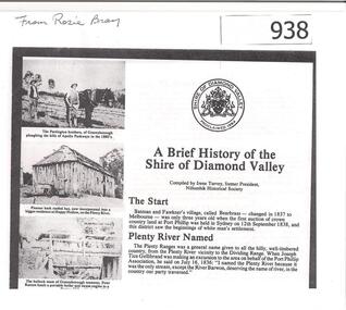
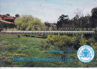
Article, Shire of Diamond Valley, A brief history of the Shire of Diamond Valley by Irene Turvey, 1837o
This brief history discusses the Shire of Diamond Valley. The Shire of Diamond Valley was a Local Government Area located about 20 kilometres northeast of Melbourne. The shire covered an area of 74.38 square kilometres and existed from 1964 until 1994.This article includes some images of early building in the Shire of Diamond Valley.Photocopied article. 4 pages text and illus.On front page "from Rosie Bray"shire of diamond valley, irene turvey -
 Greensborough Historical Society
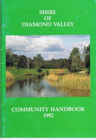
Book, Shire of Diamond Valley, Shire of Diamond Valley Community Handbook 1992, 1992_
Guide to services provided by Shire of Diamond Valley. The Shire of Diamond Valley was a Local Government Area located about 20 kilometres northeast of Melbourne. The shire covered an area of 74.38 square kilometres and existed from 1964 until 1994.Annual guide to services in Shire of Diamond Valley52 pages, col illus., maps. Cover illustration of Kalparrin Gardens Greensboroughshire of diamond valley -
 Learmonth and District Historical Society Inc.
Photo - Bregenzer, Richards & Co. Photos Ballaarat, H.Bregenzer, Secretary.1885-86, "Circa 1886"
Mr H. Bregenzer was Secretary of the Ballarat Shire Council for the council year 1885-86Section of Original Historic Photo of councilors and staff for the year 1885-86Sepia photo of Mr. H. Bregenzer is in the middle at the bottom of collection of photos of all councilors for 1885-86. It is oval in dark grey mount edged in gold. " PRESENTED BY THE PRESIDENT G.RENNIE ESQ.TO THE BALLARAT SHIRE COUNCIL.1885-86."1885 1886, ballarat shire council, bregenzer h secretary -
 Greensborough Historical Society
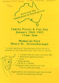
Flyer - Article and Leaflet, Greensborough Inter Church Council, Greensborough Interchurch Council. Family picnic and fun day 26/01/1995, 26/01/1995
The Greensborough Interchurch Council organised a family picnic and fun day on Australia Day 26/01/1995. Leaflet advertising the event and article by Rosie Bray2 p. Leaflet: blue text on yellow paper; article: black text on white papergreensborough interchurch council, australia day, picnics in greensborough -
 Eltham District Historical Society Inc
Negative - Photograph, Eltham Shire Council, Possibly a non-compliant house in Simms Road, Kinglake, c.1989
Facebook comments suggested this location may be a cabinetmaker by the name of Cook out the back of Panton Hill. Another comment recalled this man as a visitor to Montsalvat as a friend of the late poet, Geoffrey Egglestone. It is believed his name is Mizza. He is a Bohemium Poet. Also a frequent visitor to the St Andrews market. Photos taken by Eltham Shire Council officers most likely during an inspection of the property for non compliance. Other images on the roll of film are of Council Health officers undergoing food inspections at the shops, maternal health services and housing estate development inspectionsRoll of 35mm colour negative film, 6 strips Frames 3 through 9Fuji 100eltham shire council, shire of eltham, 1989, atlantic ethyl, sheds, signs, unidentified, houses, kinglake, simms road -
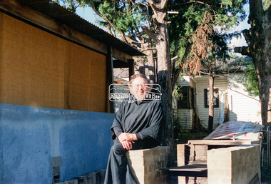
 Orbost & District Historical Society
folder of documents, 1970
Councillor J.D. Torley was the chair of this committee. The Bicentenary of James Cook in Australia was commemorated in Australia in 1970. The British explorer Lieutenant (later Captain) James Cook sailed and charted the East Coast of Australia in 1770, and claimed the eastern seaboard of the Continent for the British Crown. This was not considered the official bicentenary of Australia, but rather the mapping of the Eastern coastline.This item reflects the commemoration of a significant event in Australian history.750 is a red coloured plastic folder. The front cover has "SHIRE OF ORBOST" in gold print with the shire seal beneath it. It contains event programs, flyers, booklets, letter heads, souvenir programs, a catalogue for an art contest and minutes of the committee meetings. 750.1 is a manila folder which contains a program and tickets to the 1770 Ball held on Friday 17th April,1970. It also contains letter heads, envelopes and copies of correspondence concerning the Captain Cook 1970 centenary celebrations.cook-james centenary-1970 orbost-shire-council -
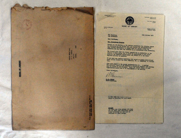 Orbost & District Historical Society
document, 18th October, 1977
This survey had been sent to the Orbost Rifle Club c/- C. Curtis.The Shire of Orbost was a local government area about 380 kilometres (236 mi) east of Melbourne, the state capital of Victoria, Australia. The shire covered an area of 9,347 square kilometres (3,608.9 sq mi), and existed from 1892 until 1994 when it was merged as part of East Gippsland Shire Council.A nine page document stapled in the left-hand corner. It is a recreational survey issued by the Shire of Orbost. It is inside a a large manila envelope which is addressed to the Orbost Rifle club. It contains a covering letter and a form.survey shire-of-orbost orbost-rifle-club -
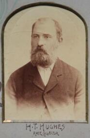 Learmonth and District Historical Society Inc.
Photo - Hughes, Richards & Co. Photos Ballaarat, Hughes. H.T. Councilor 1893 - 1894. (Rate Collector), 1894 (estimated)
Photo of Councilor H.T.Hughes, Rate Collector for the year 1893 -1894.Part of composite photo of Councilors for that year.Section of Original Historic Photo of Councilors covering the financial year 1893 - 1894.Sepia photo,on blue background,of Councilor H.T.Hughes,Rate Collector. Bottom right hand corner of composite photo of councilors for the year 1893 - 1894.Shire President and Councilors for the year 1893 -1894.shire, ballarat, council, 1893, 1894, hughes h t -
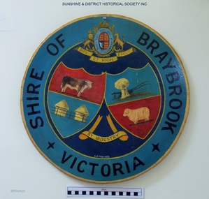 Sunshine and District Historical Society Incorporated
Plaque, A. H. Walker, COAT OF ARMS - Shire of Braybrook Victoria, Unknown date of manufacture
From around circa 1850 Braybrook was already well established and became a staging point for prospectors on their way to the diggings. Local government for this rural area to the west of Melbourne came when the BRAYBROOK ROAD DISTRICT was proclaimed on 28 May 1860. This authority was superseded on 23 January 1871 with the formation of the SHIRE OF BRAYBROOK. The Shire of Braybrook existed for about 80 years during which time it experienced significant industrial growth. The Shire of Braybrook ceased to exist in 1951 when the CITY OF SUNSHINE was formed.The Coat of Arms informs the observer that the Shire of Braybrook was initially a rural area with its images of a cow, sheep, and hay. The reference to industry however probably does not indicate adequately the large growth in industrial activity that occurred within the Shire. Circular board of Masonite painted by A. H. Walker which is a true depiction of the Coat of Arms for the Shire of Braybrook. It is mainly blue, yellow and red coloured with black writing, and has images of a cow, sheep, and hay, and also indicates a reference to industry.Shire of Braybrook Victoria / Dieu Et Mon Droit / By Industry / A. H. Walkercoat of arms, shire of braybrook, a. h. walker, plaque, sunshine -
 Eltham District Historical Society Inc
Document, OCM.004/12 Interim relocation of the Eltham Cenotaph; 11. Officer's reports, Ordinary Meeting of Council Agenda, 31 January 2012, pp16-19 and Attachment 1; OCM.004/12 Interim relocation of the Eltham Cenotaph; Funding Agreement Between Nillumbik Shire Council and Montmorency - Eltham RSL Sub Branch Inc., 31 January 2012, pp16-19, 2012
Relocation of the Eltham Cenotaph following the collapse of the Eltham RSL Sub-Branch9 A4 pages printedeltham cenotaph, eltham war memorial, montmorency-eltham rsl sub-branch, nillumbik shire council -
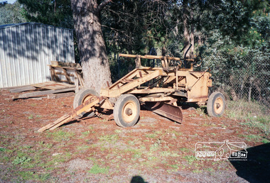 Eltham District Historical Society Inc
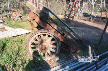
Photograph, Old Eltham Shire Council towed grader at the Council Depot, Hurstbridge
Roll of 35mm colour negative film, 2 stripsFuji 100eltham shire council, equipment, grader-towed, graders, roadmaking, trailers, shire of eltham -
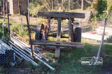 Eltham District Historical Society Inc
Photograph, Old Eltham Shire Council trailer at the Council Depot, Hurstbridge
Roll of 35mm colour negative film, 2 stripsFuji 100eltham shire council, equipment, trailers, shire of eltham -
 Eltham District Historical Society Inc
Photograph, Old Eltham Shire Council trailer at the Council Depot, Hurstbridge
Roll of 35mm colour negative film, 2 stripsFuji 100eltham shire council, equipment, trailers, shire of eltham -
 Greensborough Historical Society
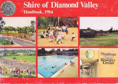
Booklet, Shire of Diamond Valley Handbook 1984, 1984_
Guide to services provided by Shire of Diamond Valley. The Shire of Diamond Valley was a Local Government Area located about 20 kilometres northeast of Melbourne. The shire covered an area of 74.38 square kilometres and existed from 1964 until 1994. Cover illustration of recreation facilities in Diamond Valley.Annual guide to services in Shire of Diamond Valley32 pages, col illus., maps. 2 copies.shire of diamond valley, greensborough, handbooks -
 Greensborough Historical Society
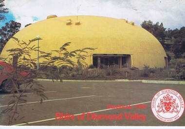
Booklet, The Shire of Diamond Valley Handbook 1981, 1981_
Guide to services provided by Shire of Diamond Valley. The Shire of Diamond Valley was a Local Government Area located about 20 kilometres northeast of Melbourne. The shire covered an area of 74.38 square kilometres and existed from 1964 until 1994. Cover illustration of "Diamond Creek Bini-shell".Annual guide to services in Shire of Diamond Valley28 pages, col illus., maps. (3 copies)shire of diamond valley, greensborough, handbooks -
 Greensborough Historical Society
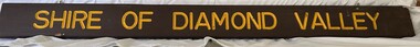
Sign, Shire of Diamond Valley, Shire of Diamond Valley: Park or Reserve sign, 1964-1994
Shire of Diamond Valley timber sign. This sign would have been at the entry to one of the many public parks and reserves created during the time of the Shire of Diamond Valley (1964-1994). Following the redistribution of local government areas in 1994, the previous Shire of Diamond Valley was split between City of Banyule and Shire of Nillumbik. Signage would have been replaced to reflect the new 'owners' of the property. The exact location of this sign is unknown.Brown painted Timber sign with yellow writing etched into timbershire of diamond valley, sign, parks - greensborough -
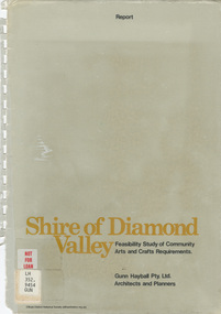 Eltham District Historical Society Inc
Book - Report, Gunn Hayball Pty Ltd Architects and Planners, Shire of Diamond Valley, Feasibility Study of Community Arts and Crafts Requirements, 1977
This report was prepared in response to a brief issued by the Shire of Diamond Valley to investigate the requirements for arts/crafts in the Shire and suggest options available in satisfying those requirements.Ex Yarra Plenty Regional Library - Local History, Dewey labels and catalogue stamp inside rear covershire of diamond valley, community arts and crafts, feasibility study -
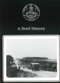 Greensborough Historical Society
Booklet, Shire of Corio, A Brief history of the Shire of Corio, 1980s
History of Shire of Corio, a local government area between Geelong and Werribee. The Shire included all of Geelong's northern suburbs and existed from 1861 to 1993.12 p., printed in green on white paper, photographs, stapled.geelong, shire of corio, werribee -
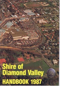 Greensborough Historical Society
Booklet, Shire of Diamond Valley Handbook 1987, 1987_
Guide to services provided by Shire of Diamond Valley. The Shire of Diamond Valley was a Local Government Area located about 20 kilometres northeast of Melbourne. The shire covered an area of 74.38 square kilometres and existed from 1964 until 1994. Cover illustration of aerial view of Greensborough shopping area and environs.Annual guide to services in Shire of Diamond Valley32 pages, col illus., maps. 2 copies.shire of diamond valley, greensborough, handbooks -
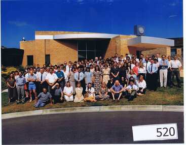 Greensborough Historical Society
Photograph (Framed), Shire of Diamond Valley, Shire of Diamond Valley Staff. Last day 1992, 1992_12
Photograph of "indoor" staff, Shire of Diamond Valley, on their last day at work for the Shire.The Shire of Diamond Valley was a Local Government Area located about 20 kilometres northeast of Melbourne. The shire covered an area of 74.38 square kilometres and existed from 30/09/1964 until 14/12/1994.Large colour photograph in timber frame.shire of diamond valley -
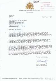 Greensborough Historical Society
Letter, Letter from Shire of Diamond Valley to Mrs Margaret Willimott 1987, 26/05/1987
Letter from Shire Engineer, Shire of Diamond Valley to Mrs Margaret Willimott of Watsonia High School, confirming a donation of plants for the school's 25th Anniversary Garden. Single page typed on letterhead.shire of diamond valley, watsonia high school, margaret willimott -
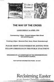 Greensborough Historical Society
Programme - Booklet, Greensborough Inter Church Council, Greensborough Interchurch Council. The way of the cross. Good Friday 01/04/1994, 01/04/1994
The Greensborough Interchurch Council held a Way of the Cross service on Good Friday 01/04/1994. Includes a press release and 4 newspaper clippings of local Easter services and community activities.8 p., black text on white paper, green cover, stapled in top left corner.greensborough interchurch council, church services, easter, way of the cross -
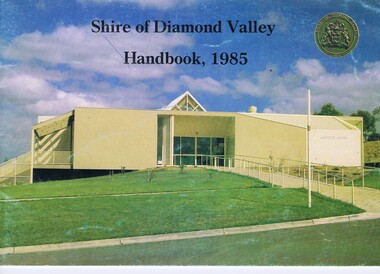 Greensborough Historical Society
Booklet, Shire of Diamond Valley Handbook 1985, 1985_
Guide to services provided by Shire of Diamond Valley. The Shire of Diamond Valley was a Local Government Area located about 20 kilometres northeast of Melbourne. The shire covered an area of 74.38 square kilometres and existed from 1964 until 1994. Cover illustration of Library/Arts facility at Civic Centre Greensborough, opened 1985.Annual guide to services in Shire of Diamond Valley32 pages, col illus., maps. 2 copies.shire of diamond valley, greensborough, handbooks -
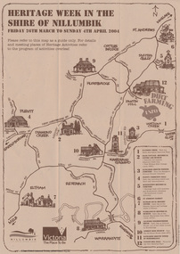 Eltham District Historical Society Inc
Booklet - Program, Shire of Nillumbik et al, Heritage Week in the Shire of Nillumbik, 2004
Map, with details of activitives presented by eight local history groups across the Shire of Nillumbik 26th March to Sunday 4th April 2004. Events included a dirt farming expo at Panton Hill. Program includes message by Mayor, Cr. Lex de Man and artwork by Syd Tunn. During the latter part of 2003 all of the historical societies and similar organisations in the Shire of Nillumbik attended a series of combined meetings arranged by Nillumbik Shire Council. The meetings were arranged by the Council's Arts and Cultural Services Co-ordinator and the Community Events Officer. ..The principal outcome of meetings ..to organise a Nillumbik Heritage Week to run from Friday 26th March to Sunday 4th April. The main event will be a combined heritage "expo" from 26th to 28th March, to be held in the Panton Hill Hall. The theme will be "Dirt Farming" which derives from the subsistence farming activities of the early settlers but could be widened to include gold mining, earth building and even modem day bushland regeneration. It fits well with the name "Nillumbik" which in the language of the Wurundjeri meant the not so good country covering most of our area and contrasted with the rich soil of the Kangaroo Grounds which they called Moor-rul. The following weekend each society will arrange their own separate activities. We intend to have open days at our Local History Centre on both days and this will include a display in the adjoining former Eltham Court House. We are also planning a heritage walk at 2.00pm on each day. Other groups will be having open days, displays, walks, guided car tours and other activities. - NL 154A3 sheet folded. Buff colour, with text and handrawn mapharry gilham collection, map, cultural heritage map, syd tunn, lex de man, eltham district historical society, nillumbik historical society, andrew ross museum, plenty historical society, st andrews queenstown historical society, warrandyte historical society, hurstbridge local history group -
 University of Melbourne, Burnley Campus Archives
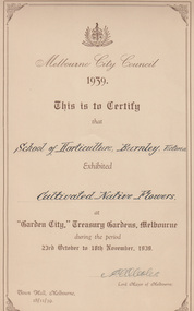
Certificate, Melbourne City Council 1939, 1939
Certificate issued by Melbourne City Council inscribed, 'This is to Certify that School of Horticulture Burnley Exhibited Cultivated Native Flowers at "Garden City," Treasury Gardens, Melbourne during the period 23rd October to 18th November, 1939, Town Hall, Melbourne. Signed by A.W. Coles, Lord Mayor of Melbourne.Certificate issued by Melbourne City CouncilCertificate issued by Melbourne City Council inscribed, 'This is to Certify that School of Horticulture Burnley Exhibited Cultivated Native Flowers at "Garden City," Treasury Gardens, Melbourne during the period 23rd October to 18th November, 1939, Town Hall, Melbourne. Signed by A.W. Coles, Lord Mayor of Melbourne.certificates, melbourne city council, flowers, plants, exhibition, treasury gardens, a.w.coles, 1939 -
 Greensborough Historical Society
Booklet, The Shire of Diamond Valley Handbook 1982, 1982_
Guide to services provided by Shire of Diamond Valley. The Shire of Diamond Valley was a Local Government Area located about 20 kilometres northeast of Melbourne. The shire covered an area of 74.38 square kilometres and existed from 1964 until 1994. Cover illustration of aqueduct and bridge over Plenty River near Apollo Parkways estste.Annual guide to services in Shire of Diamond Valley32 pages, col illus., maps. 2 copiesshire of diamond valley, greensborough, handbooks -
 Learmonth and District Historical Society Inc.
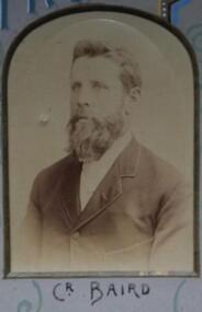
Photo - Baird 1893, Richards & Co, Baird. Councilor 1893 - 1894, 1894 (estimated)
Photo of Councilor C.C. Baird, 1893-1894.Part of composite photo for that year.Section of Original Historic Photo of Councilors, covering the financial year 1893-1894. Sepia photo of Councilor Baird 1893-1894. Top centre of composite photo of Council for the year 1893-1894.Shire President and Councilors for the year 1893-1894.ballarat shire council 1893 1894, c c baird -
 Greensborough Historical Society
Book, Shire of Eltham, Shire of Eltham Handbook 1988, 1988_
The Shire of Eltham was a Local Government Area located about 25 kilometres northeast of Melbourne. The shire covered an area of 277.13 square kilometres and existed from 1856 until 1994.Guide to services provided by Shire of Eltham52 pages, illus. Front cover is a copy of the painting "Panton Hill" by David Armfield.eltham, shire of eltham, handbooks -
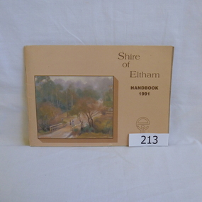 Greensborough Historical Society
Book, Shire of Eltham, Shire of Eltham Handbook 1991, 1991_
The Shire of Eltham was a Local Government Area located about 25 kilometres northeast of Melbourne. The shire covered an area of 277.13 square kilometres and existed from 1856 until 1994.Annual guide to services in Shire of Eltham60 pages, Illus. Printed on beige paper. Front cover has a copy of the painting "Brougham Street Bridge" by Hilary Jackman.eltham, shire of eltham, handbooks -
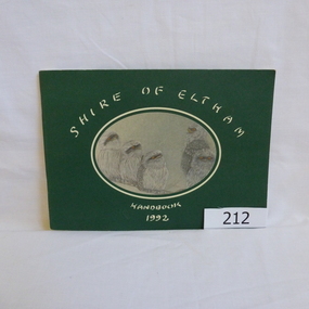 Greensborough Historical Society
Book, Shire of Eltham, Shire of Eltham Handbook 1992, 1992_
The Shire of Eltham was a Local Government Area located about 25 kilometres northeast of Melbourne. The shire covered an area of 277.13 square kilometres and existed from 1856 until 1994.Annual guide to services in Shire of Eltham72 pages, illus. Front cover has a copy of a sketch "Frogmouths" by Margo Kroyer Pederson on dark green cover. Printed on recycled paper.eltham, shire of eltham, handbooks