Showing 1133 items matching "kew east"
-
 Glenelg Shire Council Cultural Collection
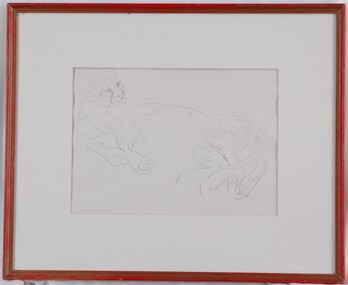
Drawing, Mary Macqueen, Cheetah, c. 1972
... : "Cheetah" $65 Drawing Mary Macqueen Iowen St East Kew 3102 803155... Macqueen Iowen St East Kew 3102 803155 Line drawing of a cheetah ...UnknownLine drawing of a cheetah reclining and looking over its shoulder to the right. Mounted in pale cream matt. In red wooden frame with glass glazing.Front: M. Macq (lower left, signature)(pencil) Back: "Cheetah" $65 Drawing Mary Macqueen Iowen St East Kew 3102 803155 -
 Kew Historical Society Inc
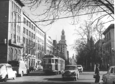
Photograph - K Class 217 (Birney Safety Car) in Doncaster & North Balwyn Village, 1990
... of East Kew Depot".... Original location of East Kew Depot" Laminated colour enlargement ...This colour photograph, with 15 others are enlargements gifted to the Society by Mel Lawrence in 2016. They were taken at a commemorative event from the Kew Tram Depot. Laminated colour enlargement of a K Class 217 (Birney Car) in Doncaster & North Balwyn Village taken at a re-enactment from the Kew Depot in 1990.Annotation reverse: "Kew Depot 1990. K Class 217 (Birney Car) in Doncaster & North Balwyn village. Original location of East Kew Depot"kew tram depot, k class trams, birney safety car -
 Port Melbourne Historical & Preservation Society
Document - Contract of Sale for 84 Dow Street, Port Melbourne, Law Institute of Victoria, 8 July 1982
... Fleming BARLOW of East Kew to Sydney William NEWMAN for the sum... BARLOW of East Kew to Sydney William NEWMAN for the sum of 875 ...The 1928 Contract of Sale is for the land which became 84 Dow Street, Port Melbourne. The land was sold by Catherine Fleming BARLOW of East Kew to Sydney William NEWMAN for the sum of 875 pounds. The deposit was 100 pounds with a quarterly re-payment of 10 pounds.Purchase completeddow street, built environment - domestic -
 Kew Historical Society Inc
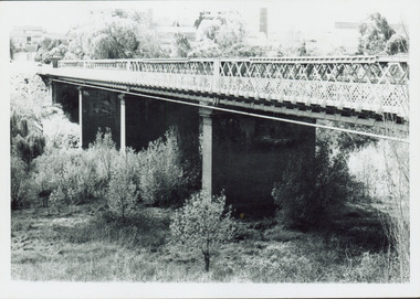
Photograph - Outer Circle Railway Viaduct
... between East Kew and Fairfield stations. In the 1930s... for the Outer Circle Railway to bridge the Yarra River between East Kew ...The heritage listed Fairfield Bridge was originally constructed for the Outer Circle Railway to bridge the Yarra River between East Kew and Fairfield stations. In the 1930s it was converted for vehicular traffic. In the 2010s a new concrete bridge was erected beside it to increase vehicular capacity.Print copy, enlarged from original snapshot, of the former railway viaduct crossing the Yarra and linking Kew and Fairfield. The original photo predates the conversion of the viaduct into the Chandler Highway Bridge in the 1930s, when the Bridge was adapted to carry vehicular traffic. The date on the reverse indicates the date of donation rather than the date on which the photograph was taken. CHANDLER HIGHWAY BRIDGE OVER RIVER / (ORIGINALLY PART OF OUTER CURCLE RAILWAY) / OCTOBER 1977railway viaduct -- kew (vic.), fairfield bridge, fairfield railway viaduct, outer circle railway, sir john monash -
 Kew Historical Society Inc
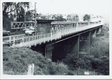
Photograph - Chandler Highway Bridge, 1977
... between East Kew and Fairfield stations. In the 1930s... for the Outer Circle Railway to bridge the Yarra River between East Kew ...The heritage listed Fairfield Bridge was originally constructed for the Outer Circle Railway to bridge the Yarra River between East Kew and Fairfield stations. In the 1930s it was converted for vehicular traffic. In the 2010s a new concrete bridge was erected beside it to increase vehicular capacity.Print copy of the Chandler Highway Bridge, [formerly the Fairfield Viaduct of the Outer Circle Railway] showing the original position of the walkway beside the bridge. The POV is from the Fairfield side looking towards Kew. CHANDLER HWY BRIDGE OVER YARRA / OCTOBER 1977 / ORIGINALLY BUILT FOR OUTER CIRCLE RWYchandler highway bridge, outer circle railway viaduct, bridges -- kew (vic.) -
 Melbourne Tram Museum
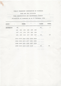
Administrative record - Depot List, Public Transport Corporation (PTC), "PTC Allocation of tramcars as at 01 December 1994", 1/12/1994
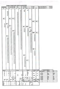
... Gives tram allocations for Brunswick, Camberwell, East... Gives tram allocations for Brunswick, Camberwell, East Preston ...Gives tram allocations for Brunswick, Camberwell, East Preston, Kew, Glenhuntly, Essendon, Malvern and South Melbourne. Also provides notes on tram with poles and pantographs.Yields information about tramcar allocation between various depots and workshops.Set of five double sided A4 photocopied sheets titled "PTC Allocation of tramcars as at 01 December 1994", trams, tramways, tramcars, ptc, lists, depots, depot allocation -
 Kew Historical Society Inc
Plan - Subdivision Plan, Maxwelton, Kew, 1920-1940
... The subdivision, ‘Maxwelton’, included four lots in East... of the City of Melbourne. Most of these are of Kew, Kew East ...Pru Sanderson, in her groundbreaking ‘City of Kew Urban Conservation Study : Volume 2 - Development History’ (1988), summarised the periods of urban development and subdivisions of land in Kew. The periods that she identified included 1845-1880, 1880-1893, 1893-1921, 1921-1933, 1933-1943, and Post-War Development. These periods were selected as they represented periods of rapid growth or decline in urban development. An obvious starting point for Sanderson’s groupings involved population growth and the associated economic cycles. These cycles also highlighted urban expansion onto land that was predominantly rural, although in other cases it represented the decline and breakup of large estates. A number of the plans in the Kew Historical Society’s collection can also be found in other collections, such as those of the State Library of Victoria and the Boroondara Library Service. A number are however unique to the collection.The Kew Historical Society collection includes almost 100 subdivision plans pertaining to suburbs of the City of Melbourne. Most of these are of Kew, Kew East or Studley Park, although a smaller number are plans of Camberwell, Deepdene, Balwyn and Hawthorn. It is believed that the majority of the plans were gifted to the Society by persons connected with the real estate firm - J. R. Mathers and McMillan, 136 Cotham Road, Kew. The Plans in the collection are rarely in pristine form, being working plans on which the agent would write notes and record lots sold and the prices of these. The subdivision plans are historically significant examples of the growth of urban Melbourne from the beginning of the 20th Century up until the 1980s. A number of the plans are double-sided and often include a photograph on the reverse. A number of the latter are by noted photographers such as J.E. Barnes.The subdivision, ‘Maxwelton’, included four lots in East Kew, at the northwest corner of Burke Road and Cotham Road. Lot 3 is identified as the location of an existing house. The site of the subdivision equates to that parcel of land where a contemporary block of three storey apartments at 1245 Burke Road is now located.subdivision plans - kew, mazwelton subdivision, burke road -- kew (vic.), cotham road -- kew (vic.) -
 Kew Historical Society Inc
Photograph - 8 roomed DF Brick Villa, Kew, J E Barnes, c.1920
... of the photograph is a subdivision plan for the Normanby Estate, East Kew... is a subdivision plan for the Normanby Estate, East Kew - 2016.0039.1 ...Subdivision plans are historically important documents used as evidence of the growth of suburbs in Australia. They frequently provide information about when the land was sold on which a built structure was subsequently constructed as well as evidence relating to surveyors and real estate and financial agents. The numerous subdivision plans in the Kew Historical Society's collection represent working documents, ranging from the initial sketches made in planning a subdivision to printed plans on which auctioneers or agents listed the prices for which individual lots were sold. In a number of cases, the reverse of a subdivision plan in the collection includes a photograph of a house that was also for sale by the agent. These photographs provide significant heritage information relating house design and decoration, fencing and household gardens. The photograph is of additional aesthetic significance as it was photographed by J. E. Barnes. Josiah Earl Barnes is a nationally significant photographer. He was also the most important photographer to have worked in Kew. He was active as a photographer in the district from c.1906 until his death in 1921. Best known as 'the Embarkation Photographer' (see the Australian War Memorial collection), J. Earl Barnes was also the official photographer employed by the Borough (and later Town, then City) of Kew. He clearly also completed commercial jobs for local businesses, as is the case in this photograph of a house for a local real estate and financial agent.A photograph, mounted on board of a double fronted Federation-era brick villa in Kew, photographed for a local real estate agent and financier by J. E. Barnes of Kew. On the reverse of the photograph is a subdivision plan for the Normanby Estate, East Kew - 2016.0039.1. As can be seen from the image, there is a large tear on the surface of the photograph.The brown card on which the photograph is mounted includes the following handwritten description, which may aid the identification of the house: "Kew, 3 minutes from tram, 8 roomed DF Brick Villa, tile roof including two attics, sleepout, bathroom, heater, E Light, Entrance Hall, double doors, leadlights, laundry, garden, lawns, land 75 x 170, 1975 pounds". Also photographers inscription on mount, lower left: J. E. Barnes / Photo / Phone 1966 Haw. KEW.j. e. barnes, josiah earl barnes, j. earl banes - photographer, architecture - federation style, houses - kew, real estate photographs -
 Kew Historical Society Inc
Photograph - Yarra in Flood - Belford & Kilby Farms, 1903
... ) of 22 Harp Road, East Kew, in whose yard the photograph..., East Kew, in whose yard the photograph was taken. A year before ...In 1980, Mr Laurie Bennett presented the Kew Historical Society with a number of photographs and postcards from the estate of his mother Eileen Mary Bennett (nee Clark). His mother was the daughter of Lawrence FH Clark(?-1946) and Mary Clark (?-1925) of 22 Harp Road, East Kew, in whose yard the photograph was taken. A year before the donation occurred a notice appeared in the Canberra Times stating that: "BENNETT, Eileen Mary. — May 8th at Tuross Heads, N.S.W. Late of 22 Harp Rd, East Kew, (Vic). Dearly loved wife of the late Harold Bennett, loved mother and mother in law of Laurie and Shirley (Melbourne), Kevin and Doreen (Canberra), grandmother of Linda, Stephen, Paul, Gabrielle, Peter, Mark and Jon."Part of a large collection of photographs and postcards in the collectionPanoramic photographic positive of North Kew where the Belford and Kilby Farms were located on the south side of the Yarra River. This photo, donated in 1980 by Laurie Bennett is the original of the two identical photos in the collection.laurie bennett, eileen mary bennett, eileen mary clark, floods -- yarra -- 1903 -
 Melbourne Legacy
Photograph, Leslie Thomson, Annual Demonstration 1970, 1970
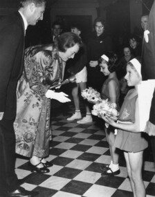
... Thompson 8 KEYSTONE CRES. EAST KEW WL 3078. ... Thompson 8 KEYSTONE CRES. EAST KEW WL 3078. Black and white photo ...Photograph of two Junior Legacy performers in costumes presenting flowers to Lady Delacombe, the wife of the Governor of Victoria - Sir Rohan Delacombe. One of the girls is Carmen Ellul, the other's name is not known. By the inscription it was at the Legacy on Parade in 1970 at the Melbourne Town Hall.A record of a Junior Legacy Demonstration being attended by the Governor of Victoria and his wife.Black and white photo of Junior Legacy performers presenting flowers to the Governor's wife.Back side of photo: Hand written 25 / Hand written, Legacy on Parade 1970 Lady Delacombe [Sign inserted] / Stamp, Leslie Thompson 8 KEYSTONE CRES. EAST KEW WL 3078. lady delacombe, legacy demonstration, governor of victoria -
Melbourne Tram Museum
Administrative record - Depot List, Public Transport Corporation (PTC), "PTC Allocation of tramcars as at 01 May 1994", May 1994
... Gives tram allocations for Brunswick, Camberwell, East... Gives tram allocations for Brunswick, Camberwell, East Preston ...Gives tram allocations for Brunswick, Camberwell, East Preston, Kew, Glenhuntly, Essendon, Malvern and South Melbourne. Includes Hawthorn, Newport, North Melbourne (Henderson Springs) and Thornbury locations where trams were stored.Yields information about tramcar allocation between various depots, storage facilities and workshops.Document - 19 A4 pages was stapled in top left hand corner.trams, tramways, ptc, depots, lists, depot allocation, stored trams -
 Kew Historical Society Inc
Plan - Subdivision Plan, Osburn Heights Estate, 1938
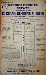
... on the subdivision’s proximity to East Kew. One section of the plan is includes... proximity to East Kew. One section of the plan is includes the text ...Edward Haughton & Co, in promoting the Osburn Heights Estate in what is now Balwyn North, attempted to capitalize on the subdivision’s proximity to East Kew. One section of the plan is includes the text: ‘The New Suburb: Camberwell North or East Kew (the names are synonymous)’. The Osburn Heights subdivision was part of a series of subdivisions running between Doncaster Road and Maud Street, including the ‘Pointed Firs Estate’ (MAP.0010). This subdivision included 13 ‘grand residential sites’ for sale in Doncaster Road, Maud Street and Osburn Avenue.subdivision plans - camberwell north, osburn heights estate -
 Ruyton Girls' School
Photograph, [Miss Beatrice Henty in the Garden of Tarring], 1904
... of her family home Tarring, Selbourne Road, Kew. The north east... Road, Kew. The north east and south facades of the two story ...Beatrice Charlotte Henty was born 25 December 1867, married Graham Frederick Blandy in 1927 and died on 5 March 1950 in Toorak. She did not have any children. Miss Beatrice Henty was the daughter of Henry and Marion Henty. Mr Henry Henty and his wife Mrs Marion Anne Henty (nee McKellar) had ‘Tarring’, Kew built for their family in 1872, and resided there until the death of Marion Henty in 1919. ‘Tarring’ was then sold to Ruyton Girls’ School, and the School moved to the site, (now 12 Selbourne Rd, Kew) in 1920. ‘Tarring’ was renamed ‘Henty House’ by Ruyton Girls' School in honour of its original owners. Ruyton Girls' School was founded in 1878, Miss Beatrice Henty attended the School before 1888. The photograph is dated c.1904. Sepia toned photograph Miss Beatrice Henty in the garden of her family home Tarring, Selbourne Road, Kew. The north east and south facades of the two story brick house are visible in the photo. Beatrice Henty is standing in the garden wearing a long gown and a large hat. A gravel path curves across the lower left corner of the photograph. The photograph is mounted on card.ruyton girls' school, kew, beatrice henty, henry henty, marion henty, tarring, henty house, selbourne road, beatrice blandy, kew (vic), 1900s, 1904 -
Kew Historical Society Inc
Archive (Sub-series) - Subject File, Baptist Church, 1958
... Grove, and the East Kew Baptist Church in Woodlands Avenue... in Highbury Grove, and the East Kew Baptist Church in Woodlands Avenue ...Various partiesReference, Research, InformationKHS OrderSubject file including a number of original and reproduced primary sources relating to the Kew Baptist Church in Highbury Grove, and the East Kew Baptist Church in Woodlands Avenue. These include ‘Kew Baptist: Young People’s Society of Christian Endeavour - Golden Jubilee 1890 to 1940’ [bound photocopy], ‘Kew Baptist Church: The Achievements and Progress during 75 years’ [bound photocopy], ‘Kew Baptist Church History 1856-1906’ [bound photocopy], ‘Kew Baptist Church: A Record of 75 Years 1856-1931’ [1st edition], and ‘Tested Recipes: Compiled by the Members of the East Kew Baptist Ladies Guild’ [original copy donated by Christine Pitt, Nunawading, 2013). In addition to these publications, three of which were donated in 1982 by Rev and Mrs Manton, the file contains research notes on Ministers (2015) and a letter relating to Church records.kew baptist church, churches - kew (vic.), highbury grove - kew (vic.)kew baptist church, churches - kew (vic.), highbury grove - kew (vic.) -
 Melbourne Tram Museum
Photograph - Tram 510? in Collins St, The Age Newspaper, 16-10-1954
... No. 510 (Kew Depot, route 47) east bound in Collins St... No. 510 (Kew Depot, route 47) east bound in Collins St ...Black and white photograph showing possibly W2 class tram No. 510 (Kew Depot, route 47) east bound in Collins St at Exhibition St. Has the T&G building in the background. The photo appeared in The Age centenary supplement on page 22. Yields information about Collins St and tram 510.Photograph with hand written notes on rear.Page 22 in pencil and "Collins Street East 16-10-54, The Age Centenary paper"trams, tramways, tram 510, collins st, w2 class -
 Melbourne Tram Museum
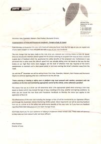
Document - Instruction, Yarra Trams, "Implementation of Rules and Procedures Handbook - Change to Rule 19: Speed", Nov. 2013
... . New rule to be applicable for Kew, Essendon, Malvern, East.... New rule to be applicable for Kew, Essendon, Malvern, East ...Instruction - single A4 sheet, advising of a change to the new rule book to come into use on Monday 11 November, titled "Implementation of Rules and Procedures Handbook - Change to Rule 19: Speed". Concerned with speed into tram stops and explains the basis of the proposed change. Year 2013 - based on Calendar. New rule to be applicable for Kew, Essendon, Malvern, East Preston and Brunswick depot until 8/12.trams, tramways, yarra trams, driver training, rules, tram stops -
 Kew Historical Society Inc
Plan, J R Mathers & McMillan, 5 Splendid vVlla Allotments,: Segtoune St. & Windsor St., Kew, 1928
... Street via Bridge Road and Flinders Street. Opposite the East Kew... Street via Bridge Road and Flinders Street. Opposite the East Kew ...Prue Sanderson, in her groundbreaking ‘City of Kew Urban Conservation Study : Volume 2 - Development History’ (1988), summarised the periods of urban development and subdivisions of land in Kew. The periods that she identified included 1845-1880, 1880-1893, 1893-1921, 1921-1933, 1933-1943, and Post-War Development. These periods were selected as they represented periods of rapid growth or decline in urban development. An obvious starting point for Sanderson’s groupings involved population growth and the associated economic cycles. These cycles also highlighted urban expansion onto land that was predominantly rural, although in other cases it represented the decline and breakup of large estates. A number of the plans in the Kew Historical Society’s collection can also be found in other collections, such as those of the State Library of Victoria and the Boroondara Library Service. A number are however unique to the collection.Subdivision plans are historically important documents used as evidence of the growth of suburbs in Australia. They frequently provide information about when the land was sold on which a built structure was subsequently constructed as well as evidence relating to surveyors and real estate and financial agents. The numerous subdivision plans in the Kew Historical Society's collection represent working documents, ranging from the initial sketches made in planning a subdivision to printed plans on which auctioneers or agents listed the prices for which individual lots were sold. In a number of cases, the reverse of a subdivision plan in the collection includes a photograph of a house that was also for sale by the agent. These photographs provide significant heritage information relating house design and decoration, fencing and household gardens.In 1928, five residential allotments bordering Segtoune and Windsor Streets were advertised for sale as part of a subdivision. Four of the blocks faced Segtoune Avenue. The auctioneers proclaimed the advantages of the sites: ‘Situate one minute from the High Street Electric Tram, which now runs direct to Spencer Street via Bridge Road and Flinders Street. Opposite the East Kew Railway Station (Outer Circle Line), which may be reopened In connection with the new Line from Kew to Doncaster; Adjacent lo the Kew Recreation Reserve, Sports Oval, and Swimming Bath; Half Minute from the Shopping Centre of East Kew, Accessible to the State School and Other Educational Centres’. The Harp of Erin Hotel and the route of the Outer Circle Railway line are marked on the plan. The Recreation Reserve and Sport Oval refer to Victoria Park. The Swimming Baths were located on the site of the current Kew Recreation Centre.subdivision plans - kew, segtoune street -- kew (vic.), windsor street -- kew (vic.) -
 Kew Historical Society Inc
Photograph - Studley Park, 1937
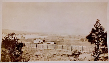
... , then it might be a view of what is now East Kew, taken from a section..., then it might be a view of what is now East Kew, taken from a section ...Those sections of Studley Park closest to the River Yarra were set aside as parkland in the 1850s. After initial discussions about whether it was a suitable site for a Government House, much of the land was instead gazetted in the 1860s as the location for a new lunatic asylum, to expand overcrowded mental health facilities at the Yarra Bend Asylum on the other side of the river at Fairfield. Those sections of Studley Park bounded by the Yarra River, Studley Park Road, Princess Street and Fellows Street were subdivided and sold at the Crown Land Sales in 1851. Much of this urban area remained open farmland until the twentieth century, apart from mansions, largely located along the main roads.Original, black and white positive print of what is said to represent Studley Park in 1937. If the attribution and date is literally to be understood, then it would appear that the photograph may have been taken from the Kew side of the river looking across to open farmland in the Yarra Bend Park. If the designation of Studley Park is to be understood more loosely, then it might be a view of what is now East Kew, taken from a section of Kilby Road. Inscribed verso: "Studley Park 1937" studley park -- kew (vic.) -
![Painting: Park Street [Adeney Avenue] Kew](/media/collectors/550653872162f11fb04854aa/items/5826877cd0cdd11284ad5413/item-media/614ac683a53a0756fd5e49da/item-fit-380x285.jpg) Kew Historical Society Inc
Kew Historical Society IncPainting, Park Street [Adeney Avenue] Kew, c. 1896
... depicting what is now known as East Kew with mountains... what is now known as East Kew with mountains on the horizon ...‘Adeney Avenue’ was the title given to this painting following its donation to the Kew Historical Society, yet the work’s origins predate the naming of Adeney Avenue in 1907 [originally gazetted as ‘Park Street’ (1865) and ‘Park Street South’ (1875).] Park Street ran between High Street and Parkhill Road beside what was later to become ‘Victoria Park’. This area was described in 1851 as “…a dense forest of gums and wattles which were to be largely cleared by 1888 after the naming of a recreation reserve”. The Reserve was still bisected by an unnamed creek in 1896, when the area was surveyed by the MMBW. The panoramic vista selected by the artist would appear to include ‘Eborensis’ (c.1895) on the corner of Parkhill Road and what was then Park Street, with views across cleared land towards the distant ranges. In the 19th century, north Kew was largely undeveloped farms stretching down to the Yarra. Oil on canvas by an unidentified artist of a panoramic view depicting what is now known as East Kew with mountains on the horizon. In the foreground is a two storey brick residence - Eborensis - located on the northeast corner of Parkhill Road and what is now Adeney Avenue. The view of the landscape and its rolling hills resulted from farming practices adopted following colonisation and settlement. Trees in the foreground and in the distance include remnant Eucalypts and introduced exotics.Label on rear of frame states "House on corner of Adeney Ave & Parkhill. [Regd. 254"]. Otherwise unsigned and undatedadeney avenue (kew), eborensis, park street (kew) -
 Kew Historical Society Inc
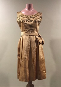
Clothing, Phil Bacon, Gold Satin Cocktail Dress with Beaded Bodice, 1950s
... was once owned and worn by a resident of East Kew.... by a resident of East Kew. women's clothing australian fashion ...The Fashion & Design collection of the Kew Historical Society includes examples of women’s, men’s, children’s and infants’ clothing from the 18th, 19th and 20th centuries. Items in the collection were largely produced for, or purchased by women in Melbourne, and includes examples of outerwear, protective wear, nightwear, underwear and costume accessories. Phil Bacon was one of a number of Melbourne fashion manufacturers who emerged in Melbourne following the Second World War. The cocktail dress was once owned and worn by a resident of East Kew.Gold satin cocktail dress, gathered at the waist with beading on the bodice. The zipped opening is at the back.women's clothing, australian fashion - melbourne - 1950s, cocktail dresses, phil bacon -
 Ringwood and District Historical Society
Map - State Aerial Survey, Dandenong Ranges Area Sheet 7, Parishes of Warrandyte, Scoresby, Ringwood and Nunawading - 1956
... not eventuate, including Village of Studley Estate, Township of East Kew... not eventuate, including Village of Studley Estate, Township of East Kew ...Map of central and southern areas of Ringwood and part of Ringwood East and Heathmont compiled by Dept of Lands and Survey, July 1956, from aerial photographs and Cadastral Survey information. Subsequent coloured hand-drawn additions showing layout of a number of post-NSW Separation era proposed subdivisions that did not eventuate, including Village of Studley Estate, Township of East Kew Estate, Township of Ballyduffy Estate, Township of New Flemington Estate, Township of East Hawthorne Estate. Ringwood A4B2, 849 A4B Zone 7. Scale: 10 chains to 1 inch. Contour interval 20 feet. -
Kew Historical Society Inc
Archive (Sub-series) - Subject File, Kew Historical Society, KEMP, Henry H, 1958
... to send a greeting by Henry H Kemp, Heald Lawn East Kew, donated..., Heald Lawn East Kew, donated by Mr & Mrs Jean Dyke, 1981. KEMP ...Various partiesReference, Research, InformationSecondary Values (KHS Imposed Order)Subject file containing historical notes on the architect Henry H. Kemp, summarised from a discussion with Mary Kemp, as well as a photocopy of a newspaper article on 7 Adeney Avenue, and a photocopy of Historic Environment Vol.2, No.2, 1882, containing an article by George Tibbits on “The So-Called Melbourne Domestic Queen Anne". The file includes an original business card used to send a greeting by Henry H Kemp, Heald Lawn East Kew, donated by Mr & Mrs Jean Dyke, 1981.kew - history, architects - victoria - henry kemp, henry h kemp, heald lawn - 5 adeney avenue - kew (vic)kew - history, architects - victoria - henry kemp, henry h kemp, heald lawn - 5 adeney avenue - kew (vic) -
 Kew Historical Society Inc
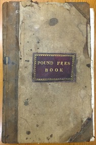
Administrative record (item), Borough of Kew, Pound Fees Book, 1874-1896
... , [East] Kew. Mr. J. Smith of Laburnum donated the register... register of the Glass Creek Pound, [East] Kew. Mr. J. Smith ...While the first successful land sales in Boroondara occurred in Hawthorn in 1843, and Kew in 1845, these areas were to be without local pounds until April 1858, when the Governor of Victoria, in accordance with Act 18 Victoria No 30, was pleased to direct the establishment of a Pound at Glass’s Creek on that part of land bounded by the Kilby Road, Burke Road and High Street. While the Governor was required to proclaim the establishment of a pound, the appointment of a poundkeeper was the responsibility of the Justices of the Peace in the local Court of Petty Sessions. The Pound took its name from the most distinctive natural feature of the area, Glass’s Creek, named after the early pastoralist Thomas Glass.The register is of historic significance as an indicator of suburban life in the second half of the 19th Century. It shows how farming and city life on the urban fringe were intimately connected. It is also significant to the early history of Hawthorn and Kew, who both claimed the Pound following their separation from the Boroondara Roads Board in 1861."Kew Pound Book"glass creek pound (kew), animal pound, dog pound, kew pound, j. smith, john oakes, samuel b. cash, edward s. delaney, emma oswin, samuel cash -
 Melbourne Tram Museum
Administrative record - Depot List, Melbourne & Metropolitan Tramways Board (MMTB), "Yarra Tram Fleet Depot Allocation - 6/5/1998", May. 1998
... , East Preston, Kew, Southbank and Preston Workshop storage... for Camberwell, East Preston, Kew, Southbank and Preston Workshop storage ...386.1 - A4 photocopied sheet titled "Yarra Tram Fleet Depot Allocation", dated 6/5/1998, giving tram allocations for Camberwell, East Preston, Kew, Southbank and Preston Workshop storage. Also provided details of recent tram movements. 386.2 - ditto for 18/5/1998. Second copy signed by A. Chircop, Inspecting Foreman.trams, tramways, tramcars, yarra trams, lists, depots, depot allocation -
 Kew Historical Society Inc
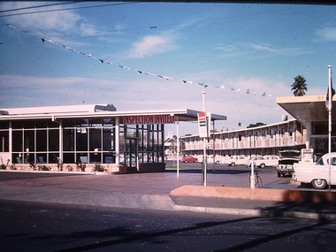
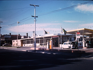
Photograph - California Motel, Barkers Road, Ron Setford, 1961
... Avenue, East Kew, from c.1946 to c.1995. A keen photographer, he... Avenue, East Kew, from c.1946 to c.1995. A keen photographer, he ...Ron Setford and his wife Grace Setford lived in Tanner Avenue, East Kew, from c.1946 to c.1995. A keen photographer, he recorded the changing face of Kew over a 20 year period. Apart from 30 photographs of built structures and places in Kew dating from 1960 and 1961, 145 of his 35mm colour slides chronicle the development of the Eastern Freeway through the Yarra Valley over a five year period from c.1972 to c.1977. This important collection was donated to the Society by his granddaughter in 2025.This collection of 175 35mm slides is of local and statewide significance, owing to its subject matter, particularly the major development of road transport infrastructure during the 1970s with the construction of the Eastern Freeway. The photographer also took care to annotate and date most of his slides which enable the researcher to pinpoint temporal and spatial locations.Opened in 1960, the California Motel at 138 Barkers Road, Hawthorn, was located opposite the entrance to Xavier College and built on the site of the former Barker railway station of the closed Kew branch line. The motel was advertised as “away from the hustle and bustle of the city and offering affordable accommodation for the business or leisure traveller”. Special amenities included air-conditioning, a business centre, and swimming pool. The motel had 82 suites. A possibly forgotten, but perhaps essential feature of the motel, was the Caltex Service Station at its entrance. The building was closed in April 2008, extensively vandalised and finally demolished in 2013."California Motel"ron setford, photographs -- kew (vic.) -- 1960s, california motel -- barkers road -- hawthorn (vic.) -
 Kew Historical Society Inc
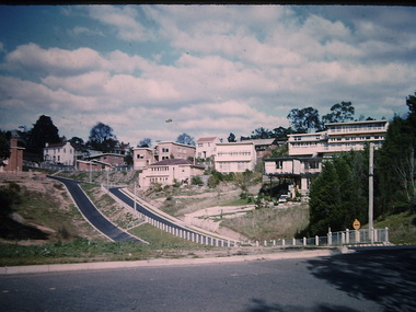
Photograph - Yarra Street, Kew, Ron Setford, 1960
... Avenue, East Kew, from c.1946 to c.1995. A keen photographer, he... Avenue, East Kew, from c.1946 to c.1995. A keen photographer, he ...Ron Setford and his wife Grace Setford lived in Tanner Avenue, East Kew, from c.1946 to c.1995. A keen photographer, he recorded the changing face of Kew over a 20 year period. Apart from 30 photographs of built structures and places in Kew dating from 1960 and 1961, 145 of his 35mm colour slides chronicle the development of the Eastern Freeway through the Yarra Valley over a five year period from c.1972 to c.1977. This important collection was donated to the Society by his granddaughter in 2025.This collection of 175 35mm slides is of local and statewide significance, owing to its subject matter, particularly the major development of road transport infrastructure during the 1970s with the construction of the Eastern Freeway. The photographer also took care to annotate and date most of his slides which enable the researcher to pinpoint temporal and spatial locations.Yarra Street was not made a trafficable thoroughfare until October 1956. Until then, the gully was used as a dump, a shortcut to the river, and for communal Guy Fawkes night bonfires. The open landscape in the photo reflects near-total clearing by the original estate owners for grazing livestock. Post-war homes fronting Stawell St dot the landscape. Of particular note are the Broons House (c.1952–54) by Anatol Kagan (top right), and the homes of two architects, Kurt Elsner (c.1950) (middle) and Geoffrey Danne (c.1954) (lower right). Dual carriageways made blocks accessible, but building was difficult due to steeply sloping land and complex drainage easements. Nevertheless, these challenges resulted in highly innovative designs, making Yarra Street the core of the Yarra Boulevard Heritage Precinct."Yarra St Kew"ron setford, photographs -- kew (vic.) -- 1960s, yarra street -- kew (vic.) -
 Kew Historical Society Inc
Photograph - California Motel, Barkers Road, Kew, Ron Setford, 1961
... Avenue, East Kew, from c.1946 to c.1995. A keen photographer, he... Avenue, East Kew, from c.1946 to c.1995. A keen photographer, he ...Ron Setford and his wife Grace Setford lived in Tanner Avenue, East Kew, from c.1946 to c.1995. A keen photographer, he recorded the changing face of Kew over a 20 year period. Apart from 30 photographs of built structures and places in Kew dating from 1960 and 1961, 145 of his 35mm colour slides chronicle the development of the Eastern Freeway through the Yarra Valley over a five year period from c.1972 to c.1977. This important collection was donated to the Society by his granddaughter in 2025.This collection of 175 35mm slides is of local and statewide significance, owing to its subject matter, particularly the major development of road transport infrastructure during the 1970s with the construction of the Eastern Freeway. The photographer also took care to annotate and date most of his slides which enable the researcher to pinpoint temporal and spatial locations.Opened in 1960, the California Motel at 138 Barkers Road, Hawthorn, was located opposite the entrance to Xavier College and built on the site of the former Barker railway station of the closed Kew branch line. The motel was advertised as “away from the hustle and bustle of the city and offering affordable accommodation for the business or leisure traveller”. Special amenities included air-conditioning, a business centre, and swimming pool. The motel had 82 suites. A possibly forgotten, but perhaps essential feature of the motel, was the Caltex Service Station at its entrance. The building was closed in April 2008, extensively vandalised and finally demolished in 2013.Nilron setford, photographs -- kew (vic.) -- 1960s, california hotel -- barkers road -- hawthorn (vic.), california motel -- barkers road -
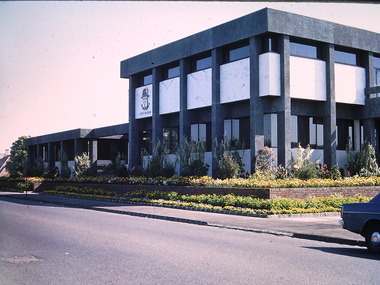 Kew Historical Society Inc
Photograph - Kew Civic Offices, Ron Setford, 1973
... Avenue, East Kew, from c.1946 to c.1995. A keen photographer, he... Avenue, East Kew, from c.1946 to c.1995. A keen photographer, he ...Ron Setford and his wife Grace Setford lived in Tanner Avenue, East Kew, from c.1946 to c.1995. A keen photographer, he recorded the changing face of Kew over a 20 year period. Apart from 30 photographs of built structures and places in Kew dating from 1960 and 1961, 145 of his 35mm colour slides chronicle the development of the Eastern Freeway through the Yarra Valley over a five year period from c.1972 to c.1977. This important collection was donated to the Society by his granddaughter in 2025.This collection of 175 35mm slides is of local and statewide significance, owing to its subject matter, particularly the major development of road transport infrastructure during the 1970s with the construction of the Eastern Freeway. The photographer also took care to annotate and date most of his slides which enable the researcher to pinpoint temporal and spatial locations."Kew - "Taj-Mahal" / Cotham Rd - Charles St / Oct 73"ron setford, kew civic offices -
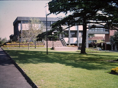 Kew Historical Society Inc
Photograph - Kew Civic Offices, Ron Setford, 1973
... Avenue, East Kew, from c.1946 to c.1995. A keen photographer, he... Avenue, East Kew, from c.1946 to c.1995. A keen photographer, he ...Ron Setford and his wife Grace Setford lived in Tanner Avenue, East Kew, from c.1946 to c.1995. A keen photographer, he recorded the changing face of Kew over a 20 year period. Apart from 30 photographs of built structures and places in Kew dating from 1960 and 1961, 145 of his 35mm colour slides chronicle the development of the Eastern Freeway through the Yarra Valley over a five year period from c.1972 to c.1977. This important collection was donated to the Society by his granddaughter in 2025.This collection of 175 35mm slides is of local and statewide significance, owing to its subject matter, particularly the major development of road transport infrastructure during the 1970s with the construction of the Eastern Freeway. The photographer also took care to annotate and date most of his slides which enable the researcher to pinpoint temporal and spatial locations."Kew Taj-Mahal"ron setford, kew civic offices -
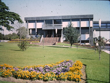 Kew Historical Society Inc
Photograph - Kew Civic Offices, Ron Setford, 1973
... Avenue, East Kew, from c.1946 to c.1995. A keen photographer, he... Avenue, East Kew, from c.1946 to c.1995. A keen photographer, he ...Ron Setford and his wife Grace Setford lived in Tanner Avenue, East Kew, from c.1946 to c.1995. A keen photographer, he recorded the changing face of Kew over a 20 year period. Apart from 30 photographs of built structures and places in Kew dating from 1960 and 1961, 145 of his 35mm colour slides chronicle the development of the Eastern Freeway through the Yarra Valley over a five year period from c.1972 to c.1977. This important collection was donated to the Society by his granddaughter in 2025.This collection of 175 35mm slides is of local and statewide significance, owing to its subject matter, particularly the major development of road transport infrastructure during the 1970s with the construction of the Eastern Freeway. The photographer also took care to annotate and date most of his slides which enable the researcher to pinpoint temporal and spatial locations."Kew Council Offices"ron setford, kew civic offices