Showing 500 items
matching mining - maps
-
 Bendigo Historical Society Inc.
Administrative record - St Mungo Co
Draftsman's drawing St Mungo Co Mine Map. Forms part of the Margaret Roberts Collection of mining records.bendigo, margaret roberts, gold, map, mine, st mungo co -
 Bendigo Historical Society Inc.
Administrative record - Central Blue Section
Draftsman's drawing Central Blue Section Mine Map. Forms part of the Margaret Roberts Collection of mining records.bendigo, margaret roberts, gold, map, mine, central blue section -
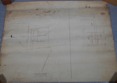
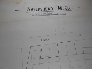 Bendigo Historical Society Inc.
Administrative record - Sheepshead M. Co
Draftsman's drawing Sheepshead Mine Map. Forms part of the Margaret Roberts Collection of mining records.bendigo, margaret roberts, gold, map, mine, sheepshead m.co -
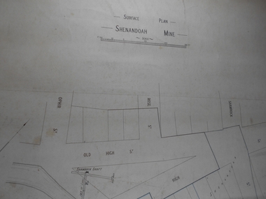 Bendigo Historical Society Inc.
Administrative record - Shenandoah Mine Surface plan
Draftsman's drawing Shenandoah Mine Surface Plan Map. Forms part of the Margaret Roberts Collection of mining records.bendigo, margaret roberts, gold, map, mine, shendandoah mine -
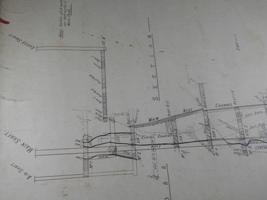
 Bendigo Historical Society Inc.
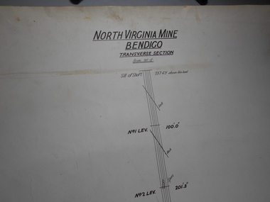
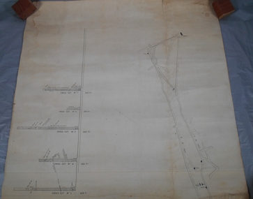
Administrative record - North Virginia Mine Bendigo Transverse Section
Draftsman's drawing North Virginia Mine Transverse Section Map. Forms part of the Margaret Roberts Collection of mining records.bendigo, margaret roberts, gold, map, mine, north virginia mine bendigo -
 Bendigo Historical Society Inc.
Administrative record - Lightning Hill Coy
Draftsman's drawing Lightning Hill Coy Map. Forms part of the Margaret Roberts Collection of mining records.bendigo, margaret roberts, gold, map, mine, lightning hill coy -
 Bendigo Historical Society Inc.
Administrative record - Lightning Hill Coy
Draftsman's drawing Lightning Hill Coy Map. Forms part of the Margaret Roberts Collection of mining records.bendigo, margaret roberts, gold, map, mine, lightning hill coy -
 Bendigo Historical Society Inc.
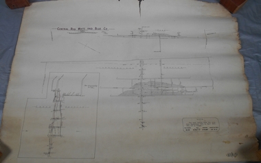
Administrative record - Central Red White and Blue Mine
Draftsman's drawing Central Red, White, and Blue Mine Map. Forms part of the Margaret Roberts Collection of mining records.bendigo, margaret roberts, gold, map, mine, central red white and blue -
 Bendigo Historical Society Inc.
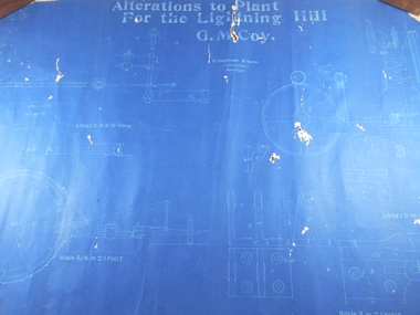
Administrative record - Lightning Hill Coy
Draftsman's drawing Alterations to Lightning Hill Coy plan Map. Forms part of the Margaret Roberts Collection of mining records.bendigo, margaret roberts, gold, map, mine, lightning hill coy -
 Bendigo Historical Society Inc.
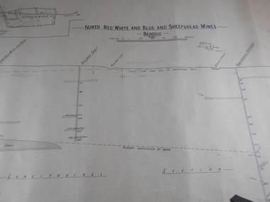
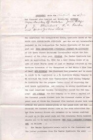
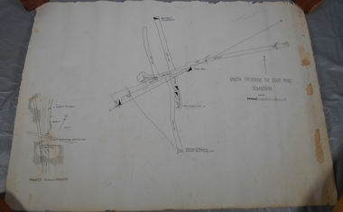
Administrative record - North Red White and Blue and Sheepshead Mine
Draftsman's drawing Central Red, White, and Blue and Sheepshead Mine Map. Forms part of the Margaret Roberts Collection of mining records.Handwritten on plan, Warden's Camp Bendigo Exhibit, Apportion for Forfeiture 8.8.10 (1910) Notes in pencil of measurementsbendigo, margaret roberts, gold, map, mine, north red white blue and sheepshead -
 Bendigo Historical Society Inc.
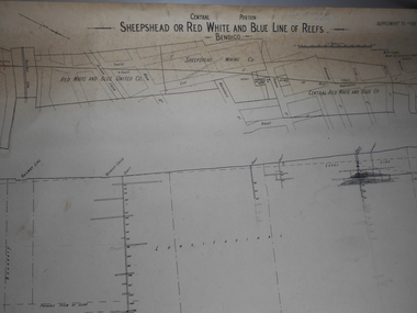
Administrative record - Sheepshead or Red White and Blue Mine
Draftsman's drawing Sheepshead or Red White and Blue Mine Map. Forms part of the Margaret Roberts Collection of mining records. Notes in pencil bendigo, margaret roberts, gold, map, mine, sheepshead or red white and blue reef -
 Bendigo Historical Society Inc.
Document - MCCOLL, RANKIN AND STANISTREET COLLECTION: NEW STAR GOLD MINE HARRIETVILLE NL, SOUTH BLUE CONSOLIDATED SYNDICATE
McColl Rankin & Stanistreet, New Star Gold Mine Harrietville NL. Collection of documents in envelope. a/ Agreement with the unregistered mining syndicate South Blue Consolidated Syndicate and Gold Exploration (Victoria) Co ML application No. 9982 for a Gold Mining Lease of land at Bendigo on Southern Extension of the Sheepshead or Red White & Blue Line of Reef. Dated: 17/6/1932. Signatures: James Phillips, Stanistreet, J M Leed, C J Michelsen, Jardine?? MacKay. 2 pages. b/ Harry Raymond Johnson & Ellis Douglas McDonnel Doyle on behalf of a No Liability Company to be formed, application for Gold Mining Lease NO. 7514 (Beechworth). Vendors are taking steps to a Company to be entitled New Star Gold Mine Harrietville. Signed: ??, E? McDoyle, ??, McColl Rankin & Stanistreet, ?? Dated:1/5/19/33. 2 pages. c/ Indenture between Ellis Douglas McDonnell Doyle, Harry Raymond Johnson and New Star Gold Mine Harrietville NL the company was formed on 27/6/1933 registered and incorporated. Dated 28/6/1933. Signed: Ke? E D M Doyle, Murphy, Mary R Johnson, J Nicolsen, G? Stanistreet. 2 pages. d/ Memo attached to 2-page letter. Re: adjustment of number of shares for Mr. King. Letter acknowledging receipt of paid shares. Dated 25/7/1933. Signed C B King,?? Page 2 lists brokerage etc. for shares. Dated 11/7/1933. e/ Memo & 3-page letter. Memo re surveyor for Dargo. Allotted shares exceeds available shares. Letter: To Wonnangatta Gold Reefs Syndicate regarding purchase of lease hold property in Mining District of Gippsland. Dated 28/6/1934. Signed ?? Page 2, Balance of monies advanced from R A Rankin. Page 3, costs Re Golden Butterfly Mine. f/ Agreement to lease property in Mining District of Gippsland Mining Lease No's 5187 & 5195 Black Snake Creek Dargo, blue print map of Mine included of No.5187. Dated 28/6/1934. Signed: Keohan?, ??, G ?, Geo Kingsley, Stanistreet. 4 pages. g/ An option to purchase certain Applications for Gold Mining Leases. Date: 28/6/34. Signitures: ? M Neill, ??, G ?, J Nichelsen, Stanistreet. 2 Pages.bendigo, gold mining, south blue consolidated, mccoll rankin & stanistreet -
 Bendigo Historical Society Inc.
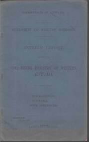
Document - MCCOLL, RANKIN AND STANISTREET COLLECTION: GOLD MINING INDUSTRY OF WESTERN AUSTRALIA, KALGOORLIE, 11th. May 1927
Document: McColl, Rankin & Stanistreet, book 'Interim Report relating to the Gold Mining Industry of Western Australia., Kalgoorlie, Gwalia. Blue cover, 39 pages with maps, graphs.Commonwealth of Australiaorganization, mining, mccoll, rankin & stanistreet, gold mining, western australia. -
 Bendigo Historical Society Inc.
Map - GOLDEN SQUARE GEOLOGICAL SURVEY, 1992
BHS CollectionGolden Square Geological Survey of Goldfields Coloured map.Dept of manufacturing and Industry Development.bendigo, gold mining, geological survey -
Bendigo Historical Society Inc.
Map - PLAN OF VICTORIA HILL AREA, 1971
BHS CollectionBendigo Historical Society feature Plan of the Victoria Hill area. Printed on Paper and laminated. B & W. Compiled by AHG Survey Regiment.CMF Increment May 1971bendigo, gold mining, victoria hill -
Bendigo Historical Society Inc.
Map - PLAN OF VICTORIA HILL AREA, 1971
BHS CollectionBendigo Historical Society feature Plan of the Victoria Hill area. Printed on Paper. B & W. Compiled by AHG Survey Regiment.CMF Increment May 1971bendigo, gold mining, victoria hill -
Bendigo Historical Society Inc.
Map - PLAN OF VICTORIA HILL AREA, 1971
BHS CollectionBendigo Historical Society feature Plan of the Victoria Hill area. Printed on Acetate. B & W. Compiled by AHG Survey Regiment.CMF Increment May 1971bendigo, gold mining, victoria hill -
Bendigo Historical Society Inc.
Map - SANDHURST GOLDFIELDS MAP, 1873
... BHS Collection BENDIGO Gold mining sandhurst goldfields ...BHS CollectionTopographical map of the Sandhurst Goldfilelds. Surveyed by R Brough. May 1873 Coloured map.bendigo, gold mining, sandhurst goldfields -
 Melbourne Tram Museum
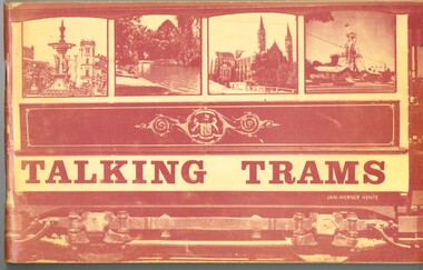
Book, Jan-Werner Hente, "Talking Trams", 1973
Ninety six page book stapled with a heavy card cover, saddle stapled, printed on matt paper, titled "Talking Trams" and written by Jan-Werner Hente. Has a number of pages of light manila colour paper stock printed with a sepia ink. Many black and white photographs. Major Sections include: Pages 7 - 24 - text as if on a "Talking Tram" tram tour of the Bendigo Trust tram., with relevant photographs. Pages 26 - 47 - details briefly the history of each tramcar in the fleet at the time and some scrapped trams. Pages 48 - 49 - map of the route with reference points. Pages 52 - 69 - "If only all trams could talk" - the story of the trams in Bendigo and its mining history, including horse, battery, steam and electric trams, Victorian Railways impact and some of the personalities of the Bendigo Tramways. Pages 70 - 92 - the SEC era and closure and the early Bendigo Trust days Pages 93 - 96 - provides a rolling stock listing - all Bendigo trams. Has a Corrigenda sheet glued to the inside of the front cover.The Corrigenda has a blue tick and "1-10" in the top right hand corner of the first page.trams, tramways, bendigo trust, bendigo, secv, tourist trams -
 Melbourne Tram Museum
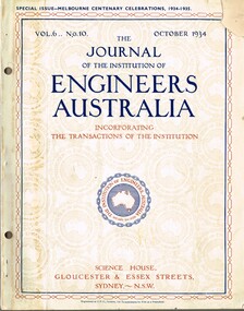
Magazine, Institute of Engineers Australia (IEAust), Journal of the Institution of Engineers Australia" - Vol 6, No. 10, Oct. 1934, "Metropolitan and Provincial Tramways", Oct. 1934
Journal or magazine - stapled pages approx. 100 printed on semi gloss paper, with glue outside cover, titled Journal of the Institution of Engineers Australia" - Vol 6, No. 10, Oct. 1934 - Special issue - Melbourne Centenary Celebrations 1934 - 1935. Contains transactions of radio frequency, institution and related activities, and 100 years of Engineering in Victoria. These include maps of Victoria and Melbourne, Engineering Education (Kernot), Metropolitan Roads and Bridges by J. Noble Anderson City Engineer of Richmond, Country Roads and Bridges, Railway Development (VR), Metropolitan and Provincial Tramways (Strickland and Russell), Port of Melbourne, Outer ports, air transport, water supply, sewerage and drainage, gas industry, electricity supply, communications (telephone and telegraph), industrial development and mining. Has ads for British Insulated cables, Thompsons Engineer, Goodyear, GEC - British General Electric, Associated General electric, Vickers and many other companies. Photocopy of article from the Bob Lilburn collection.trams, tramways, centenary, victoria, tramways, railways, secv, mmtb, cable trams -
 Bendigo Historical Society Inc.
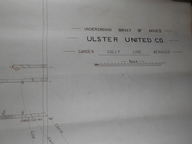
Administrative record - Ulster United Co
Draftsman's drawing Underground Survey of Mines Ulster United Co. Garden Gully Line Bendigo Map. Forms part of the Margaret Roberts Collection of mining records.bendigo, margaret roberts, gold, map, mine, ulster united co -
 Bendigo Historical Society Inc.
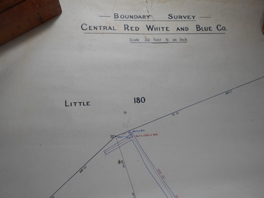
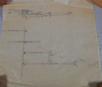
Administrative record - Central Red White and Blue Mine Map
Draftsman's drawing Boundary Survey of Central Red White and Blue Co Map. Handwritten signature of Garnet G Buich, Licensed Mining Surveyor Forms part of the Margaret Roberts Collection of mining records.bendigo, margaret roberts, gold, map, mine, central red white and blue -
 Bendigo Historical Society Inc.
Administrative record - Confidence Cornish Kocks & Windmill Hill
Draftsman's drawing Confidence Cornish Kocks & Windmill Hill Long and Transverse Sections Forms part of the Margaret Roberts Collection of mining records.bendigo, margaret roberts, gold, map, mine, confidence cornish kocks & windmill hill -
 Bendigo Historical Society Inc.
Document - RALH BIRRELL COLLECTION: OLD MINING SITES WHITE HILLS, Dr. Ralph Birrell (now deceased)
4-page typed document, prepared by Dr. Ralph Birrell, on the significance of the former mining sites on the White Hills. Document describes the 'area adjacent to the old Railway Workshops as shown on attached map'. A further addition (slip of paper, typed) to the paper describes the location of the Whiter Hills of White Hills: 1st White Hill is east of Lake Weeroona The 2nd and 3rd White Hills are around Strickland Road, former East Bendigo Primary School, Baden/Powell Streets The 4th and 5th White Hills are east of Napier and Grace Street The 6th White Hill is east of Plumridge Street The 7th White Hill is east of Bosquet Street. -
 Bendigo Historical Society Inc.
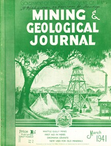
Book - MINING & GEOLOGICAL JOURNAL VOL.2, NO 4, 1941
Mining & Geological Journal, March 1941, Vol.2, No.4. Published by Department of Mines Victoria, 136 pages of Mine Reports, articles on mines, photographs, illustrations, maps & advertisements. Name on cover A.Richardson 29 Harrison St Bendigo.Dept of Mines Victoriagold mines, mining, mining - mines - mining equipment, axedale - fletchers mine. -
 Bendigo Historical Society Inc.
Administrative record - Central Red White and Blue Company Mine map
Draftsman's drawing of Central Red, White and Blue Mine. Printed by Troedel & Cooper Pty Ltd, Surveyor Mr. H. Cumby, Bendigo April 1913 Forms part of the Margaret Roberts Collection of mining records.bendigo, margaret roberts, gold, central red white and blue gold mine, map -
 Bendigo Historical Society Inc.
Administrative record - South Frederick The Great Mine, Sebastian, Mine map
Draftsman's drawing of South Frederick The Great Mine, Sebastian. Forms part of the Margaret Roberts Collection of mining records.Pencil markings additions to mapbendigo, margaret roberts, gold, map, south frederick the great mine -
 Bendigo Historical Society Inc.
Administrative record - South Frederick The Great Mine, Sebastian, Mine map
Draftsman's drawing of South Frederick The Great Mine, Sebastian. Transverse and longitudinal Plan Forms part of the Margaret Roberts Collection of mining records.bendigo, margaret roberts, gold, map, south frederick the great mine -
 Bendigo Historical Society Inc.
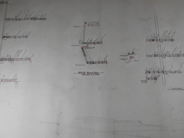
Administrative record - Mine Map
Draftsman's drawing Mine Map. Additional pencil markings. Forms part of the Margaret Roberts Collection of mining records.bendigo, margaret roberts, gold, map, mine -
 Bendigo Historical Society Inc.
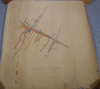
Administrative record - Lansell's Concord Mine Map
Draftsman's drawing Lansells Concord Mine Map. Additional pencil markings for legend Forms part of the Margaret Roberts Collection of mining records.bendigo, margaret roberts, gold, map, mine, lansell's concord