Showing 1182 items matching "municipality"
-
 Greensborough Historical Society
Map, Melbourne and Metropolitan Board of Works. Survey Division, MMBW, Yarra 2500 / 11.22. Bundoora, 1979_01
Melbourne and Metropolitan Board of Works. Yarra 2500 [base map] 11-22. Bundoora. Parish of Keelbundoora 2856, Municipalities of Diamond Valley 257 and Whittlesea 239. Prominent streets include: Greenhills Road, Cabernet Crescent and Plenty Road. Includes Parade College (Christian Brothers) and "proposed future freeway" (now Metropolitan Ring Road)MMBW Map in 1:2500 [scale] series. Cream parchment with green tape reinforcing on edges and punched holes on left edge.mmbw, melbourne and metropolitan board of works, shire of diamond valley, bundoora - maps -
 Greensborough Historical Society
Map, Melbourne and Metropolitan Board of Works. Survey Division, MMBW, Yarra 2500 / 15.21. Eltham North, 1979_08
Melbourne and Metropolitan Board of Works. Yarra 2500 [base map] 15.21. Eltham North. Parish of Nillumbik 3310. Municipalities of Diamond Valley 257 and Eltham 238. Prominent streets include: Progress Road, Glen Park Road and Zig Zag Road. Features include the Diamond Creek, Eltham Council Pound and Eltham North Reserve.MMBW Map in 1:2500 [scale] series. Cream parchment with green tape reinforcing on edges and punched holes on left edge.mmbw, melbourne and metropolitan board of works, shire of diamond valley, nillumbik, eltham - maps -
 Greensborough Historical Society
Map, Melbourne and Metropolitan Board of Works. Survey Division, MMBW, Yarra 2500 / 14.23. Diamond Creek, Sutherland Homes, 1979_05
Melbourne and Metropolitan Board of Works. Yarra 2500 [base map] 14.23. Diamond Creek, Sutherland Homes. Parish of Morang 3183 and Nillumbik 3310. Municipality of Diamond Valley 257. Prominent streets Aqueduct Road, Diamond Creek Road, Yan Yean Road and McLaughlans Lane. Features include the abandoned Maroondah aqueduct and Sutherland Cottages.MMBW Map in 1:2500 [scale] series. Cream parchment with green tape reinforcing on edges and punched holes on left edge.mmbw, melbourne and metropolitan board of works, shire of diamond valley, plenty - maps, sutherland homes, maroondah aqueduct -
 Greensborough Historical Society
Map, Melbourne and Metropolitan Board of Works. Survey Division, MMBW, Yarra 2500 / 13.28. Mernda, Wilton Vale, 1977_08
Melbourne and Metropolitan Board of Works. Yarra 2500 [base map] 13.28. Mernda, Wilton Vale. Municipality of Diamond Valley 257 and Whittlesea 239. Prominent streets: Wilton Vale Road. Features include Yan Yean Pipe Track and SEC Transmission Lines. The abandoned rail line (old Whittlesea line) is in the top left corner.MMBW Map in 1:2500 [scale] series. Cream parchment with green tape reinforcing on edges and punched holes on left edge.mmbw, melbourne and metropolitan board of works, shire of diamond valley, mernda - maps -
 Greensborough Historical Society
Map, Melbourne and Metropolitan Board of Works. Survey Division, MMBW, Yarra 2500 / 15.24. Diamond Creek, Grassy Flat Road, 1978_02
Melbourne and Metropolitan Board of Works. Yarra 2500 [base map] 15.24. Diamond Creek, Grassy Flat Road. Parish of Nillumbik 3310. Municipality of Diamond Valley 257. Prominent streets include: Everleigh Drive, Broad Gully Road and Clyde Street. Features include the Diamond Creek, Nillumbik Park and Diamond Creek Reservoir.MMBW Map in 1:2500 [scale] series. Cream parchment with green tape reinforcing on edges and punched holes on left edge.mmbw, melbourne and metropolitan board of works, diamond creek - maps, shire of diamond valley -
 Bendigo Historical Society Inc.
Document - MINING REPORTS - KING OF PRUSSIA MINE
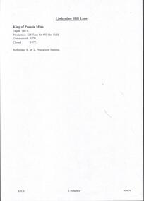
KING OF PRUSSIA MINE WHIPSTICK ROAD EAGLEHAWK NORTH, GREATER BENDIGO CITY Place ID 8444 Location WHIPSTICK ROAD EAGLEHAWK NORTH, GREATER BENDIGO CITY Municipality GREATER BENDIGO CITY Heritage Listing Victorian Heritage Inventory Level of significance Heritage Inventory Site Heritage Inventory (HI) Number H7724-0141Brief handwritten notes by Albert Richardson, with typed copy of same, on the King of Prussia Mine on the Lightning Hill Line. Notes give the depth, crushings, gold yield, commenced 1876 and closed 1877.gold, mining reports, mining reports, kinf of prussia mine, b m l production statistics -
 Ringwood and District Historical Society
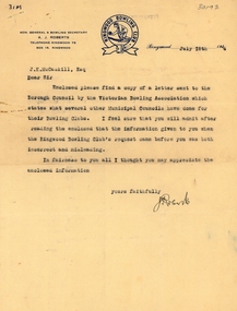
Letter, Ringwood Bowls Club- Letter to J.K. McCaskill, Ringwood Councillor, dated 18th July, 1944, with attached letter from Victorian Bowling Association to Ringwood Borough Council
Copy of typed letters. Letter to Council signed by Hon. General & Bowling Secretary A.J. Roberts, correcting some misinformation given to Council from Ringwood Bowling Club regarding the availability of a site for the proposed Club. The attached letter from the Victorian Bowling Association to the Borough Council suggests that provision be made in recreation areas for sites for bowling greens in municipalities throughout Victoria. -
 Kew Historical Society Inc
Plan - Subdivision Plan, J R Mathers & McMillan, Normanby Estate, c.1913
The Kew Historical Society's map collection includes a substantial number of real estate subdivision plans, mainly of Kew but also of surrounding suburbs in Melbourne. Most of the subdivision plans date from the 1920s and 1930s when the districts old homes and local farmland were being split up to accommodate residential growth in the postwar period. These early plans were assembled by a local firm, Jas R Mather & McMillan, which had an office in Cotham Road. Many of the plans, and sometimes photos, were annotated by the agents.Subdivision plans are historically important documents used as evidence for the growth of suburbs in Australia. They frequently provide information about when the land was sold as well as evidence relating to surveyors and real estate and financial agents. The numerous subdivision plans in the Kew Historical Society's collection represent working documents, ranging from the initial sketches made in planning a subdivision to printed plans on which auctioneers or agents listed the prices for which individual lots were sold. In a number of cases, the reverse of a subdivision plan in the collection includes a photograph of a house that was also for sale by the agent. These photographs provide significant heritage information relating house design and decoration, fencing and household gardens.The photograph may also be aesthetically significant depending on the importance of the photographic atelier.The Normanby Estate, which was adjacent to Normanby Road, Kew East, included thirty-one lots for sale. Streets on the subdivision plan include Adeney Avenue, Park Hill Road, Normanby Road, Weir Street and Wharton Street. Cotham Road and its tramway are shown nearby. The plan is interesting as it shows Wharton Street, named after the architect and town planner George Wharton, who was the first chairman of the Municipality of Kew. The street was to later be renamed Cecil Street. Also shown are proposed ‘Municipal Gardens’ where Parkhill Drive is now located."D" in top left corner. Stamped auctioneers contact details: "Jas. R. Mathers & Son & McMillan / Auctioneer & Land Salesmen, / 271 Collins Street / Melbourne" and Jas. R. Mathers / Estate & Financial Agent / Cotham Road / Kew".weir street - kew, wharton street - kew, normanby road - kew, cotham road - kew, municipal gardens - kew, park hill parkhill road - kew, braemar - kew, subdivision plans - kew -
 Kew Historical Society Inc
Plan - Subdivision Plan, Normanby Estate, East Kew, 1913
Pru Sanderson, in her groundbreaking ‘City of Kew Urban Conservation Study : Volume 2 - Development History’ (1988), summarised the periods of urban development and subdivisions of land in Kew. The periods that she identified included 1845-1880, 1880-1893, 1893-1921, 1921-1933, 1933-1943, and Post-War Development. These periods were selected as they represented periods of rapid growth or decline in urban development. An obvious starting point for Sanderson’s groupings involved population growth and the associated economic cycles. These cycles also highlighted urban expansion onto land that was predominantly rural, although in other cases it represented the decline and breakup of large estates. A number of the plans in the Kew Historical Society’s collection can also be found in other collections, such as those of the State Library of Victoria and the Boroondara Library Service. A number are however unique to the collection.The Kew Historical Society collection includes almost 100 subdivision plans pertaining to suburbs of the City of Melbourne. Most of these are of Kew, Kew East or Studley Park, although a smaller number are plans of Camberwell, Deepdene, Balwyn and Hawthorn. It is believed that the majority of the plans were gifted to the Society by persons connected with the real estate firm - J. R. Mathers and McMillan, 136 Cotham Road, Kew. The Plans in the collection are rarely in pristine form, being working plans on which the agent would write notes and record lots sold and the prices of these. The subdivision plans are historically significant examples of the growth of urban Melbourne from the beginning of the 20th Century up until the 1980s. A number of the plans are double-sided and often include a photograph on the reverse. The Normanby Estate, which was adjacent to Normanby Road, Kew East, included thirty-one lots for sale. Streets on the subdivision plan include Adeney Avenue, Park Hill Road, Normanby Road, Weir Street and Wharton Street. Cotham Road and its tramway are shown nearby. The plan is interesting as it shows Wharton Street, named after the architect and town planner George Wharton, who was the first chairman of the Municipality of Kew. The street was to later be renamed Cecil Street. Also shown are proposed ‘Municipal Gardens’ where Parkhill Drive is now located.subdivision plans - kew, normanby estate -
 Kew Historical Society Inc
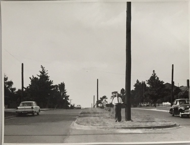
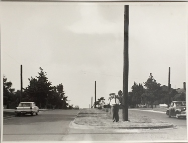
Photograph, Stuart Tompkins Studio, Electricity Supply Poles, Burke Road, Kew, 1965
Research provided by Stuart Tompkins Studio, Box Hill, into alternatives for median strip street lighting to be used in Burke Road, Kew. The photographers identified variants in different suburbs appropriate to Kew's needs.The series from which the photograph is drawn provides a snapshot by a commercial photographic studio of each named vicinity in 1965 as well as providing examples of public works infrastructure being commissioned by local government in the 1960s. The photos originally formed part of the Engineering Department's files in the City of Kew before being donated to the kew Historical Society.Electricity Supply Poles, Burke Road, Kew, 1965. This photograph of Burke Road, Kew was taken just north of Kilby and Doncaster Roads looking north. Stuart Tompkins Studio provided the photograph for the Kew City Council. In the photograph are a number of electricity supply poles that have been erected in the median strip, in addition to some new poles on each footpath. The nearest wooden pole is stated to be 13.5″ in diameter. The electricity poles in Burke Road required Kew Council to investigate comparable designs in other Melbourne municipalities. [There are three copies of this photograph in the Collection.] Typed inscription on reverse: "Electricity Supply Poles. Photographed for Kew City Council 8/2/65. No.5 Burke Road - Kew, just north of Kilby and Doncaster Roads looking north. Some of seven poles already erected in median strip. Shows also some new poles erected on each footpath. Nearest wooden pole 13 1/2" dia." Studio stamp: "Stuart Tompkins Studio. 547 Station Street, Box Hill. WX1439."stuart tompkins studio, street lighting, south road (moorabin) 1965 -
 Kew Historical Society Inc
Photograph, Stuart Tompkins Studio, Electricity Supply Poles, Burke Road, Kew, 1965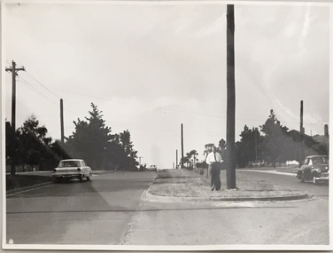
Research provided by Stuart Tompkins Studio, Box Hill, into alternatives for median strip street lighting to be used in Burke Road, Kew. The photographers identified variants in different suburbs appropriate to Kew's needs.The series from which the photograph is drawn provides a snapshot by a commercial photographic studio of each named vicinity in 1965 as well as providing examples of public works infrastructure being commissioned by local government in the 1960s. The photos originally formed part of the Engineering Department's files in the City of Kew before being donated to the kew Historical Society.Electricity Supply Poles, Burke Road, Kew, 1965. This photograph of Burke Road, Kew was taken just north of Kilby and Doncaster Roads looking north. Stuart Tompkins Studio provided the photograph for the Kew City Council. In the photograph are a number of electricity supply poles that have been erected in the median strip, in addition to some new poles on each footpath. The nearest wooden pole is stated to be 13.5″ in diameter. The electricity poles in Burke Road required Kew Council to investigate comparable designs in other Melbourne municipalities. [There are three copies of this photograph in the Collection.] Typed inscription on reverse: "Electricity Supply Poles. Photographed for Kew City Council 8/2/65. No.5 Burke Road - Kew, just north of Kilby and Doncaster Roads looking north. Some of seven poles already erected in median strip. Shows also some new poles erected on each footpath. Nearest wooden pole 13 1/2" dia." Studio stamp: "Stuart Tompkins Studio. 547 Station Street, Box Hill. WX1439."stuart tompkins studio, street lighting, south road (moorabin) 1965 -
 Kew Historical Society Inc
Map, MMBW, MMBW Town of Kew, 1910-21
The Melbourne and Metropolitan Board of Works (MMBW) was established by an act of the Victorian Parliament in 1890 to prepare for and to implement a sewerage and water reticulation system across what was then inner Melbourne, its surrounding and middle distance suburbs, including Kew. The MMBW was disbanded in 1991.The map collection of the Kew Historical Society has at its core the historic maps assembled and originally stored in the City Engineer's Department of the City of Kew. These include maps in a number of scales. The vast majority of maps were produced by the MMBW in the first two decades of the twentieth century, and are solid working maps, backed by linen for durability. These maps are historically significant to Kew, the City of Boroondara and to the history of the development of state utilities in Victoria. A number of the Kew maps have additional details added by former municipal officers, including the levels reached by various floods. As these were working documents, information was added to them long after the period of their initial production and distribution.Early map of the Town of Kew, created after 1910, at a scale 440 ft to 1 inch. The 'assembled' map by the City of Kew Engineer's Department includes scaled down copies of The Melbourne and Metropolitan Board of Works maps, Nos. 39, 40, 64, 65, 66, 67, 68, and 117. The map covers the entirety of the Town of Kew, bordered on its north and west by the River Yarra, by Burke Road in the East and Barkers Road in the south. The map shows the extent of urban development by that time, prominent institutions and the outlines of built structures in the municipality. TOWN OF KEW / SCALE 400 FEET TO 1 INCHmelbourne & metropolitan board of works, mmbw maps, mmbw plans, town of kew, cartography -
 Kew Historical Society Inc
Map, MMBW, MMBW Plan No.40 Collingwood & Kew, 1900-1910
The Melbourne and Metropolitan Board of Works (MMBW) was established by an act of the Victorian Parliament in 1890 to prepare for and to implement a sewerage and water reticulation system across what was then inner Melbourne, its surrounding and middle distance suburbs, including Kew. The MMBW was disbanded in 1991.The map collection of the Kew Historical Society has at its core the historic maps assembled and originally stored in the City Engineer's Department of the City of Kew. These include maps in a number of scales. The vast majority of maps were produced by the MMBW in the first two decades of the twentieth century, and are solid working maps, backed by linen for durability. These maps are historically significant to Kew, the City of Boroondara and to the history of the development of state utilities in Victoria. A number of the Kew maps have additional details added by former municipal officers, including the levels reached by various floods. As these were working documents, information was added to them long after the period of their initial production and distribution.Early map of part of the Borough of Kew, created in the first decade of the twentieth century, at a scale 160 ft to 1 inch. The map covers what was then the south western section of Kew, bordered on its north by Studley Park Road, in the west by Walmer Street and the River Yarra, by High Street South and Princess Street in the East and Barkers Road in the south. The map shows the extent of urban development by that time, prominent institutions and the outlines of built structures in the municipality. Contour lines and historic flood levels were added in ink to the map at a later stage.MELBOURNE AND METROPOLITAN BOARD OF WORKS / PLAN NO. 40 / COLLINGWOOD & KEWmelbourne & metropolitan board of works, mmbw maps, mmbw plans, borough of kew, cartography -
 Greensborough Historical Society
Map, Melbourne and Metropolitan Board of Works. Survey Division, MMBW, Yarra 2500 / 13.19. Lower Plenty, Montmorency, Yallambie, 1979_02
Melbourne and Metropolitan Board of Works. Yarra 2500 [base map] 13-19. Lower Plenty, Montmorency, Yallambie. Parishes of Keelbundora 2856 and Nillumbik 3310. Municipalities of Heidelberg 228, Diamond Valley 257 and Eltham 238. Prominent streets include: Elder Street, Para Road, and Main Road Lower Plenty. Includes Watsonia Army Barracks.MMBW Map in 1:2500 [scale] series. Cream parchment with green tape reinforcing on edges and punched holes on left edge.mmbw, melbourne and metropolitan board of works, shire of diamond valley, montmorency - maps, yallambie - maps, lower plenty - maps -
 Bayside Gallery - Bayside City Council Art & Heritage Collection
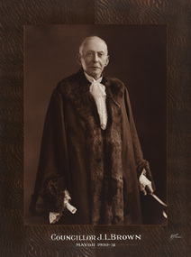
Photograph - sepia photograph, Allan Studio, Councillor J.L. Brown, Mayor of Sandringham 1930-31, c. 1931
James Little Brown (1866-1960) was Mayor of Sandringham in 1930-31.councillor, sandringham, local government, municipality, mayor, portrait, city of sandringham, mayoral robes, jabot, cr. j.l. brown, james little brown, mayor of sandringham -
 Bayside Gallery - Bayside City Council Art & Heritage Collection
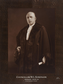
Photograph - sepia photograph, Allan Studio, Councillor W.L. Simpson, Mayor of Sandringham, 1934-35, c. 1935
Councillor Walter Leo Simpson (1884-1946) was Mayor of Sandringham in 1934-35 and 1943-44.councillor, sandringham, local government, municipality, mayor, portrait, city of sandringham, mayoral robes, jabot, cr. w.l. simpson, walter leo simpson, mayor of sandringham -
 Greensborough Historical Society
Map, Melbourne and Metropolitan Board of Works. Survey Division, MMBW, Yarra 2500 / 14.22. St Helena, St Katherine's Church, 1979_08
Melbourne and Metropolitan Board of Works. Yarra 2500 [base map] 14.22. St Helena, St Katherine's Church. Parish of Nillumbik 3310. Municipality of Diamond Valley 257. Prominent streets St Helena Road, Weidlich Road, Yan Yean Road and Allumba Drive. Features include St Katherine's Church of England and the St Helena Secondary College site.MMBW Map in 1:2500 [scale] series. Cream parchment with green tape reinforcing on edges and punched holes on left edge.mmbw, melbourne and metropolitan board of works, shire of diamond valley, st helena - maps, st katherines church st helena -
 Kew Historical Society Inc
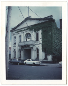
Photograph - Former Kew Town Hall, Walpole Street, 1972
The Municipality of Kew was granted independence in 1860. It was declared a borough in 1863, a town in 1910 and a city in 1921. In 1994, Kew was amalgamated into the new City of Boroondara. In 1960, a new Town Hall in Cotham Road was opened. The Municipal Offices that had remained in the former Town Hall in Walpole Street until it was moved to the new Civic Centre on the corner of Cotham Road and Charles Street in 1972.This is a rare and important colour photograph of the Kew Municipal Offices (former Town Hall) taken on 11/2/1972 in the year that the building was demolished and replaced by a Safeway Supermarket.Colour photographic positive (polaroid) of the front of the (former) Kew Town Hall in Walpole Street between High Street and Malmsbury Street, on the west side where Woolworth's supermarket now stands. The photograph, taken in February 1972, shows the detailing of the Italianate rendered-brick facade, added in the 1880s when the hall was renovated. The earliest building on the site was the Kew Athenaeum Hall (built 1860) which was purchased by Kew Council in 1865. The Town Hall was sold to Woolworth's and subsequently demolished in 1972 when the civic offices were transferred to a new building on the corner of Charles Street and Cotham Road.kew town hall -- walpole street, local government -- kew, town halls -- melbourne (vic.) -
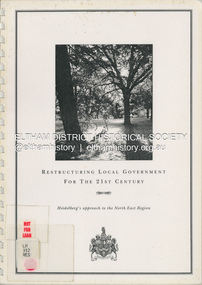 Eltham District Historical Society Inc
Document (Item) - Book, City of Heidelberg, Restructuring Local Government for the 21st Century: Heidelberg's approach to the North East Region, February 1994
The City of Heidelberg's Council first preference is "no change" [to municipal restructure] but if this option is unacceptable, the Council would prefer to form larger municipality/municapilites involving the exisitng City of Heidelberg and the Shires of Diamond Valley and Eltham. This report includes an exective summary, Introduction, A Brief History, Heidelberg and its [municiapl] neighbours now, opportunities for restructure, detailed analysis and preferred structure. Includes fold out maps.This report by the City of Heidleberg is a significant local contribution in the consultation leading to a significant change to local government in Victorian when, in 1994 the Kennett State government restructed local government. The reforms dissolved 201 Councils and created 78 new councils through amalgamations. In suburban Melbourne 53 municipalities were reduced to 26. The City of Heidelberg was amalgamated with parts of the Shire of Eltham and Diamond Valley to become the City of Banyule.annexation, council amalgamation, local government -
 Glen Eira Historical Society
Document - Oakleigh Hall
Photocopy of extract from History of St. Kilda 1931 by John Butler Cooper. Two pages describing history of Oakleigh Hall and its early owners. Also handwritten, brief research by Felicity Campbell dated 13/05/2005 noting the location of Oakleigh Hall in Port Phillip Municipality and typed and handwritten undated, unattributed brief notes listing owners of Oakleigh Hall.kyte ambrose, oakleigh hall, wilson samuel, mansions, orrong road, caulfield, inkerman road, dandenong road, campbell felicity, de graves, michie archibald, hallamore samuel, oxford club, fisher andrew, alma road -
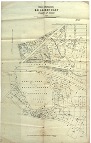 Federation University Historical Collection
Plan, Ballaarat East Town Allotments, 1891, 18/09/1891
Ballarat East was historically a separate municipality than Ballaarat. The streets developed along gold leads and early tracks. The Public Park Botanic Gardens and Recreation Reserve is now Mount Xavier Golf Course, and Ballarat Secondary College Eastern Campus. The section with Bettle's Private Property is now Saint Francis Xavier Primary School. Elford Street now appears to be the continuation of Eureka Street.Plan of Town Allotments for a portion of Ballarat East in the County of Grant. It shows Victoria Street, Clifford Street, Finlay Street, Ryan Street, Bradbury Street, Elford Street, Fussell Street, Jones Street, Park Parade, Ballarat -Geelong Railway, Eureka Street, Ballarat East Public Park Botanic Garden and Recreation Reserve. The only allotment names is Bettle's Private Property. Gift of the Squire Family, 2014ballarat east, ballaarat east, victoria street, ballarat east botanical gardens, richard squire, squire, ryan street, jones street, bradbury street, humffray steet, fussell street, elford street -
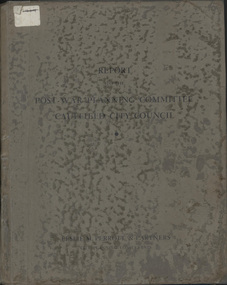 Glen Eira City Council History and Heritage Collection
Book, "Report to the Post War Planning Committee, Caulfield City Council"
The Post War Planning Report was prepared by Leslie M. Perrott & Partners: (City Planning Consultants) and according to the report, it was submitted to the Council of the Municipality of Caulfield through its Special Committee on Post War Planning. The report has no evident date however the introduction text suggests that it was prepared before the end of World War II. The report is the only known extant copy and therefore considered rare. Bound report with grey cover titled: "Report to the Post War Planning Committee Caulfield City Council". Interior pages include x83 pages typed text printed on blue print paper; x3 pages copies of black and white photographs; 10 blueprint plans. 86 pages consistent in size with book cover, 10 x blueprint plans varying dimensions, folded and bound within the report. Printed on white sticker on spine of book "LH 994. 51" and on first page inside "CAULFIELD LIBRARY SERVICE REFERENCE BOOK" and on the verso of this page, another stamp with CAULFIELD LIBRARY SERVICE and LH REF 12/7 hand written in black ink and a 14 digit reference number below this. On the back of the last plan in the book, there is a blue stamp with "REFERENCE BOOK TO BE USED IN THE LIBRARY ONLY". Below this is a black and white barcode with a black line through it and a round, blue sticker beside it. -
 Warrnambool and District Historical Society Inc.
Administrative record (Collection) - Warrnambool City Council Administrative Records, Warrnambool City Council Officers, 1990s
Warrnambool City Council Records collected by a member of a Council Advisory Committee.Collection of Warrnambool City Council records of the 1990sIn folders and archival envelopes in an A3 archival boxTwo A3 archival envelopes containing information on Foreshore etc., five booklets containing reports on City Plans, Council Strategies etc and 15 Reports (Shop Trading, Coastal Wetlands, Foreshore, Landcare etc)warrnambool city council, warrnambool city council strategies and planswarrnambool city council, warrnambool city council strategies and plans -
 Bendigo Historical Society Inc.
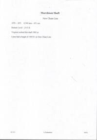
Document - MURCHISON SHAFT
Victorian Heritage Database Report Report generated 03/03/25 MURCHISON SHAFT Location LESTER STREET SAILORS GULLY, GREATER BENDIGO CITY Municipality GREATER BENDIGO CITY Level of significance Heritage Inventory Site Heritage Inventory (HI) Number H7724-0192 Heritage Listing Victorian Heritage Inventory Other Names NEW CHUM REEF, Hermes Number 8493Handwritten notes with typed copy, on the Murchison Shaft on the New Chum Line. 1870 - 1871. 6,7 tons - 651 ozs. Bottom Level - 2315 ft. Virginia worked this shaft 1883 to -. Lease had a length of 1400 ft. on New Chum Line.document, gold, murchison shaft, virginia -
 Melbourne Tram Museum
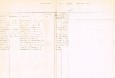
Document - Personal Papers, H. S McComb, "Tramways Proposed but not Authorised", late 1940's?
Set of three documents, hand made in pencil by Mr. McComb. 1 - on ruled double foolscap (folio) paper, titled "Tramways Proposed but not Authorised", listing street, municipality, extent, date of application or special construction scheme and date of report to Parliamentary Committee. List proposals for the cities of St Kilda, Hawthorn, Essendon, Malvern, Camberwell , Coburg and Broadmeadows. 2 - hand written note on quarto paper, re the outcomes or notes on the above proposals. 3 - draft of a sheet prepared, as for 1, "M&MTB General Scheme for Development of Tramways" - columns set out but not usedtrams, tramways, tramways, proposals, st kilda, hawthorn, essendon, malvern, camberwell, coburg, brunswick, general scheme -
 Bendigo Historical Society Inc.
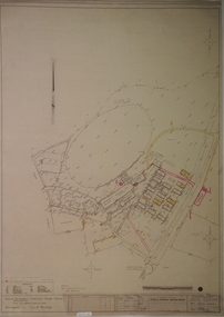
Plan - SANDHURST BOYS CENTRE COLLECTION: PART DETAIL SURVEY
Prepared by the Public Works Department for the Government of Victoria. Client is the Mental Health Department, Municipality is City of Bendigo. Site plan of area bounded by O'Dwyer St and Finn St, North Bendigo. Handwritten note on back - Update of whole centre 10/4/91. Details include: oval, tennis court, grandstand, area is bounded by an un-named watercourse. Also indicated are 14 nissen huts, 2 toilet blocks, 3 weatherboard buildings, 1 galvanised iron building,2 galvanised iron sheds (one new), residence, garage, fowl shed, and a carpark. bendigo, institutions, sandhurst boys centre, sandhurst boys centre site plan; -
 Vision Australia
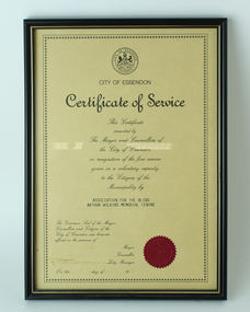
Certificate - Text, Certificate of Service from the City of Essendon to the Arthur Wilkins Memorial Centre, 1993
Certificate awarded to the Arthur Wilkins Day Centre for it's work with the blind and visually impaired people of Essendon, awarded on November 8, 1988.1 certificate of service from the City of EssendonCity of Essendon Certificate of Service This Certificate presented by The Mayor and Councillors of the City of Essendon in recogition of the fine service given in a voluntary capacity to the Citizens of the Municipality by Association for the Blind Arthur Wilkins Memorial Centre. The Common Seal of the Mayor, Councillors and Citizens of the City of Essendon was hereunto affixed in the presence of (signature illegible) Mayor (signature illegible) Councillor (signature illegible) City Manager On this .... day of .... , 19....association for the blind, city of essendon -
 Disability Sport & Recreation Victoria
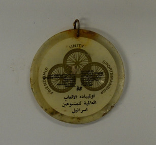
Plastic souvenir, The International Stoke-Mandeville Games for the Paralysed - Israel '68, 1968
The International Stoke-Mandevile Games, held in Tel-Aviv in 1968, were later classified as the third edition of the Paralympics. The International Wheelchair and Amputee Sports (IWAS) World Games (or IWAS World Games) are a multi-sport competition for athletes with a disability, which under the former name of the International Stoke Mandeville Games were the forerunner of the Paralympic Games. The competition has been formerly known as the World Wheelchair and Amputee Games, the Stoke Mandeville Wheelchair Games, the Stoke Mandeville Games, the World Wheelchair Games, and in the 1960s and 1970s was often referred to as the Wheelchair Olympics. The Games were originally held in 1948 by neurologist Sir Ludwig Guttmann, who organized a sporting competition involving World War II veterans with spinal cord injuries at the Stoke Mandeville Hospital rehabilitation facility in Aylesbury, England, taking place concurrently with the first post-war Summer Olympics in London. In 1952, the Netherlands joined in the event, creating the first international sports competition for the disabled. In 1960, the Ninth Stoke Mandeville Games were held in Rome, Italy, following that year's Olympic Games. These are considered to be the first Paralympic Games.[1] The 2012 Paralympic mascot Mandeville was named after Stoke Mandeville Hospital. While the Paralympic Games evolved to include athletes from all disability groups, the Stoke Mandeville games continued to be organized as a multi-sport event for wheelchair athletes. Games were held annually in Aylesbury under the direction of the International Stoke Mandeville Games Federation (ISMGF), which became the International Stoke Mandeville Wheelchair Sports Federation (ISMWSF)..Plastic medallion encasing a paper disc commemorating the 1968 Stoke-Mandeville Games for the Paralysed. Inscriptions (English): Front: Municipalities - Nazareth Elite - Nazareth. Reverse: The International Stoke-Mandeville Games for the Paralysed - Israel '68. Friendship - Unity - Sportsmanship. On both sides of the medallions there are what are likely to be the equivalent Hebrew and Arabic translations. Images induces Front: Logos of unknown organisations. Reverse: Logo for the 1968 Paralympics, showing three interlocking wheels to represent their values: friendship, unity and sportsmanship 1968 paralympics, 1968 stoke-mandeville-games, 1968 tel-aviv paralympics -
 Warrnambool and District Historical Society Inc.
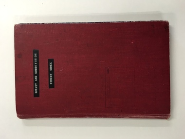
Register, Survey & subdivision street index, 1930s
This is a book with the City of Warrnambool surveys and subdivisions listed under the street names. It covers the period from 1938 to 1975. The information is listed under the headings of plan number, street name, section, allotment, date and remarks. The information contained therein would now be held as electronic data in the Council Records Department. Warrnambool, founded in 1847, became a municipality in 1856, a Borough in 1863, a Town in 1883 and a City in 1918. This book is of considerable interest because it lists Warrnambool streets from 1938 to 1975 and gives details of the subdivisions and surveys during that time. It will be very useful for researchers. This is a foolscap-size hard-cover book with a red cover with a mottled-blue pattern paper inside the covers. It has 95 pages with ruled red and blue lines. It has a handwritten alphabet index throughout the pages. The contents are handwritten in blue, green and black ink. The inside binding has been mended with adhesive tape and one page is loose. The book lists subdivisions in the City of Warrnambool under the heading of the street names and covers 1938 to 1975. The cover is somewhat grubby.Front Cover (in plastic tape): ‘Survey and Subdivision. Street Index’warrnambool city council, warrnambool streets and subdivisions