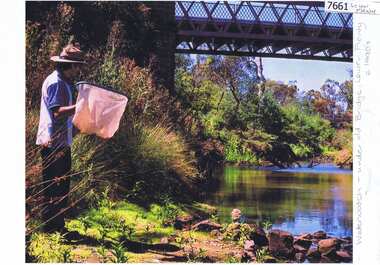
Showing 16883 items matching "plenty-river"
-
 Eltham District Historical Society Inc
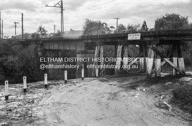
Photograph - Negative, Russell Yeoman, Railway Bridge across Plenty River near Railway Road, Briar Hill, Vic, c.1970
Part of a slide show presentation "Bridges & Waterways of the Shire" by Russell Yeoman to the 13 September 1989 Society meeting. The presentation included slides of historic photos from the Shire of Eltham Pioneers collections as well as several recent views.Roll of 35mm black and white negative film, 4 of 7 stripsIlford HP4bridge, greensborough, para road, plenty river, railway bridge -
 Eltham District Historical Society Inc
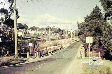
Photograph, Russell Yeoman, Para Road (Carter Street) Bridge over the Plenty River, Briar Hill, Vic, 1970s
Digital file only; created from original colour positive slide transparencystreets, para road, carter street, bridge, railway line, russell yeoman collection -
 Kew Historical Society Inc
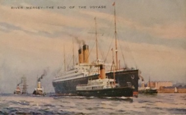
Postcard, Valentine's Series, River Mersey - The End of the Voyage, c.1928
Collection of thirty-nine postcards donated by Jillian Rigby which had been owned by her grandparents, George and Edith Weir, who from c.1917 lived at 84 Princess Street, Kew. The mostly 'mint' postcards were purchased in Victoria and while travelling overseas. The sole dated postcard is dated from 1929. The postcards are numbered sequentially from 2017.0058.01-39. The remainder of the collection donated by Jill Rigby which was once owned by the Weirs of Broken Hill and Kew consist of costumes, costume accessories, photographs, and documents.The postcards in the Weir collection, especially those purchased on a trip or trips to the mother country, i.e. United Kingdom, represent a representative sample of sites that were considered significant to those Australians undertaking a reverse grand tour by member of the erstwhile colonies. Those postcards which are early views of Melbourne must have been produced commercially for some decades from the early part of the 20th century.River Mersey - The End of the Voyage. One of a set of three [originally six] 'High Class Postcards of Memories of the Mersey, Beautifully Reproduced in Nature Colours', in their original brown envelope. The postcard was probably purchased by George and Edith Weir on a trip to England and Scotland, circa 1928."River Mersey - The End of the Voyage"postcards, george and edith weir, river mersey, postcards -- uk, weir collection -
 Kew Historical Society Inc
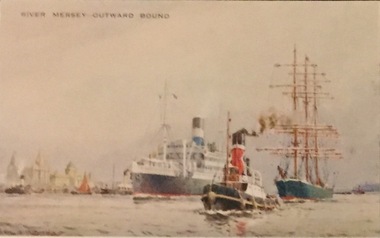
Postcard, Valentine's Series, River Mersey - Outward Bound, c.1928
Collection of thirty-nine postcards donated by Jillian Rigby which had been owned by her grandparents, George and Edith Weir, who from c.1917 lived at 84 Princess Street, Kew. The mostly 'mint' postcards were purchased in Victoria and while travelling overseas. The sole dated postcard is dated from 1929. The postcards are numbered sequentially from 2017.0058.01-39. The remainder of the collection donated by Jill Rigby which was once owned by the Weirs of Broken Hill and Kew consist of costumes, costume accessories, photographs, and documents.The postcards in the Weir collection, especially those purchased on a trip or trips to the mother country, i.e. United Kingdom, represent a representative sample of sites that were considered significant to those Australians undertaking a reverse grand tour by member of the erstwhile colonies. Those postcards which are early views of Melbourne must have been produced commercially for some decades from the early part of the 20th century.River Mersey - Outward Bound. One of a set of three [originally six] 'High Class Postcards of Memories of the Mersey, Beautifully Reproduced in Nature Colours', in their original brown envelope. The postcard was probably purchased by George and Edith Weir on a trip to England and Scotland, circa 1928."River Mersey - Outward Bound"postcards, george and edith weir, river mersey, postcards -- uk, weir collection -
 Eltham District Historical Society Inc
Negative - Photograph, J.A. McDonald, Eltham-Yarra Glen Road, Lower Plenty footbridge, Sep. 1955
Tony Carberry and J. Jolly The Eltham-Yarra Glen Road as designated originated at the Shire of Eltham boundary at the Plenty River. West of the river the road was known as the Heidelberg-Eltham Road. The section from the Plenty River is now known as Lower Plenty Road which becomes Main Road. The footbridge no longer exists but was originally sited to the south, adjacent to the old Lower Plenty Bridge, now part of the Plenty River Trail. Record of various Shire of Eltham infrastructure works undertaken during the period of 1952-1962 involving bridge and road reconstruction projects, sometimes with Eltham Shire Council Project Reference numbers quoted. It was during this period that a number of significant improvements were made to roads and new bridges constructed within the shire that remain in place as of present day (2022). In many situations, the photos provide a tangible visible record of infrastructure that existed throughout the early days of the Shire. The album was put together by or under the direction of the Shire Engineer, J.A. McDonald.1955-09, eltham-yarra glen road, lower plenty footbridge, j. jolly, lower plenty, lower plenty bridge, lower plenty road, main road, plenty river trail, tony carberry, bridge construction, infrastructure, shire of eltham -
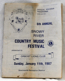 Orbost & District Historical Society
souvenir program, 1987
The annual Snowy River Country Music Festival was organised by the Lions Club of Orbost and held at the Newmerella Recreation Reserve. The 6th event was held on Sunday, Jan 11 1987.This program is significant in that it is a souvenir of a local event which no longer takes place.An official souvenir program for the 6th annual Snowy River Country Music Festival, 1987. B/W print.snowy-river-country-music-festival program souvenir -
 Eltham District Historical Society Inc
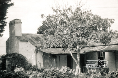
Photograph, House, 'Rosehill', Lower Plenty, 1968, 1968
Three black and white photographs of views of 'Rosehill' at Lower Plenty, 1968rosehill, bonds road, lower plenty, houses, henry stooke -
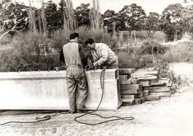
 Eltham District Historical Society Inc
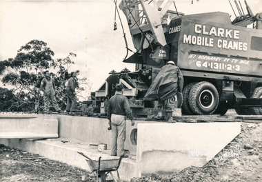
Photograph, Construction of Lower Plenty Bridge, Main Road, c.August 1966, 1966
Black and white photograph of construction of northern Lower Plenty Bridge 1969bridges, bridge construction, main road, lower plenty, plenty river, cranes -
 Orbost & District Historical Society
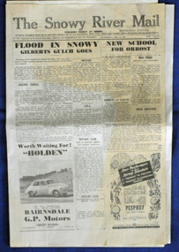
newspaper, 15.2.1950
The Snowy River Mail is a weekly newspaper published in Orbost in the Shire of East Gippsland, Victoria, Australia. Previously published as The Snowy River mail and Tambo and Croajingolong gazette from 1890 to 1911. The Gippsland Courier merged with the Snowy River Mail when proprietor Lachlan Ross moved to Orbost in 1910. In 1999 the paper was acquired by the Yeates family when the Hollins family retired from the newspapers business. The paper is still being produced by the fourth generation of the Yeates family as part of East Gippsland Newspapers. The flood in 1950 was a significant Orbost event. This newspaper is a contemporary record of a significant local events.A Snowy River Mail newspaper dated 15,.2.1950. It contains news articles and advertisements in black/white print. There is an artcle about the Orbost floods.newspaper snowy-river-mail flood-1950-orbost -
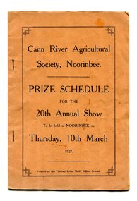 Orbost & District Historical Society
program, Snowy River Mail, 1927
Cann River is a town in the East Gippsland region of Victoria in Australia. The town is located on the Cann River at the junction of the Princess Highway and the Monaro Highway, in the Shire of East Gippsland. Before 1929 the original Cann River settlement was where Noorinbee now stands.Agricultural shows are an important part of cultural life in small country towns and these shows form an integral part of local history. This item reflects the significance of a volunteer group which no longer exists.A stapled paper program, orange with black print,"Cann River Agricultural Society, Noorinbee Prize Schedule for the 20th Annual Show to be held at Noorinbee on Thursday 10th March 1927" inside a rectangular black frame. -
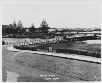 Port Fairy Historical Society Museum and Archives
Postcard, Moyne River Port Fairy
This bridge was built in 1902, replacing a previous structure that crossed the Moyne River from 1857 and linked Belfast with Belfast East, as the two areas of Port Fairy were then known. Prior to that, passage over the river was via a ford (an underwater stone track that allowed wagons to cross when the river was low) located just north of where the current car bridge stands. The present bridge survived the great flood of 1946, but has been the subject of innumerable patch-up jobs over its 114 years. In 2012, the bridge underwent a detailed structural assessment and was given the OK for the next eight to 10 years, notwithstanding the need for regular maintenance works. At the time, it was estimated a new bridge would cost between $2-3 million. It was extensively refurbished in 2016Sole means for traffic to cross to the east side of Port FairyBlack and white photographMoyne River Port Fairyriver, moyne, bridge, road -
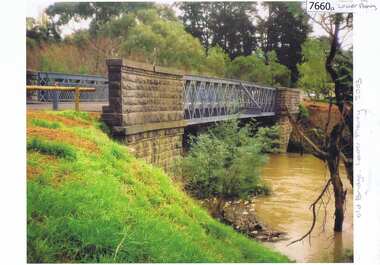
 Eltham District Historical Society Inc
Negative - Photograph, Old Lower Plenty Bridge, 18 April 1998
Plenty River reflections through the old iron Lower Plenty Bridge; Autumn Excursion to Lower Plenty area. The blocked-off iron bridge at Lower Plenty - now re-opened and used as a footway/bike path section joining the Yarra River path.Roll of 35mm colour negative film, 2 strips and associated colour printKodak Gold 200-6activities, lower plenty bridge, autumn excursion, eltham district historical society, lower plenty -
 Eltham District Historical Society Inc
Photograph, Construction of Lower Plenty Bridge, Main Road, c.August 1966, 1966
Black and white photograph of construction of new bridge, Main Road, Lower Plentybridge construction, main road, lower plenty, plenty river, bridges -
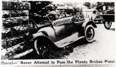 Eltham District Historical Society Inc
Photograph, Moral - "Never attempt to pass the Plenty Bridge Hotel"
Black and white photograph of a newspaper story about an accident at Lower Plenty Bridgelower plenty, bridge, main road, lower plenty bridge, transport, automobile, accident -
 Greensborough Historical Society
Photograph - Photograph (Copy), Anne Paul, Old bridge, Lower Plenty 2003, 2003_12
Two views of the old bridge over the Plenty River in Lower Plenty.2 colour photographs printed on paper, handwritten captionslower plenty, plenty river, floods, edward willis drive lower plenty -
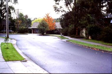 Greensborough Historical Society
Slide - Photograph, John Ramsdale, Lower Plenty houses: Slide 79, 1990s
Photograph shows a residential street in Lower Plenty - the Plenty River is behind.Part of the John Ramsdale collection of slides and audio visual material.Colour photograph scanned from slide.No caption. Printed maker's mark on slide "Kodak Kodachrome Slide"lower plenty, plenty river, residential development -
 Tatura Irrigation & Wartime Camps Museum
Photograph, Goulburn River, 1880
Taken by photographer for State Rivers and Water Supply CommissionMedium sized black and white photograph. Red gum and man on river bank in foreground - fast flowing river - opposite bank shown upper corner.victoria state rivers and water supply commission, goulburn river -
![View on the Upper Buckland River / [by] Nicholas Caire, circa 1876](/media/collectors/550653872162f11fb04854aa/items/57830fc0d0cdd1176c450fda/item-media/57831013d0cdd1176c454bda/item-fit-380x285.jpg) Kew Historical Society Inc
Kew Historical Society IncPhotograph, Anglo-Australasian Photographic Company, View on the Upper Buckland River, c. 1876
Nicholas Caire was born on Guernsey in the Channel Islands in 1837. He arrived in Adelaide with his parents in about 1860. In 1867, following photographic journeys in Gippsland, he opened a studio in Adelaide. From 1870 to 1876 he lived and worked in Talbot in Central Victoria. In 1876 he purchased T. F. Chuck's studios in the Royal Arcade Melbourne. In 1885, following the introduction of dry plate photography, he began a series of landscape series, which were commercially successful. As a photographer, he travelled extensively through Victoria, photographing places few of his contemporaries had previously seen. He died in 1918. Reference: Jack Cato, 'Caire, Nicholas John (1837–1918)', Australian Dictionary of Biography.An original, rare photograph from the series 'Views of Victoria: General Series' by the photographer, Nicholas Caire (1837-1918). The series of 60 photographs that comprise the series was issued c. 1876 and reinforced a neo-Romantic view of the Australian landscape to which a growing nationalist movement would respond. Nicholas Caire was active as a photographer in Australia from 1858 until his death in 1918. His vision of the Australian bush and pioneer life had a counterpart in the works of Henry Lawson and other nationalist poets, authors and painters.‘View on the upper Buckland River’ : Views of Victoria (General Series) No.46 : Albumen silver photograph | Photo on card with Title and Description on reverse | Mounted 24 x 30 cm; Photo 12 x 17 cm.On Reverse: ‘The Buckland River is situated near the western extremity of the Australian Alps, and forms one of the sources of the Ovens River. Its watercourse is very shallow, except in flood time. Our illustration is taken on the upper portion of the River, near Reeve’s dam.’nicholas caire (1837-1918), buckland river (vic), landscape photography - victoria -
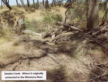 Stawell Historical Society Inc
Photograph, Swedes Creek where it originally connected to the Wimmera River 2017
Swedes Creek where it originally connected to the Wimmera River. 2017.Coloured photograph of a disturbed timber area.Swedes Creek - Where it originally connected to the Wimmera River.water -
 Greensborough Historical Society
Photograph - Photograph (Copy), Anne Paul, Water Watch under old bridge, Lower Plenty 1990s, 1990s
Two views of "Waterwatch" working around the bridge over the Plenty River in Lower Plenty.2 colour photographs printed on paper, handwritten captionslower plenty, plenty river, waterwatch -
 Wodonga & District Historical Society Inc
Album - Ringer's River by Des Martin - Plate 14 - O'Day visits the O'Hara's homestead
Daylight O'Day swims the river alone and, instead of going straight back to Gooloora, rides up-river a little to call at O'Hara's slab homestead where he is given a very warm welcome by young Erin O'Hara. Ellen Tenteye as Erin O'Hara.The album and images are significant because they document literature written by a prominent member of the Wodonga community. The presentation of this precis was supported by several significant district families and individuals.Ringer's River Album Coloured photo Plate 14des martin, many a mile, ringer's river, northeast victoria stories -
 Lakes Entrance Historical Society
Photograph - Mitchell River Bairnsdale Victoria, 1991 c
taken from across the river looking back towards picnic area on right, site of old swimming pool below Court House. Colour photograph of Mitchell River Bairnsdale Victoria. Also three colour photographs of Mitchell River at Bairnsdale taken autumn 1991 settlement, rivers, topography -
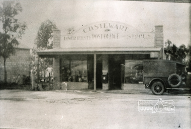 Eltham District Historical Society Inc
Photograph, Lower Plenty Post Office and store
Black and white photograph of early view of old Lower Plenty Post Office and storelower plenty, post office, shops, main road -
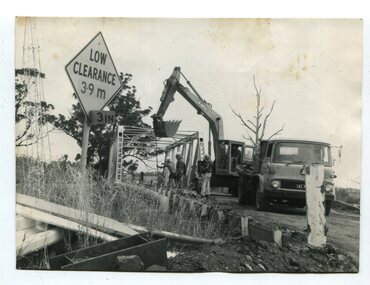 Orbost & District Historical Society
black and white photographs, 1976 - 1977
These photographs are of the demolition of the road bridge across the Snowy River at Orbost. This bridge over the Snowy River was opened on July 4 1922. It was constructed in 1922 alongside the previous suspension bridge. Its building was a combined effort of the Victorian Railways and the Country Roads Board at a cost of 35,000 pounds. It was replaced in 1976 by the present bridge after several major floods.This bridge was replaced in 1976 after several major floods. These photographs are pictorial records of its demolition.Four black / white photographs of the demolition of a road bridge across a river. In them can be seen trucks, excavators and workmen. In 3246.1 there is a triangular road sign - "LOW CLEARANCE 3.9m"bridge-demolition orbost-snwoy-river-bridge -
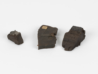 The Beechworth Burke Museum
Geological specimen - Coorongite
Coorongite is a dark, rubber-like, highly resilient structureless algal deposit. In the Coorong district of South Australia it occurs in moderate quantities associated with the coastal swamps and sand dunes which extend for a considerable distance east of the mouth of the Murray. This particular specimen was recovered from the south of the Coorong River, South Australia. A type of sediment rich in organic matter, Coorongite is the unlithified end-member of the sapropelic coal series. The members of the sapropelic coal series can be ranked in order as sapropel (the unlithified form), sapropelic-lignite, and sapropelic-coal (the lithified forms) based on increasing carbon content and decreasing volatile content. Sapropel (Coorongite) is an unlithified dark, pulpy, fine organic mud containing concentrations of algae and miospores that are more or less identifiable. Coorongite is typically found as an algae like substance, that can be found in irregular size pieces. Coorongite was believed to be dried up oil due to its rubber-like texture. The Coorongite is also soft to the point where it can be cut into with a knife or it can be broken and torn by hand. Otherwise known as 'Kurangk', the Coorong River is home to the Ngarrindjeri people, which acts as both a place for gathering food and a spiritual place. In 1852 the first sight of Coorongite was found along the Coorong River. The finders mistook the Coorongite for dried up oil, which lead to the belief that there were oil reserves under the Coorong River. Between the 1860s and the 1930s the Coorong River became a place where mining oil and Coorongite became precedent. Nowadays, the local council and the South Australian Government are working together with the Ngarrindjeri people to sustain and preserve the Coorong River and the culture that is with it. Soon after gold was discovered in 1851, Victoria’s Governor La Trobe wrote to the Colonial Office in London, urging ‘the propriety of selecting and appointing as Mineral Surveyor for this Colony a gentleman possessed of the requisite qualifications and acquaintance with geological science and phenomena’. Alfred Selwyn was appointed geological surveyor in Australia in 1852 which began the Geological Survey of Victoria. Selwyn went on to collect geological samples and catalogue thousands of specimens around Australia. In 1853-69 the Geological Survey issued under Selwyn's direction sixty-one geological maps and numerous reports; they were of such high standard that a writer in the Quarterly Journal of the Geological Society of London bracketed the survey with that of the United States of America as the best in the world. During his years spent in Australia, Selwyn collected numerous significant geological specimens, examples of which are held in collections such as the Burke Museum.Coorongite is considered to be a mineral with a unique texture, where it can be both hard and soft. Coorongite can also be considered to be a rare mineral, as it is only located along the Coorong River and due to the mining of it, has left very few sources. It was believed at one point that Coorongite could be used to replace oil. This specimen is part of a larger collection of geological and mineral specimens collected from around Australia (and some parts of the world) and donated to the Burke Museum between 1868-1880. A large percentage of these specimens were collected in Victoria as part of the Geological Survey of Victoria that begun in 1852 (in response to the Gold Rush) to study and map the geology of Victoria. Collecting geological specimens was an important part of mapping and understanding the scientific makeup of the earth. Many of these specimens were sent to research and collecting organisations across Australia, including the Burke Museum, to educate and encourage further study.Three solid varyingly hand-sized pieces of wooden appearing organic matter derived from the river in the Coorong District in South Australia. A rubber-like, highly resilient structureless algal deposit.Specimen 245 page 69 / in Descriptive Register / "Elcestic Bitumen, / Coorangite" South of / Coorung River, South Australia . / C. WIllman / 15/4/21burke museum, beechwoth, indigo shire, beechworth museum, geological, geological specimen, mineraology, coorong, coorong river, kurangk, ngarrindjeri, south australia, coorongite, coorongite specimen -
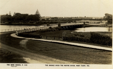 Port Fairy Historical Society Museum and Archives
Postcard, The Rose Series / The Rose Stereographs, The Bridge over Moyne River, Port Fairy Vic
Black and white Photograph of the Moyne river road bridge with the botanical gardens in the left background and some huts built possibly on Hughes AvenueThe Rose Series P.1123 copyright.- The Bridge over the Moyne River Port Fairy Vic.moyne bridge, hughes avenue, gipps street, river, dunes, botanical gardens -
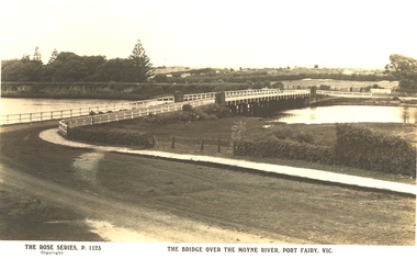 Port Fairy Historical Society Museum and Archives
Postcard, The Rose Series / The Rose Stereographs, The Bridge over Moyne River, Port Fairy Vic
Black and white Photograph of the bridge over the Moyne river with the Botanical Gardens on the left in the background and also some huts on Hughes Avenue in the backgroundThe Rose Series P. 1123 copyright- The Bridge over the Moyne River Port Fairy Vic.moyne bridge circa 1930, moyne river, bridge, river, botanical gardens -
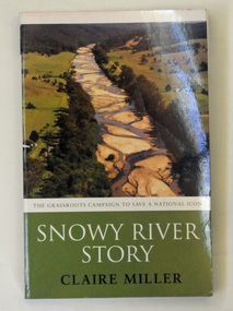 Orbost & District Historical Society
book, Snowy River Story, April 2005
This book recounts the story of the campaign by Dalgety and Orbost to restore water to the Snowy River. Claire Miller is a senior journalist for The Age newspaper with a special interest in the environment. She has covered this campaign since 1999.This book recounts the story of the campaign by Dalgety and Orbost to restore water to the Snowy River. It is significant to this collection as many of the current residents of Orbost were involved in the campaign.A 270pp paperback book titled Snowy River Story written by Claire Miller. On the front cover is a coloured photograph of the Snowy River at Bete Bolong. It documents the story of the campaign to save the Snowy River.snowy-river snowy-mountains-hydro-electric-scheme environmental -
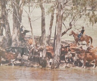 Wodonga & District Historical Society Inc
Album - Ringer's River by Des Martin - Plate 21 - Swimming cattle across to Victoria
But O'Day, the general, has chosen this particular time to ride up river and meet a mob of cattle that Charlie Clowes is bringing down for him from Camoola. In the first of many such successful operations the cattle are swum across to Victoria at the point where O'Day's run, Brightons, comes down to the river.The album and images are significant because they document literature written by a prominent member of the Wodonga community. The presentation of this precis was supported by several significant district families and individuals.Ringer's River Album Coloured photo Plate 21des martin, many a mile, ringer's river, northeast victoria stories -
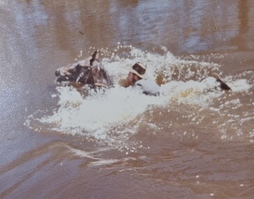 Wodonga & District Historical Society Inc
Album - Ringer's River by Des Martin - Plate 29 - Keiran drowns
A flash flood caused by the cloudburst upstream catches them all in the river and Keiran is drowned.The album and images are significant because they document literature written by a prominent member of the Wodonga community. The presentation of this precis was supported by several significant district families and individuals.Ringer's River Album Coloured photo Plate 29des martin, many a mile, ringer's river, northeast victoria stories