Showing 575 items
matching road construction building
-
 Surrey Hills Historical Society Collection
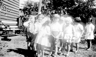
Photograph, Miss Win Jacobs Kindergarten at Wyclif Church Surrey Hills in 1940s
8 boys and girls playing with rope on the grass outside a timber building with an outdoor chair with wooden slats and wrought iron arms and legs. Mature trees are hanging over the fence in the background. A boy is wearing a cotton reel necklace. There is a toy truck on the left hand side of the photo.children, furniture, norfolk road, surrey hills, pre schools, ropes, cast iron work, outdoor furniture, construction materials, wyclif church congregation, jacobs, win (miss), yarnold, win (mrs), craft and craft equipment -
 Surrey Hills Historical Society Collection
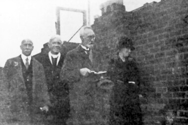
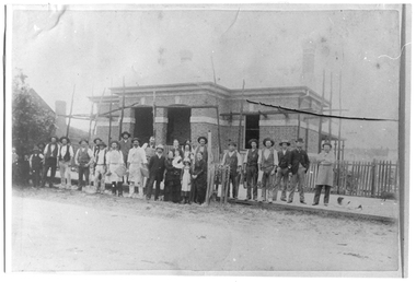
Photograph, Opening of Surrey Hills Presbyterian Church Sunday School in 1929
People are identified L to R: Mr P. Sinclair, Rev. J.K. Robertson, Mr Thomas Hogg, Miss SneddonBlack and white image with three men and one lady. One is a clergyman, another man is holding a trowel. They are standing outside a partly constructed building, with a window frame in the background.clergy, sunday schools, construction materials, clothing and dress, building structure and establishment, trowels, mr p sinclair, rev j k robertson, mr thomas hogg, miss - sneddon, churches, st stephens presbyterian church -
 Surrey Hills Historical Society Collection
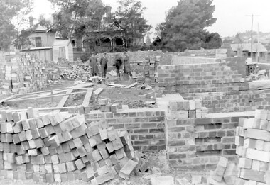
Photograph, Holy Trinity Church of England, Surrey Hills during construction, 1922, 1922
St George's Church of England, Mont Albert was built in 1886 and from 1904 until 1907 was known as Holy Trinity, Surrey Hills. As the population increased there was a need for a church in Surrey Hills. This brick church was consecrated in 1922 and replaced the earlier one built in 1907 on the adjacent site in Union Road. The house behind the church at 1 Montrose Street belonged to Mr W B Vine. There are 2 copies: the original donated print and an enlargement. The original is mounted on card with photo mounts along with 884, 885, 886 and 512. It measures 13 cm x 9 cm. Norman Carter took many photos of Surrey Hills and Mont Albert in the 1920s; many were associated with events and activities of the Church of England.Black and white photo of 3 men inspecting the construction site of the Holy Trinity Church of England in Union Road, Surrey Hills. The foundations are surrounded by piles of bricks. In the background is a small timber shed and beyond that a timber Edwardian home partly hidden by foliage.churches, holy trinity church, anglican church, building construction, montrose street, w b vine -
 Surrey Hills Historical Society Collection
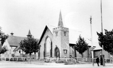
Photograph, Holy Trinity Church of England, Surrey Hills post 1926, After 1926
St George's Church of England, Mont Albert was built in 1886 and from 1904 until 1907 was known as Holy Trinity, Surrey Hills. As the population increased there was a need for a church in Surrey Hills. This brick church was consecrated in 1922 and replaced the earlier one built in 1907 on the adjacent site in Union Road. After construction of the brick church, the earlier one became a Sunday School. The copper spire was added in 1926, which dates this photo as post-1926. Norman Carter took many photos of Surrey Hills and Mont Albert in the 1920s; many were associated with events and activities of the Church of England.Black and white photo of the 'newly' constructed brick Holy Trinity Church in Union Road, Surrey Hills taken from near the south-west corner of Guildford Road. Further up the hill is the earlier church. Both buildings are bounded by a simple post and rail fence. Immature street trees are planted on both sides of Union Road.churches, holy trinity church, anglican church, sunday schools, norman carter -
 Surrey Hills Historical Society Collection
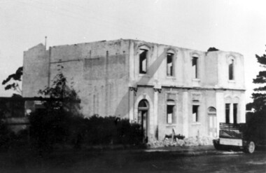
Photograph, Demolition of Tower House Day and Boarding School, Surrey Hills in 1932 (2), 20/08/1932
This building dated back to the 1880s and had previously operated as Delany's Hotel and then the Royal Hotel. It was built near the site of the original Delany's Hotel, built in 1856. The Royal Hotel closed in 1921 after the area voted to be a 'dry area'. Tower House Day and Boarding School operated from 1921 until 1932. Norman Carter took many photos of Surrey Hills and Mont Albert from the 1920s; many were associated with events and activities of the Church of England.Black and white photo of a partially demolished building. The roof is missing and there is a pile of rubble along the front wall. What remains indicates that it has been a large building in the Victorian style. There is a mixture of treatments to the surrounds of the windows. On the RHS part of a truck can be seen.Original: Top LH corner in blue biro "see matching photo"; top RH corner "498 / spare"; bottom LH corner in lead pencil "N Carter"; bottom RH corner in blue biro "20-8-32" - all Jocelyn Hall's handwriting.tower house day and boarding school, schools, education, royal hotel, hotels, construction and demolition, dry area, licensing polls, temperance movement, delany's hotel, norman carter -
 Surrey Hills Historical Society Collection
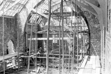
Photograph, Holy Trinity Church under construction: interior view, 1921, 1921
Norman Carter took many photos of Surrey Hills and Mont Albert from the 1920s; many were associated with events and activities of the Church of England.Black and white photo taken from the scaffolding inside Holy Trinity Anglican Church, Surrey Hills showing the brick skin of the building and the timber frame of the roof and floor.On back of original in pencil: "9th Oct 1921" and in a different hand in biro: "Holy Trinity Church / Surrey Hills / Progress of building / 9.10.1921"holy trinity, churches, anglican churches, construction and demolition, norman carter -
 Surrey Hills Historical Society Collection
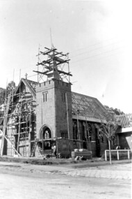
Photograph, Holy Trinity Church under construction: exterior view, 1921, 1921
Norman Carter took many photos of Surrey Hills and Mont Albert from the 1920s; many were associated with events and activities of the Church of England.Black and white photo taken from diagonally opposite Holy Trinity Anglican Church, Surrey Hills in Union Road, showing the brick skin of the building and the timber frame of the roof. There is scaffolding on the front face and around the spire.On back of original in pencil: "9th Oct 1921" and in a different hand in biro: "Holy Trinity Church / Surrey Hills / Progress of building / 9.10.1921"holy trinity, churches, anglican churches, construction and demolition, norman carter -
 Surrey Hills Historical Society Collection
Folder of information, Libby Cavenagh's 1990 building census of Wandsworth Road, Surrey Hills, 1990
Libby Cavenagh was Secretary of the Surrey Hills Historical Society. She completed this study as part of a Diploma of Local History she was undertaking at the University of New England. At the time she lived in Wandsworth Road.This is a unique analysis of the housing stock of a complete street at one point in time. Many of the houses have been altered since the study was completed and quite a number have been demolished.Blue folder of A4 size. This contains an analysis of each house in Wandsworth Road in 1990 with details regarding building style, approximate age, materials used, fence design, presence or absence of a garage or carport and some comment on the garden elements. For most entries there is a coloured photo taken from the street. For some there are photocopies of real estate advertisements. There are a number of appendices including s a map of the breakdown of styles and materials; date of construction and other information from the Camberwell Building registers 1890-1934; entries re owners from Sands & McDougall directories, 1897-1937; map from Land Titles Office showing sub-division information; land auction advertisements; information re W J Vine; list of builders; references.wandsworth road, libby cavenagh -
 Surrey Hills Historical Society Collection
Book, City of Whitehorse Heritage Review (as it relates to Surrey Hills), 1999
A street by street survey of each of the proposed precincts was undertaken. For each precinct, building fabric was defined in terms of intactness, scale, construction type, architect and predominant eras of construction.A street by street survey of each of the proposed precincts was undertaken. For each precinct, building fabric was defined in terms of intactness, scale, construction type, architect and predominant eras of construction.cultural property, protection of historic sites, heritage overlay precincts, heritage review, building citations -
 Vision Australia
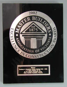
Plaque - Image, Master Builders Excellence in Construction Awards, 2002
In 2002, the Master Building Excellence in Construction Award (Excellence in Construction (Existing Building) 85M-110M) was presented to L.U. Simon Builders Pty Ltd for the National Information Centre, Vision Australia Foundation, Kooyong. This award hung in the main corridor of the building, opposite the middle doorway from the drop off area, from 2002 until the building's refurbishment in 2017.Black and silver coloured plastic plaquevision australia foundation, awards -
 Vision Australia
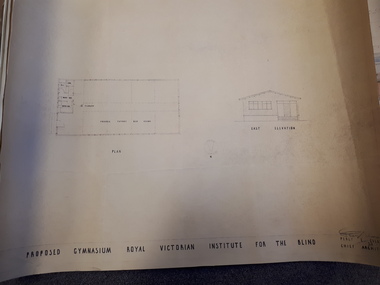
Plan - Image, Proposed Gymnasium Royal Victorian Institute for the Blind, 21 June 1950
In 1951 plans were made for the construction of a gymnasium to be situated in the grounds of St Kilda Road. These 4 plans specify the building construction notes, present front and east elevations, and show how part of the hall could be transformed into bedrooms in the future. There are 2 copies of each plan, consisting of identifical copies of the east elevation and different notes printed/handwritten on the front, side and top elevations. These were presented to the RVIB Board in Feburary 1951, according to the stamp on the back.2 architectural plans showing proposed gymnasium buildingPercy E Everett Chief Architectroyal victorian institute for the blind, plans -
 University of Melbourne, Burnley Campus Archives
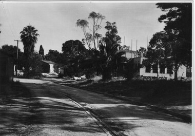
Photograph - Black and white print, Administration Building Under Construction, 1946-1947
Note by T.H. Kneen 20 February 1991, "View of new building under construction 1946/47. Building on left is Contractor's hut (Anderson of Ivanhoe) (Mr. Tom(?) Floyd foreman.) Road leads up to old point of entry to the gardens which enclosed the Pavilion, partially demolished at this stage."Black and white photograph. View of new building under constructiontom floyd, pavilion, anderson of ivanhoe, administration building, builder -
 Vision Australia
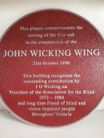
Plaque - Object, John Wicking Wing, 1996
Constructed in 1996, the new wing at Elanora Nursing Home was named after John Wicking, President of the Association for the Blind for over 10 years, and a strong supporter of the Association and it's work.1 round metal plate with raised inscriptionThis plaque commemorates the turning of the first sod in the construction of the John Wicking Wing, 21st October 1996. This building recognises the outstanding contribution by J O Wicking AM President of the Association for the Blind 1972-1984 and long time friend of blind and vision impaired people throughout Victoria.association for the blind, john wicking, elanora home (brighton), nameplates -
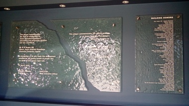 Vision Australia
Photograph (Item) - Image, Plaque to commemorate official openings at the and of Kooyong Centre in 2000 and 2001
The buildings at Kooyong have undergone various re-modelling and redesign over the years. These plaques commemorate the dual activities taking place at the Kooyong Centre, as it strove to adapt to the increasing need for technological support and the changes in information, day centre and supports needed by the blind and vision impaired community. These plaques were located in the corridor between reception and the day centre, but were dismantled during renovations in 2018.This plaque commemorates the start of construction of Vision Australia Foundation's information and technology facilities and was unveiled by Mr D R Argus AO, Patron Vision Australia Foundation, Chairman, Centenary Appeal in recognition of all who made this development possible for the lasting benefit of people who are blind or have severe sight loss. 27 March 2000, Malcolm Daubney, President. John Cook, Chief Executive Officer. This plaque commemorates the official opening of Vision Australia Foundation's Kooyong Centre by John Landy, AC, MBIE, Governor of Victoria, 11 October 2001. Building Donors: Don Argus, AO - Appeal Chairman, Shirley Admans, Amcor Limited, Aspect Consulting Pty Ltd, Atalina Nomines Pty Ltd, Robert Bosch (Aust) Pty Ltd, The William Buckland Foundation, Cadbury Schweppes Australia Ltd, Terry Cocks OAM, Coles Myer Ltd, Commonwealth Bank of Australia, Consolidated Paper Industries, John & Beverley Cook, The Craftsman Press Pty Ltd, Norma Crook, CSR Limited, Malcolm & Beverley Daubney, Don Draffin, Sir Andrew & Lady Fairley Foundation, Ford Motor Co. of Australia Ltd, Fortis Australia Ltd, Gandel Charitable Trust, Harold Gration, Dept of Health & Community Services, Peter Isaacson Publications Pty Ltd, Kayarem Pty Ltd, Kooyong Auxiliary, Kooyong Fair Committee, Lady Joan Law-Smith, Elaine Leahy, Eve & Lewis Lustig, Henry Malycon, Ann Miller, John Moule AM, Dame Elisabeth Murdoch, AC DBE, Sidney Myer Fund, National Australia Bank, Pacific Dunlop Ltd, Raleigh Paper Co Pty Ltd, Lady Catherine Ramsay, Rothschild Australia Ltd, Shell Australia Ltd, Slade & Partners, Springfield Auxiliary, Ian Roach AO, Rotary Club of Albert Park, Rotary Club of Hawthorn, The Top Opp Volunteers, Sir Donald & Lady Trescowthick Foundation Ltd, Graham Upton, John Wall OAM, John Wicking AM, Ian & Beverley Wilson, Woodside Petroleum Ltd.vision australia foundation, nameplates -
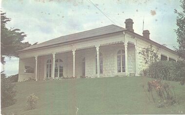 Port Fairy Historical Society Museum and Archives
Photograph
The construction of Seaview commenced in 1860, after David Talbot, purchased the land from James Atkinson,It had been suggested that it was intended to be double storied but there is no evidence of how that would have been accomplished. Following Talbot’s insolvency, Michael O’Reilly leased the house in 1862 until 1876 when he left for Melbourne.William Powling (Solicitor) acquired the house for Eight hundred and twenty three pounds in 1890 and lived there the rest of his life. His son Ernest Powling continued living there before selling it to Matthew Cathcart in 1917.Coloured photograph of White painted stone house with bay window to right and large verandahcottage, building, home, house, seaview -
 Falls Creek Historical Society
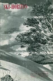
Journal - Ski-Horizon Vol. 2 No 10
Ski-Horizon is the official journal of the Federation of Victorian Ski Clubs which began publication in 1949. The were 26 original member clubs which included Albury Ski Club, Bogong Ski Club, Myrtleford Ski Club, Tallangatta and District Ski Club and Wangaratta Ski Club. Two pioneers of Falls Creek, Tom Mitchell, M.L.A., and Martin Romuld were Vice-Presidents of the Federation.This Journal is significant because it documents the early development of skiing in Victoria.The journal features stories and events chronicling developments in Victoria and internationally. Items related to the Falls Creek Area in this publication include:- Page 2: Albury Ski Club is set for a positive year. Present membership of the club is 130 and officials. recently elected are: -President, Mr. Fred Griffith; Vice-President and Booking Officer, Bob Howe; Secretary. Nell Newton; Asst. Sec., Angela Bowler; Treasurer. Sam Roxburgh; Social, Bruce Colquhoun: Trips, June Watson; Bus, Len Egan; Building. John Perger; Equipment, Peter Hadow. Page 3 Toni St. Elmo is planning the monster party the Bogong Ski Club will give at their Falls Creek Lodge on 4th August to the visiting N.Z. team. Page 8 - 9 Article - The Old Order Passes on the Bogong High Plains - an extensive response to the State Development Committee's Report "The Alpine Regions of Victoria; Skiing and Tourist Resorts" and suggestions for the construction of roads, ski tows and other facilities. A sketch map of Falls Creek Village is included.ski history victoria, federation of victorian ski clubs, development of falls creek -
 Falls Creek Historical Society
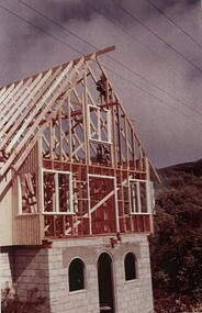
Photograph - Falls Creek Huette
The Falls Creek Huette was created as a result of the ideas, support and persistence of Charles Anton, Founder and First President of the Australian Alpine Club. It opened on the Queen’s Birthday weekend 1963, the same day as the Perisher Huette Work on prefabricating the walls commenced in Melbourne at the start of March 1963. Digging of the foundation trenches commenced on site on 19 March 1963. When the first snow fell on 20 March 1963 some of the construction was temporarily under snow. Fortunately, the site was not buried for long, although the deep mud that developed meant that every sheet of plaster along with all fittings and furniture had to be carried to the lodge from the main road. The first Falls Creek Huette had 14 beds in the bedrooms and an overflow area that could accommodate 6 more persons. It served the Australian Alpine Club until it was sold in 1971 and a much larger lodge was built on another site.These images are significant because they document the construction of an important building at Falls Creek, VictoriaImages from display at Falls Creek Museumfalls creek huette, falls creek lodges, charles anton, australian alpine club -
 Melton City Libraries
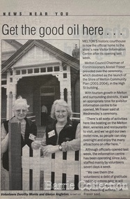
Newspaper, Get the good oil here…, 2001
"A court was established in Melton by 1864, when the first recorded case was heard before Mr BA Porter JP, with Mr A Carroll as the Clerk of Courts. John James was convicted of being drunk, for which he was fined five shillings or 24 hours imprisonment. The court was held in the ‘long room’ of the old Melton Hotel, before moving to rented accommodation at the Raglan Hotel, and finally to the Roads Board office. Tenders for construction of the present building were called for by the Public Works Department on 13th February 1892. The architect Samuel Edward Brindley was born in Birmingham, England, in 1842. He was articled to the local architect, J.R. Botham, FRIBA, before emigrating to Victoria where he was employed as an architect in the Education Department from 18 August 1873. With the amalgamation of the architectural branch of the Education Department with the Public Works Department in 1884, Bindley was placed in charge of Victorian government building design for the North-Western District. In 1975, the Melton and District Historical Society became concerned at hearsay that the court house was to be demolished to make way for carparking space. Melton had been declared a ‘satellite city’ and was developing rapidly. A new shopping centre had recently been built at a setback of 60 feet (c.18 metre) from 323-329 High Street, and the court house, together with the adjacent weatherboard police station, had been left standing alone. A new police station was planned, and the weatherboard police station was subsequently demolished. In its nomination of the building for National Trust classification the Society argued that the Court House was ‘the best of two early buildings left in the main street’ (the other being a bluestone hotel) and that its loss would be ‘tragic’. However the nomination was unsuccessful, the National Trust at the time judging that it was of no particular ‘distinction’ or ‘antiquity’. The building continued to be used as a court house at least until 1991 when the Department of Housing and Construction (formerly the PWD) conducted a heritage study of court houses. By this time Federation-era architecture had achieved acceptance within the heritage movement. The building was recognised as being ‘the only surviving example in brick of the Federation Queen Anne style which was used for court houses only twice.’ Twenty years later when it was proposed to modify the eastern façade of the building to accommodate a café, the M&DHS was again concerned. This time the National Trust objected that the proposed extension would be an over-development of the site, and questioned the changes to the interior court room furnishings and fittings. The site never appears to have been nominated to the Victorian Heritage Register. It has since been converted into the Shire of Melton Tourist Information Centre". Opening of the Visitor Centre in Meltoncouncil, local architecture -
 Kilmore Historical Society
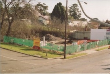
Photograph, Mobil Garage, 2006
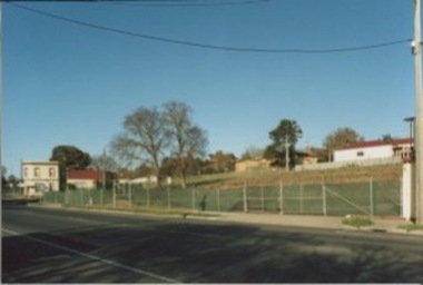
Previously Mobil Garage owned by Danny and Pat D'Elia until 2001. Then demolished in 2006.15cm x 10cm colour photograph of the corner of Lancefield Road and Sydney Street. Printed on matte photographic paper (Kodak brand) Recent demolished building with rubble piled up and green security fencing around the perimeter of the property. Sign for the Willowmavin Estate is visible advertising land sales. Multiple photographs with multiple views available.Printed on back: Development information: Premier service station, construction sites -
 Kilmore Historical Society
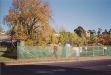
Photograph, Mobil Garage, 04/06/2007
Previously Mobil Garage owned by Danny and Pat D'Elia until 2001. Then demolished in 2006.15cm x 10cm colour photograph of the property on the corner of Lancefield Road and Sydney Street. Sydney Street view. Printed on glossy photographic paper (Konica brand) Recent demolished building with rubble piled up and green security fencing around the perimeter of the property. Multiple photographs with multiple views available.Printed on the back: Development information: Simon Yu Pharmacy s029 service stations, construction sites -
 Kilmore Historical Society
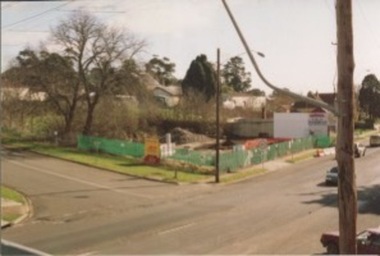
Photograph, Mobil Garage, 2007
Previously Mobil Garage owned by Danny and Pat D'Elia until 2001. Then demolished in 2006.15cm x 10cm colour photograph of the corner of Lancefield Road and Sydney Street. Printed on matte photographic paper (Kodak brand) Recent demolished building with rubble piled up and green security fencing around the perimeter of the property. Sign for the Willowmavin Estate is visible advertising land sales. Multiple photographs with multiple views available.Printed on the back: Development information: PREMIER service stations, construction sites -
 Kilmore Historical Society
Photograph, Mobil Garage, 2007
Previously Mobil Garage owned by Danny and Pat D'Elia until 2001. Then demolished in 2006.15cm x 10cm colour photograph of the corner of Lancefield Road and Sydney Street. Printed on matte photographic paper (Kodak brand) Recent demolished building with rubble piled up and green security fencing around the perimeter of the property. Visible in the background is 1 Powlett Street.Printed on the back: Development information: PREMIER service station, construction sites -
 Kilmore Historical Society
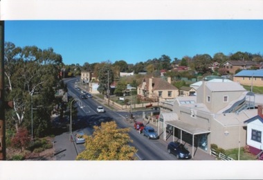
Photograph, Sydney Street 180 South, 05/2015
30cm x 20cm colour photograph from the top of the Old Town Hall looking south. You can spot the Hey Dey Arcade and Bramford Funerals. Many cars on the road and two people crossing the road.Written on the back: May 2015 From the top of Old Town Hall Looking South Photo Simon Marshall Photo by Simon Marshal Construction + Building Design -
 Melton City Libraries
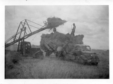
Photograph, Harvesting, 1950
1950 decade HAY FORK - A local invention. Bill and Arthur Gillespie and Bon Barrie In the early 1950’s Bill Gillespie of Bulmans Lane had been experimenting in developing a machine to improve the collection of hay sheaves at harvesting and stack building time. The ripened crop was cut by a reaper and binder which bundled the storks into sheaves tied with binder twine. The reaper and binder was towed by a tractor by the mid 1940s previously teams of draught horses were used to pull the reaper and binder. A photograph taken at the Barrie farm shows three binders the first being towed with a tractor and the others with horse teams. Two workmen were needed to operate the binder when cutting a crop. The sheaves collected on the binder and released onto the ground and were scattered across the paddocks. Using a conventional two pronged pitch fork the harvest hands collected the sheaves and placed each one cut edge on the ground in an upright position and layered with about 15 sheaves into an apex shape to form was is known as a stook. The shape of the stook allowed for drying and draining of water if rain had occurred. Prior to the invention of the mechanical hayfork this was a laborious task requiring each sheaf to be pitched onto a tray truck and moved to the location of the haystack. The mechanised HAYFORK was operated by one person on tractor greatly reducing the need for gangs of labourers. At harvest time farmers had relied on itinerant teams of workers descending on the district looking for work. The three Barrie brothers on their adjoining farms combined forces to cut their crop at its optimum time while the weather was in their favour. Up to many 20 workers at times formed a team in earlier times. Agricultural university students were also keen to gain practical experience in the field. Each of the brothers had a particular skill, and Tom Barrie was the expert on stack building. The district haystacks had a distinctive shape and could be recognised by their builder. Bill Gillespie’s first operational HAY FORK consisted of a large 13 pronged fork situated forward of the truck cabin. It was attached with iron girders and mounted on the rear of the cabin to the tray of his British Bedford truck. It was constructed in metal and iron and welded in the farmers work sheds. The mechanism was raised and lowered by the driver scooping along the ground to pick up a complete stook to raise high enough to deposit all the sheaves in one stook onto the stack or truck tray. The fork section was released by a rope and operated by the driver in the cabin. This model was trialled on the Barrie farm at Ferris Lane. It proved to be very successful and the Barrie/ Gillespie brothers went on to develop a HAYFORK which attached to a tractor and was operated with a series of levers and was raised and lowered hydraulically. It was detached from the tractor when stacking was completed. In its early days farmers travelling along the Western Highway called at the Barrie farm at Ferris Lane to inspect its construction and operation of the invention. It became a widely adopted by farmers throughout the State. It was being used on Wattie Palmer’s farm on Bridge Road Melton South in 1997. Farming in Melton, hay growing and stack building. agriculture, local identities -
 Melton City Libraries
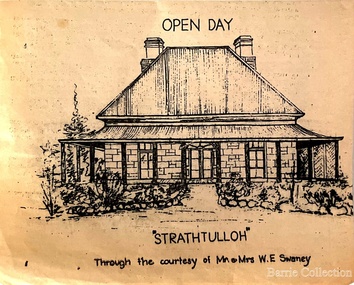
Drawing, Open Day at Strathtulloh, Unknown
"Strathtulloh, 1402-1600 Greigs Road, Melton South, is significant as an early property in Victoria, retaining different eras of pioneering dwellings, ranging from a ruin to a fine Colonial style homestead. The property has close historical association with the early settlement of the Melton district, and was owned by the Henty family in the 1840s. The Strathtulloh property was alienated by the Crown in 1840 to Charles James Garrard, who sold it in 1848 to Charles and Stephen Henty, whose sister Jane and her husband Samuel Bryan lived there in the late 1840s. In 1853 the property then passed to William Tulloh, after whom the homestead was named. A primitive bluestone ruin of near the Toolern Creek, built of vesicular bluestone and mud mortar, is of unknown origin. It has commonly been assumed to pre-date 1840, and to have belonged to the original holder of the Exford lease, Dr Watton or Port Phillip Association member Dr Cotterill. This is unlikely, as the 1841 census records Dr Watton, and everyone else in the district, as living in a ‘wood’ dwelling. It may instead have been the residence of Garrard, and the Bryans, in the 1840s and an early map names a site near here as ‘Bryan’s outstation’. It is assumed that the two-level stone building that became the kitchen is the earliest intact building on the site, and was the first homestead; it is likely to date to the 1840s or 1850s. The main homestead is a substantial villa constructed of random coursed bluestone, with a verandah facing three sides, attic bedrooms with dormer windows, a fan light over the front door, a hipped roof originally clad in slate, and a large cellar. Although demonstrating characteristics of pioneering construction, such as unworked log beams, pit sawn beams, hand-sawn lintels and colonial door locks, documentary evidence shows that it was built c.1869. The homestead has now been structurally repaired and decoratively restored; a sympathetic new semi-detached rear extension was added in the early years of the 21st century. The former kitchen building has also undergone minor repairs and alterations". Strathtulloh Homestead at 1402-1600 Greigs Road, Melton Southlocal architecture -
Canterbury History Group
Photograph - Building Bradshaws Maling Service Station, 1969
Black and white photograph of construction work on Bradshaws Maling Service Station, from the west looking east, 1969canterbury, maling road, d.h.bradshaw auto service pty ltd, petrol stations, canterbury railway station, theatre place, shops -
 Tarnagulla History Archive
Photograph, Tarnagulla Post Office during construction, c.1885-1886
Murray Comrie Collection. Murray Comrie's information about Tarnagulla Post Offices to be added. This photograph is a fair copy created from an older original.Monochrome photograph of numerous people standing outside the then new Tarnagulla Post Office, during its construction.Handwritten: 'Post Office during building - 1886 opened'.tarnagulla, post office, construction, businesses, commercial road -
 Tarnagulla History Archive
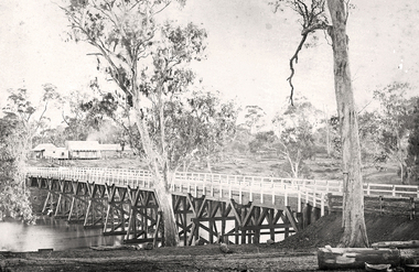
Photograph of the newly completed bridge at Newbridge, Victoria, c.1894, The newly completed bridge at Newbridge, Victoria, c.1894, 1894
... river infrastructure construction roads businesses buildings ...Murray Comrie Collection. This photograph is a well-preserved original. Monochrome photograph depicting the newly completed wooden bridge at Newbridge, Victoria. Position of photographer is on the east bank of the Loddon, looking west toward the present day Newbridge Pub.newbridge, bridge, loddon river, infrastructure, construction, roads, businesses, buildings -
 Harcourt Valley Heritage & Tourist Centre
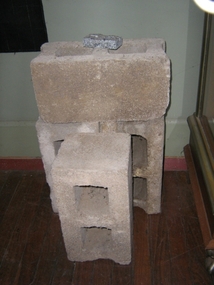
concrete blocks, 1914
Charles Seelenmeyer conducted Concrete Utilities Limited (Harcourt Cement Pipe Factory). Operated in Harcourt circa 1914 to 1930 in premises situated opposite the ANA Hall on what is now the road reserve. Principal raw material was sand from the adjacent waterway ( Barkers Creek.) Principal output was concrete drainage tiles for use in district orchards but concrete blocks were also produced for construction of homes and commercial buildings. At a time of rapid expansion of the orchards this industry provided a vital piece of orchard infrastructure, mostly buried and not now visible but nevertheless a very important feature of the valley’s horticultural industry.. Homes built with these concrete blocks are a distinct part of Harcourt’s housing stock. Harcourt Cement Pipe Co was an example of local initiative to solve a local problem using local materials. A collection of 4 concrete building blocks -
 Wodonga & District Historical Society Inc
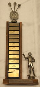
Award - Trophy - Terminus Hotel Wodonga Dart Club, 1985 - 1992
The Terminus Hotel was one of the earliest hotels in Wodonga, with clear links to the establishment of the railway line. It was an important business and meeting place from the original construction in 1873 until 1st June 1998 the Terminus Hotel when it was destroyed by fire. It provided a popular venue for social activities, including competitive darts, both through its own competition and as part of the Albury-Wodonga District Darts Association. The remains of the building were demolished in 1999. This is perpetual trophy for the Terminus Dart club based at the Terminus Hotel in Wodonga. This trophy recognises the winners of the Singles Championship from 1985 to 1992. Engravings on the front of the trophy indicate that the competition was held twice a year for most of the years recorded here.The Terminus Hotel was an important meeting place in Wodonga for more than 100 years. This item is representative of one of the social and sporting activities it provided for members of the local community.A perpetual trophy for the Terminus Dart club based at the Terminus Hotel in Wodonga. This trophy recognises the winners of the Singles Championship from 1985 to 1992. Down the front of the trophy, each name on a separate metal rectangle: 1985: A. Fleming 1985: K.Cook 1986: W. Larsen 1986: J. DeKruif 1987: L. Stokes 1987: J. DeKruiff 1988: J. DeKruiff 1989: C. Shaw 1989: H. Curphy 1991: J. DeKruiff 1992: J. DeKruiff 1992: J. DeKruifterminus hotel wodonga, terminus hotel darts, sport and recreation wodonga, albury-wodonga district darts association