Showing 1160 items
matching yarra river -- melbourne
-
 Eltham District Historical Society Inc
Photograph, Henley Flats - Yarra River
... melbourne henley flats yarra river Henley Flats - Yarra River Black ...Black and white photographHenley Flats - Yarra River henley flats, yarra river -
 Eltham District Historical Society Inc
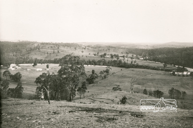
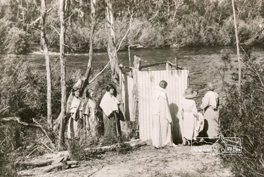
Photograph, Bend of Islands, c.1926
Bend of Islands is named after a group of small islands at a bend of the Yarra River near Watsons Creek. It is located near the town of Kangaroo Ground. The locationn was a long time favourite spot for locals and visitors to fish and swim in the river. This is one of a series of four photographs that depict a mainly young group of people recreating in the area, particularly enjoying horse riding. Possibly weekend campers. Photos taken about 1926-1928. In 1938 "The Argus" advertised weekend cabins at the Bend of Islands estate 5-are Yarra Yarra frontage in the Christmas Hills Gorge ideal for weekend cabins. "Bathing, fishing, canoeing, shooting may be enjoyed in ideal surroundings". This photo seems to be depicitng women waiting to use the shower near the river, or are they going swimming?Black and white photograph (reproduction)Bend of Islands, c.1926 bend of islands, camping, shower block, yarra river, swimming -
 Eltham District Historical Society Inc
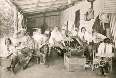
Photograph, Bend of Islands, c.1926
Bend of Islands is named after a group of small islands at a bend of the Yarra River near Watsons Creek. It is located near the town of Kangaroo Ground. The locationn was a long time favourite spot for locals and visitors to fish and swim in the river. This is one of a series of four photographs that depict a mainly young group of people recreating in the area, particularly enjoying horse riding. Possibly weekend campers. Photos taken about 1926-1928. In 1938 "The Argus" advertised weekend cabins at the Bend of Islands estate 5-are Yarra Yarra frontage in the Christmas Hills Gorge ideal for weekend cabins. "Bathing, fishing, canoeing, shooting may be enjoyed in ideal surroundings". Was this a church group? This photo depicts individuals "resting" on a verandah undertaking various solo activities including listening to their gramophone.Black and white photograph (reproduction)Bend of Islands, c.1926 bend of islands, camping, recreation, gramophone, group, campers -
 Eltham District Historical Society Inc
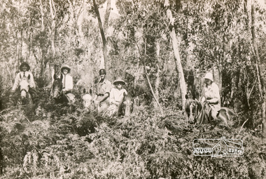
Photograph, Bend of Islands, c.1928
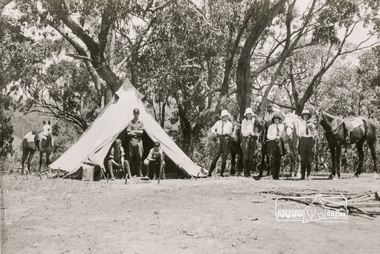
Bend of Islands is named after a group of small islands at a bend of the Yarra River near Watsons Creek. It is located near the town of Kangaroo Ground. The locationn was a long time favourite spot for locals and visitors to fish and swim in the river. This is one of a series of four photographs that depict a mainly young group of people recreating in the area, particularly enjoying horse riding. Possibly weekend campers. Photos taken about 1926-1928. In 1938 "The Argus" advertised weekend cabins at the Bend of Islands estate 5-are Yarra Yarra frontage in the Christmas Hills Gorge ideal for weekend cabins. "Bathing, fishing, canoeing, shooting may be enjoyed in ideal surroundings". Black and white photograph (reproduction)Bend of Islands, c.1928 bend of islands, horse riding, camping, tent -
 Eltham District Historical Society Inc
Photograph, Bend of Islands
Bend of Islands is named after a group of small islands at a bend of the Yarra River near Watsons Creek. It is located near the town of Kangaroo Ground. The locationn was a long time favourite spot for locals and visitors to fish and swim in the river. This is one of a series of four photographs that depict a mainly young group of people recreating in the area, particularly enjoying horse riding. Possibly weekend campers. Photos taken about 1926-1928. In 1938 "The Argus" advertised weekend cabins at the Bend of Islands estate 5-are Yarra Yarra frontage in the Christmas Hills Gorge ideal for weekend cabins. "Bathing, fishing, canoeing, shooting may be enjoyed in ideal surroundings". Black and white photograph (reproduction)Bend of Islands bend of islands, camping, tent, horse riding -
 Eltham District Historical Society Inc
Photograph, Heidelberg - River Yarra in flood at Heidelberg, 1934
Black and white photographCopied by Hugh Fisher, Photographer, 6 York Street Eltham A1679Bfloods, heidelberg, other areas, shire of eltham pioneers photograph collection, yarra river -
 Eltham District Historical Society Inc
Photograph, 1934 Floods at Eltham
Published in the Diamond Creek Basin Study, 1980 and identified at Diamond Creek, locality not identified, 1934. The location is actually looking south across the Diamond Creek towards Falkiner Street, beside the Main Road bridge at Eltham South from what is now part of Wingrove Park opposite Antoinette Boulevard. The bridge railing is just visible to the left of image. The large leaning Manna Gum beside the bridge still stands in 2021 alongside the Diamond Creek trail. In 1934 extensive flooding of the Yarra River and Diamond Creek set new records for flood plain level (Eltham Chronology, EDHS)Black and white photographCopied by Hugh Fisher, Photographer, 6 York Street Eltham A1678B Floods- Eltham - 1934floods, yarra river, eltham, flooding, diamond creek, flood -
 Eltham District Historical Society Inc
Photograph, Tom Prior, River Yarra
Situated near Sweeney's Lane, the house in the picture was owned by the man who was Commissioner that looked after the Aboriginees - Ivy Reynolds. Labelled by Ivy Reynolds' mother who had a good sense of humour.The Reynolds family were early settlers in Research. The Reynolds/ Prior collection of photographs were taken by Tom Prior, the maternal uncle of Ivy Reynolds, around 1900 and the 60 photos in the album give a fine overview of many of the landmarks of Research and Eltham over 100 years ago. lvy lived in the family home for many years at 106 Thompson Cres Research. Ivy's father, Ernst Richard Reynolds and grandfather, Richard Reynolds, lived at the same address. Ivy's father Richard worked for Mr. Trail on his property in Research. Reynolds Road is named after the family. Mr Tom Prior (wife Eva) worked at the Melbourne zoo. He was very innovative and made his own camera, using the black cloth hood to exclude the light. The photographs are a reminder of the rural nature of Research and Eltham and its rich heritage. Black and white photograph mounted in an album, the Reynolds/Prior Photograph Collection, this being one of 53 reproduced black and white images of early Eltham.The Reynolds/Prior Photograph Collection, Presented to the Eltham District Historical Society, 14 June 2006 by Ross McDonald. A second copy was also presented to the Andrew Ross Museum, Kangaroo Groundreynolds prior collection, eltham, yarra river, sweeneys lane -
 Eltham District Historical Society Inc
Photograph, Liz Pidgeon, View from Candlebark Park across the Yarra to the confluence of the Diamond Creek and Yarra River at Lennister Farm, 16 July 2017, 16 July 2017
... melbourne eltham candlebark park yarra river diamond creek lennister ...Born Digitaleltham, candlebark park, yarra river, diamond creek, lennister farm -
 Eltham District Historical Society Inc
Book, Koorie Heritage Trust, Koorie, 1991c
... melbourne Oldest culture - Yarra River and Port Phillip - Religion ...Oldest culture - Yarra River and Port Phillip - Religion - Serpents - Fire - In 1830 - First contacts - Massacre map - Survival - Identity - Resistance and rights (Pastor Sir Douglas Nicholls) - Land rights - From hand-out to hand-back - Aborigines in war - Sportspeople - Cultural heritage.Paperback; 57, [3] pages : illustrations, maps, ports ; 30 cm.ISBN 0724198105aborigines, social customs, koorie, victoria -
 Eltham District Historical Society Inc
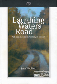
Book, Shire of Nillumbik, Laughing Waters Road: art, landscape & memory by Jane Woollard, 2016
"Laughing Waters has been a source of inspiration for many artists and designers, and was a natural extension of the dynamic art and lifestyle movement that began in the 1930s at Montsalvat. It was also an important site in the development of the Melbourne art scene in the 1960s and '70s, especially the earth building movement known as the Eltham Style. Since 2001 more than eighty artists have been in residence at Laughing Waters in Birrarung House and Riverbend. Their experiences and art making are woven together with Wurundjeri, European and family histories to create an evocative account of a special place in a bushy outer suburb of Melbourne." -- back cover. Eltham District Historical Society is acknowledged in the Acknowledgments section of this book.264 pages : illustrations, maps, portraits ISBN 9780994486707laughing waters, eltham, yarra river, artists, killeavey, mud bricks -
 Eltham District Historical Society Inc
Book, Doncaster Templestowe Historical Society, Templestowe: A Short History by Irvine Green, 1982
Templestowe is a suburb in the City of Manningham on the border of the Yarra River across from which is Eltham, in the Shire of Nillumbik24 p. : ill., 3 maps ISBN 0950092037templestowe -
 Eltham District Historical Society Inc
Book, Raymond Henderson, From Jolimont to Yering and along our Yarra valleys with Neuchatel's bachelor vignerons / Raymond Henderson, 2006c
... melbourne yarra river valley wine making vineyards ISBN 0958135851 ...Hardback with dust jacket; 426 p. : ill. (some col.), geneal. tables, maps, ports. ; 31 cm.ISBN 0958135851yarra river valley, wine making, vineyards -
 Eltham District Historical Society Inc
Book, North Warrandyte Landcare Group, Osborne Peninsula prepared by North Warrandyte (Osborne Peninsula) Landcare Group Inc, 2009
History of North Warrandyte Osborne Peninsula39 p. : ill., map ; 20 x 27 cm.[pasted inside front cover is a typed letter promoting the book addressed to "Dear Resident", dated 2nd August 2009] north warrandyte history, yarra river, osborne peninsula warrandyte -
 Eltham District Historical Society Inc
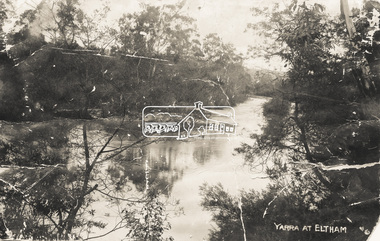
Photograph - Photo postcard, J.H. Clark, Yarra at Eltham, c.1910
This card depicts the Yarra River at Eltham circa 1910. It was addressed to "Mr J. L. Brown, "Elthamville", Tinning Street, Brunswick" most probably from an extended family member. From the same collection as accession no 00779, (Pond near Eltham Park) and no. 00780 (Eltham, J.H. Clark Photo - dated 20 May 1911). Sending postcards to family and friends including short messages was a common form of communication in the early 20th century. Photographer: J.H. Clark John Henry Clark was the youngest of three boys born to William Henry Clark (1823-1877) and Maria White (1843-1914). He and his brothers, William Charles Clark (1872-1945), Clement Kent Clark (1874-1912) operated a photography business (Clark Bros.) from 25 Thomas Street, Windsor near Prahran during the period c.1894 to 1914. Following death of Clement in September 1912 and their mother in 1914, the Clark Bros business appears to have dissolved, the premises demolished, and a new house was under construction in 1915. John set up business independently in 1914 operating out of 29 Moor Street, Fitzroy where he is registered in the 1914 and 1915 Electoral Rolls. By 1916 John had relocated to Eltham where he continued his practice as a photographer and took many of the early images around the district of Little Eltham. Around 1930 John changed professions and opened a small cobbler's shop in 1931 near the pond opposite Dalton Street adjacent to the Jarrold family cottage. He never married and continued his profession as a bootmaker from this little shop, maintaining a close relationship with Mrs Jarrold for the rest of their lives. His bootmaker shop remains today beside the Whitecloud cottage and is one of only three remaining shops in the area from the early 20th century. There are a couple of images of Eltham taken by Clark Bros. in the Eltham District Historical Society collection, one such example being Hunniford’s Post Office with Miss Anne Hunniford out front (EDHS_00140 - marked on the back of the print, Clark Bros., 25 Thomas St. Windsor), which would date this image between c.1894 and 1914. Other early images of Eltham taken by John Henry Clark are marked on the face “J. H. Clark Photo” and it is assumed these are dated between 1914 and 1930. It is noted that the Grant of Probate for John H Clark of Eltham South dated 5 April !957 (513/387) records his occupation as "X Photographer".Sending postcards to family and friends including short messages was a common form of communication in the early 20th century.Postcard in very poor condition which has been removed from an album. Glue residue and album page adhering preventing information being readFront: Yarra at Elthameltham, yarra river, brown family, j.h. clark photo -
 Eltham District Historical Society Inc
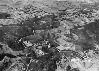
Photograph, Aerial view of Yarra River near Kangaroo Ground - Bend of Islands area
Sepia aerial view of Yarra river at Bend of Islands; Henley Road on left in foregroundbend of isles, kangaroo ground, yarra river, henley road -
 Eltham District Historical Society Inc
Photograph, Russell Yeoman, Warrandyte Bridge, c.1970, 1970c
... melbourne warrandyte yarra river bridges Black and white photograph ...Black and white photograph of Warrandyte Bridge over Yarra River c.1970warrandyte, yarra river, bridges -
 Eltham District Historical Society Inc
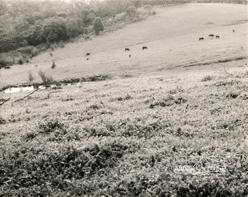
Photograph, George W. Bell, River Flats, Sweeneys Lane, 1960s
... melbourne sweeneys lane yarra river eltham farming george w bell ...Black and white photograph Yarra River Flats, Sweeneys Lane, Eltham c.1960ssweeneys lane, yarra river, eltham, farming, george w bell collection -
 Eltham District Historical Society Inc
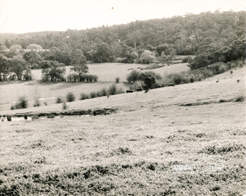
Photograph, George W. Bell, River Flats, Sweeneys Lane, 1960s
... melbourne sweeneys lane yarra river eltham farming george w bell ...Black and white photograph of Yarra River Flats, Sweeneys Lane, Eltham c.1960s.sweeneys lane, yarra river, eltham, farming, george w bell collection -
 Eltham District Historical Society Inc
Photograph, Sweeneys Lane looking southwest, Dec 1984, 198412
... melbourne sweeneys lane yarra river eltham thomas sweeney culla hill ...Two colour photographs of view south across Sweeneys flats and Yarra River, Sweeneys Lane, Elthamsweeneys lane, yarra river, eltham, thomas sweeney, culla hill -
 Eltham District Historical Society Inc
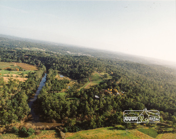
Photograph, Yarra River, Sweeneys flats, 1994c
... melbourne sweeneys lane yarra river culla hill thomas sweeney aerial ...Colour photogrpah of oblique aerial view looking east over Yarra River and Sweeneys flats c.1994sweeneys lane, yarra river, culla hill, thomas sweeney, aerial photographs -
 Eltham District Historical Society Inc
Book, Mick Woiwod, Another view of Kangaroo Ground : its land & its people / Mick Woiwod, 2009
Paperback; 54 p. : ill. (some col.), maps, port ; 30 cm.Inscribed and signed by Author wurundjeri, social customs, place names, yarra river, environment, kangaroo ground, culture, aborigines -
 Eltham District Historical Society Inc
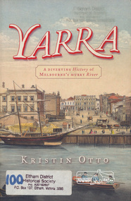
Book, Kristin Otto, Yarra : a diverting history of Melbourne's murky river / Kristin Otto, 2005
"It was John Wedge, Batman's private surveyor, who named the Yarra Yarra. In September 1835 he was at the Turning Basin with some Kulin and heard them identify the river as it came over the Falls as, he wrote, 'Yarrow Yarrow'. It was only some months later that Wedge discovered they had been referring to the pattern and movement of water over the Falls, not the river itself. And ever since, it has been the Yarra's fate to be misunderstood: maligned for its muddiness, ill-used as sewer and tip; scooped, sculpted, straightened and stressed, 'cleaned up' to the detriment of its natural inhabitants; built-over, under and beside; worked mercilessly and then bridged almost to maritime extinction. In Kristin Otto's superbly entertaining new history, the whole sorry tale is laid bare. From the creation stories of Kulin owners and geologist blow-ins (and Robert Hoddle's bad-tempered expedition to the headwaters) to the twenty-first-century waterside building boom, Otto traces the course of Melbourne's murky river. Erudite, affectionate and witty, with more meanders and diversions than the river itself, Yarra is both a fascinating read and a fitting tribute to the 'noble stream'." -- Publisher's website.Paperback; [viii], 245 p. : illus., maps ; 24 cm.ISBN 1920885781yarra river -
 Eltham District Historical Society Inc
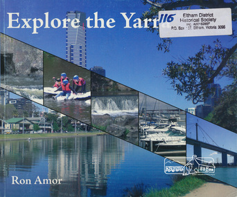
Book, Ron Amor, Explore the Yarra / Ron Amor, 2009
... melbourne yarra river yarra river valley ISBN 9780980308525 ...Paperback; 101 p. : ill. ; 21 x 25 cm.ISBN 9780980308525yarra river, yarra river valley -
 Eltham District Historical Society Inc
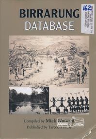
Book, Tarcoola Press, Birrarung Database compiled by Mick Woiwod, 2012
Sister publication to "Coranderrk database". This is a compilation of Mick Woiwod's research material, gathered over many years with information on the history of the Wurundjeri people of the Yarra Valley, from the time of first European contact. The publication runs in excess of 140,000 words. Its prime focus is the Yarra River as it has been understood by its Wurundjeri people. Includes a compilation of those difficult to locate "brief snatches of the action" collated under headings with in each instance, the provenance as to source and / or author included. Themes include: agriculture, law, ceremony, language, reconciliation, retribution, lifestyle, art & craft, climate, personalities, disease, death and the river's flora and fauna.318 pages : illustrations, maps ; 30 cm + 1 CD-ROM (4 3/4 in.) PDF or Microsoft Office Word 97-2003.ISBN 9780987157423wurundjeri, yarra river, indigenous history -
 Eltham District Historical Society Inc
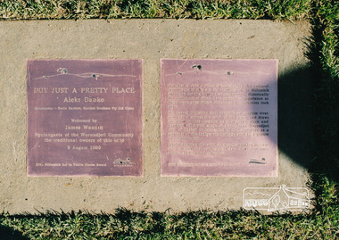
Photograph, Not Just a Pretty Place, Aleks Danko (2000), Lennister Farm, Eltham South, 2000c
Not Just a Pretty Place acknowledges the cultural significance of this site for the residents of Nillumbik Shire and for the Wurrundjeri community. Historically the confluence of rivers have particular importance as these were sites where rituals and ceremonies took place. The carved bluestone form presents an oversize river pebble that echoes the spirit of the water and draws attention to this location as a meeting place an landmark. Awarded the 2000 Nillumbik Art in Public Places Award and situated behind Lennister Farm near Yarra ParkColour photograph printaleks danko, eltham, lennister farm, yarra park -
 Eltham District Historical Society Inc
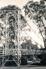
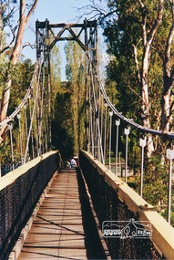
Photograph, Pedestrian suspension bridge over the Yarra River at Lower Plenty
Odyssey House drug rehabilitation centre in Bonds Road, Lower Plenty is a distinctive landmark, especially when viewed from across the Yarra at Templestowe. It was built in the 1950’s as a seminary for the Blessed Sacrament Fathers. Because of the poor and circuitous road access, a suspension footbridge was built across the river. As well as providing easy access for the priests residents of Templestowe could attend services at the seminary. The bridge is now part of the Yarra Trails system.Two black and white photographs of footbridge over Yarra River, part of the Ruffey Trail just off the Main Yarra Trail near the former seminary (now Odyssey House) Lower Plentybridges, yarra river, odyssey house, bonds road, lower plenty, seminary, blessed sacrament fathers -
 Eltham District Historical Society Inc
Photograph, Pedestrian suspension bridge over the Yarra River at Lower Plenty
Odyssey House drug rehabilitation centre in Bonds Road, Lower Plenty is a distinctive landmark, especially when viewed from across the Yarra at Templestowe. It was built in the 1950’s as a seminary for the Blessed Sacrament Fathers. Because of the poor and circuitous road access, a suspension footbridge was built across the river. As well as providing easy access for the priests residents of Templestowe could attend services at the seminary. The bridge is now part of the Yarra Trails system.Colour photograph of footbridge over Yarra River, part of the Ruffey Trail just off the Main Yarra Trail near the former seminary (now Odyssey House) Lower Plentybridges, yarra river, lower plenty, seminary, blessed sacrament fathers, odyssey house, bonds road -
 Eltham District Historical Society Inc
Photograph, Old Warrandyte Bridge
... melbourne bridges yarra river warrandyte kangaroo ground road ...Postcard showing old timber trestle Warrandyte Bridge over Yarra Riverbridges, yarra river, warrandyte, kangaroo ground road -
 Eltham District Historical Society Inc
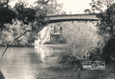
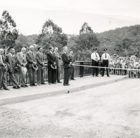
Photograph, Opening Warrandyte Bride, 8 Dec 1955
Built at a cost of £75,000 the five-span reinforced concrete bridge replaced the oldest bridge across the Yarra river, linking the Shire of Doncaster-Templestowe on the south bank with Eltham on the north. The bridge was opened by Mr. G. Reid, M.L.A.Three black and white photographsbridges, warrandyte, yarra river, councillors, ceremonies, stanley addison