Showing 15582 items
matching stillwell-valley
-
 The Beechworth Burke Museum
Photograph, Unknown c.1930s
This image shows Bethanga Bridge, which was constructed between 1927 and 1930 in Albury, NSW. The bridge was a necessity due to the building of the Hume Dam (Wier), 1919-1936. Bethanga Bridge is a long, nine-span, riveted-steel, variable depth, Pratt Truss road bridge of nine principal spans of 82 metres and a total length of 752 metres over the flooded valley of the Murray River, now part of Hume Reservoir. Because of its unique location, over the waters of a dam with the border running down the centre of the body of water, the Bethanga bridge is the only built structure shared by both New South Wales and Victoria. It was built 1.6 kilometres upstream of the dam and in 1961 was raised 300mm, with a concrete deck replacing the original wooden deck. The State Rivers and Water Supply Commission of Victoria and the New South Wales Department of Public Works were responsible for the construction works for the Hume Weir under the River Murray Waters Agreement. It is apparent that a similar joint arrangement was made for the construction of the Bethanga Bridge as part of the Hume Weir works.This photograph of the Bethanga Bridge is of historical significance as it showcases the architectural skills of Percy Allen and Vincent Packer. Additionally, it reveals the environmental landscape of the 1920s-1930s, is linked to the Hume Dam and both New South Wales and Victorian heritage. Unmounted black and white rectangular photograph. Reverse: 1997.3196 84-20-3bethanga, bethanga bridge, hume dam, pratt truss, murray river, hume weir, transportation -
 Eltham District Historical Society Inc
Document - Property Binder, 66 Susan Street, Eltham
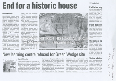
Newspaper clipping (photocopy/digital only): End for a historic house, Lyndal Reading, Diamond Valley Leader, February 1, 2006, p9Alistair Knox Park, Eltham, Eltham Skate Park A small cream cottage with green roof. The farmhouse built in the late 1800s by the Crozier Family. Subsequently owned by the Hill Family. Purchased in the early 1960s and by 1965 the property was owned by the Shire of Eltham. Employees of the Shire lived in the house. Susan Street originally ran all the way north of Bridge Street to the bend where it turned to the left into Brisbane Street. Today that section of Susan Street has been renamed as an extension of Brisbane Street. In 2006 the Shire of Nillumbik demolished the house which had been subject to extensive vandalism. In accordance with heritage advice and a permit condition a sign was placed on the site outlining the history of the building. This was installed and remained in place till about 2016 when it was removed. The land adjoins Alistair Knox Park. By 2010 the Eltham Skate Park was developed. In 2022 a major renovation and extension took place. Sources: EDHS Newsletter No 171 November 2006alistair knox park, eltham, eltham skate park, house, susan street -
 Eltham District Historical Society Inc
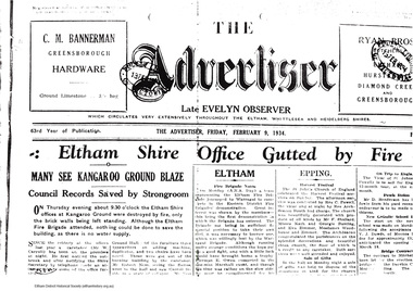
Folder, Eltham Shire Office Fire, 1934
Anecdotes about caretaker, Mr W. Carroll (Tiny), an old identity by H. Gillam, 1p History of records in office Fire, 1934 by Frank McMahon, 4p. Advertiser article 9/2/1934, Eltham Shire Office gutted by fire, 2p Advertiser article 16/2/1934, Eltham Shire Office post fire and early history as Evelyn Observer office, 2p Advertiser article 23/2/1934, Praise for Eltham Fire Brigade by Shire Secretary P.J.McMahon, 1p Extracts from "The Grass is Green" by Alan Marshall referencing Tiny Carroll, pp28-67 Recollections of Jocelyn McMahon (nee Shallard) on Office staff and conditions, 1928 to 1935,1p. Folder no 62 Photocopies of various newspaper articles from "The Advertiser", 1934 included in attached list. Typed transcription from "Diamond Valley News", 10 October, 1961 Includes copy of hand drawn map: "Kangaroo Ground, Parish of Nillumbik, Country of Evelyn, land holdings 1860s-1900s" with site of Eltham Shire Offices marked.Folder of photocopies, a transciption and typed up memoriesHG Booklets 8 and 62fire, reminiscences, tiny carroll, jocelyn mcmahon (nee shallard), harry gilham collection, eltham shire office, frank mcmahon, kangaroo ground, map, bill o'laughlin, cr jim ryan, evelyn observer, p.j. mcmahon, pelling, woodlands homestead -
 Greensborough Historical Society
Document - Document Collection, Local Council Representation Review, 2019_
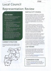
Contents: 2 x Newspaper Clippings: Banyule City Council Electoral Representative Review, Heidelberg Leader 20/08/2019 and Diamond Valley Leader 21/08/2019. Local Council Representative Review Submission Guide. Victorian Electoral Commission, 2019. 24 p., text. General information for those making a submission to a review. Local Council Representative Review Preliminary Report: Banyule City Council. Victorian Electoral Commission, August 2019. 31 p., text and colour maps. Reports on submissions and gives 3 options for electoral review in Banyule. Local Council Representative Review: Banyule City Council 1. Public hearing agenda and attachments. 25/09/2019. 9 p. 2. Public hearing agenda and attachments. 25/09/2019. 2 p. Agenda and handwritten notes by R. Bray. Local Council Representative Review Final Report: Banyule City Council. Victorian Electoral Commission, October 2019. 46 p., text and colour map. Recommends increasing the number of councillors and wards to 9. 2 newspaper clippings, 3 booklets and agenda with attachments. Filed in black plastic folder.banyule city council, victorian electoral commission, local council representative review 2019 -
 Kiewa Valley Historical Society
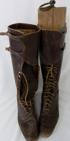
Boots Riding Women's, Circa 1950's
This pair of "adjustable" boots came from the 1950's era in which the majority of footwear was either locally manufactured or imported from England or Europe. Quality hard wearing leather was a rural necessity especially for the cattle mustering activity in the Kiewa Valley and the Bogong High Plains region. The late 1900's provided a cheaper made riding boot from Asia, however many rural based riders still prefer an Australian made boot. The better quality (stronger stitching) of Australian boots is the main considerations of "stock horse riders". In 1947 a scientific research project started to provide an impact analysis of any damage to alpine vegetation by cattle grazing in the Alpine regions incorporating the Bogong High Plains area. This monitoring is the longest running ecological study ever undertaken in Australia. From this study, compelling evidence was presented to the Victorian Government to cease cattle grazing in the Alpine regions including the Bogong High Plains. All grazing was banned by the Victorian Government in 2005. Recreational horse riding within the Bogong High Plains is still permitted.These pair of women's riding boots are very significant to the Kiewa Valley as the boots were worn by one of the descendants of a pioneer family living and operating a cattle station before the SEC Hydro Electricity Scheme opened up the semi remote rural location in the 1950's. These boots were worn during the annual six weeks (approx.) mustering of cattle in the Bogong High Plains location (Victorian Alps region). The owner of these boots was Clare Roper, part of the Roper Family who built a "lodging" hut on the "High Plains" for accommodating riders during the periods (up to six weeks) when controlling grazing cattle during the summer muster seasons. It was unusual for women in the early to mid 1900's to go up on the High Plains to join the muster, which Clare Roper often did. These boots have high historical significance and good interpretive capacity.These brown "knee high" lady riding boots, are fastened by long "boot" laces which go from the base of the "fastening" position to a boot height of 22 cm. At the top end of the boot is a leather flap which crosses the front section of the boot and is fastened to the outside leg region by two straps. These provide the wearer with an adjustable tie. The boot has a "tongue" of 22 mm long. The boot has six pairs of metal boot lace "hooks" and eight pairs of boot lace "eyelets".ladies riding boots. cattle mustering footwear. rural footwear. cattlemen. bogong high plains. roper family. horses. -
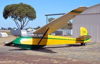 Australian Gliding Museum
Machine - Glider – Sailplane, 1957
The Alexander Schleicher K4 was designed in the mid 1950s by Rudolf Kaiser as a club training glider and several hundred were built. The Australian Gliding Museum’s K4, VH-IKK, serial number 55, was built in 1957 and purchased by the RAF Air Training Corp. U.K. After some years it was sold to a New Zealand Gliding Club and in 1990 with over 4800 hours, number of launches unknown, it was purchased by the Brisbane Valley Soaring Club and in 1994 was transferred to the Far North Queensland Soaring Centre who operated it from the Mareeba airfield. On 9 January 2000 it was donated to Vintage Gliders Australia by Kevin Sedgman at a presentation ceremony with Alan Patching receiving the glider during the Rally at Lake Keepit. It has been flown regularly at vintage glider rallies and on several occasions at Museum open days. However, it has subsequently been grounded on account of potential structural defects. VH-IKK is one of two K4s in Australia, the other being VH-XJP which is believed to be in storage in Queensland in a damaged condition. When restored, this exhibit will be representative example of the AS-K4 glider-sailplane type.Tandem two seat high wing strutted glider consisting of wood with plywood and fabric wings, tailplane / elevators, fin / rudder, and tubular steel framed, fabric covered fuselage. Prior to restoration work, the glider was finished in a white, green and yellow paint scheme. “Vintage Gliders Australia” name in white lettering on fuselage sides and registration VH-IKK in black lettering on rudderaustralian gliding, glider, sailplane, alexander schleicher, k4, kaiser, raf air training corp, brisbane valley soaring club, far north queensland soaring centre, vintage gliders australia, sedgman, patching -
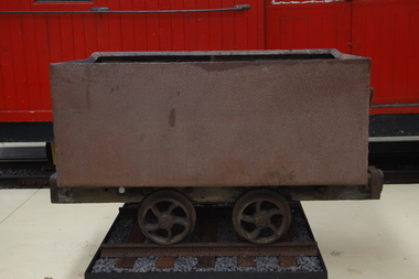 Puffing Billy Railway
Wonthaggi Coal Skip, Early 20th century
One of two types of four wheel skips widely used on the Wonthaggi Coal Fields for transportation from the underground workings to the surface screening and loading areas. Haulage underground was accomplished by the use of pit ponies, whilst an endless rope system was used to bring the skips to the surface areas. Much of the coal for the colony of Victoria was sourced from Newcastle and the Hunter Region in New South Wales, along with local supplies from private and co-operative coal mines at Outtrim, Jumbunna and Korumburra in Gippsland. After the 1909–1910 strike by coal miners in the Hunter Valley, the Victorian state government were determined to ensure stability in local supplies of coal. The State Coal Mine and the town of Wonthaggi came into being in 1910 to supply coal for the Victorian Railways. It was one of the largest and most dangerous collieries in Australia. At its peak in 1926 the mine produced 2,435 long tons (2,474 t) per day, with the Victorian Railways buying 90% of production. In 1928, Wonthaggi coal accounted for around 60% of Victorian Railways coal consumption.Historic - Industrial - Victorian Railways - Narrow Gauge Railway rolling stock - Wonthaggi Coal Fields, Victoria, AustraliaRectangular steel bin with wood frame and steel wheelspuffing billy, coal skip, wonthaggi, wonthaggi coal fields, 2'0" gauge, brown coal -
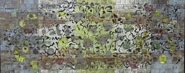 Nillumbik Shire Council
Public Art: Tom SANDERS (b.1925-d.2008 Vic, Aus), Tom Sanders, Wall of the Moon (Homage to Miro) - (Location: Eltham Town Square, Arthur Street, Eltham), 1968
Sanders was a well-known local potter who worked for a time with David Boyd at the Martin Boyd Pottery, before returning to Melbourne where he had some association with Arthur Boyd, at the pottery in Murrumbeena. Sanders set up a studio in Eltham in the early 1950s and made the first of a series of architectural ceramic murals with painter and print maker Lawrence Daws in 1956. In 1957 he left for Europe and while there was inspired by the Spanish artist Joan Miro’s unconventional painting style and large scale murals, in particular Wall of the Moon (1957). After returning from his travels in Europe to Australia in 1964, he began to work solely on creating ceramic murals, some of which were commissioned for Southland Shopping Centre in Cheltenham, Melbourne, 1968 (now demolished), the National Mutual Centre, Melbourne,1964-5 (now demolished), Dee Why Library, Sydney 1966, Woden Valley High School, ACT, 1967, Tullamarine Airport Melbourne, 1969-70 (now demolished), Perth Concert Hall, 1971 and The University of Melbourne,1975 (with John Olsen). This mural is one of only three remaining in the public realm by Tom Sanders (the others are at the Perth Concert Hall (1971) and at the University of Melbourne (1975). Ceramic mural (earthenware tiles) consisting of a playful/organic abstract design similar in style to the Spanish artist Joan Miro. Shades of blue, yellow and black glazes are layered onto matte black and shiny bronze tiles. N/Amural, public art, earthernware, pottery, ceramics, glaze, eltham, ekphrasis2017, eltham town square, joan miro -
 Whittlesea Historical Society Inc.
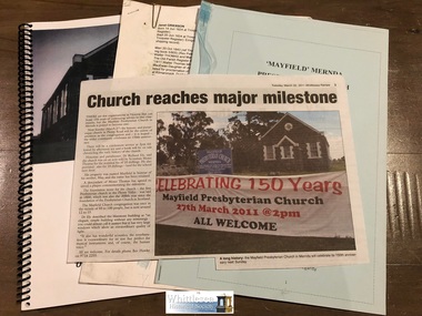
Memorabilia - paper, Mayfield Presbyterian Church, Mernda, 150 years Anniversary Memorabilia
The Mayfield Presbyterian Church at Mernda was erected in 1860, and the first service held on 23 October that year. The erection of the Mayfield Church, and others at Janefield and Whittlesea soon after, reflected the relatively large number of Scots in the Plenty Valley in the 1850s. Mayfield Church was built on an acre of land, apparently donated by Moses Thomas. It is not clear who designed and built the Mayfield Church, although it has been generally accepted that it was Moses Thomas. For a short time the newly completed church was called the Guthrie Church, after the prominent Scottish Free Church Leader. Moses Thomas died in 1878. His son Walter, who had joined him on the church committee in 1861, served on it almost until his death in 1932, having been ordained as an Elder in about 1880. Mayfield Church is the earliest of the five Presbyterian Churches in the City of Whittlesea, predating Kalkallo (1860), Whittlesea (1863), Mill Park (1861) and Epping (1867). (Ref: CITY OF WHITTLESEA HERITAGE STUDY © 1990 Meredith Gould Architects Pty Ltd)Mayfield Presbyterian Church, Mernda, 150 years Anniversary Memorabilia, containing 1 Draft copy of a book titled Mayfield Presbyterian Church, Mernda, Origins and Early Years, by Dr. Richard Ely, 1 Order of Service booklet, 1 newspaper article, 1 family history of the Moses Thomas family of Mernda.mayfield presbyterian church, mernda, moses thomas -
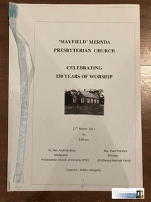 Whittlesea Historical Society Inc.
Memorabilia - paper, Mayfield Presbyterian Church, Mernda, 150 years Anniversary Memorabilia
The Mayfield Presbyterian Church at Mernda was erected in 1860, and the first service held on 23 October that year. The erection of the Mayfield Church, and others at Janefield and Whittlesea soon after, reflected the relatively large number of Scots in the Plenty Valley in the 1850s. Mayfield Church was built on an acre of land, apparently donated by Moses Thomas. It is not clear who designed and built the Mayfield Church, although it has been generally accepted that it was Moses Thomas. For a short time the newly completed church was called the Guthrie Church, after the prominent Scottish Free Church Leader. Moses Thomas died in 1878. His son Walter, who had joined him on the church committee in 1861, served on it almost until his death in 1932, having been ordained as an Elder in about 1880. Mayfield Church is the earliest of the five Presbyterian Churches in the City of Whittlesea, predating Kalkallo (1860), Whittlesea (1863), Mill Park (1861) and Epping (1867). (Ref: CITY OF WHITTLESEA HERITAGE STUDY © 1990 Meredith Gould Architects Pty Ltd)Mayfield Presbyterian Church, Mernda, 150 years Anniversary Memorabilia, containing 1 Order of Service booklet printed on blue paper with blue ribbon attached to the cover, 8 pages fixed with staplesMayfield Mernda Presbyterian Church Celebrating 150 Years of Worship, 27th March 2011mayfield presbyterian church, mernda, moses thomas -
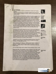 Whittlesea Historical Society Inc.
Memorabilia - paper, Mayfield Presbyterian Church, Mernda, 150 years Anniversary Memorabilia
The Mayfield Presbyterian Church at Mernda was erected in 1860, and the first service held on 23 October that year. The erection of the Mayfield Church, and others at Janefield and Whittlesea soon after, reflected the relatively large number of Scots in the Plenty Valley in the 1850s. Mayfield Church was built on an acre of land, apparently donated by Moses Thomas. It is not clear who designed and built the Mayfield Church, although it has been generally accepted that it was Moses Thomas. For a short time the newly completed church was called the Guthrie Church, after the prominent Scottish Free Church Leader. Moses Thomas died in 1878. His son Walter, who had joined him on the church committee in 1861, served on it almost until his death in 1932, having been ordained as an Elder in about 1880. Mayfield Church is the earliest of the five Presbyterian Churches in the City of Whittlesea, predating Kalkallo (1860), Whittlesea (1863), Mill Park (1861) and Epping (1867). (Ref: CITY OF WHITTLESEA HERITAGE STUDY © 1990 Meredith Gould Architects Pty Ltd)Mayfield Presbyterian Church, Mernda, 150 years Anniversary Memorabilia, containing a typed copy of family history of Moses Thomas and his wife Janet nee Grierson, typed copy of Moses Thomas's will, typed copy of Countrymindness and the democratic intellect: permutations and combinations in a Victorian country state school, 1853 to 2007mayfield presbyterian church, mernda, moses thomas -
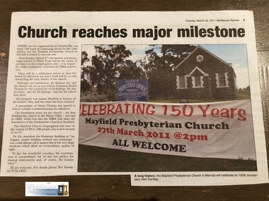 Whittlesea Historical Society Inc.
Memorabilia - paper, Mayfield Presbyterian Church, Mernda, 150 years Anniversary Memorabilia
The Mayfield Presbyterian Church at Mernda was erected in 1860, and the first service held on 23 October that year. The erection of the Mayfield Church, and others at Janefield and Whittlesea soon after, reflected the relatively large number of Scots in the Plenty Valley in the 1850s. Mayfield Church was built on an acre of land, apparently donated by Moses Thomas. It is not clear who designed and built the Mayfield Church, although it has been generally accepted that it was Moses Thomas. For a short time the newly completed church was called the Guthrie Church, after the prominent Scottish Free Church Leader. Moses Thomas died in 1878. His son Walter, who had joined him on the church committee in 1861, served on it almost until his death in 1932, having been ordained as an Elder in about 1880. Mayfield Church is the earliest of the five Presbyterian Churches in the City of Whittlesea, predating Kalkallo (1860), Whittlesea (1863), Mill Park (1861) and Epping (1867). (Ref: CITY OF WHITTLESEA HERITAGE STUDY © 1990 Meredith Gould Architects Pty Ltd)Mayfield Presbyterian Church, Mernda, 150 years Anniversary Memorabilia, containing 1 newspaper article from Whittlesea Review dated 22 March 2011mayfield presbyterian church, mernda, moses thomas, 150 anniversary -
 National Wool Museum
Work on paper - Women's Opening/Closing Ceremony Uniform Design Drawings, Wendy Powitt, c. 1992
A set of laminated A3 sketchbook pages depicting designs for the 1992 Barcelona Olympic Women's Opening/Closing Ceremony Uniform designed by Wendy Powitt. On the 1992 Barcelona Olympic Games donor Doug Pleasance wrote- The 1992 Barcelona Olympic Games saw an evolutionary change in designer selection. A Declaration of Interest Form was communicated to over forty potential designers. The task and especially tight timelines that were involved deterred many aspirants, however, there remained eight designers with the potential we were seeking. These eight designers were paid $3,000 per submission and the winning designer, Wendy Powitt, was paid $15,000. For the first time the judging panel included two athletes, one male swimmer and one female basketballer, their influence was pivotal. Opening Ceremony Uniform included a lightweight wool fabric printed with floral designs that had been inspired by the work of Australian artist Margaret Preston. This included: Lightweight W/PE shorts by Fletcher Jones in Foster Valley Fabric, socks by Holeproof and footwear by Hush Puppy.8120.1 - A laminated A3 sketchbook page depicting a design for the 1992 Barcelona Olympic Women's Opening/Closing Ceremony Uniform. The main drawing shows the design for a dark green skirt, a yellow printed sleeveless button up shirt, a matching headband and scarf, yellow gloves and brown leather shoes. To the right of the main image are five detail drawings of the skirt, gloves, shoes and scarf as well as a depiction of a brown leather bag. 8120.2 - unnumbered- mounted on green card this sketchbook page depicts a design for the 1992 Barcelona Olympic Women's Opening/Closing Ceremony Uniform. The main drawing shows the design for a dark green skirt, a yellow printed sleeveless button up shirt and yellow gloves. 8120.3 - unnumbered- A laminated A3 sketchbook page depicting a design for the 1992 Barcelona Olympic Women's Opening/Closing Ceremony Uniform. The main drawing shows the design for a dark green skirt, a yellow printed sleeveless button up shirt, a matching headband and scarf, yellow gloves and brown leather shoes. To the right of the main image are five detail drawings of the skirt, gloves, shoes and scarf as well as a depiction of a brown leather bag.1992 barcelona olympics, sport, athletes, fashion, design, artwork, drawing, uniform -
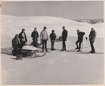 Falls Creek Historical Society
Photograph - Snowmobiles on Spion Kopje, c1970
Julian Newton Brown arrived at Falls Creek in 1957. He had studied Pharmacy at Melbourne University. After developing a love for the mountains, Julian moved to Mt. Beauty and then Falls Creek. He worked for the SEC in the test laboratory at Rocky Valley reading weather instruments. By working several jobs, Julian was able to build a small lodge of 10 beds named “Arundel”, located at 18 Slalom Street, Falls Creek. The lodge is now the “Elk at Falls”. Arundel prospered and Julian extended it to include 32 beds and changed its name to "Julian’s” in 1961. When alcohol restrictions were eased in Falls Creek, Julian built a night club which he called “Big Julian’s” and later “THE MAN”. When Julian and his wife Beth retired and left Falls Creek, their son took over running the lodge. An active community man, Julian was a member of the Falls Creek Chamber of Commerce, a member of the SES, a stakeholder in Falls Creek, an author and a documentary maker. Julian Newton-Brown died in May 2020.This image is significant because it includes a prominent Falls Creek businessman and community member.A black and white image of a group of skiers and an early snowmobile on Spion Kopje, Left to Right:- Jim Flanagan, Julian Newton Brown, Bill Bridgford, unknown, Sun Newspaper Journalist, Pat Rauter, Geoff Henke, Rob Wardjulian newton brown, spion kopje, snowmobiles on falls creek -
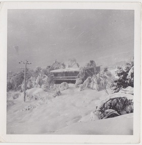 Falls Creek Historical Society
Photograph - Arundel Lodge
Arundel was built by Julian Newton-Brown who arrived at Falls Creek in 1957. He had studied Pharmacy at Melbourne University. After developing a love for the mountains, Julian moved to Mt. Beauty and then Falls Creek. He worked for the SEC in the test laboratory at Rocky Valley reading weather instruments. By working several jobs, Julian was able to build a small lodge of 10 beds named “Arundel”, located at 18 Slalom Street, Falls Creek. The lodge is now the “Elk at Falls”. Arundel prospered and Julian extended it to include 32 beds and changed its name to "Julian’s” in 1961. When alcohol restrictions were eased in Falls Creek, Julian built a night club which he called “Big Julian’s” and later “THE MAN”. When Julian and his wife Beth retired and left Falls Creek, their son took over running the lodge. An active community man, Julian was a member of the Falls Creek Chamber of Commerce, a member of the SES, a stakeholder in Falls Creek, an author and a documentary maker. Julian Newton-Brown died in May 2020.This item is significant because the lodge was built by a prominent Falls Creek businessman who was a pioneer and dedicated member of the Falls Creek community.Three black and white photographs showing different aspects of Arundel Lodgejulian newton brown, arundel, the man, big julians falls creek -
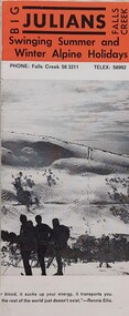 Falls Creek Historical Society
Booklet - Big Julians Falls Creek, 1973
Julian Newton Brown arrived at Falls Creek in 1957. He had studied Pharmacy at Melbourne University. After developing a love for the mountains, Julian moved to Mt. Beauty and then Falls Creek. He worked for the SEC in the test laboratory at Rocky Valley reading weather instruments. By working several jobs, Julian was able to build a small lodge of 10 beds named “Arundel”, located at 18 Slalom Street, Falls Creek. The lodge is now the “Elk at Falls”. Arundel prospered and Julian extended it to include 32 beds and changed its name to ‘Julian’s” in 1961. When alcohol restrictions were eased in Falls Creek, Julian built a night club which he called “Big Julian’s” and later “THE MAN”. When Julian and his wife Beth retired and left Falls Creek, their son took over running the lodge. An active community man, Julian was a member of the Falls Creek Chamber of Commerce, a member of the SES, a stakeholder in Falls Creek, an author and a documentary maker. Julian Newton-Brown died in May 2020.This brochure is important because it documents an establishment operated by a highly regarded pioneer and businessman of Falls Creek.A brochure printed on glossy paper, featuring information and images. On Cover: BIG JULIANS FALLS CREEK Swinging Summer and Winter Alpine Holidays PHONE: Falls Creek 58 3211 TELEX:v56992accommodation falls creek, big julians falls creek, julian newton-brown -
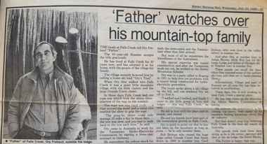 Falls Creek Historical Society
Article - "Father" watches over his mountain-top family, 30 July 1986
This article acknowledged the naming of Ory's Trail at Falls Creek in 1986. Orest “Ory” Frueauf was born in Kharkov, Russia in 1925 and moved to Germany with his family to escape persecution. He was conscripted to the German Army during the Second World War. He was a POW until 1948. He was recruited by a French construction company to work as and interpreter on a hydroelectricity project in Tasmania. Ory then moved to work on the Snowy Mountain Scheme including driving a truck to fill the wall of the Rocky Valley dam. In 1952 Ory was recruited by the Albury Ski Club as its lodge supervisor. That year he also entered into a business partnership with Cecil Dobson, running the general store “Whitehaven” and Post Office at Falls Creek. They extended their business by adding accommodation turning Whitehaven into one of the best commercial lodges at Falls Creek. Ory and Cecil dissolved their business partnership in 1963 and Ory went on to build a new lodge called “Snowhaven” at the site of the present day Frueauf Village, Falls Creek. Ory retired to Tawonga, Victoria in 1992 and passed away in 1999.This article is significant because it documents the naming of Ory's Trail to recognise a pioneer of Falls Creek.A newspaper item about Ory Freauf on the occasion of the naming of Ory's Trail at Falls Creek.falls creek pioneers, frueauf, ory frueauf -
 Falls Creek Historical Society
Map - Falls Creek Alpine Resort Map
Julian Newton-Brown arrived at Falls Creek in 1957. He had studied Pharmacy at Melbourne University. After developing a love for the mountains, Julian moved to Mt. Beauty and then Falls Creek. He worked for the SEC in the test laboratory at Rocky Valley reading weather instruments. By working several jobs, Julian was able to build a small lodge of 10 beds named “Arundel”, located at 18 Slalom Street, Falls Creek. The lodge is now the “Elk at Falls”. Arundel prospered and Julian extended it to include 32 beds and changed its name to "Julian’s” in 1961. When alcohol restrictions were eased in Falls Creek, Julian built a night club which he called “Big Julian’s” and later “THE MAN”. When Julian and his wife Beth retired and left Falls Creek, their son took over running the lodge. An active community man, Julian was a member of the Falls Creek Chamber of Commerce, a member of the SES, a stakeholder in Falls Creek, an author and a documentary maker. Julian Newton-Brown died in May 2020.This map is significant because it contains an image of Falls Creek Alpine Resort.A black and white map of Falls Creek Alpine Resort Map featuring a photo taken by Julian Newton Brown. A numbered legend is included at the bottom right corner.dawn ski club, accommodation falls creek, lodges falls creek, tom mitchell -
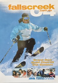 Falls Creek Historical Society
Booklet - Falls Creek Information 2004
This publication was a major item in the Falls Creek marketing program for 2004. A major feature of 2004 winter season was the opening of Drover’s Dream, arguably Australia’s most picturesque chairlift. Taking over from Panorama Poma, the new four-seat high-speed chairlift would open up more top to bottom riding. This was a multi-million dollar resort investment and expanded the Sun Valley area. It was over 700 metres long and added an additional 7.4 hectares of beginner and intermediate terrain. It was predicted to reduce queues on the Towers Chairlift as it had a capacity of 2,400 riders per hour. XC Skiing was strongly promoted including Cross-Country Trail Passes, Lessons and Ski Hire available from Falls Creek Nordic Hire at Windy Corner, Gebi’s Ski Hire, Viking Ski Hire and Koki Ski Hire. Accommodation rates for 43 different venues were included. Corporate Partners in 2004 were Bilia Volvo, Nursing Australia, Milo and Ten TV, with Hewlett Packard sponsor of the Falls Creek Racing and Events Department.This booklet is significant because it documents seasonal activities at Falls Creek in 2004 and the opening of the Drover's Dream Chairlift.A glossy publication of 40 pages promoting Falls Creek all year round. It includes detailed information of activities at Falls Creek, images and advertising,falls creek activities 2004, drover's dream falls creek, falls creek marketing -
 Bendigo Historical Society Inc.
Document - AUCTION SALES - MINING CATALOGUE AUCTION SALES
Yellow and white patterned, spring back Spirax Students No. 594 Note Book containing extracts from mining Catalogues loaned by Mr. Dyett (J. H. Curnow's). Mines mentioned include Ramrod Gold Mine, Hercules No. 1, Central Blue, South Virginia Extended, Alfords Battery, South New Moon,The Gold Mine Clunes, Guildford Plateau, Big Blue, Spring Gully Mine at Chewton, Eureka Central at Chewton, Bdgo Amalg. Goldfields Limited, Koch's Air Station, Cornish Mine, Carlisle Battery, Victory & Pandora Mine, Garden Gully, Londonderry Mine, Princess Dagmar, Golden Age, Suffolk United, Virginia South Extended, South Red White & Blue, Pitfield Plains Glenfine South Shaft, Adelong Dredge & Leases, Bright Valley Dredge, North Chewton (Chewton), Talbot Alluvials Norbury's No. 2 Shaft, Gordon Gold Mine Inglewood, Post Office Hill Mine Chewton, Carlisle & Whittaker Plant Maldon, Bunninyong, Yandoit Mine, North Chewton, Golden Transverse Bdgo, Yandoit Co., Chapman's Gold Mine Chewton, Ross Creek Extended G. M. Coy (Ballarat).book, bendigo, mining auction sales, auction sales mining catalogue auction sales, j h curnow, mr dyett, a richardson, ramrod gold mine, hercules no. 1, central blue, south virginia extended, alfords battery, south new moon, the gold mine clunes, guildford plateau, big blue, spring gully mine at chewton, eureka central at chewton, bdgo amalg. goldfields limited, koch's air station, cornish mine, carlisle battery, victory & pandora mine, garden gully, londonderry mine, princess dagmar, golden age, suffolk united, virginia south extended, south red white & blue, pitfield plains glenfine south shaft, adelong dredge & leases, bright valley dredge, north chewton (chewton), talbot alluvials norbury's no. 2 shaft, gordon gold mine inglewood, post office hill mine chewton, carlisle & whittaker plant maldon, bunninyong, yandoit mine, north chewton, golden transverse bdgo, yandoit co., chapman's gold mine chewton, ross creek extended g. m. coy (ballarat). -
Southern Sherbrooke Historical Society Inc.
Typescript|Photograph - copy
Single page typescript composed by Jill A'Vard, and single page with four copies of photographs. -Micawber Park Picnic Ground Belgrave c. 1934 shows a forest scene, a creek with a large tree fallen across it, a wooden footbridge, and a man in a hat standing on the bridge. Black and white photo. -Micawber Tea Rooms Belgrave shows a group of two men and two women standing on the verandah of a building which bears the signs "Refreshments", "Hot water" and "Micawber Tea Rooms". Black and white photo. -Ted & Lil A'Vard sitting in their lounge room at Micawber Park c. 1935 shows a middle-aged couple in armchairs in front of a brick fireplace. The mantelpiece holds several items including a clock. Behind the woman, on the right side, is a wooden stand with a green vase holding an arrangement of autumn-coloured flowers and foliage. The man is holding a book and there is possibly a dark dog at the woman's feet. Black and white photo which has been coloured in the top right corner (flower vase and edge of mantelpiece). -Alf & Maggie A'Vard's "The Valley" is a Rose Series postcard P. 1488, showing a house in a forest setting with a group of people on the verandah.albert a'vard, a'vard family, micawber park, alf a'vard, the valley -
 Kiewa Valley Historical Society
Ron White's Collection - 1920 - 2019
Ron White was born in 1920. He received a Diploma of Mechanical Engineering at Footscray Technical School in 1946. He started work as a laboratory assistant and after several promotions was appointed Senior Operator in 1948. In 1949, he was Engineer, Grade 1 (Hydro Areas). After further promotions he became Assistant Area Engineer, Rubicon at new Eildon Power Station and Area Engineer, Kiewa in commissioning Mt Beauty Terminal Station and West Kiewa Power Station.. By 1956, he was the Area Operations Engineer at Kiewa and four years later the Kiewa Electrical Superintendent (Operations and Maintenance) . In 1961, he was officially recognised as deputy for the General Superintendent, Kiewa. In 1966 he was appointed General Superintendent Kiewa and Kiewa became 'a branch of the Transmission Department'. In 1974, the Rubicon / Eildon Area was also under Ron's control. His title was "Principal Hydro Engineer, Hydro Division, Transmission Operations Department. He held this position until his retirement in 1985.Ron White was an important identity in his role as Principal Hydro Engineer from 1966 to 1985 after the completion of the Kiewa Hydro Electric Scheme. His long period of service involved him in the construction, operation and maintenance of the SECV's Hydro Electric Schemes and administration of related catchment areas. He had a close association with the local communities and care for the welfare of employees. He lived in Mt Beauty and was well respected in the community and beyond. He passed away on 30 September 2019, aged 99 years.A) History of Ron White's Working Life: including papers relating to "Promotion & Staff Appointment" B) Ron White's Retirement - 11th Jan. 1985: papers, cards, letters, photos, disc/plaque C) Ron White's Certificates: Diploma of Mechanical Engineering; First Aid; D) Ron White's Correspondence - miscellaneous E) Ron White's History of the 'Kiewa Scheme' from 1936- 1966. Written 1986 F) Ron White's Photo album Includes photos of him and the 2003 bushfires G) Miscellaneous Photos (not labelled) from Ron's photo album. Possibly relatives including nieces and nephews. H) Pewter Mug presented to Ron - Water Board I) Wall hanging presented to Ron - Scouts J) Ron White's Slide Ruler & Mathematical Instruments K) Collection of 7 books owned by Ron L) Starting Pistol Caps box M) Ice-cream serverF) One photo of Ron with 'Ken Connors'. One photo with 'l to r: Norm Middleton, Graham Napier, Ron White, Les Peart.' G) 2003 fires has a note re time, date and whereabouts of fires H) "Presented To / Ron White / In Appreciation For Service / To The / Kiewa Valley / Water Authority / And / Its predecessor Bodies / December 1994 I) Wall hanging: On emblem - "Lord Baden-Powell Society / The Scout Association of Australia". On Name Plate below - Ronald K. White 1989" J) mathematical Instruments have 'R. W' embossed in red on the corner of the cover M) 100 Straitline, Starting Pistol Caps N) National Ice-cream Server with stainless steel spring Size 20 ron white, hydro engineer, kiewa hydro electric scheme -
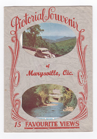 Marysville & District Historical Society
Postcard (item) - Colour and black and white photographs, Murray Views, Pictorial Souvenur of Marysville, Vic. 15 Favourite Views, 1950's
A fold out postcard of 15 colour and black and white photographs of scenes and landscapes in and around Marysville in Victoria.A fold out postcard of 15 colour and black and white photographs of scenes and landscapes in and around Marysville in Victoria. These photographs were produced by Murray Views in Gympie, Queensland as a souvenir of Marysville.Pictorial Souvenir/ of/ Marysville, Vic./ 15 Favourite Views PRODUCED BY MURRAY VIEWS. GYMPIE. Q. COPYRIGHT SAMUEL LEE & CO., PRINTERS Serial No. R 4152 NICHOLL'S LOOKOUT, MARYSVILLE, VIC. TAGGERTY RIVER, MARYSVILLE, VIC ROAD SCENE, MARYSVILLE, VIC. MAIN STREET, MARYSVILLE, VIC. THE CROSSWAYS, MARYSVILLE, VIC. FRUIT SALAD FARM, MARYSVILLE, VIC. ROAD TO CUMBERLAND VALLEY, MARYSVILLE, VIC. CROSSWAYS CABARET, MARYSVILLE, VIC. TREE FERNS, MARYSVILLE, VIC. STEVENSON'S FALLS, MARYSVILLE, VIC. Looking towards Marysville, Vic. Tourists at Marysville, Vic. Taggerty River, Marysville, Vic. On Buxton Road, Marysville, Vic. Panorama from Black Spur, Marysville Road, Marysville, Vic.marysville, victoria, souvenir, postcard, nicholl's lookout (image 1), taggerty river (image 2), road scene (image 3), main street marysville (image 4), crossways hotel (image 5), fruit salad farm (image 6), cumberland valley (image 7), crossways cabaret (image 8), tree ferns (image 9), steavenson falls (image 10), marysville view (image 11), tourists marysville (image 12), taggerty river (image 13), buxton road (image 14), black spur (image 15) -
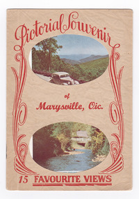 Marysville & District Historical Society
Postcard (item) - Colour and black and white photographs, Pictorial Souvenir of Marysville, Vic. 15 Favourite Views, Unknown
A fold out postcard of 15 colour and black and white photographs of scenes and landscapes in and around Marysville in Victoria.A fold out postcard of 15 colour and black and white photographs of scenes and landscapes in and around Marysville in Victoria. These photographs were produced by Murray Views in Gympie, Queensland as a souvenir of Marysville.Pictorial Souvenir/ of/ Marysville, Vic./ 15 Favourite Views PRODUCED BY MURRAY VIEWS. GYMPIE. Q. COPYRIGHT SAMUEL LEE & CO., PRINTERS Serial No. R 4152 NICHOLL'S LOOKOUT, MARYSVILLE, VIC. TAGGERTY RIVER, MARYSVILLE, VIC ROAD SCENE, MARYSVILLE, VIC. MAIN STREET, MARYSVILLE, VIC. THE CROSSWAYS, MARYSVILLE, VIC. FRUIT SALAD FARM, MARYSVILLE, VIC. ROAD TO CUMBERLAND VALLEY, MARYSVILLE, VIC. CROSSWAYS CABARET, MARYSVILLE, VIC. TREE FERNS, MARYSVILLE, VIC. STEVENSON'S FALLS, MARYSVILLE, VIC. Looking towards Marysville, Vic. Tourists at Marysville, Vic. Taggerty River, Marysville, Vic. On Buxton Road, Marysville, Vic. Panorama from Black Spur, Marysville Road, Marysville, Vic.marysville, victoria, souvenir, postcard, nicholl's lookout (image 1), taggerty river (image 2), road scene (image 3), main street marysville (image 4), crossways hotel (image 5), fruit salad farm (image 6), cumberland valley (image 7), crossways cabaret (image 8), tree ferns (image 9), steavenson falls (image 10), marysville view (image 11), tourists marysville (image 12), taggerty river (image 13), buxton road (image 14), black spur (image 15) -
 Eltham District Historical Society Inc
Folder, Personal papers of Stanley Simpson Addison M.B.E
Contents: Eltham War Memorial Trust, Official Opening - Baby Health Centre, 15th November, 1952; Timetable of proceedings Eltham Baby Health Centre; Official Opening - Baby Health Centre: Address by President, 15 November 1952 Program; Eltham War Memorial Trust: Opening of the Second Unit of the War memorial, The Pre-school Centre, on Saturday, December 1st, 1956 at 3 p.m. Eltham War Memorial: Address by Mrs Stanley Addison at the Annual Meeting of the Infant Welfare Centre, Thursday 21st October, 1965 Newspaper clipping: Infant Welfare Centre as War Memorial, 15 November 1952 Newspaper clipping: Eltham War Memorial Trust by Stanley Addison, 1953 Newspaper clipping: Eltham: Memorial Baby Health Centre Opening Newspaper clipping: Minister to open Eltham Pre-school Tomorrow Newspaper clipping: War Memorial Trust Who is this man? By Stanley Addison (M.B.E., B.A., B.Sc., J.P.) Stanley Simpson Addison biography (b. 14/10/1880 d. 1/1/1972) Eulogy: Stanley Simpson Addison (14 Oct 1880-1 Jan 1972) Photograph: Stanley S. Addison, B.Sc., The Australasian Intercollegian, April 1, 1916 Letter, Eltham High School Advisory Committee re pending retirement of Cr. Addison from the Eltham Shire Council, 8 June 1956 Behind and Before by Stanley S. Addison, The Way, September 1956, pp 6-7 Newspaper clipping: Eltham Shire's President is Cr. S. Addison, Heidelberg News, Friday September 12, 1952 Newspaper clipping: Mr S. Addison Honored, Heidelberg News, Friday September 21st, 1956, p13 Additional information about Stanley Simpson Addison from Bill Glasson, 15 March 2014 Additional information about Stanley Simpson Addison's Naval Service record and MBE (National Archives) Opening of Lower Plenty Memorial Chapel, 30 November 1952 Letter from Brigadier H.H. Hammer, HQ 2 Armed Brigade to Cr. S. Addison, President, Shire of Eltham giving thanks for Coronation Celebrations parade support, June 1953 Newspaper clipping: Eltham President's Advance Programme Newspaper clipping: Coronation Festivities; Eltham Shire President's Notes Newspaper clipping: Hurstbridge: Coronation Day Ceremony Draft of letter by Stanley S. Addison, President, Kangaroo Ground Advancement League regarding electricity connection for Kangaroo Ground - Panton Hill, 1954 Electricity connection, Kangaroo Ground - Panton Hill, 1954 Electricity connection, Kangaroo Ground - Panton Hill, 1955 Newspaper clipping: Light for Diamond Valley; Kangaroo Ground and Panton Hill, Friday 20th May, 1955 Electricity connection, Kangaroo Ground - Panton Hill, 1955 Electricity connection, Kangaroo Ground - Panton Hill, 1956 Electricity connection, Panton Hill - Smitrhs Gully, 1958 100th Anniversary Services, Kangaroo Ground Presbyterian Church, 17 March 1957 Early History of Kangaroo Ground compiled by Neville Haughton in March, 1959 Newspaper clipping: Eltham Community Chest, Heidelberg News, 12 September 1958 Newspaper clipping: Proposed Eltham Community Chest by Stanley Addison, Heidelberg News, 29 January 1959 Newspaper clipping: Community Chest With Wider Objectives, Heidelberg News, 5 February 1959 Newspaper clipping: Community Chest for Eltham, 1959 Newspaper clipping: Council Protest on Community Chest, c.1959 Newspaper clipping: Community Chest Outlined at Small Meeting, c.1959 Newspaper clipping: Treasure in the Diamond Valley by Stanley Addison, Heidelberg News, 19 February 1959 Newspaper clipping: Diamond Valley Chamber of Commerce, c.1959 Approx. 89 pages of varying types; photocopies, newsclippings, hand written notes, invitations, lettersa.c. ring, a.s. davis, adult education, biography, brigadier h.h. hammer, centenary celebrations, coronation, d. dureau, d. scales, d.a. lyon, d.s. pepper, diamond creek, diamond valley chamber of commerce, diamond valley community hospital, electricity supply, eltham chamber of commerce, eltham community chest, eltham high school advisory committee, eltham high school, eltham infant welfare centre, eltham pre-school, eltham shire council, eltham war memorial trust, eulogy, f.f. durham, f.h. buckwell, f.v. squire, g.c. waring, g.w. smith, h. thompson, h.f. thorpe, j. north, j.l. ryan, j.r. stuber, j.w. burgoyne, j.w. middleton, k.w. smith, kangaroo ground advancement league, kangaroo ground presbyterian church, kangaroo ground, l.r. bassett, lower plenty memorial chapel, miss j. humphreys, montmorency girl guides, montmorency tennis club, montmorency, mrs. b. harrington, mrs. stanley addison, n.h. baxter, opening ceremony, panton hill, parade, r. t. harrap, r.s. leeson, s.a. hick, shire president, smiths gully, st faiths anglican church, stanley s addison collection, stanley simpson addison, stevenson family, vera addison (nee staley), vera addison, w. stephenson -
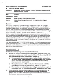
 Eltham District Historical Society Inc
Document - Property Binder, 907 Main Road, Eltham
Newspaper article: $6000 grant to Our Lady's, The Advertiser, July 2, 1996 - Grant given to Parish of Our LadyHelp of Christians which is taking over the use of the Eltham War Memorial Hall in Main Road and the Nillumbik After School Program. (Other items include: St Andrews Submission Re application to subdivide 1726 Heidelberg-Kinglake Road; Minister's decision awaited - A six-eight lot subdivision at Eagles Nest Road, Strathewen; Mt Pleasant Rd petition - Need for a shared pathway; Policy on ad signs - Amended policy on advertising signs for community events; Main Rd streetscape plan - Plans for streetscape improvement in Main Road to go on display; Special meeting dates set - Special meetings to consider formal submissions and then adopt a final proposal for Shire's electoral structure for Ministerial approval and gazettal. Letter Eltham District Historical Society to Nillumbik Shire Council, 16 September 1996: Proposed roundabouts Main Road Eltham at Dudley Street and Panther Place. Newspaper article: Diamond Valley News 16 October 1996, Pre-school welcomes plan for traffic lights.main road, eltham, property, roundabouts, dudley street, panther place, eltham pre-school, eltham war memorial -
 Eltham District Historical Society Inc
Book, Things You Didn't Know about the Railway: Eltham, Diamond Creek, Wattle Glen, Hurstbridge, 2017
Update of 1st editon by Jock Ryan published in March 2003. 2nd edition (Revised) Nillumbik Historical Society December 2017 Brief history of the agitation and eventual extension and opening of the Hurstbridge Railway line from Eltham to Diamond Creek, Wattle Glen to Hurstbridge, which was opened in June 1912. Includes details of events thereafter including Wattle Day and Railway accidents. Profusely illustrated with black and white photographs from the collection of the Nillumbik Historical Society (Diamond Creek). Agitation for a railway extension began in 1888 when a meeting was held at Arthurs Creek to press for the construction of a railway line from Heidelberg to Kinglake. The Chairman Mr Charles Draper said this was necessary because this was the best fruit growing district in Victoria. Mr Cameron M.P. pointed out that whatever route the line took it would have to follow the Diamond Valley from Eltham. At the same time another meeting was pressing for the line to be extended to Queenstown (St Andrews). However when detailed surveys were made it was discovered that the only possible route was to Hurstbridge because of the hills. In 1912 the railway was opened terminating at Hurstbridge. Bound with orange covers. Text with black and white illustrations. 30 pages.hurstbridge railway line,diamond creek,wattle glen,hurstbridge, nillumbik historical society -
 Eltham District Historical Society Inc
Folder, Shire of Eltham Living and Learning Centre, 1996
Contents: 1. Hand drawn schematic record of site buildings as of 1975 compiled by Harry Gilham, Shire of Eltham Historical Society 2. History compiled on the ocassion of the Eltham Living and Learning Centre's 21st birthday in 1996. Includes historical notes about the property, origins of the Living and Learning Centre at Eltham which started in 1975. List of associate groups, friends of the creek, friends of the centre, playhouse, list of co-ordinators 3. Enrolment Day Cake recipe 4. Poem - "Who'd be a co-ordinator" by unknown 5. Traditions and Memories by Margaret Johnson, Program Co-ordinator for 10 years 6. Reminiscences by Linda Kirkwright, Admin Assistant 7. In the beginning there was a small cottage ... by Joanne Osborne, Assistant Co-ordinator 1977-1980 8. Newsclippings - Living and Learning Centre in Council Centre, Diamond Valley New, 2 Apr 1975; 'Rub-A-Dub" unknown publication; and miscellaneous advertisements 9. Copy of certifcate of title when transferred to the Shire of Eltham in 1975 10. Copy of 1992 Shire of Eltham Heritage Study, pages 930-936 with notations 48 A4 pages photocopies HG Booklets 22 and 47, 64eltham living and learning centre, enrolment day cake, harry gilham collection, heritage study, history, joanne osborne, linda kirkwright, margaret johnson, poem, recipe, reminiscences, who'd be a co-ordinator -
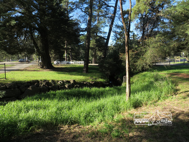
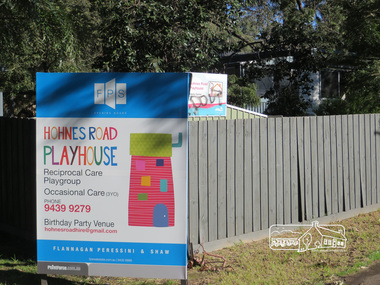 Eltham District Historical Society Inc
Photograph, Liz Pidgeon, Heritage Excursion; Eltham Lower Park Walk and Talk, 1 July 2017, 1 July 2017
Newsletter No., 234, June 2017 Heritage Excursion - Saturday 1st July - Eltham Lower Park - Walk and Talk Eltham Lower Park has played an important part in the history of our area since the early days of European settlement when it was used by local residents as an informal racecourse. Prior to that its location at the junction of the Diamond Creek and the Yarra River made it an important meeting place for the Wurundjeri people. The park combines formal elements and sporting facilities with remnant bushland that is of environmental significance. It is home to sporting and horse riding clubs, popular play spaces and the Diamond Valley Miniature Railway, which attracts large numbers of visitors. The park will be the venue for our July excursion which will comprise a walk of about 3.5 km around the park and adjacent areas. Along the way we will discuss the history and natural history of the area. The path along the creek and the river provides a pleasant and scenic walk. This walk on Saturday 1st July is about 3.5 km in length and will take 2 to 2.5 hours. It will start at 2pm at the Main Road car park at the front of the park. (Melway ref 21 H 10). Born Digitalheritage excursion, activities, eltham district historical society, eltham lower park, hohns road playhouse, sign -
 Eltham District Historical Society Inc
Photograph, Liz Pidgeon, Heritage Excursion; Eltham Lower Park Walk and Talk, 1 July 2017, 1 July 2017
Newsletter No., 234, June 2017 Heritage Excursion - Saturday 1st July - Eltham Lower Park - Walk and Talk Eltham Lower Park has played an important part in the history of our area since the early days of European settlement when it was used by local residents as an informal racecourse. Prior to that its location at the junction of the Diamond Creek and the Yarra River made it an important meeting place for the Wurundjeri people. The park combines formal elements and sporting facilities with remnant bushland that is of environmental significance. It is home to sporting and horse riding clubs, popular play spaces and the Diamond Valley Miniature Railway, which attracts large numbers of visitors. The park will be the venue for our July excursion which will comprise a walk of about 3.5 km around the park and adjacent areas. Along the way we will discuss the history and natural history of the area. The path along the creek and the river provides a pleasant and scenic walk. This walk on Saturday 1st July is about 3.5 km in length and will take 2 to 2.5 hours. It will start at 2pm at the Main Road car park at the front of the park. (Melway ref 21 H 10). Born Digitalheritage excursion, activities, eltham district historical society, eltham lower park, alcohol free zone, sign, grafitti