Showing 9110 items
matching e. [will]
-
 Kew Historical Society Inc
Document (item) - Invitation, City of Kew, Official Opening of the Glass Creek Kindergarten, 1956
The Municipality of Kew (1860-1863), the Borough of Kew (1863-1910), the Town of Kew (1910-1921) and the City of Kew (1921-1994) were local government instrumentalities in the State of Victoria. In 1994, the City of Kew was amalgamated, together with the former Cities of Camberwell and Hawthorn, into the new City of Boroondara (1994- ). Like other local government entities of the period, Kew was administered by town clerks. The two notable town clerks in Kew's history were H. H. (Henry Hirst) Harrison (1868-1955) and W. D. (William Dickie) Birrell (1899-1974). Harrison was appointed to the position in 1901 and retired in 1938 after 37 years. Birrell, appointed Acting Town Clerk in 1921, became Town Clerk in 1938, following Harrison's retirement. He continued in this role until his retirement in 1966.This card is part of an historically significant civic collection, containing hundreds of separate invitations, documents, greeting cards, programmes and tickets issued and/or collected by successive town clerks. Items in the collection illuminate the political, social and cultural history of the district. As a continuous record, ranging across most decades of the Twentieth Century, they reveal changing tastes in design, values and relationships in the history of local government in Victoria.CITY OF KEW / THE MAYOR, CR W A COMEADOW OBE JP / EXTENDS TO YOU A CORDIAL INVITATION TO BE PRESENT AT / OFFICIAL OPENING OF THE GLASS CREEK KINDERGARTEN / BY THE HON E P CAMERON MLC MINISTER OF HEALTH / WEDNEDSDAY 24TH OCTOBER, 1956, AT 2.45 P.M.civic invitations -- kew (vic), glass creek kindergarten -
 Falls Creek Historical Society
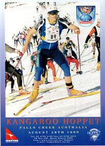
Poster - Kangaroo Hoppet 1999
The Kangaroo Hoppet is Australia’s premier long distance cross country ski race, and a member of the Worldloppet series of international cross country ski events. The first race at Falls Creek was held in 1979 under the name of “Australian Birkebeiner”. It was a 21km race with about 80 participants organised by the Birkebeiner Nordic Ski Club of Mount Beauty. The course started and finished at Falls Creek Alpine Resort and took participants out into the Bogong High Plains. After running the event for 10 years, it was decided they should become part of the Worldloppet series of marathon ski races. Representatives from the Birkebeiner Nordic Ski Club and the Australian Ski Federation attended the Worldloppet Annual Meeting in Finland in June 1990 to put the case for the acceptance of an Australian event into the Worldloppet series. Before being admitted, they had to demonstrate that the Birkebeiner Club could run a world class event, so three months later in August 1990 a 42km event named the Australian International Ski Marathon was held at Falls Creek together with a 21km Birkebeiner race and a 7km event called the Birkebeiner Lite. The event was approved by delegates from USA, Norway and Austria, in 1991 Australia became the 12th member of Worldloppet, with the condition that there had to be a name change. After some late night discussion allegedly involving red wine from North East Victoria the main event became the 42km Kangaroo Hoppet, with the minor events being the 21km Australian Birkebeiner, and 7km Joey Hoppet. In the winter of 1991, the first Kangaroo Hoppet was held. It was a great success and has been a regular fixture on the international ski calendar ever since. It features the main 42km event as well as a 21km event and a 7km event. The Hoppet brings the Australian snowfields to an international audience. In 1999 the Men's Winner was Vitaly Tchernov from Russia in a time of 1:45:26. The winner of the Women's event was Jannike Oeyen of Norway in a time of 1:54:05.This poster is significant because it documents an event which brings international attention to Falls Creek and the surrounding region.A coloured poster featuring an image of a group of Hoppet skiers from 1998 ascending a slope.The logo of Worldloppet is featured in the top left corner. The logos of QANTAS and the KANGAROO HOPPET are in the bottom corners,Across bottom: KANGAROO HOPPET FALLS CREEK AUSTRALIA AUGUST 28th 1999 Tel: (03) 5754 3103 Fax: (03) 5754 4475 P.O. Box 400 Mount Beauty 3699 http://www.netc.net.au/-hoppet/ e-mail: [email protected] hoppet, worldloppet events, falls creek, mt. beauty -
 Linton Mechanics Institute and Free Library Collection
Book - Novel, Ayres, Ruby M, Where Are You Going? by Ruby M. Ayres, 1946
Romance novel.Hardcover book, 190 pages. Book has a plain red cover. Text, front cover: ' WHERE / ARE YOU / GOING? / RUBY M. / AYERS.fictionRomance novel.romance, fiction, ruby m. ayres -
 Linton and District Historical Society Inc
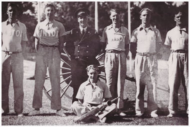
Photograph, Linton Fire Brigade Team, 1948
Inscription on the back of the photograph indicates that the photograph was taken in 1948 at a demonstration day in Ballarat. Standing, L-R: Bill Caldow, Eugene Grigg, Jim Barr (Captain), Joe Reidy, Ted Cheeseman, Arnold Chasey. Seated: V. McDonald.Framed black and white photograph of a Linton fire brigade team. Six team members are standing with arms behind their backs in front of a hand-drawn fire cart, one is seated in front of them with part of a fire pump resting on his crossed legs. Six of seven team members wear polo shirts with "LINTON" appliqued on them. The seventh wears a fire brigade uniform with double-breasted jacket and peaked hat.On back of photograph: "Linton Fire Brigade Team 1948 - Ballarat Demonstration / Standing: (L-R) W. Caldow, E. Grigg, J. Barr (Capt), J. Reidy, ? Cheeseman, A. Chasey / Sitting: V. McDonald / N887 / See Fire Brigade file".linton fire brigade, william (bill) caldow, eugene grigg, jim barr, joe reidy, ted cheeseman, arnold chasey, v. mcdonald -
 Kiewa Valley Historical Society
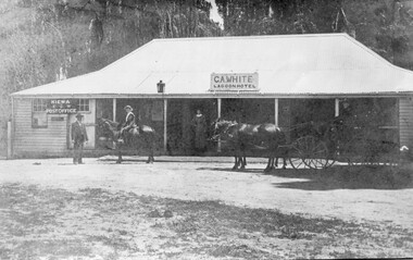
Photo - Lagoon Hotel Kiewa - C.A. White
Kiewa is a country town located on the Kiewa River. The hotel was built to supply the local people and those beyond with goods. The hotel continued operating until the 1970s.The town, Kiewa, is in the Kiewa Vally. Lawson's store was a busy place in the 1860s supplying goods to settlements up the river valleys. The Kiewa Post Office opened in 1871. Both businesses continued to operate as the town grew, the post office still providing a service to the local community.Black and white photo of C. A. White's Lagoon Hotel next to the Kiewa Post Office. This photo is published on pages 41 and 42 of 'A History of the Kiewa Valley' by Esther Temple and David LloydOn the back 'From Mrs E. Temple ' Tangambalanga 3691 / President of Kiewa Valley Historical Society' And below - 'Lagoon Hotel, Kiewa / Built by James Lawson 1860 / Post Office opened March 1871 / Building destroyed by fire Jan. 21st 1971'kiewa town, lagoon hotel, kiewa post office, james lawson -
 Colac RSL Sub Branch
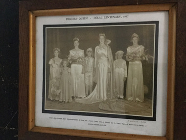
Photograph - Framed Photograph, Eric Willans, Diggers' Queen - Colac Centenary, 1937
Gold & brown wooden framed photograph or 7 women & children in formal dress - Queen, attendants, flower girl & pages.Diggers' Queen - Colac Centenary, 1937 Queen - Miss Florence Ryan; Attendants-Misses E. White and L. Ryan; Flower Girls- J Christie and P Heath; Pages-B. White and A. Cowley. AMOUNT RAISED, [pounds] 406/6/8 -
 Wycheproof & District Historical Society Inc.
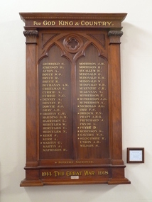
Wycheproof Honour Roll, FOR GOD KING AND COUNTRY 1914 -1918 WAR, 1919
This Honour Board listing of servicemen contributes to and is part of a National collection of Memorials to honour our armed forces. Listed are 49 names of whom 11 are Fallen.This Presbyterian Church Honour Board is believed to be the only existing 1914 - 1918 Board of its type. It has social and cultural value - and is of local,State and National importance.Large rectangular solid varnished wooden Memorial has inscribed, in gold lettering, 49 local Wycheproof and District servicemen, 11 of whom are marked Fallen. Below the top edging is some ornate wooden decoration. ARCHBOLD S . / ATKINSON H. / AXTON A. / BOYCE W.G. / BRUCE R. / BRYCE R. / BUCHANAN A.W. / CREELMAN K. / CURRIE A./ CURRIE N.G. / + DENNEY A. / DENNEY P./ DOWNIE J.J. / GRAY A.B. / + GRIFFIN C. M. / HARDING G.M. / HARRISON L . / HERCULES W. / HERCULES C. / HERCULES N. / + KERR J. / KERR A. / MARTIN G. / MARTIN J. / MATHESON H. / MORRISON J.H. / MORRISON H. / McCALLUM H. / McDONALD G. / McDONALD G. / McDONALD G.M. / McDONALDW. / McDONALD W. B. / McKENZIE C.R. / McLENNAN C.R. / McPHERSON E. / + McPHERSON A.G. / McPHERSON A. / + NICHOLLS J.L. / ORR F.J. / +ORROCK P.N. / PRATT A.H.G. / PRITCHARD J. / PRYDE L. / + PRYSE D. / + ROBINSON S. / + SAYERS W.J. + SLOCOMBE R. / UNWIN A.H. / WILSON S. Silver plaque attached reads: Presented by Mrs M.J. Matheson 1919 ARCHBOLD S . / ATKINSON H. / AXTON A. / BOYCE W.G. / BRUCE R. / BRYCE R. / BUCHANAN A.W. / CREELMAN K. / CURRIE A./ CURRIE N.G. / + DENNEY A. / DENNEY P./ DOWNIE J.J. / GRAY A.B. / + GRIFFIN C. M. / HARDING G.M. / HARRISON L . / HERCULES W. / HERCULES C. / HERCULES N. / + KERR J. / KERR A. / MARTIN G. / MARTIN J. / MATHESON H. / MORRISON J.H. / MORRISON H. / McCALLUM H. / McDONALD G. / McDONALD G. / McDONALD G.M. / McDONALDW. / McDONALD W. B. / McKENZIE C.R. / McLENNAN C.R. / McPHERSON E. / + McPHERSON A.G. / McPHERSON A. / + NICHOLLS J.L. / ORR F.J. / +ORROCK P.N. / PRATT A.H.G. / PRITCHARD J. / PRYDE L. / + PRYSE D. / + ROBINSON S. / + SAYERS W.J. + SLOCOMBE R. / UNWIN A.H. / WILSON S. Silver plaque attached reads: Presented by Mrs M.J. Matheson 1919 wycheproof presbyterian - church, first world-war, honour roll, matheson, m.j -
 Eltham District Historical Society Inc
Photograph - Aerial Photograph, Landata, Eltham / Research, Vic, Jan. 1951
Centred on Brinkkotter Road opposite Yarramie Reserve, Eltham bounded by Maroondah Aqueduct to north, Nyora Road to south, Eltham College to east and Leane Drive to west. Historic Aerial Imagery Source: Landata.vic.gov.au Aerial Photo Details: Project No :65 Project : MELBOURNE AND METROPOLITAN PROJECT NO. 2 Run : 7 Frame : 8 Date : 01/1951 Film Type : B/W Camera : EAG9 Flying Height : 12200 Scale : 12000 Film Number : 1419 GDA2020 : 37°42'32"S, 145°10'41"E MGA2020 : 339408, 5824924 (55) Melways : 22 F3 (ed. 42)Historical aerial photos and photo maps provide viusal evidence of the chronology of changes to the built landscape of the district and assist in dating other imagesaerial photo, 1951-01, eltham, neil webster collection, brinkkotter road, eltham college, leane drive, maroondah aqueduct, melways 22f3, nyora road, yarramie reserve -
 Eltham District Historical Society Inc
Photograph - Aerial Photograph, Landata, Eltham, Vic, Jan. 1951
Centred on Beard Street between Main Road and Frank Street, Eltham bounded by Maroondah Aqueduct to north, Arthur Street to south, Maroong Drive to east and Catholic Ladies College to west. Historic Aerial Imagery Source: Landata.vic.gov.au Aerial Photo Details: Project No :65 Project : MELBOURNE AND METROPOLITAN PROJECT NO. 2 Run : 7 Frame : 9 Date : 01/1951 Film Type : B/W Camera : EAG9 Flying Height : 12200 Scale : 12000 Film Number : 1419 GDA2020 : 37°42'23"S, 145°09'39"E MGA2020 : 337874, 5825170 (55) Melways : 22 B3 (ed. 42)Historical aerial photos and photo maps provide viusal evidence of the chronology of changes to the built landscape of the district and assist in dating other imagesaerial photo, 1951-01, eltham, neil webster collection, arthur street, beard street, catholic ladies college, frank street, main road, maroondah aqueduct, maroong drive, melway 22b3, research (vic.) -
 Eltham District Historical Society Inc
Photograph - Aerial Photograph, Landata, Eltham North, Feb. 1956
Centred on present day 54 Kelway Crescent, Eltham North bounded by Glen Gully Road to north, Meruka Drive to south, Eltham College to east and Leach Street to west. Historic Aerial Imagery Source: Landata.vic.gov.au Aerial Photo Details: Project No :250 Project : MELBOURNE OUTER SUBURBS PROJECT Run : 17 Frame : 113 Date : 02/1956 Film Type : B/W Camera : EAG9 Flying Height : 10000 Scale : 12000 Film Number : 1176 GDA2020 : 37°42'16"S, 145°08'08"E MGA2020 : 335650, 5825336 (55) Melways : 21 G2 (ed. 42)aerial photo, 1956-02, eltham, eltham north, glen gully road, leach street, main road, melway 21g2, meruka drive, montmorency, neil webster collection -
 Eltham District Historical Society Inc
Photograph - Aerial Photograph, Landata, Montmorency, Feb. 1956
Centred on present day Tahlee Place Reserve and Sherbourne Preschool, Montmorency bounded by Progress Road to north, Withers Way to south, Main Road to east and Leach Street to west. Historic Aerial Imagery Source: Landata.vic.gov.au Aerial Photo Details: Project No :250 Project : MELBOURNE OUTER SUBURBS PROJECT Run : 17 Frame : 114 Date : 02/1956 Film Type : B/W Camera : EAG9 Flying Height : 10000 Scale : 12000 Film Number : 1176 GDA2020 : 37°42'50"S, 145°08'02"E MGA2020 : 335512, 5824286 (55) Melways : 21 F5 (ed. 42)aerial photo, 1956-02, neil webster collection, central park, eltham, leach street, main road, melway 21f5, montmorency, progress road, withers way, sherbourne preschool, tahlee place reserve -
 Eltham District Historical Society Inc
Photograph - Aerial Photograph, Landata, Lower Plenty, Feb. 1956
Centred on present day 217 Old Eltham Road, Lower Plenty bounded by Pitt Street to north, Yarra River to south, Main Road to east and Bonds Road to west. Historic Aerial Imagery Source: Landata.vic.gov.au Aerial Photo Details: Project No :250 Project : MELBOURNE OUTER SUBURBS PROJECT Run : 17 Frame : 116 Date : 02/1956 Film Type : B/W Camera : EAG9 Flying Height : 10000 Scale : 12000 Film Number : 1176 GDA2020 : 37°43'58"S, 145°07'49"E MGA2020 : 335237, 5822186 (55) Melways : 21 E10 (ed. 42)aerial photo, 1956-02, neil webster collection, eltham, main road, bonds road, elham, lower plenty, melway 21e10, pitt street, yarra river -
 Eltham District Historical Society Inc
Photograph - Aerial Photograph, Landata, Eltham, Feb. 1956
Centred on present day Shalbury Avenue, Eltham bounded by Leane Drive and Parsons Road to north, Nyora Road to south, Reynolds Road to east and the Diamond Creek to west Historic Aerial Imagery Source: Landata.vic.gov.au Aerial Photo Details: Project No :250 Project : MELBOURNE OUTER SUBURBS PROJECT Run : 18 Frame : 95 Date : 02/1956 Film Type : B/W Camera : EAG9 Flying Height : 10000 Scale : 12000 Film Number : 1176 GDA2020 : 37°41'57"S, 145°09'51"E MGA2020 : 338145, 5825965 (55) Melways : 22 C1 (ed. 42)aerial photo, 1956-02, neil webster collection, eltham, diamond creek (creek), melway 22c1, nyora road, parsons road, reynolds road, shalbury avenue -
 Eltham District Historical Society Inc
Photograph - Aerial Photograph, Landata, Research, Vic, Feb. 1956
Centred on present day Thompson Crescent, Research bounded by Maroondah Aqueduct to north, Thompson Crescent and Nyora Road to south, Bells Hill Road to east and Eucalyptus Road to west Historic Aerial Imagery Source: Landata.vic.gov.au Aerial Photo Details: Project No :250 Project : MELBOURNE OUTER SUBURBS PROJECT Run : 19 Frame : 6 Date : 02/1956 Film Type : B/W Camera : EAG9 Flying Height : 10000 Scale : 12000 Film Number : 1176 GDA2020 : 37°42'38"S, 145°11'02"E MGA2020 : 339927, 5824736 (55) Melways : 22 H4 (ed. 42)aerial photo, 1956-02, neil webster collection, bells hill road, eltham, eucalyptus road, maroondah aqueduct, melway 22h4, nyora road, research (vic.), thompson crescent -
 Eltham District Historical Society Inc
Photograph - Aerial Photograph, Landata, Research, Vic, Apr. 1963
Centred on present day Thompson Crescent and Nicholson Close, Research bounded by Maroondah Aqueduct to north, Nyora Road to south, Eltham College to east and Eltham Gateway Hotel to west. Historic Aerial Imagery Source: Landata.vic.gov.au Aerial Photo Details: Project No :486 Project : MELBOURNE (1963) PROJECT Run : 5 Frame : 61 Date : 04/1963 Film Type : B/W Camera : RC8 Flying Height : 5100 Scale : 9600 Film Number : 1805 GDA2020 : 37°42'24"S, 145°10'06"E MGA2020 : 338528, 5825143 (55) Melways : 22 D3 (ed. 42)aerial photo, neil webster collection, eltham, 1963-04, eltham college, eltham gateway hotel and conference centre, maroondah aqueduct, melway 22d3, nicholson close, nyora road, research (vic.), thompson crescent -
 Eltham District Historical Society Inc
Photograph - Aerial Photograph, Landata, Eltham, Vic, Apr. 1963
Centred on present day John Street, Eltham between Main and Bible streets bounded by Elsa Court to north, Main Road Bridge to south, Wattle Grove to east and Bolton Street to west. Historic Aerial Imagery Source: Landata.vic.gov.au Aerial Photo Details: Project No :486 Project : MELBOURNE (1963) PROJECT Run : 6 Frame : 123 Date : 04/1963 Film Type : B/W Camera : RC8 Flying Height : 5100 Scale : 9600 Film Number : 1805 GDA2020 : 37°43'12"S, 145°08'54"E MGA2020 : 336800, 5823623 (55) Melways : 21 J6 (ed. 42)aerial photo, neil webster collection, 1963-04, bolton steet, elsa court, eltham, john street, main road, main road bridge, melway 21j6, wattle grove -
 Eltham District Historical Society Inc
Photograph - Aerial Photograph, Landata, Eltham, Vic, Apr. 1963
Centred on present day Eltham Ridge, Bolton Street, Eltham bounded by Elsa Court to north, Main Road to south, Bible Street to east and Reichelt Avenue and Rattray Road to west. Historic Aerial Imagery Source: Landata.vic.gov.au Aerial Photo Details: Project No :486 Project : MELBOURNE (1963) PROJECT Run : 6 Frame : 124 Date : 04/1963 Film Type : B/W Camera : RC8 Flying Height : 5100 Scale : 9600 Film Number : 1805 GDA2020 : 37°43'12"S, 145°08'16"E MGA2020 : 335876, 5823604 (55) Melways : 21 G6 (ed. 42)aerial photo, neil webster collection, 1963-04, bible street, bolton street, eltham, eltham ridge, main road, montmorency, rattray road, reichelt avenue -
 Eltham District Historical Society Inc
Photograph - Aerial Photograph, Landata, Eltham, Vic, Apr. 1963
Centred on present day Griffith Park Road, Eltham bounded by Mount Pleasant Road to north, Yarra River and Templestowe to south, Main Road at Reynolds Road to east and Falkiner Street to west. Historic Aerial Imagery Source: Landata.vic.gov.au Aerial Photo Details: Project No :486 Project : MELBOURNE (1963) PROJECT Run : 7 Frame : 233 Date : 04/1963 Film Type : B/W Camera : RC8 Flying Height : 5100 Scale : 9600 Film Number : 1805 GDA2020 : 37°44'04"S, 145°09'10"E MGA2020 : 337237, 5822053 (55) Melways : 22 A10 (ed. 42)aerial photo, neil webster collection, 1963-04, eltham, falkiner street, griffith park road, melway 22a10, mount pleasant road, reynolds road, templestowe, yarra river -
 Eltham District Historical Society Inc
Photograph - Aerial Photograph, Landata, Eltham, Vic, Apr. 1972
Centred on present day Zig Zag Road near Coolabah Drive, Eltham bounded by Allendale Road to north, Park West Road to south, Parsons Road to east and Banks Road to west. Historic Aerial Imagery Source: Landata.vic.gov.au Aerial Photo Details: Project No :985 Project : MELBOURNE 1972 Run : 26 Frame : 191 Date : 04/1972 Film Type : B/W Camera : RC10 Flying Height : 5700 Scale : 9600 Film Number : 2636 GDA2020 : 37°41'56"S, 145°09'26"E MGA2020 : 337533, 5826000 (55) Melways : 22 A1 (ed. 42)aerial photo, neil webster collection, 1972-04, allendale road, eltham, eltham north, zig zag road, banks road, coolabah drive, melway 22a1, park west road, parsons road -
 Eltham District Historical Society Inc
Photograph - Aerial Photograph, Landata, Eltham, Vic, Apr. 1972
Centred on present day Parsons Road, Eltham bounded by Allendale Road to north, Frank Street to south, Research Shops and Raglan Road to east and Zig Zag Road to west. Historic Aerial Imagery Source: Landata.vic.gov.au Aerial Photo Details: Project No :985 Project : MELBOURNE 1972 Run : 26 Frame : 192 Date : 04/1972 Film Type : B/W Camera : RC10 Flying Height : 5700 Scale : 9600 Film Number : 2636 GDA2020 : 37°42'00"S, 145°09'59"E MGA2020 : 338360, 5825897 (55) Melways : 22 D1 (ed. 42)aerial photo, neil webster collection, 1972-04, allendale road, eltham, zig zag road, frank street, melway 22d1, parsons road, raglan road, research (vic.), research shops, eltham barrel -
 Eltham District Historical Society Inc
Photograph - Aerial Photograph, Landata, Eltham, Vic, Apr. 1972
Centred on present day Woodridge Estate, Eltham bounded by Park Road to north, Mount Pleasant Road to south, Stokes Orchard Estate to east and Eltham Railway Station to west. Historic Aerial Imagery Source: Landata.vic.gov.au Aerial Photo Details: Project No :985 Project : MELBOURNE 1972 Run : 27 Frame : 46 Date : 04/1972 Film Type : B/W Camera : RC10 Flying Height : 5700 Scale : 9600 Film Number : 2636 GDA2020 : 37°42'49"S, 145°09'46"E MGA2020 : 338053, 5824365 (55) Melways : 22 C5 (ed. 42)aerial photo, neil webster collection, 1972-04, eltham, eltham railway station, melway 22c5, mount pleasant road, park road, stokes orchard estate, woodridge estate -
 Eltham District Historical Society Inc
Photograph - Aerial Photograph, Landata, Eltham, Vic, Apr. 1972
Centred on present day Main Road at Pryor Street, Eltham bounded by Park West Road to north, Napoleon Street to south, Woodridge Estate to east and Ryans Road to west. Historic Aerial Imagery Source: Landata.vic.gov.au Aerial Photo Details: Project No :985 Project : MELBOURNE 1972 Run : 27 Frame : 47 Date : 04/1972 Film Type : B/W Camera : RC10 Flying Height : 5700 Scale : 9600 Film Number : 2636 GDA2020 : 37°42'45"S, 145°09'12"E MGA2020 : 337223, 5824470 (55) Melways : 22 A4 (ed. 42)aerial photo, neil webster collection, 1972-04, eltham, eltham railway station, woodridge estate, eltham shops, main road, melway 22a4, napoleon street, park west road, pryor street, ryans road -
 Eltham District Historical Society Inc
Photograph - Aerial Photograph, Landata, Eltham, Vic, Apr. 1972
Centred on present day Dalton Street at Mount Pleasant Road, Eltham bounded by Arthur Street to north, Yarra River and Kent Hughes Road to south, Eucalyptus Road to east and Susan Street to west. Historic Aerial Imagery Source: Landata.vic.gov.au Aerial Photo Details: Project No :985 Project : MELBOURNE 1972 Run : 28 Frame : 208 Date : 04/1972 Film Type : B/W Camera : RC10 Flying Height : 5700 Scale : 9600 Film Number : 2635 GDA2020 : 37°43'29"S, 145°08'54"E MGA2020 : 336816, 5823118 (55) Melways : 21 J8 (ed. 42)aerial photo, neil webster collection, 1972-04, eltham, arthur street, dalton street, eucalyptus road, kent hughes road, melway 21j8, mount pleasant road, susan street, yarra river -
 Mission to Seafarers Victoria
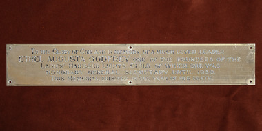
Plaque - Memorial Plaque, Ethel Augusta Godfrey
This plaque was erected in the Williamstown Sailors' Rest, the former skating ring in Thompson Street. It's one the three memorials to Ethel Godfrey with the stained glass window in the St Peter chapel in the Central Institute (See 0064.2) ) and the optus sectile plaque in the 1888 Port Melbourne Institute (See 2053) . This plaque was moved to the Nelson Place building when the Mission purchased the E,S&A Bank in 1943. In 1982, the plaque ws removed from the Williamstown mission along with 4 other plaques, objects and furniture to furnish the chapel of the new Flagstaff Maritime Museum. The transfer of the 5 plaques was requested in 2020 and they returned to the Mission's collection in 2022.The plaque along with the two other memoriels erected in the memory of Ethel Godfrey demonstrates the gratitude for the her 30 years of work.Rectangular plaque for Ethel Augusta Godfrey ethel augusta godfrey 1861-1935, williamstown, thompson street, seamen's mission, sailors' rest, flasgstaff maritime museum, lhlg -
 Warrnambool and District Historical Society Inc.
Plate name, Tribute Egbert John Connell, C 1930
Doctor Egbert Connell worked as an Honorary Medical Officer at the Warrnambool General Hospital and benevolent Asylum from around 1901 and continued until his death on 4th April 1928 from pneumonia. he had a private practice at his house " Ambleside" in Koroit Street Warrnambool opposite the Baptist church. He was highly regarded as being kind and sympathetic towards his patients. His practice was subsequently bought by Dr A E Brauer another of Warrnambool's well known doctors. This glass plate accompanied a stain glass window which was once in the Warrnambool hospital. It was moved to the chapel at Flagstaff Hill. A link to one of Warrnambool's long serving doctors who was involved in the community and as such has social and historical importance.Green glass plate with black text and mounted on particle board and secured with metal clips.A tribute to Egbert John Connell MBBS who for 30 years rendered devoted and valuable service to this institution Obiit April 4th 1928 A Dwarrnambool, egbert connell, doctor egbert connell -
 Federation University Historical Collection
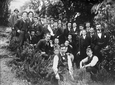
Photograph - Black and White Photograph, Students in the Ballarat School of Mines Botanical Garden, c1897, 1897-1898
A number of names written on the back of the photograph match with names in the Ballarat School of Mines Annual Report 1897 and 1898. These are: Robert Allan; (Thomas E. or William T. ) Atherton; Percy Bailey, James A. Bass; Fred F. Bradford; William Brokenshire; Joseph Bryant; Cecil Eeles; Thomas Evans; William C. Gosman; John Hill; Edward P. Johnson; Duncan W. Kennedy; James Kidd; John W. Martin; Percy Osborne; J.A. Porter; Thomas Phillipson; Frank A. Steward; Robert G. Todd; Thomas A. Uthwatt A number of names are not matched: - Bollin, Curry, Morey, Mann. ThompsonBlack and white photograph mounted on grey card showing a number of students and instructors of the Ballarat School of mines. They are thought to be in the Ballarat School of Mines Materia Medica Garden (System Garden) for either a botany, chemistry or materia medica lesson, or as part of the Ballarat Field Naturalists group. The person at the front wearing an apron is George Porter Day.A number of names are written in ink on the back of the photo " Tom Evans, Osborne, Atherton, Phillipson, Eccles, Allan, Todd, Morey, Bradford, Curry, John Marian, Char Bailey, Uthwatt, John M. Sutherland, Kennedy, Mat Thompson, Hill, Steward, Martin, Kidd, Brokenshire, Gosman, Bollin, William D. Hill, "ballarat school of mines, science, material media, botanical gardens, system garden, ballarat school of mines botanical gardens, bollin, curry, morey, mann, thompson, james a. bass, fred f. bradford, william brokenshire, joseph bryant, cecil eeles, thomas evans, william gosman, john hill, edward johnson, duncan kennedy, james kidd, john martin, percy osborne, j.a. porter, thomas phillipson, frank steward, robert todd, thomas uthwatt, photography, foto, class, george day, george porter day, atherton, percy bailey, parks and gardens -
Federation University Historical Collection
Correspondence, Correspondence from the Royal Institute of Architects regarding the Architectural Technicians' Course, 1949, 23/09/1949
11994.1 Page 01. Letter, dated 26/09/1949, from the Secretary of The Royal Victorian Institute Of Architects to F. E. Ferguson Esq., Registrar, The School of Mines and Industry. Letter requests a new architectural syllabus that caters to the separation of architectural professions into Qualified Architect and Architectural Technician 11994.2 Page 02. Recommending the Ballarat School of Mines establish an Architectural Technician course 11994.3 Page 03. Recommended Architectural Technicians course; 1st, 2nd & 3rd year subjects 11994.4 Letter from F.E. Ferguson to The Royal Victorian Institute of Architects confirming the establishment of the Architectural Technician course11994.1 Typed letter on quarto paper with letterhead 11994.2 Typed letter on quarto paper 11994.3 Typed letter on airplane paper, with an airoplane watermark 11994.4 Typed letter on quarto paperf.e. ferguson, royal victorian institute of architects, ballarat school of mines, registrar, architectural technician, 1949 -
 Rutherglen Historical Society
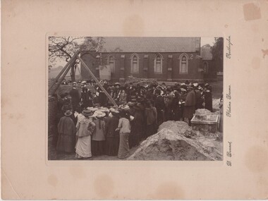
Photograph, D. Bennett, 1905 (Exact)
On note in photograph file: Laying the Foundation Stone of St Stephen's Rectory, High St, Rutherglen. "The foundation stone was laid on Wednesday, 21st June, 1905, before a large number of parishioners and visitors by Mrs T H Armstrong, wife of the Bishop of Wangaratta; Royston Ready presenting Mrs Armstrong with a silver trowel as a momento of the occasion." From - The Parish of St Stephen, Rutherglen 1863-1963. The Rector at this time was Rev A J E Harris-Rivett. St Stephens Rectory, High Street, Rutherglen. Mrs Armstrong, wife of the first Bishop laid the stone. Information from Father Angus Cooper - 1987Photograph of the laying of the foundation stone at St Stephens Rectory, Rutherglen, black & white, cardboard, unframed"D. Bennett, Platino Bromo, Rutherglen" On back of photo: "Laying of foundation stone of rectory of St Stephens Rutherglen"anglican church, st stephens church, royston ready, t h armstrong -
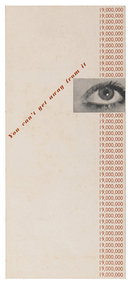 RMIT Design Archives
Booklet - Brochures, You can't get away from it
Richard Beck established a consultancy as an industrial designer in London in the 1930s, designing posters, booklets and advertisements for London Transport, Shell-Mex, Orient Line and the London GPO. His work was illustrated in Radio Times, Evening Standard and News Chronicle. His posters used montage and surrealist techniques, as in this example, reminiscent of E McKnight Kauffer who was prominent in commercial art in interwar England. The London Journal Art and Industry reproduced a number of Beck's posters for the Orient Line and London Transport and in 1938 Modern Publicity's annual round-up featured Beck's cover design and included a profile of his work.Brochure for London Transportgraphic design, mid-century modern, design -
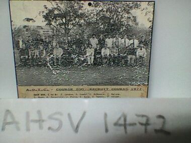 Ambulance Victoria Museum
Photograph, Ambulance Officers Training Centre Course 200, Recruit Course, 1977, 1977
Front Row L to R: J. Brereton, d. Catteral, M. Chilton, L. Cooke, P. Crew, K Crowle, J. Engledow, K. Filcock, K. Ford, R. Green, K. Holt, M. Hunting, C. Linke, S. Lamb, J. Lee. Back Row L to R: J. Lennon, D. Lumby. J. McDonald, P. Malone, T. Nunn, R. Paravinic, J. Poole, R. Reid, W. Sampey, P. Sanger, E. Schanssema, K Struthers, P. Turner, N. White, R. Williams, P. Williams. P. Worboys.Black and White photograph of ambulance officer recruitsambulance officers training centre, recruits