Showing 22198 items
matching parks
-
 Kew Historical Society Inc
Archive (Sub-series) - Subject File, Findon (Kew), 1958
Various partiesReference, Research, InformationSecondary Values (KHS Imposed Order)Subject file on Findon, an early mansion in Studley Park and its owners including the Hon Henry “Money” Miller. The two main items in the file are an extract from Victoria and Its Metropolis on Miller and an article on the organ that was once in the house and according to an article on the Organ Trust website, currently in the Wesley Uniting (formerly Methodist Church) in Box Hill. kew (vic) - history, findon, henry "money" miller, organs - victoriakew (vic) - history, findon, henry "money" miller, organs - victoria -
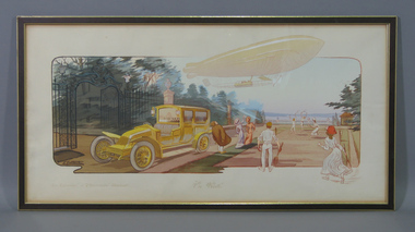 Tennis Australia
Poster, 1915
Reproduction of colour advertising poster for Renault company with title caption: 'EN VISITE'. Depicts a zeppelin about to land close to a tennis court on a terrace. A large motor car is parked nearby. Other text captions: 'LE "LEVRIER" ET "L'HIRONDELLE" RENAULT'. Materials: Ink, Paper, Cardboard, Wood, Glass, Metal, Adhesive labeltennis -
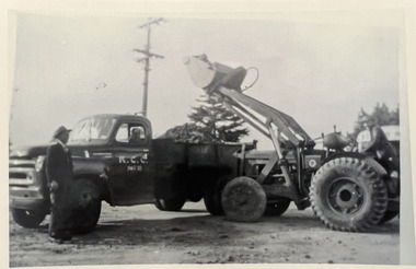 Kew Historical Society Inc
Photograph - Road works in Studley Park Road, c. 1960
Tom Bentley (1912-1993) was born in Lancashire (UK). From circa 1951, he was the Overseer/Superintendent of Outdoor Works for Kew City Council. Until his retirement in the 1970s, he was based at the Kew Council Depot, located in the former MTB Horse Tram Depot on the corner of Disraeli and High Streets, Kew. Accompanying the set of twelve photographs is a 12-page illustrated biography of the Bentley and Plumridge families, separately kept in the 'Bentley' subject file.Duplicate black and white positive print photograph of road works in Studley Park Road, Kew, carried out under the supervision of Tom Bentley, Overseer/Superintendent of Outdoor Works for the City of Kew. The location at which the photograph was taken is believed, by the donor, to be in the vicinity of Tara Hall (dem. 1960). The photograph shows two Council vehicles.city of kew, public works, studley park road, tom bentley, road works -
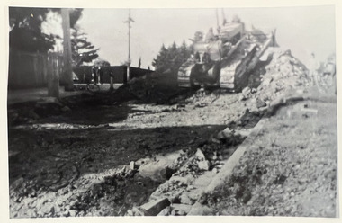 Kew Historical Society Inc
Photograph - Road works in Studley Park Road, c. 1960
Tom Bentley (1912-1993) was born in Lancashire (UK). From circa 1951, he was the Overseer/Superintendent of Outdoor Works for Kew City Council. Until his retirement in the 1970s, he was based at the Kew Council Depot, located in the former MTB Horse Tram Depot on the corner of Disraeli and High Streets, Kew. Accompanying the set of twelve photographs is a 12-page illustrated biography of the Bentley and Plumridge families, separately kept in the 'Bentley' subject file.Duplicate black and white positive print photograph of road works in Studley Park Road, Kew, carried out under the supervision of Tom Bentley, Overseer/Superintendent of Outdoor Works for the City of Kew. The location at which the photograph was taken is believed, by the donor, to be in the vicinity of Tara Hall (dem. 1960). The photograph shows a Council vehicles shifting soil.city of kew, public works, studley park road, tom bentley, road works -
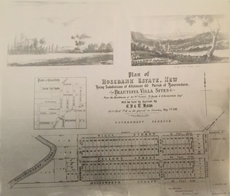 Kew Historical Society Inc
Print - Subdivision Plan, Rosebank Estate, Kew, Nineteenth Century
This work forms part of the collection assembled by the historian Dorothy Rogers, that was donated to the Kew Historical Society by her son John Rogers in 2015. The manuscripts, photographs, maps, and documents were sourced by her from both family and local collections or produced as references for her print publications. Many were directly used by Rogers in writing ‘Lovely Old Homes of Kew’ (1961) and 'A History of Kew' (1973), or the numerous articles on local history that she produced for suburban newspapers. Most of the photographs in the collection include detailed annotations in her hand. The Rogers Collection provides a comprehensive insight into the working habits of a historian in the 1960s and 1970s. Together it forms the largest privately-donated collection within the archives of the Kew Historical Society.A photographic reproduction of a plan in the Vale Collection of the State Library of Victoria. The plan shows the Rosebank Estate in Kew which was offered for sale in 1881. The subdivision was located in Studley Park and included lots in Redmond Street; Fellows Street; Wills Street; Molesworth Street; Barry Street and Princess Street. The surveyor of the subdivision was the local architect George Wharton.rosebank estate (kew), subdivisions -- studley park -- kew (vic.), thomas wills, wills family -
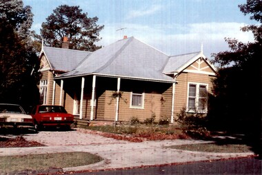 Surrey Hills Historical Society Collection
Photograph, 17 Essex Road, Surrey Hills
An Edwardian style timber house with a galvanised iron roof on a wide block. It is painted in a mid-brown with white trim to the windows, gables, finials and veranda posts. The veranda is timber with 6 turned posts. The front door is accessed from the side off the driveway in which are parked 2 (?) Ford falcons, one cream-coloured and the other red. -
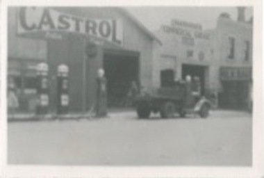 Kilmore Historical Society
Photograph, Hardidge's Commercial Garage, Early 20th Century
10.5cm x 7cm black and white photograph of Hardidge's Commercial Garage on Sydney Street. The Garage is in a light coloured building sandwiched between a Castrol petrol station and a milk bar. A vehicle is parked out the front with a man sitting in the tray and one standing partially obstructed and petrol bowsers can be seen. An enlarged photo is available. Written on back: 690garage, mechanics, vehicle repair -
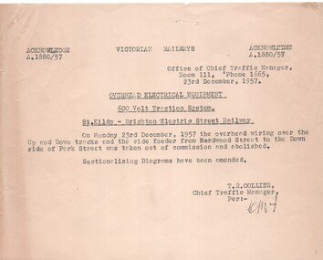 Melbourne Tram Museum
Document - Notice, Victorian Railways, "Overhead Electrical Equipment - 600V Traction System - St Kilda - Brighton Electric Street Railway", 23/12/1958 12:00:00 AM
Half foolscap Sheet Gestener printed notice titled "Overhead Electrical Equipment - 600V Traction System - St Kilda - Brighton Electric Street Railway" advising that the overhead and feeder between Hardwood St and Park St was taken out of service and abolished. Signed by T. R. Collier, Chief Traffic Manager, 23 Dec. 1957.trams, tramways, aeta, vr, overhead, closure, st kilda -
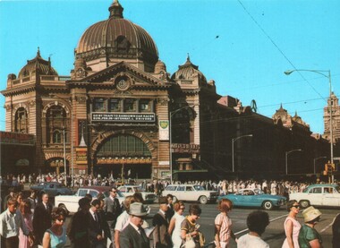 Melbourne Tram Museum
Postcard, Murfett Publishers, "Flinders Street Station", early 1960's
Postcard - Colour - National View by Murfett Publishers, BP1055 of the front of Flinders St Station, early 1960's. Many people crossing the intersection - no trams. Has a sign on the station, advertising car races at Sandown Park. On the rear - has a divided back, with National View by Murfett Publishers and logo, description of the station and number BP1055On the rear has the stamp of Graeme S Breydon - see image i2.trams, tramways, swanston st, flinders st station, flinders st -
 Melbourne Tram Museum
Photograph - Block Mounted Photograph, Surrey Hill Neighbourhood Centre, c1920
Photograph - mounted onto a heavy card, numbered 65-574 in the top right hand corner of MTTB No. 138 at the intersection of Riversdale and Warragul Road intersection Wattle Park. Has in the background the Tea Rooms and notes that they were on the South West corner of the intersection. Notes that the image is courtesy of the TMSV. See image i2 for a scan of the photograph.On rear in ink "Copied for Keith Kings 2002: and the "Surrey Hill Neighbourhood Centre" stamp.trams, tramways, wattle park, riversdale road, tram 138 -
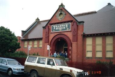 Melbourne Tram Museum
Photograph - Set of 4 Colour Print/s, Public Transport Corporation (PTC), 1991
Set of 4 colour prints of the tramway hall in Stanhope St Malvern used a the "Tramway Museum" .1 - Hall building with a sign "Tramway Museum" above the doorway. .2 - ditto with a sign in the bottom edge, say "official opening" .3 - Interior view with people looking at the displays .4 - Exterior view of the car park side of the buildingtrams, tramways, malvern depot, property, museum, stanhope st -
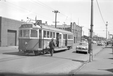 Melbourne Tram Museum
Negative, Travis Jeffrey, 1/12/1959 12:00:00 AM
Negative of tram 822 in Swan St Richmond, at Bendigo St. Tram has destination Wattle Park - Elgar Rd and Route No 70. Photo shows driver on road talking to conductor who is leaning out of doorway. Tram stop has a bundy clock. On the side of the bundy clock could be a point bar clipped to the clock case.Paper folder that contained the negative had "NR14A" written in red ink, "M14" written in pencil, "14A" written in blue ink, "P Ormond" written in purple ink and date stamped as 1 Dec 1959.trams, tramways, w5 class, swan st, crews, bundy clock, tram 822 -
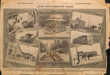 Melbourne Tram Museum
Newspaper, Australian Tramway & Motor Omnibus Employees Association (ATMOEA), "Our photograph Page", 31/10/1929 12:00:00 AM
Newspaper clipping from The Tramway Record, 31/10/1929, titled "Our photograph Page" featuring photographs from various Australian tramway systems - Sydney, Wattle Park cable car, St Kilda, Kimberley Pier, Wellington cable tram and Collins St during the cable conversion with a bus alongside. Published by the AMOTEAtrams, tramways, cable trams, sydney, collins st, conversion, st kilda, wattle park, buses, kimberley -
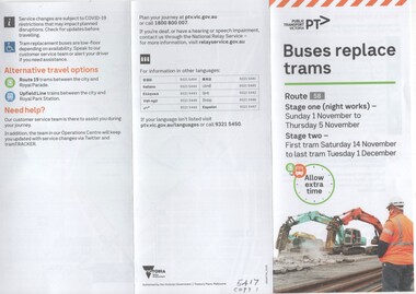 Melbourne Tram Museum
Pamphlet, Public Transport Victoria (PTV), "Buses replace trams - Route 58", Nov. 2020
Pamphlet - 3 fold DL, titled "Buses replace trams - Route 58", published by PTV about the replacement of trams on route 58, during the reconstruction of Royal Park trackwork between 14/11 and 1/12/2020. Has a map of the replacement services. Has PTV and Victorian Government logos. two copies held.trams, tramways, route 58, trackwork, bus replacement, royal park -
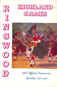 Ringwood and District Historical Society
Programme, Ringwood Highland Games- Official Programme, 1972
28 page bookletInside cover, Page 1- Details of Games: Ringwood Highland Games 1972. Jubilee Park, Ringwood. Sunday, 20th February, 1972. Sponsored by the Ringwood City Council. Organised by the Lions Club of Ringwood. Chief of the Gathering- The Hon. J. W. Manson, M.L.A.. -
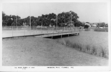 Stawell Historical Society Inc
Photograph, Cato Lake with the Swimming Pool c 1950's
Two black and white post cards of the Olympic swimming pool in Cato lake c 1950's. The Rose Series P 14901 shows the swimming pool and lake with the swimming pool dominating the photograph. Four flag posts are clearly visible and the pool connected to the edge of the lake. The Rose Series P 14012 also shows the Olympic pool but more of the lake and boundary. with seating around the lake. In March 1957 Cato Lake was emptied for construction of the Olympic pool and officially opened on 15.11.1958. Twenty seven years later In January 1985 the pool was found to be leaking and Borough Council in February banned further use of the Olympic pool. Eventually the Olympic pool was demolished in April 1988.Two black & white Rose series post cards of Cato Olympic swimming pool Stawell Vic. c 1950's. Series P 14901 is nearly a complete view of the Olympic pool with four flag posts in view and trees and buildings in the distance. Series P 14012 has only a small section of the Olympic pool in the photograph with just 3 flag poles in view. There are 2 concrete and timber seats in the foreground and Cato lake is very still, reflecting the distance trees.The Rose Series P 14901 Swimming Pool Stawell Vic. and The Rose Series P 14912 Cato Park and swimming pool Stawell, Vic. Both post cards were Published by Rose Stereograph Co., Armadale, Victoria. The "Rose" series De Luxe.stawell -
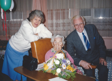 Melbourne Legacy
Photograph, Widow 100th Birthday, 1994
Photograph of 100th birthday celebrations for Mrs Nelson in February 1994. She was being visited by Legatee Bill Smith and his wife Betty.A record of a widow reaching 100 years of age and Legacy marking the occasion with a visit and flowers.Colour photo of the 100th birthday of Mrs Voilet Nelson with L/- Bill Smith and Mrs Smith.Handwritten on reverse 'Mrs Violet Nelson with Legatee Bill Smith and his wife Betty, at her 100th birthday. Mrs Nelson was 100 on 11 Feb 1994. She now lives at the "Belvedere" nursing home, Princes hwy, Noble Park' in blue pen.widows, birthday -
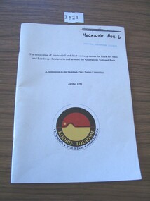 Stawell Historical Society Inc
Book, Koorie Tourism Unit, A Submission to Victorian Place Names Committee 24 May 1990, 1990
White card with black print and yellow, black and red circle with yellow and white printThe restoration of Jardwadjali and Djab warruning names for Rock Arts Sites and Landscape Features in and around Grampians National Park Underlined: A Submission to the Victorian Palce Names Committee 24 May 1990 Yellow Print: Koorie Tourism Black Print: Victorian Tourism Commissionstawell -
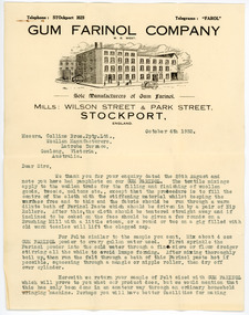 National Wool Museum
Letter - Gum Farinol Company Correspondence, Gum Farinol Company, 4 October 1933
Letter written to Collins Bros Mills in Geelong from Gum Farinol Company in England. The letter details the instructions, use and benefits of gum farinol in woollen textiles. Letter consisting of two pages of cream paper with printed and typed black text. The second page has hand written text in pencil written on back. Both page show a letter head graphic image of a building with people and vehicles out the front. GUM FARINOL COMPANY / W. G. WEST. / Sole Manufacturers of Gum Farinol. / MILLS: WILSON STREET & PARK STREET / STOCKPORT, / ENGLAND. / Messrs. Collins Bros. Pty. Ltd. / Woollen Manufacturers, / Latrobe Terrace, / Geelong, Victoria, / Australia. / October 4th 1933letter, correspondence, company records, gum farinol company, textile industry, wool industry, wool mills, collins bros mill pty ltd, technology -
 Eltham District Historical Society Inc
Photograph, Shire of Nillumbik World War One Memorials tour, 10 August 2016, 10 August 2016
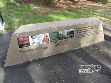
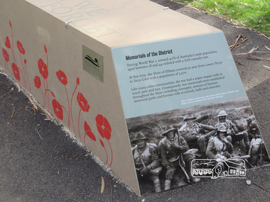
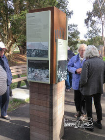
As part of a program to acknowledge the Anzac Centenary Nillumbik Shire Council partnered with Yarra Plenty Regional Library to provide a bus tour with commentary of local sites of significance. These included Eltham township, the Shire of Eltham War Memorial at Kangaroo Ground, Christmas Hills, Hurstbridge memorial recreation park and finished at Eltham Library to view the Writing the War exhibtion at Eltham Library Community Gallery. In June 2014 Nillumbik Shire Council received Anzac centenary Local Grants Program funding to create new interpretative signage that acknowledged the history of the Hurstbridge Memorial Recreation Park as a memorial to all who served in the First World War. Born Digitalworld war 1, war memorials, shire of nillumbik, interpretative signage, hurstbridge -
 Eltham District Historical Society Inc
Photograph, Shire of Nillumbik World War One Memorials tour, 10 August 2016, 10 August 2016
As part of a program to acknowledge the Anzac Centenary Nillumbik Shire Council partnered with Yarra Plenty Regional Library to provide a bus tour with commentary of local sites of significance. These included Eltham township, the Shire of Eltham War Memorial at Kangaroo Ground, Christmas Hills, Hurstbridge memorial recreation park and finished at Eltham Library to view the Writing the War exhibtion at Eltham Library Community Gallery. In June 2014 Nillumbik Shire Council received Anzac centenary Local Grants Program funding to create new interpretative signage that acknowledged the history of the Hurstbridge Memorial Recreation Park as a memorial to all who served in the First World War. Born Digitalworld war 1, war memorials, shire of nillumbik, hurstbridge, interpretative signage -
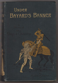 Cheese World Museum
Book, Under Bayard's Banner, 1894
The Percy Uebergang family lived at Tooram Park, Allansford from 1912 until 1992. Percy and Myrtle Uebergang's children were twins, Ray and Joyce born in 1926 who lived at Tooram Park until their deaths, Ray in 1986 and Joyce in 1992. Neither Ray nor Joyce married and following the death of her brother Joyce set up the Ray and Joyce Uebergang Foundation which supports the local community. This bookis part of the collection of items given into the care of the Cheese World Museum. Uebergang catalogue No.K51 This book was school prize donated to Percy Uebergang in 1899 whilst a pupil at Cudgee State School.Green cloth hardbound book with gold print title 'Under Bayards Banner: a Story of the Days of Chivalry' and a in black print picture of two knights. On the spine the title is in gold print, the author's name Henry Frith, in black and a picture of a couple. On the back cover there is a black spray of leaves. The book includes eight illustrations by E Blair Leighton. There is an ornate book plate on the fly leaf which has a border of pink flowers on three sides.Presented to Percy Uebergang/ Class IV/ SS No.105 Cudgee/ 23-6-99allansford, uebergang, frith, henry, cassell & co ltd, children's books -
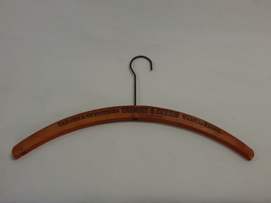 Cheese World Museum
Coathanger, prior to 1973
The Percy Uebergang family lived at Tooram Park, Allansford from 1912 until 1992. Percy and Myrtle Uebergang's children were twins, Ray and Joyce born in 1926 who lived at Tooram Park until their deaths, Ray in 1986 and Joyce in 1992. Neither Ray nor Joyce married and following the death of her brother Joyce set up the Ray and Joyce Uebergang Foundation which supports the local community. This coathanger is part of the collection of items given into the care of the Cheese World Museum. Cramond and Dickson was a large department store located on the corner of Liebig and Timor Streets Warrnambool trading from 1856 to 1973.Orange varnished curved wooden coat hanger with wire hook damaged on one endBlack ink engraving -Tailors & Outfitters Cramond & Dickson Warrnambool/ Made in Germanywarrnambool, cramond & dickson, uebergang, germany, coathanger -
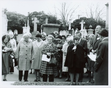 Kew Historical Society Inc
Photograph - Tour of the Boroondara (Kew) General Cemetery, 1977
Boroondara Cemetery, established in 1858, is within an unusual triangular reserve bounded by High Street, Park Hill Road and Victoria Park, Kew. By the 1890s, the Boroondara Cemetery was a popular destination for visitors and locals admiring the beauty of the grounds and the splendid monuments. The Boroondara Cemetery is of historical significance for the graves, monuments and epitaphs of a number of individuals whose activities have played a major part in Australia's history. They include the Henty family, artists Louis Buvelot and Charles Nuttall, businessmen John Halfey and publisher David Syme, artist and diarist Georgiana McCrae, actress Nellie Stewart and architect and designer of the Boroondara and Melbourne General Cemeteries, Albert Purchas.Walking tour led by Kew Historical Society members for members of the Royal Historical Society of Victoria in 1977. The photograph shows members of both parties assembled at a grave in the Cemetery. The photograph was one of six taken by KHS member Stewart West on that occasion, and subsequently donated by him to the collection by him.Reverse: "Front row in dark coat and glasses - Mrs Mills, With dark glasses reading - Mrs Ekberg (KHS member); Second from right Mr Slattery then president of Society; Far left Miss B Mackie (KHS member)" boroondara general cemetery, kew cemetery, walking tours -
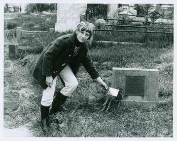 Kew Historical Society Inc
Photograph - Tour of the Boroondara (Kew) General Cemetery, 1977
Boroondara Cemetery, established in 1858, is within an unusual triangular reserve bounded by High Street, Park Hill Road and Victoria Park, Kew. By the 1890s, the Boroondara Cemetery was a popular destination for visitors and locals admiring the beauty of the grounds and the splendid monuments. The Boroondara Cemetery is of historical significance for the graves, monuments and epitaphs of a number of individuals whose activities have played a major part in Australia's history. They include the Henty family, artists Louis Buvelot and Charles Nuttall, businessmen John Halfey and publisher David Syme, artist and diarist Georgiana McCrae, actress Nellie Stewart and architect and designer of the Boroondara and Melbourne General Cemeteries, Albert Purchas.Walking tour led by Kew Historical Society members for members of the Royal Historical Society of Victoria in 1977. The photograph shows a Kew youth placing a sprig of Rosemary on Ellen Quick's grave. The photograph was one of six taken by KHS member Stewart West on that occasion, and subsequently donated by him to the collection by him.Reverse: "Kew youth placing a sprig of rosemary on grave of Ellen Quick nee Derrick who was the first burial on 12/3/1859. Her family Derricks were early Kew Landowners." boroondara general cemetery, kew cemetery, walking tours, ellen quick, dannock family, kew pioneers -
 Kew Historical Society Inc
Photograph - Filling in the Outer Circle Railway cutting at East Kew, 1939
W.D. Vaughan (Kew's Civic Century, 1960, pp.195-6) quotes Council Minutes of 1938 and 1939 to record that: "After protracted negotiations between the Council, the Railways Department and the Tramways Board agreement was reached in June, 1938, for the filling of the railway cutting at the Harp Junction and shifting tram tracks to the High Street alignment ... The Outer Circle railway land from Princess Street to Park Crescent was purchased by the Kew Council in October, 1939, for 2,750 [pounds]. The land from Park Crescent to High Street was leased for 1 [pound] per annum. Considerable work was done in levelling the embankments to the original surface level."Important and rare photograph of the period, showing major works by Kew Council in Kew East working on a significant piece of urban infrastructure.Small, original black and white positive (photograph) showing workers and vehicles filling in the tracks of the former Outer Circle railway at East Kew. In the background is the metal bridge with brick piers, adjacent to the Harp Junction. The bridge crossed the cutting, linking the two parts of High Street. Behind the tip truck, painted on the side with the name 'Fowler Quarries' [located Keilor Road, North Essendon], one can see shops [including T.G. Garroway, Cash Grocer] in High Street. What appears to be the City of Kew Steamroller is immediately in front of the bridge. A group of passers-by watch from the bridge and from the road. Annotation in pencil on verso: "Filling in Outer Circle line at High St East Kew prior to straightening High St. (c. Feb 1930?)outer circle railway, railway cuttings, harp junction, high street -- kew east -
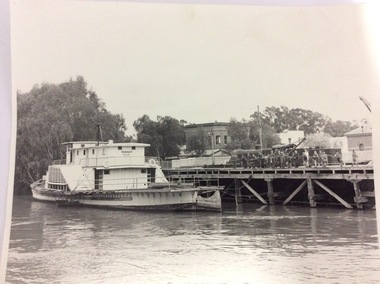 Port of Echuca
Black and white photograph, 1980? A note has been added by C.J (Claire Jackson) saying that the photo was taken about 1973-74
The photograph shows the state of the Echuca wharf in 1973 or 1974. The P.S Pevensey looks like it has just received a fresh coat of paint. There is also a train parked on the wharf behind the school students. The river also appears to be quite high. This photograph shows the state of the wharf in the early 1970's. It shows the fence between the wharf and Murray Esplande was relatively new. The tourism industry was very new to Echuca in the 1970's but the P.S Pevensey looks ready to take Tourists cruising on the Murray River. It also shows schools were using the port as a valuable resource for teaching History.A black and white photograph of the P.S Pevensey tied up to the Echuca Wharf. There is a group of school children leaning over the wire fence at the edge of the wharf. There is also one teacher supervising the children. The Steam Packet Inn and the Customs House can be seen in the background.Pevensey; Melbourne can be seen clearly written on the paddle steamer. On the back of the photograph is written "This photograph is with the compliments of the Ministry of Tourism, Government of Victoria. Please acknowledge photo; Michael Cheshire. There is also a purple Port of Echuca stamp on the back of the photograph.echuca wharf, p. s pevensey, ministry of tourism, cheshire, michael -
 Eltham District Historical Society Inc
Slide - Photograph, View towards Garden Hill, Eltham-Yarra Glen Road, Kangaroo Ground, c.May 1988
Looking towards the Shire of Eltham Memorial Park on top of Garden Hill,, Eltham-Yarra Glen Road, Kangaroo Ground, c.May 1988. Viewed from near intersection of Kangaroo Ground-Warrandyte Road and Eltham-Yarra Glen Road35mm colour positive transparency (2 of 36) Mount - Kodak KodachromeProcess Date MAY 88Meltham-yarra glen road, kangaroo ground, shire of eltham memorial park, shire of eltham war memorial -
 Eltham District Historical Society Inc
Slide - Photograph, View towards Garden Hill, Eltham-Yarra Glen Road, Kangaroo Ground, c.May 1988
Looking towards the Shire of Eltham Memorial Park on top of Garden Hill,, Eltham-Yarra Glen Road, Kangaroo Ground, c.May 1988. Viewed from near intersection of Kangaroo Ground-Warrandyte Road and Eltham-Yarra Glen Road35mm colour positive transparency (2 of 36) Mount - Kodak KodachromeProcess Date MAY 88Meltham-yarra glen road, kangaroo ground, shire of eltham memorial park, shire of eltham war memorial