Showing 7103 items matching "snowy-river"
-
 Wodonga & District Historical Society Inc
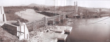
Album - Hume Reservoir Australia Album - General View of Works from New South Wales end, Looking Upstream, August 1927
This set of photos is from a leather bound album bearing the inscription "HUME RESERVOIR AUSTRALIA" plus 'The Rt. Hon. L. C. M. S. Amery, P. C., M .P.' all inscribed in gold. It was presented to The Rt. Hon. L. C. M. S. Amery, P. C., M. P, Secretary of State for Dominion Affairs on the occasion of his visit to the Hume Reservoir on 2nd November 1927. This album is of local and national significance as it documents the planning and development of the Hume Reservoir up to 1927. It was the largest water reservoir in the British Empire. The album records the pioneering engineering work that went into its construction.DEPARTMENT OF PUBLIC WORKS, N.S.W. RIVER MURRAY WATERS SCHEME. HUME RESERVOIR. 22. General View of Works from New South Wales end, Looking Upstream. Features: At the left, part of the North Wing Wall, the highest part of which is 26 feet below its ultimate height. Below in the foreground is the portion of the dam where provision is to be made for hydro-electric generation. The tubes, three in number, 13 feet in diameter, will be laid on the level shown and an early start will be made in laying them. The level for the other four regulating outlets, 9 feet in diameter, together with a part of the spillway section of the dam, is underwater at this stage and it may be remarked that at one point, about half way across the channel where the water is now flowing, the concrete foundations are about 80 feet below the level of the water. The broken surface of the water is due to the large “plums” in the concrete. The still water in the right foreground is the stilling pool over the concrete floor of which there is now more than 20 feet of water and by means of which the discharge from the outlet pipes will be quelled. The trestlework on the upstream side of the dam carries the concrete belt conveyor. It extends from the concrete mixer house, which is out of the picture, behind the wing wall, along almost the entire length of the concrete portion of the dam. The concrete is discharged from the belt at any desired point by means of trippers, one of which may be seen over the second trestle. On the other side of the flowing water is the coffer dam. A channel 300 feet wide involving about 140,000 cubic yards of excavation and dug for the temporary diversion of the river as it is flowing now. To the right top of the view beyond the Coffer Dam is the earth embankment being thrown across the major part of the valley by the Victorian Constructing Authority. The Mitta Mitta River flows into the Murray at the far end of the reach of water on the left. August 1927.hume reservoir australia, river murray waters scheme, hume reservoir construction -
 Federation University Historical Collection
Book, C.E. Bristow, Government Printer, Northern Territory of South Australia Government Geologist's Reports on Recent Mineral Discoveries, 1908
Foolscap government geologist's Report including information on:- Pine Creek District; Brock's Creek, Anson Bay, Northern Territory Boring Operations Images Include: 'Mob of Blacks ad Tamarind Tree near Cliff Head, Anson Bay; Diamond Drill Boring Camp, near Cliff Head, Anson Bay, Wannomi Swamp; Daly River Crossing; Battery and Chinese Miners, Driffield Sketch Plan of the Mount Davis Copper FIeld, Sketch Plan Shewing POsition of Mineral Localities and Claims Near Wolfram Camp, Sketch PLan of the Pin Creek District Shewing Metalliferous Localities. h.y.l. brown, mining, boring, aborigines, aboriginal, chinese, south australia -
 Bendigo Historical Society Inc.
Postcard - GLADYS DEAN COLLECTION: POSTCARD, 1906 - 1908
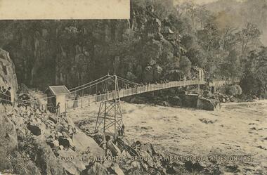
Printed black and white photographic postcard. Image is of a rocky gorge with a suspension bridge across the river below. A small wooden gatehouse is at one end and people are walking or standing at various points across the bridge and on the path in the distance. A white blank space is in the upper left hand corner of the image. A symbol of a diamond shape with the letters S C entwined, followed by the words No 76 Photoprint A Flood The Alexandra bridge. Cataract Gorge Launceston Tas are printed in white across the bottom edge. The numbers A10659 in white are printed in the lower left hand corner. The reverse is blank.Diamond shape with SC entwined No 76 Photoprint A 10659 The 'Wynphotoprint' Series published by Selwyn Cox Launceston Taspostcard -
 Bendigo Historical Society Inc.
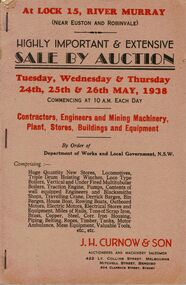
Document - IAN DYETT COLLECTION: AUCTION CATALOGUE - AT LOCK 15 - RIVER MURRAY
Auction catalogue with a beige cover with red and black printing for a sale on 24th, 25th and 26th May, 1938 of Contractors, Engineers and Mining Machinery, Plant, Stores, Buildings and Equipment at Lock 15, River Murray (Near Euston and Robinvale). J. H. Curnow & Son were the auctioneers. Catalogue has a column down the right side of the page to write in the price of each lot. Contains a description of some of the machinery, tools and buildings. Catalogue has a black and white photo of Lots 1667 to 1672, a 'Perry' Locomotive. Bolton Bros. Pty. Ltd. were the printers of the catalogue.business, auctioneers, j h curnow & son pty ltd, ian dyett collection - auction catalogue - at lock 15 - river murray, j h curnow & son, department of works and local government nsw, bolton bros pty ltd -
 Bendigo Historical Society Inc.
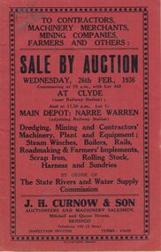
Document - IAN DYETT COLLECTION: AUCTION CATALOGUE - THE STATE RIVERS AND WATER SUPPLY COMMISSION
Red covered auction catalogue for a sale held on the 26th February, 1936 by Order of The State Rivers and Water Supply Commission at Clyde and the Main Depot at Narre Warren. For sale was Dredging,Mining and Contractors' Machinery, Plant and Equipment, Steam Winches, Boilers, Rails, Roadmaking & Farmers' Implements, Scrap Iron, Rolling Stock, Harness and Sundries. Columns to write prices on the right side edge of the pages. Hand written Supplementary List for Narre Warren Depot machine sewn inside the back cover. J. H. Curnow & Son were the auctioneers and the catalogue was printed by Boltons Print, Bendigo.business, auctioneers, j h curnow & son pty ltd, ian dyett collection - auction catalogue - the state rivers and water supply commission, j h curnow & son, boltons print bendigo -
Kew Historical Society Inc
Archive (series) - Subject File, ANDERSON, William Nicholls (1873-1927), 1958
Various PartiesReference, Research, InformationKHS Imposed OrderWilliam Nicholls Anderson (1873-1927) was an Australian painter, one of whose works from the 1906 series River + Rail is in the Kew Historical Society’s art collection (donated 1984). The archive file contains correspondence, biographical information (written by his niece), and locations in Kew where he lived. Much of the correspondence between the Society and the City of Kew relates to the painting and its location in the Mayor’s Room at the Kew Civic Offices in Charles Street, where it was on loan from the Society. Lucy M (Jean) Hornby, the artist’s niece was a resident of 5 and 20 Queen Street, Kew. william nicholls anderson, artists - kew (vic)william nicholls anderson, artists - kew (vic) -
 Kew Historical Society Inc
Print - Walmer Street Foot Bridge
A bridge to Walmer Street, Kew, from Abbotsford was located at the northern end of Burnley Street. It was a foot bridge.Photographic print of the Walmer Street Bridge. The view of the Bridge is from the Abbotsford side of the Yarra. A section of pipe on the near side of the bridge is a remnant of the irrigation pipes that carried water from above Dight's falls to the Melbourne Botanic Gardens. The former bridge, constructed in 1896 was swept away in the 1901 Flood. It has two major brick piers while the remainder of the trestle supports are metal. The original photograph from which this copy was made was taken after 1901 as it shows the second bridge under construction. Houses in Young Street, Kew, can be seen on the far side of the river.Written on reverse: "Walmer St. Bridge. Erected 1896. Being rebuilt after 1901 flood damaged it. Houses on left are in Young St."bridges -- kew (vic.), walmer street bridge, melbourne botanic gardens -
 Kew Historical Society Inc
Print - Walmer Street Foot Bridge, 1901
Photographic print of the Walmer Street Bridge. The view of the Bridge is from the Abbotsford side of the Yarra. A section of pipe on the near side of the bridge is a remnant of the irrigation pipes that carried water from above Dight's falls to the Melbourne Botanic Gardens. The former bridge, constructed in 1896 was swept away in the 1901 Flood. It has two major brick piers while the remainder of the trestle supports are metal. The original photograph from which this copy was made was taken after 1901 as it shows the second bridge under construction. Houses in Young Street, Kew, can be seen on the far side of the river.Reverse: " Walmer St footbridge 1901 being repaired after flood / Constructed 1892 substantially renewed in 1901 and in 1928 / Rebuilt in 1977 by Kew Council aided by State funding. Won for designer Martin Aylard a New Zealand award presented by the timber Research & Development Assoc / Site of Simpsons Road passenger foot ferry". bridges - yarra river -- kew (vic.), walmer street bridge -- kew (vic.) -
 Mont De Lancey
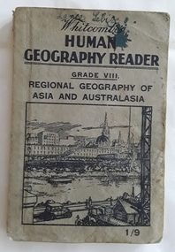
Book, Whitcombe & Tombs Limited, Whitcombe's Human Geography Reader Grade VIII - Regional Geography of Asia and Australasia, c 1930's
A Human Geography Reader for Grade VIII. Regional Geography of Asia and Australasia specially written to meet the requirements of the Social Studies (Geography) Course of Study in Victorian Schools. It stresses the necessity to win the interest of pupils and the important part geography has played in the history of the world. There is an emphasis on the regional study of Australasia.A small grey paperback reader or textbook with black lettering on the front cover at the top for the title Whitcombe's Human Geography Reader Grade VIII. A cost of 1/9 is printed in the lower right hand corner. A black and white illustration inside a square shape is of a city near a river and wharf activities. Throughout are black and white charts, maps, diagrams, photographs and illustrations. Inside the front and back covers are further Whitcombe and Tombs titles as well as on the outside of the back cover. Blue ink writing on the front of Lance Sebire. Some ink stains inside with a damaged worn cover and stains. 208p.non-fictionA Human Geography Reader for Grade VIII. Regional Geography of Asia and Australasia specially written to meet the requirements of the Social Studies (Geography) Course of Study in Victorian Schools. It stresses the necessity to win the interest of pupils and the important part geography has played in the history of the world. There is an emphasis on the regional study of Australasia.children's books, handbooks, textbooks, geography -
 Melbourne Tram Museum
Postcard, Biscay Greetings, Set of five photos of Melbourne trams, mid 1980's
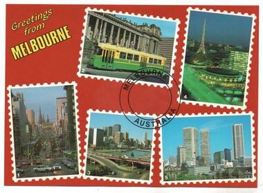
Colour postcard divided back - Biscay Greetings, series of 5 photographs of Melbourne, with the words "Greetings from Melbourne" in the top right hand corner. Features Z3 223 class tram outside Parliament, the Arts Centre, a view looking east along Bourke St, the Yarra River overlooking the King St bridge and the city and a general city photo. For the photo of Z3 223, see Reg item 2642. Back has space for name and address, stamp and a message and details of the postcard. Produced by Biscay Greetings, possibly mid 1980's. Card No. BG 178.trams, tramways, postcards, yarra river, z class, melbourne, tram 223 -
 Melbourne Tram Museum
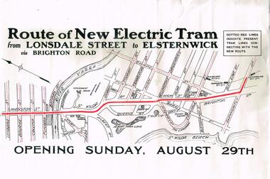
Poster, Melbourne & Metropolitan Tramways Board (MMTB), "Route of New Electric Tram from Lonsdale Street to Elsternwick via Brighton Road - Opening Sunday August 29th", Original 1926
Poster - special size, titled "Route of New Electric Tram from Lonsdale Street to Elsternwick via Brighton Road - Opening Sunday August 29th". Shows the tram rote in red and other tram lines dotted, including the Yarra River. Given its condition - a reproduction poster. From the Don Storey tram history notes - 1926 - 29 August - "he Elsternwick - St Kilda Junction line was opened, replacing the Brighton Road cable line together with an extension to Glenhuntly Road, and was built as double track." .1 - Laminated A3 version - added 30/6/2021trams, tramways, st kilda rd, brighton rd, lonsdale st, new tramway, conversion, elsternwick -
 Melbourne Tram Museum
Negative - Set of 2, Ellis Collection, c1940?
Set of two Negatives (120) of a wide body car crossing the Wallen St Road Bridge Hawthorn possibly after the construction of The Boulevard. Taken from either side of the river. Hi Res image filed in the dbtext/hawthtramcoll/Large Images/htd3595aLarge.jpg and htd3595bLarge A low resolution A4 laminated was received with the negatives. Image i2 - taken from Glan Avon Rd in Hawthorn of Wallen Rd bridge – the tram is one of three SW2 class trams (not the first one due to the door sizes, but one of 426, 432 or 478, most probably 478 as that was a Camberwell car)trams, tramways, wallen rd, bridges, sw2 class -
 Bendigo Military Museum
Map - TRENCH MAPS, FRANCE, 38th BN ON THE SOMME, 1).2) 1918, .3) system generated
The story covers mostly men of C Coy 38th Bn as well as others to give a broader pictutre. Edgar Stanbury MM as a C Coy Scout retrieved the maps from Capt G.A Dutton who was KIA. Stanbury then proceeded to keep reconnoitering towards Clery until they reached trenches near Clery Copse. The photos relate to the following, Jack Grinton, Bert Grinton, Edgar Stanbury, C.E. Newton, D.T.Hull, A.E.Pegler, Albert Gilhooley, C.E.A.Dunn, Hugh Pippin, G.A.Dutton, C.J.Holmes, Capt Selleck, Major Maudsley, last photo is labelled “Past Clery Copse”. Jack Grinton No 1043 C Coy, refer Cat No 1280. Bert Grinton No 5024 C Coy, awarded DCM 31.8.1918, refer Cat No 1320P. Edgar Stanbury No 997 C Coy, awarded MM 1917, WIA 2nd occasion 31.8.1918, refer Cat No 5032.3P. Charles Newton No 951 C Coy, awarded MM 26/31.8.1918. David Hull No 904 C Coy, Gassed 24.8.1918. Albert Gilhooley No 890 C Coy, KIA 31.8.1918, refer Cat No 5047. Augustus Pegler No 967 C Coy, awarded MM 31.8.1918. Cyril Dunn No 3058 7th Reo’s C Coy, KIA 31.8.1918. Hugh Pippin No 1895 2nd Reo’s C Coy, WIA 2nd occasion 11.8.1918, refer Cat No 1502. George Dutton Lieut No 532 C Coy, KIA 29.8.1918. (Photo of his name on Map & note to Jack Grinton) Charles Holmes No 910 C Coy, KIA 24.8.1918. (Photo of original grave) Horace Selleck Capt C Coy, KIA 19.7.1918, refer Cat No 1515. (Photo of address book) Arthur Fyfe No 1841 2nd Reo’s C Coy, KIA 30.8.1918. (Photo of original grave) Arthur Maudsley Major D Coy, KIA 31.8.1918. (Photo of original grave) Fyfe, Maudsley and Duttons graves are in the one photo. Last photo labelled “Past Clery Copse” This is the area where Bert Grinton is awarded the DCM on 31.8.1918, photo was taken by his brother Jack. .1) Map of France, trenches corrected to 15.4.1918, 1/20,000, Sheet 62D N.E, covers an area from Ribemont to Bray. .2) Map of France, trenches corrected to 6.3.1918, 1/20,000, sheet 62C N.W, covers area from Suzanne to Mt St Quentin. Both maps follow the Somme River. .3) Photo - story covers the events relating to the two maps from July 17th. - Sept 1st 1918 on the Somme . There are 14 photos with the story, 3 sections make up the story, Map 1, Map 2 and then details on the advance, the men, casualties and other.maps, 38th bn, c coy, the somme -
![Fern Bridge Gully, Black Spur / [by] Nicholas Caire, circa 1876](/media/collectors/550653872162f11fb04854aa/items/577b4c16d0cdd10948c8afab/item-media/577b4c75d0cdd10948c8ebe0/item-fit-380x285.jpg) Kew Historical Society Inc
Kew Historical Society IncPhotograph, Anglo-Australasian Photographic Company, Fern Bridge Gully, Black Spur, c. 1876
Nicholas Caire was born on Guernsey in the Channel Islands in 1837. He arrived in Adelaide with his parents in about 1860. In 1867, following photographic journeys in Gippsland, he opened a studio in Adelaide. From 1870 to 1876 he lived and worked in Talbot in Central Victoria. In 1876 he purchased T. F. Chuck's studios in the Royal Arcade Melbourne. In 1885, following the introduction of dry plate photography, he began a series of landscape series, which were commercially successful. As a photographer, he travelled extensively through Victoria, photographing places few of his contemporaries had previously seen. He died in 1918. Reference: Jack Cato, 'Caire, Nicholas John (1837–1918)', Australian Dictionary of Biography.An original, rare photograph from the series 'Views of Victoria: General Series' by the photographer, Nicholas Caire (1837-1918). The series of 60 photographs that comprise the series was issued c. 1876 and reinforced a neo-Romantic view of the Australian landscape to which a growing nationalist movement would respond. Nicholas Caire was active as a photographer in Australia from 1858 until his death in 1918. His vision of the Australian bush and pioneer life had a counterpart in the works of Henry Lawson and other nationalist poets, authors and painters.Views of Victoria (General Series), No.22 / ‘Fern Bridge Gully, Black Spur’ / Albumen silver photograph mounted on boardInscription on reverse: 'Fern Bridge Gully is situated near the summit of the Black Spur, about two miles from Fernshawe. Here the foliage is exceedingly dense, so much so as to exclude daylight in many places. This stream has derived its name from the fact of the Bridge having been constructed of large massive fern tree. The stream which flows beneath the Bridge is one of the sources of the River Watt.’nicholas caire (1837-1918), australia - landscape photography -
 Melbourne Tram Museum
Slide - Set of 7, Keith Caldwell, 11/03/1962 12:00:00 AM
Set of 7 Agfa Colour slides, cardboard mounts, by Keith Caldwell dated 11.3.1962 of the transfer of cars from Footscray to the "Main System" the day after the system was closed. See Keith Kings history of Footscray notes. All trams running trolley wheels. .1 - Footscray depot cars X1 463, X2 678, X1 460 and X1 466 in Gordon St, about to turn into River Street. .2 - X2 678 turning from Nicholson St into Irving St. Footscray with the Rockmans Store in the background. This store was later demolished for the Ring Road. Also is J. Boltons Chemist shop advertising Kodak film and another shop advertising Darrell Lea Chocolates, Peters Icecream and ? Lopes fruit shop. .3 - X1 460 at same location. .4 - X2 678 crossing Maribyrnong River Bridge - note the person crouching down on the south side of the bridge behind the tram. .5 - X1 460 in Rosamond Road, just before the curve onto Williamson Rd. This site became the Bunnings site. The tram has a modified 21E truck. .6 - X2 468 as above with part of the curve in the view. Has an advertisement for Bon Stores of Hopkins St Footscray. .7 - X2 678 at ditto..1 - in ink - "Farewell Footscray" Sun 11.3.1962 - Footscray Depot cars departing areas en route to Main system." .2 - .7 all have "Footscray Sun 11.3.62"trams, tramways, footscray, closure, maribyrnong, gordon st, river st, irving st, maribyrnong river, bridges, x1 class, x2 class, rosamond rd, 21e trucks, tram 463, tram 678, tram 460, tram 466 -
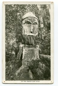 Orbost & District Historical Society
black and white photograph, 1920s
Pons asinorum was the name given to a wooden carving made by road worker Finlay Munro in the early 1920s at Boulder Creek, on the old Princess Highway, between Orbost and Cann River. The carved face was said to mock the supervising engineer after an argument about putting the road alignment across a swamp that required new bridges. The Italian workmen had advocated for a different route to avoid the need for building new bridges across the swamp. This photograph is from a set of thirteen black and white postcards in a fold-out format.This is a photograph of an iconic tourist attraction which records the woodworking skills of workers in the early 20th century. The carving is no longer there.A small black / white photograph of a face carved into a tree stump.on front at bottom - ON THE ORBOST CANN ROADwoodcarving pons-asinorum boulder-creek-east-gippsland princess-highway -
 Warrnambool and District Historical Society Inc.
Book, Frank, Late 19th century
This book was given as a prize in 1892 to Joseph Cassady from the Cassady’s Bridge State School. This school, once located near Cassady’s Bridge on the present-day Caramut Road, was opened on 19th January 1891 and closed in December 1892. The first teacher was Janet Ada McDougall and the teacher when the school closed was J. H. Delahenty. The Cassady family had the farm, Boughton and this was established about 1845 on the Merri River near where the bridge is today. Joseph was born in 1882 to William and Elizabeth Cassady.This book is of considerable importance as it is the only memento we have of Cassady’s Bridge State School. This school only existed for two years.This is a hard cover book of 208 pages. The cover is green with coloured borders and a coloured sketch of a stream and a bridge. The lettering on the front cover and the spine is gold and the pages are gilt-edged. The cover is much faded. Some of the back pages are partly torn away. The book has two black and white sketches at the front of the book and 28 chapters of story. The inscription is handwritten in black ink and the inscription page is stained. ‘State School Cassady’s Bridge Xmas 1892 Presented to Joseph Cassady 3rd Class for Good Progress. J.H. Delahenty Head Teacher’ cassady family, boughton, history of warrnambool -
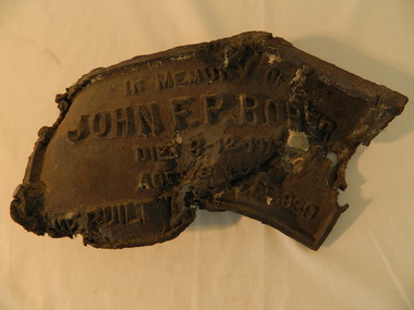 Kiewa Valley Historical Society
Roper's Hut Memorabilia
Roper's Hut was built in 1939 and was burnt down in 2003. It was rebuilt in 2008 and is situated on the Bogong High Plains on Duane Spur (where Duane's hut had been before it too was destroyed by (1939) bushfires, between Mt Nelse and Big River. The original hut was used as a shelter for cattlemen who grazed their cattle on the High Plains during summer. The Victorian High Country Huts Association Inc. members and friends helped rebuild the hut which is now used as an emergency shelter for visitors to the High Plains.The memorabilia is significant as the items belonged to the Roper family who were one of the original settlers of the Kiewa Valley and one of the original families who drove their cattle up to the Bogong High Plains. The burnt plaque and forks and the rebuilding of the huts (Duane's & Roper's) are significant as bush fires are a constant threat to the Bogong High Plains destroying large areas at a time.1. Bronze Plaque and 2 damaged forks from Roper's Hut which was destroyed by bush fires in 2003. 2. DVD & USB and hard copy photos of the rebuild of Roper's Hut in January 2008.The plaque had 'In Memory of / John F. P. Roper/ died 3-12-1977 / Aged 78 years / He built the original hut Feb. 1939'roper's hut, cattlemen, bogong high plains, bronze plaque, roper family, bush fires -
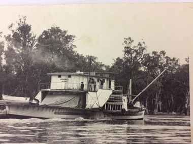 Port of Echuca
Black and white rectangular photograph, 1950?
The paddle steamer P. S Pevensy appears to still be a working steamer in this photograph. The boat seems a bit dishevelled and the workers are doing repairs on her, while she is still steaming up the river. If this photograph was taken in 1950, that would have been well before the development of the Tourism Industry in the Murray Darling area. This would explain the number of workers and the fact that they were doing maintenance while the Paddle Steamer was still working. She does not appear to be towing a barge, but a large tarpaulin could be covering a load for transport. This picture holds significance because it shows a paddle steamer in use before the Tourism Industry had developed in the Murray Darling region. The paddle steamer which now carries passengers every day has been renovated to cater for passengers cruising up and down the river. Here is this photograph the P.S Pevensy looks a bit dishevelled and untidy.This is a black and white rectangular photograph of the P.S Pevensey. Four people can be seen painting the wall of the cabins on the upper deck. A person can also be seen kneeling on the back deck working on something lying on the back deck. A wooden boat is nearby, also on the back deck. The boat is steaming and appears to be moving upstream. There is along pole at a 45 degree angle attached to the very front of the paddle steamer.On the front of the photograph written on the paddle steamer can't be seen the words "PEVENSEY. Melbourne." Written on the back of the photograph in lead pencil " M4414-17. K4". p.s pevensey, paddle steamers -
 Eltham District Historical Society Inc
Negative - Photograph, J.A. McDonald, Eltham-Yarra Glen Road, Lower Plenty, c. July 1962
View looking west across the Eltham-Yarra Glen Road approaching the Lower Plenty Bridge near turn-off for the Golf Club Hotel. Present-day Lower Plenty Road follows a revised alignment across a new bridge. The former bridge is now part of the Plenty River Trail and Edward Willis Court now follows this section of the original Eltham-Yarra Glen Road.. The Golf Club Hotel is gone and a new Lower Plenty Hotel was built slightly further up the hill.Record of various Shire of Eltham infrastructure works undertaken during the period of 1952-1962 involving bridge and road reconstruction projects, sometimes with Eltham Shire Council Project Reference numbers quoted. It was during this period that a number of significant improvements were made to roads and new bridges constructed within the shire that remain in place as of present day (2022). In many situations, the photos provide a tangible visible record of infrastructure that existed throughout the early days of the Shire. The album was put together by or under the direction of the Shire Engineer, J.A. McDonald.1962-07, shire of eltham, old eltham road, edward willis court, eltham-yarra glen road, golf club hotel, infrastructure, lower plenty, road construction -
 Waverley RSL Sub Branch
Plaque HMAS Stuart, HMAS Stuart
HMAS Stuart (D00), an Admiralty type destroyer leader, launched in 1918 for the Royal Navy. She was transferred to the RAN in 1933, and served during World War II. The ship was paid off in 1946, and sold for scrap. HMAS Stuart (DE 48), one of six River class destroyer escorts (based on the British Type 12 frigate) built for the RAN. She was commissioned in 1963, paid off in 1991, and sold for scrap. HMAS Stuart (FFH 153), an Anzac class frigate commissioned in 2002 and active as of 2012Wooden Plaque 15cm x 13cmHMAS Stuart -
 Waverley RSL Sub Branch
Plaque H.M.A.S. Stuart, H.M.A.S. Stuart
HMAS Stuart (D00), an Admiralty type destroyer leader, launched in 1918 for the Royal Navy. She was transferred to the RAN in 1933, and served during World War II. The ship was paid off in 1946, and sold for scrap. HMAS Stuart (DE 48), one of six River class destroyer escorts (based on the British Type 12 frigate) built for the RAN. She was commissioned in 1963, paid off in 1991, and sold for scrap. HMAS Stuart (FFH 153), an Anzac class frigate commissioned in 2002 and active as of 2012Wooden Plaque 15cm x 13cm with insignia of H.M.A.S. Stuart H.M.A.S. Stuart -
 Greensborough Historical Society
Document - Certificate of Title, Flintoff land, 1897o
1. Certificate of Title: Edith Flintoff 26/10/1897: Vol. 2659 Fol.531750. 2. Transfers of (1) Edith Flintoff, Edith Fullwood, John Bosch. 3. List of transfers from Frederick Nevins Flintoff including to Robert Whatmough and John McLaughlin. 4. Plenty River to Diamond Creek Road (plan) shows land belonging to Edith Flintoff, Edith Fullwood, John Bosch. 5. Register of proprietors including Edith Flintoff of Nillumbik, Portion 14, Vol. 2659 Fol.531750.Shows part of the chain of ownership of this parcel of land in Greensborough.5 pages. Copies of land titles and associated documentsflintoff family, land titles - greensborough -
Greensborough Historical Society
Folder, Chapman family (James Chapman), 1849o
History of the origins of this Greensborough family and the family tree of James Chapman (1805-1875) and Susan Palmer (1808-1895). James Chapman, his wife Susan and all his family including his son-in-law William Poulter left the Port of London in November 1848 on board the 'Francis Ridley' of 536 tons on her maiden voyage to Australia and Bombay India. The Master of the ship was Henry Hudson. James Poulter owned the land between Greensborough Railway Station and Plenty River before selling it to William Poulter.20-page plastic binder, spiral bound, clear cover. Contains documents relating to the James Chapman family.chapman family, james chapman, susan palmer -
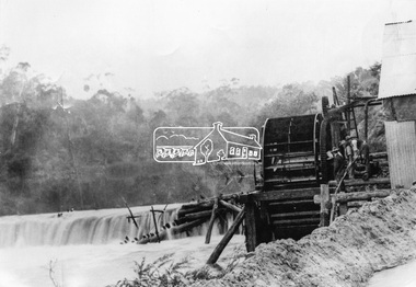 Eltham District Historical Society Inc
Photograph, Remains of the old Water Wheel and Battery, Warrandyte, 1934
A short distance upstream from the old wooden Warrandyte Bridge, the Yarra river was at one time dammed to give power to a large wooden waterwheel which drove a plant for crushing gold. Up until around 1908 the waters of the Yarra, pent up by a stone weir, forced their way past this old wheel turning it to crush the precious quartz. In 1925 the reamins of the State Battery were removed. The large water wheel (thanks to the forethought of a local resident, Mr. P. Mackie) was left in its position.This photo forms part of a collection of photographs gathered by the Shire of Eltham for their centenary project book,"Pioneers and Painters: 100 years of the Shire of Eltham" by Alan Marshall (1971). The collection of over 500 images is held in partnership between Eltham District Historical Society and Yarra Plenty Regional Library (Eltham Library) and is now formally known as the 'The Shire of Eltham Pioneers Photograph Collection.' It is significant in being the first community sourced collection representing the places and people of the Shire's first one hundred years.Digital image 4 x 5 inch B&W Negshire of eltham pioneers photograph collection, warrandyte, water wheel, caledonia battery, state battery, warrandyte battery -
 Eltham District Historical Society Inc
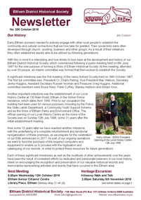
Newsletter, Newsletter, No. 230 October 2016
Contents: • Our History by Jim Connor • Our Next Meeting - Wednesday 12th October • Heritage Excursion - Kileavey Walk and Talk - Saturday 5th November • The Festive Reason by Mal Harrop • History of Maroondah Aqueduct Pipe Bridge over the Plenty River at Greensborough by Anne Paul • One Hundred Years Ago: Eltham and District - July-December 1916 by Liz Pidgeon • From the Hurstbridge Advertiser 2 March 1923 • Refurbishment of our Local History Centre • ... and also • Contacts for the Eltham District Historical Society The Shire of Eltham Historical Society was formed in October 1967. The first newsletter of the Society was issued May 1978 and has been published continuously ever since on a bi-monthly basis. With the cessation of the Shire of Eltham in late 1994, the Society's name was revised to Eltham District Historical Society and this name first appeared with issue No. 103, July 1995. The collection of the Society's newsletters provides a valuable resource on the history of the Society's activities, office bearers and committee members, guest speakers and subjects of historical interest pertinent to the former Shire of Eltham and the Eltham District.A4 photocopied newsletter distributed to membersnewsletter, eltham district historical society, shire of eltham historical society -
 Kiewa Valley Historical Society
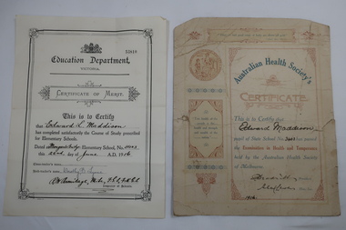
Papers - Certificates - Edward Maddison
The Australian Health Society was formed in Melbourne in 1875 at the instigation of Unitarian Minister MarthaTurner. It promoted hygiene and comprised of doctors, prominent citizens and politicians. It targeted poorer districts and women. Schools were pressured to place health education on the curriculum. Society stalwarts made an annual examination in state schools. Mongan's Bridge No. 3403 opened in 1902. It was located beside the Kiewa river and operated part-time with nearby schools on occasions as well as full time. As numbers fluctuated it was also closed on occasions and then re-opened.Edward Maddison's family were farmers in the Kiewa Valley and the children attended the local school.Two certificates belonging to Edward Maddison 1. 1916 Pupil of State School No 3403 (Mongan's Bridge) - passed the Examination in Health and Temperance held by the Australian Health Society of Melbourne 2. 1916 Completed satisfactorily the Course of Study prescribed for Elementary Schools.- Mongan's Bridge Elementary School No. 3403edward maddison, australian health society, mongan's bridge school -
 Kiewa Valley Historical Society
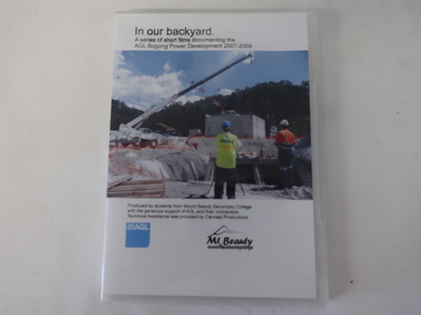
DVD - AGL Bogong Power Development & 6 DVDs with students contributions, In Our Backyard
Students from Mt Beauty Secondary College produced this set of 3 DVDs re the development of AGL's Bogong Power Development 2007-2009. This was an addition to the Kiewa Hydro Electric Scheme built by the SECV in the 1950s. The information covers many aspects of the Development which is of interest as well as being educational for the students. The request re the SECV Adit Shaft was to assist with the information board beside the shaft on the Gorges Walk on the West Kiewa River. DVDs were a digital means of passing on information to an audience and enabled multiple copies to be made. The Kiewa Hydro Electric Scheme is in the Kiewa Valley producing clean energy for Victoria. The Bogong Power Development increased the production of electricity in line with more clean energy and gave locals employment and students an insight into its construction and issues. The technical aspect of using DVDs to present this knowledge was also part of the education for the local students. x3 DVDs with hard clear plastic box cover. The cover has a photo on the front with the title typed above it and production details below along with the AGL logo and its Mt Beauty logo.On the back the details (title and content) for each of the 3 DVDs is given. DVD Stories: 1, 2, 4, 7 & 8 and DVD "AGL Photos West Kiewa - In response to letter re photos of Adit Shaft. July 2013"bogong power development project, mt beauty secondary college 2007-2009, agl -
 Kiewa Valley Historical Society
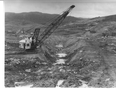
Photograph Rocky Valley Dam Excavations, Rocky Valley Dam Wall Excavation, c1947-48
Work commenced at Rocky Valley Dam site in early 1947 and proceeded until May. Resumed work in October after the winter and a camp for the accommodation of workmen was commenced at this time. Work continued in 1948 with the establishment of work facilities, including the erection of two large excavators. At the dam site the river was diverted through a temporary pipeline. Work proceeded in the summer months with the placing of concrete in the foundations and earth and rock fill for the construction of the wall. Rocky Valley and associated spillway and outlet works were completed in March, 1959. A very good representation of the type of machinery available in the 1940's used for excavation of the dam and the construction of the dam wall.Black and white photograph of Rocky Valley Dam wall under construction. There are at least three cranes plus workmen in the photo. This is taken from the Heathey's Spur side of the dam wall looking back toward Sun Valley.Hand written on back of photograph "Rocky Valley Dam Wall Excavation" in blue ink.rocky valley, dam, wall, machinery -
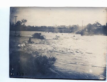 Orbost & District Historical Society
black and white photograph, January 1934
From The Argus (Melbourne) on January 10 1934 "Damage estimated at £500,000 has been caused by the floods in the Orbost district. No loss of life occurred, largely owing to the heroic efforts of rescue parties. Many families spent Monday night on the roofs of houses or in trees, surrounded by deep, rushing flood waters." This 1934 flood was devastating, destroying a section of the 1922 Orbost bridge - the centre span was washed away -. wrecking fences, bridges and roads, dumping silt and debris on the rich river flats and drowning cattle. This is a pictorial record of the 1934 flood, a significant event in the history of Orbost.A black / white photograph of floodwaters. In the middle of the water can be see debris including a large spoked wheel. In the background are houses and fences.on back - "near Hilyer's garage at foot of hill Main Street Caravan Park on right" on front at bottom left - "1934"orbost-flood-1934 flood-orbost