Showing 8861 items matching " construction"
-
 Kiewa Valley Historical Society
Saucer Ceramic, from 1921 to 1961
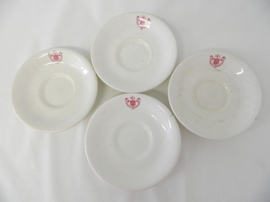
This item was used by the State Electricity Commission of Victoria in their mess rooms for their workers during the construction of the Kiewa Hydro Electricity Scheme. The imprint of the year "1921" was to identify the year that the SECV was formed and relieved the private VHEC(Victorian Hydro-Electric Company). As the scheme was of such a huge, isolated and time consuming nature the feeding of its workers was quite demanding of cutlery and crockery. The use of sturdy English cups and saucers was essential. The period of construction and the isolation of the Kiewa Valley area placed heavy demand for "solid" crockery that could wear abusive handling. This period in time was one when crockery, whether for domestic or commercial use, was imported from "mother" England. This scenario was more so for governmental bodies such as rail, jails and electricity providers than domestic users. The influx of cheaper Asian crockery had not yet begun.This type of crockery item was used by the thousands of SEC Victorian staff and construction workers involved in the building of the Kiewa Hydro Electricity Scheme, over the extensive period (1938 to 1961). This was a period when Government bodies and other semi- government organisations were still tied to the "establishments" of "mother" England. It was a period in Australia's development when the Asian influence was very weak and the established ties to England and Europe was still very strong. The majority of heavy equipment and machinery was either made in England or Europe. Local/European expertise in dam construction and water management in alpine terrain came from migrants or English and European specialist. The quality of workmanship from big steel manufacturing plants in England and Europe could not be matched from anywhere else in the developed world.This item is a white ceramic saucer (tea /coffee). It is made in England and is of strong and durable ceramic. The bottom cup indent is for either tea or coffee cups of a similar ceramic structure. The 5mm thickness of the ceramic suggests this saucer belongs to a commercial kitchen environment and not domestic. The indent bottom of the saucer is 5mm deep with a side curvature ratio of 2:5. The ceramic is glazed to a commercial standard (worker's mess). See also KVHS 0128 (A,C and D) The seal of the State Electricity Commission Of Victoria is imprinted on the top inside rim within a curved scroll. Snuggled within the borders of the scroll is a banner with the five stars of the southern cross and an arm with a closed fist projecting from the top with five lightning bolts projecting outwards. On the underside "Vitrified sold by Cafe & Hotel Supplies Pty Ltd Dunn Bennett & Co. Ltd. Burslem Made in England"saucer, plate, secv, state electricity commission of victoria, crockery, mt beauty chalet, bogong mess hall -
 Kiewa Valley Historical Society
Saucer Ceramic, from 1921 to 1961
This item was used by the State Electricity Commission of Victoria in their mess rooms for their workers during the construction of the Kiewa Hydro Electricity Scheme. The imprint of the year "1921" was to identify the year that the SECV was formed and relieved the private VHEC (Victorian Hydro-Electric Company). As the scheme was of such a huge, isolated and time consuming nature the feeding of its workers was quite demanding of cutlery and crockery. The use of sturdy English cups and saucers was essential. The period of construction and the isolation of the Kiewa Valley area placed heavy demand for "solid" crockery that could wear abusive handling. This period in time was one when crockery, whether for domestic or commercial use, was imported from "mother" England. This scenario was more so for governmental bodies such as rail, jails and electricity providers than domestic users. The influx of cheaper Asian crockery had not yet begun.This type of crockery item was used by the thousands of SEC Victorian staff and construction workers involved in the building of the Kiewa Hydro Electricity Scheme, over the extensive period (1938 to 1961). This was a period when Government bodies and other semi- government organisations were still tied to the "establishments" of "mother" England. It was a period in Australia's development when the Asian influence was very weak and the established ties to England and Europe was still very strong. The majority of heavy equipment and machinery was either made in England or Europe. Local/European expertise in dam construction and water management in alpine terrain came from migrants and specialist recruited from England and Europe. The quality of workmanship from big steel manufacturing plants in England and Europe could not be matched from anywhere else in the developed world.This item is a white ceramic saucer (tea /coffee). It is made in England and is of strong and durable ceramic. The bottom cup indent is for either tea or coffee cups of a similar ceramic structure. The 5mm thickness of the ceramic suggests this saucer belongs to a commercial kitchen environment and not domestic. The indent bottom of the saucer is 5mm deep with a side curvature ratio of 2:5. The ceramic is glazed to a commercial standard (worker's mess). See also KVHS 0128 ( A,B&D)The seal of the State Electricity Commission Of Victoria is imprinted on the top inside rim within a curved scroll. Snuggled within the borders of the scroll is a banner with the five stars of the southern cross and an arm with a closed fist projecting from the top with five lightning bolts projecting outwards. On the underside "Vitrified sold by Cafe & Hotel Supplies Pty Ltd Dunn Bennett & Co. Ltd. Burslem Made in England"saucer, plate, secv, state electricity commission of victoria, crockery, mt beauty chalet, bogong mess hall -
 Kiewa Valley Historical Society
Photograph of Lake Guy and Bogong Village, Lake Guy and Bogong Village, Approx. 1945
In 1940 Field Headquarters for the Kiewa Scheme were established at Bogong with office, workshop facilities and accommodation for workmen, staff and some families constructed. (There had been a 'tent camp' on this site in 1939 but was destroyed by bushfires) Construction of accommodation continued until 1947. A total of 40 houses plus a hostel for single staff, post office, police station, medical centre and primary school all with water and sewerage and electricity supply. The staff hostel was known as Kiewa House and is now occupied by the Education Department. Lake Guy was named after Mr. L.T. Guy who was the Resident Engineer in charge of construction work and associated activities on the Kiewa area. He held this position from 1939 to November 1946 when he was transferred to Head Office.This photograph is an excellent historical record of Bogong Village in about 1945. It shows the layout of the town in the fairly steep terrain, the workmen's camp between the houses and the lake foreshore, the Commissioner's Lodge on the hill behind the Village, the walkway through the dam wall can be seen to the left of the spillway, the dam is on spill and note damage to the large trees is still evident from the 1939 bush fires. The Commissioner's Lodge was lost in the 2003 fires and the camp buildings were in service until 1962, when they were removed and the site converted into a public picnic area with lawns and gardens.A Black and white photograph"Lake Guy and Bogong" hand written on back of photograph.kiewa, accommodation, lake, dam, bogong -
 Unions Ballarat
Stop the ABCC: Turnbull's War on Workers (bumper sticker), 2018
The ABCC (Australian Building and Construction Commission) was first created during the government of John Howard (LNP). The ABCC claims to, "ensuring that building work in Australia is carried out fairly, efficiently and productively—for the benefit of all employers and workers in the industry, and for the benefit of the Australian economy as a whole." Conversely, the organisation has been claimed by unions and workers to be anti-union and detrimental to the working conditions of employees. A fact sheet from the CFMMEU is attached to this entry. Malcolm Turnbull was Prime Minister from 2015 to 2018. He became Prime Minister after deposing Tony Abbott, in a leadership challenge. The bumper sticker was produced by CFMMEU during the Turnbull Prime Ministership (2015-2018). The CFMMEU is one of the largest unions; membership coverage includes construction, forestry, maritime, mining, energy, textile, clothing and footwear production. Relevant to government, industrial relations and trade unions in Australia.Bumper sticker: colour picture of Malcolm Turnbull; red and white lettering. Stop the ABCC: Turnbull's War on Workers Subtext: exploits workers; destroys jobs; lies; attacks safety; ignores big business; union bashing; CFMEU.btlc, ballarat trades hall, ballarat trades and labour council, cfmeu, turnbull, malcolm, prime ministers - australia, liberal party australia, abcc, australian building and construction commission, industrial relations, cfmmeu, construction, forestry, maritime, mining and energy union, construction, forestry, mining and energy union, trade unions - australia -
 Kew Historical Society Inc
Photograph - Yarra Valley Floods: Kew East, 1916
Flooding of the Yarra Valley, including that section of the Yarra bordering Kew and Kew East in the north and west of the municipality, was a regular occurrence. Extreme flood events of the Yarra River are recorded to have occurred in 1891, 1901, 1916, 1923 and 1934. The Municipality of Kew's response to these floods was to enact planning decisions restricting residential development in flood prone areas following the floods of 1916, 1921 and 1934. While floods continued after the development of the Upper Yarra Reservoir (construction 1948-57), the regularity and extent of these inundations diminished. During the nineteenth century, the land abutting the south side of the Yarra in Kew was devoted to dairy farming. In the twentieth century, before and after the construction of the Eastern Freeway, much of this low-lying area was used as golf courses and public parks.One of a collection of photographs of flooding in the Kew section of the Yarra Valley which are in important research resource for the location and extent of flooding in the first half of the twentieth century. Flooding of the Yarra Valley at East Kew in 1916. The view is taken from the intersection of Kilby Road with what is believed to be Birdwood Street, looking across the flood waters to Ivanhoe. The extensive flooded area shown in the photograph would have included the Kew Golf Club. Verso: "Floods along Kilby Road / near Birdwood St? & Kilby Road / 1917? / 87yarra river, yarra valley, floods -- kew, kilby road -- kew (vic.), kew golf club -
 Kew Historical Society Inc
Photograph - Yarra Valley Floods: Kew East, 1916
Flooding of the Yarra Valley, including that section of the Yarra bordering Kew and Kew East in the north and west of the municipality, was a regular occurrence. Extreme flood events of the Yarra River are recorded to have occurred in 1891, 1901, 1916, 1923 and 1934. The Municipality of Kew's response to these floods was to enact planning decisions restricting residential development in flood prone areas following the floods of 1916, 1921 and 1934. While floods continued after the development of the Upper Yarra Reservoir (construction 1948-57), the regularity and extent of these inundations diminished. During the nineteenth century, the land abutting the south side of the Yarra in Kew was devoted to dairy farming. In the twentieth century, before and after the construction of the Eastern Freeway, much of this low-lying area was used as golf courses and public parks.One of a collection of photographs of flooding in the Kew section of the Yarra Valley which are in important research resource for the location and extent of flooding in the first half of the twentieth century. Flooding of the Yarra Valley at East Kew in 1916. The view is taken from a street (maybe Birdwood Avenue) intersecting with Kilby Road looking northeast across the flood waters to Ivanhoe and Heidelberg. The extensive flooded area shown in the photograph would have included remnant dairy farms and the Kew Golf Club. Verso: "Floods / Yarra River / East Kew / Kilby Road / 1917? / 87"yarra river, yarra valley, floods -- kew, kilby road -- kew (vic.), kew golf club -
 Kew Historical Society Inc
Photograph - Flooding of the Yarra Valley at Kew East, 1974
Flooding of the Yarra Valley, including that section of the Yarra bordering Kew and Kew East in the north and west of the municipality, was a regular occurrence. Extreme flood events of the Yarra River are recorded to have occurred in 1891, 1901, 1916, 1923 and 1934. The Municipality of Kew's response to these floods was to enact planning decisions restricting residential development in flood prone areas following the floods of 1916, 1921 and 1934. While floods continued after the development of the Upper Yarra Reservoir (construction 1948-57), the regularity and extent of these inundations diminished. During the nineteenth century, the land abutting the south side of the Yarra in Kew was devoted to dairy farming. In the twentieth century, before and after the construction of the Eastern Freeway, much of this low-lying area was used as golf courses and public parks.Late example of the capacity of the Yarra Valley at Kew to flood, even though drainage works and the Upper Yarra Reservoir had reduced their regularity.Original black and white print photograph of the low-lying land at East Kew under floodwater on 16 May 1974. The vantage point of the photographer is Lister Street. In the photo, the fences of the Kilby Farm can be seen. Flooding was caused by overflowing water in Glass' Creek and the River Yarra. Annotation verso: "Hay's Paddock op No.30 Lister Street / 16 May 1974 11.50am / R.L. 46.04"hays paddock, floods, yarra river, glass' creek, lister street -
 Kew Historical Society Inc
Photograph - Flooding of the Yarra Valley at Kew East, 1974
Flooding of the Yarra Valley, including that section of the Yarra bordering Kew and Kew East in the north and west of the municipality, was a regular occurrence. Extreme flood events of the Yarra River are recorded to have occurred in 1891, 1901, 1916, 1923 and 1934. The Municipality of Kew's response to these floods was to enact planning decisions restricting residential development in flood prone areas following the floods of 1916, 1921 and 1934. While floods continued after the development of the Upper Yarra Reservoir (construction 1948-57), the regularity and extent of these inundations diminished. During the nineteenth century, the land abutting the south side of the Yarra in Kew was devoted to dairy farming. In the twentieth century, before and after the construction of the Eastern Freeway, much of this low-lying area was used as golf courses and public parks.Late example of the capacity of the Yarra Valley at Kew to flood, even though drainage works and the Upper Yarra Reservoir had reduced their regularity.Original black and white print photograph of the low-lying land at East Kew under floodwater on 16 May 1974. The vantage point of the photographer is Lister Street. Flooding was caused by overflowing water in Glass' Creek and the River Yarra. Annotation verso: "Lister Street looking north / Flood level / 16 May 1974 11.30am / R.L. 46.04"hays paddock, floods, yarra river, glass' creek, lister street -
 Kew Historical Society Inc
Photograph - Flooding of the Yarra Valley at Kew East, 1974
Flooding of the Yarra Valley, including that section of the Yarra bordering Kew and Kew East in the north and west of the municipality, was a regular occurrence. Extreme flood events of the Yarra River are recorded to have occurred in 1891, 1901, 1916, 1923 and 1934. The Municipality of Kew's response to these floods was to enact planning decisions restricting residential development in flood prone areas following the floods of 1916, 1921 and 1934. While floods continued after the development of the Upper Yarra Reservoir (construction 1948-57), the regularity and extent of these inundations diminished. During the nineteenth century, the land abutting the south side of the Yarra in Kew was devoted to dairy farming. In the twentieth century, before and after the construction of the Eastern Freeway, much of this low-lying area was used as golf courses and public parks.Late example of the capacity of the Yarra Valley at Kew to flood, even though drainage works and the Upper Yarra Reservoir had reduced their regularity.Original black and white print photograph of Hay's Paddock under floodwater on 16 May 1974. The vantage point of the photographer is Keystone Crescent looking east. Flooding was caused by overflowing water in Glass' Creek and the River Yarra. Annotation verso: "Keystone Cr looking east / 16 May 1974 11.50am"hays paddock, floods, yarra river, glass' creek -
 Kew Historical Society Inc
Photograph - Flooding of the Yarra Valley at Kew East, 1974
Flooding of the Yarra Valley, including that section of the Yarra bordering Kew and Kew East in the north and west of the municipality, was a regular occurrence. Extreme flood events of the Yarra River are recorded to have occurred in 1891, 1901, 1916, 1923 and 1934. The Municipality of Kew's response to these floods was to enact planning decisions restricting residential development in flood prone areas following the floods of 1916, 1921 and 1934. While floods continued after the development of the Upper Yarra Reservoir (construction 1948-57), the regularity and extent of these inundations diminished. During the nineteenth century, the land abutting the south side of the Yarra in Kew was devoted to dairy farming. In the twentieth century, before and after the construction of the Eastern Freeway, much of this low-lying area was used as golf courses and public parks.Late example of the capacity of the Yarra Valley at Kew to flood, even though drainage works and the Upper Yarra Reservoir had reduced their regularity.Original black and white print photograph of the low-lying land at East Kew under floodwater on 16 May 1974. The vantage point of the photographer is Lister Street. Flooding was caused by overflowing water in Glass' Creek and the River Yarra. Annotation verso: "Lister St looking same as No.3 / 16 May 1974 11.30"floods, yarra river, glass' creek, lister street -
 Kew Historical Society Inc
Photograph - Flooding of the Yarra Valley at Kew East, 1974
Flooding of the Yarra Valley, including that section of the Yarra bordering Kew and Kew East in the north and west of the municipality, was a regular occurrence. Extreme flood events of the Yarra River are recorded to have occurred in 1891, 1901, 1916, 1923 and 1934. The Municipality of Kew's response to these floods was to enact planning decisions restricting residential development in flood prone areas following the floods of 1916, 1921 and 1934. While floods continued after the development of the Upper Yarra Reservoir (construction 1948-57), the regularity and extent of these inundations diminished. During the nineteenth century, the land abutting the south side of the Yarra in Kew was devoted to dairy farming. In the twentieth century, before and after the construction of the Eastern Freeway, much of this low-lying area was used as golf courses and public parks.Late example of the capacity of the Yarra Valley at Kew to flood, even though drainage works and the Upper Yarra Reservoir had reduced their regularity.Original black and white print photograph of the low-lying land at East Kew under floodwater on 16 May 1974. The vantage point of the photographer is at Willsmere Road. The road itself is underwater.Annotation verso: "Willsmere Rd / Same as No.7 / 16 May 1974 11.15am"floods, yarra river, willsmere road -
 Kew Historical Society Inc
Photograph - Flooding of the Yarra Valley at Kew East, 1974
Flooding of the Yarra Valley, including that section of the Yarra bordering Kew and Kew East in the north and west of the municipality, was a regular occurrence. Extreme flood events of the Yarra River are recorded to have occurred in 1891, 1901, 1916, 1923 and 1934. The Municipality of Kew's response to these floods was to enact planning decisions restricting residential development in flood prone areas following the floods of 1916, 1921 and 1934. While floods continued after the development of the Upper Yarra Reservoir (construction 1948-57), the regularity and extent of these inundations diminished. During the nineteenth century, the land abutting the south side of the Yarra in Kew was devoted to dairy farming. In the twentieth century, before and after the construction of the Eastern Freeway, much of this low-lying area was used as golf courses and public parks.Late example of the capacity of the Yarra Valley at Kew to flood, even though drainage works and the Upper Yarra Reservoir had reduced their regularity.Original black and white print photograph of the low-lying land at East Kew under floodwater on 16 May 1974. The photograph is of Hyde Park looking north-east.Annotation verso: "Hyde Park looking nth-east / Flood Level / 16 May 1974 11.15am / R.L. 46.61"floods, yarra river, hyde park -
 Kew Historical Society Inc
Photograph - Flooding of the Yarra Valley at Kew, 1974
Flooding of the Yarra Valley, including that section of the Yarra bordering Kew and Kew East in the north and west of the municipality, was a regular occurrence. Extreme flood events of the Yarra River are recorded to have occurred in 1891, 1901, 1916, 1923 and 1934. The Municipality of Kew's response to these floods was to enact planning decisions restricting residential development in flood prone areas following the floods of 1916, 1921 and 1934. While floods continued after the development of the Upper Yarra Reservoir (construction 1948-57), the regularity and extent of these inundations diminished. During the nineteenth century, the land abutting the south side of the Yarra in Kew was devoted to dairy farming. In the twentieth century, before and after the construction of the Eastern Freeway, much of this low-lying area was used as golf courses and public parks.Late example of the capacity of the Yarra Valley at Kew to flood, even though drainage works and the Upper Yarra Reservoir had reduced their regularity.Original black and white print photograph of the low-lying land at East Kew under floodwater on 16 May 1974. The photograph is taken from 43 Kellett Grove.Annotation verso: "Kellett Gve No.43 / Flood Level / 16 May 1974 11.40am"floods, yarra river, kellett grove -
 Falls Creek Historical Society
Photograph - Frank May at Falls Creek 1951
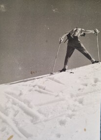
Frank May gained employment with the SEC on 1st July 1950 and was initially placed at Mount Beauty as a clerk. In September 1950 he transferred to a similar position at the Rocky Valley Dam construction site. He worked from October to April at Rocky Valley but then moved to Bogong Village as the construction site was closed during the winter. In October 1951 he returned to Rocky Valley but in November 1951 government funding cutbacks forced the SEC to he and many others from the Kiewa Hydro-Electricity Scheme were transferred or retrenched. Frank was transferred to the SEC in Colac where he worked as a meter reader. During his time at Falls Creek, Frank was a member of the Bogong Ski Club and enjoyed many adventures skiing on the High Plains.These images are significant as they depict an early SEC working skiing at Falls Creek.Two black and white images of Frank Mayfrank may, sec falls creek, bogong ski club -
 Kiewa Valley Historical Society
Saucer Ceramic, circa 1940's to 1950's
This item was used by the State Electricity Commission of Victoria in their mess rooms for their workers during the construction of the Kiewa Hydro Electricity Scheme. The imprint of the year "1921" was to identify the year that the SECV was formed and relieved the private VHEC (Victorian Hydro-Electric Company). As the scheme was of such a huge, isolated and time consuming nature the feeding of its workers was quite demanding of cutlery and crockery. The use of sturdy English cups and saucers was essential. The period of construction and the isolation of the Kiewa Valley area placed heavy demand for "solid" crockery that could wear abusive handling. This period in time was one when crockery, whether for domestic or commercial use, was imported from "mother" England. This scenario was more so for governmental bodies such as rail, jails and electricity providers than domestic users. The influx of cheaper Asian crockery had not yet begun.This type of crockery item was used by the thousands of SEC Victorian staff and construction workers involved in the building of the Kiewa Hydro Electricity Scheme, over the extensive period (1938 to 1961). This was a period when Government bodies and other semi- government organisations were still tied to the "establishments" of "mother" England. It was a period in Australia's development when the Asian influence was very weak and the established ties to England and Europe was still very strong. The majority of heavy equipment and machinery was either made in England or Europe. Local/European expertise in dam construction and water management in alpine terrain came from migrants or specially recruited English and Europe specialists. The quality of workmanship from big steel manufacturing plants in England and Europe could not be matched from anywhere else in the developed world.This item is a white ceramic State Electricity Commission Of Victoria saucer (tea /coffee). It is made in England and is of strong and durable ceramic. The bottom cup indent is for either tea or coffee cups of a similar ceramic structure. The 5mm thickness of the ceramic suggests this saucer belongs to a commercial kitchen environment and not domestic. The indent bottom of the saucer is 5mm deep with a side curvature ratio of 2:5. The ceramic is glazed to a commercial standard (worker's mess). See also KVHS 0128 (B to D)The seal of the State Electricity Commission Of Victoria is imprinted on the top inside rim within a curved scroll. Snuggled within the borders of the scroll is a banner with the five stars of the southern cross and an arm with a closed fist projecting from the top with five lightning bolts projecting outwards. On the underside "Vitrified sold by Cafe & Hotel Supplies Pty Ltd Dunn Bennett & Co. Ltd. Burslem Made in England"saucer, plate, secv, state electricity commission of victoria, crockery, mt beauty chalet, bogong mess hall -
 Kiewa Valley Historical Society
Plate Bread & Butter, Circa 1921
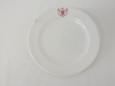
This item was used by the State Electricity Commission of Victoria in their mess rooms for their workers during the construction of the Kiewa Hydro Electricity Scheme. The imprint of the year "1921" was to identify the year that the SECV was formed and relieved the private VHEC (Victorian Hydro-Electric Company). As the scheme was of such a huge, isolated and time consuming nature the feeding of its workers was quite demanding of cutlery and crockery. The use of sturdy English cups and saucers was essential. The period of construction and the isolation of the Kiewa Valley area placed heavy demand for "solid" crockery that could wear abusive handling. This period in time was one when crockery, whether for domestic or commercial use, was imported from "mother" England. This scenario was more so for governmental bodies such as rail, jails and electricity providers than domestic users. The influx of cheaper Asian crockery had not yet begun.This type of crockery item was used by the thousands of SEC Victorian staff and construction workers involved in the building of the Kiewa Hydro Electricity Scheme, over the extensive period (1938 to 1961). This was a period when Government bodies and other semi- government organisations were still tide to the "establishments" of "mother" England. It was a period in Australia's development when the Asian influence was very weak and the established ties to England and Europe was still very strong. The majority of heavy equipment and machinery was either made in England or Europe. Local expertise in dam construction and water management in alpine terrain came from migrants for England and Europe. The quality of workmanship from big steel manufacturing plants in England and Europe could not be matched from anywhere else in the developed world.This item is a white ceramic plate (bread & butter). It is made in England and is of strong and durable ceramic. The bottom of the plate is flat with edges sloping out (to position the bread) and the extended rim is to catch any spillages. The 5mm thickness of the ceramic suggests this plate belongs to a commercial kitchen/eating establishment (mess) and not a domestic dining room. The indent bottom of the plate is 5mm deep with a side curvature ratio of 2:5. The ceramic is glazed to a commercial standard (see KVHS 0128 for its saucer part of a dinner set.The seal of the State Electricity Commission Of Victoria is imprinted on the top inside rim within a curved scroll. Snuggled within the borders of the scroll is a banner with the five stars of the southern cross and an arm with a closed fist projecting from the top with five lightning bolts projecting outwards. On the underside "Vitrified sold by Cafe & Hotel Supplies Pty Ltd Dunn Bennett & Co. Ltd. Burslem Made in England"saucer, plate, secv, state electricity commission of victoria, crockery -
 Bacchus Marsh & District Historical Society
Ceremonial object, Bacchus Marsh Hospital 1952 Gala Procession Trophy
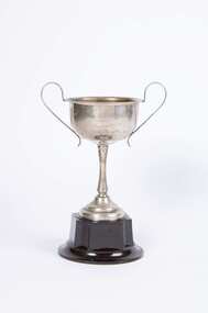
This cup, was awarded to participants in a Hospital Fundraising Gala Procession in 1952. The cup was just one of many prizes awarded to participants in a Gala Week of fund-raising activities for the construction of a hospital in Bacchus Marsh. Before 1957 there was no substantial hospital in Bacchus Marsh.. Two small private hospitals had operated in Bacchus Marsh up until the late 1940s. One of these, the 'Kelvin Grove' private hospital closed in 1948. This brought about efforts by the communities of Bacchus Marsh and Melton to raise funds for the building of a public hospital in Bacchus Marsh. Fundraising appeals and events for this purpose were conducted from the late 1940s onwards until enough money was finally raised for the construction of the Bacchus Marsh and District War Memorial Hospital which was officially opened on the 3 March 1957. Metal trophy cup with wide mouth and two handles that sit above the top of the cup. Cup is screwed to a brown bakelite plastic base. Bacchus Marsh Hospital Gala Procession 1952 Section 7 First Prizehospitals, bacchus marsh and district war memorial hospital -
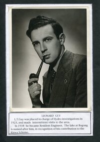 Kiewa Valley Historical Society
Photograph of Leonard Guy resident engineer for SECV
In 1940 Field Headquarters for the Kiewa Scheme were established at Bogong with office, workshop facilities and accommodation for workmen, staff and some families constructed. (There had been a 'tent camp' on this site in 1939 but was destroyed by bushfires) Construction of accommodation continued until 1947. Lake Guy was named after Mr. L.T. Guy Mr L.T. Guy was placed in charge of Hydro investigations in 1923 and became the resident engineer for the Kiewa Valley Hydro Scheme in 1938. He was the Resident Engineer in charge of construction work and associated activities on the Kiewa area. He held this position from 1939 to November 1946 when he was transferred to Head Office. Black and white photograph of Mr Leonard Guy. Photo mounted on black background with typed information regarding Mr Guy underneath, Printed in black ink, on white paper underneath photograph – LEONARD GUY L.T. Guy was placed in charge of Hydro Investigations in 1923 and made intermittent visits to the area. In 1938 he became Resident Engineer. The lake at Bogong is named after him in recognition of his contribution on the Kiewa Scheme. leonard guy, secv, bogong -
 Eltham District Historical Society Inc
Document - Series Listing, Fraser Faithfull et al, Series 57: Eltham Library Exhibition Space development, First Exhibition 1994, photographs, 2000
I) 22 colour photographs taken in the latter stages of construction of the new Eltham Library, illustrating the development of the exhibition area. This area required a special hanging system due to the mud brick walls of the library. 2) 18 colour photographs of exhibits on display at the first exhibition in the Eltham Library Community Gallery.shire of eltham archives, series listing -
 Eltham District Historical Society Inc
Document - Series Listing, Fraser Faithfull et al, Series 58: Eltham Library Exhibition Space development, First Exhibition 1994, negatives, 2000
I) 22 colour photographs taken in the latter stages of construction of the new Eltham Library, illustrating the development of the exhibition area. This area required a special hanging system due to the mud brick walls of the library. 2) 18 colour photographs of exhibits on display at the first exhibition in the Eltham Library Community Gallery.shire of eltham archives, series listing -
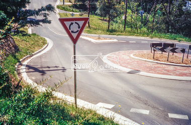 Eltham District Historical Society Inc
Photograph, Looking north along Ryans Road at intersection with Kerrie Crescent, Eltham, c.October 1989, 1989
Ryans Road was reconstructed and sealed to the north of Kerrie Crescent in 1983. Roundabout and southern reconstruction added later. This photo is probably shortly after construction of roundabout (before 1991 when Doug Orford photographed all the Shire boundaries as roundabout was well planted at that stage) Cross Ref: 04070 and 01878-25Roll of 35mm colour negative film, 1 stripsFuji 100eltham north, kerrie crescent, round about, ryans road, streets -
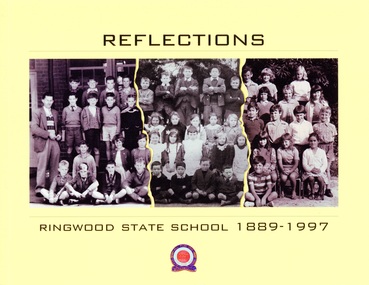 Ringwood and District Historical Society
Book, Reflections - Ringwood State School 1889-1997
This book was created for the centenary celebration of the Ringwood State School No. 2997, located on Greenwood Avenue, Ringwood, Victoria. Construction began on the new building in 1921. The building centenary celebration was held at that site, now Maroondah Federation Estate, on 12th November, 2022, a year later than expected due to the Covid epidemic.Collage of students' class photographs and Ringwood State School logo on front of yellow soft-cover book, containing multiple contributors' photographs and written memories.Acknowledgements: First and foremost, the people who provided personal stories are to be congratulated, having contributed intimate memories and photographs. This is their book. Contributors include: Russ Haines Thomas Guest Bill Adolphson Lindsay Adolphson Kerri Kirby (Mathieson) Glenda Oliver (Pottenger) Ian McCleave Dawn Rees (nee Riedel) Linda Cuthill Russ Read Marie Gribben Sir Ronald East Jennie Roe Coral Powell Liz Seaton Stan Mathieson Alan Rittman Denise (White) Wilson Ian Wilton Neville Burns Marion Tremlett (nee Hayward) Gavin Fry Lynette Broadway-Hill James Rogers Suzanne Strout (nee Rogers) Patricia Rogers Peter Fry Malcolm Hugh Powell -
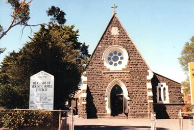 Hume City Civic Collection
Photograph, early 1990s
Our Lady of Mt. Carmel Church was designed by the architect William Wardell. Prior to the construction of the church, mass was conducted at the Daniel Home 'Narbonne'. The foundation stone was laid on 13/11/1804 by the Catholic Bishop of Melbourne, Rev. Dr. J. Goold and the church opened in 1875 with later additions erected in 1890.A coloured photograph of Our Lady of Mount Carmel Church. It is an image of the front on west end of the church which highlights the rose window above the door and shows the skillion roofed room on the south side of the church. On the LHS of the photograph there is a board giving details of the mass times and clergy.wardell, william, our lady of mount carmel church, catholic church, george evans collection -
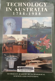 Kew Historical Society Inc
Book - Brown Gouge clothes brush, Australian Academy of Technological Sciences and Engineering, Technology in Australia, 1788-1988 : A condensed history of Australian technological innovation and adaptation during the first two hundred years, 1988
This book provides a history of technology in Australia from 1788 to 1988. There are twelve chapters by different authors. These chapters are: Innovation, science and the farmer (D.E. Tribe and L.J. Peel) Food technology (K.T.H. Farrer) Water and irrigation (K.D. Green) Forestry and forest products (W.H. Algar) Australian innovation in textile technology (D.S. Taylor) Engineering construction and building (J. Holland) Transport (B. Inglis) Communications and computers (J.H. Curtis and T. Pearcey) The chemical industry and Australian contributions to chemical technology (J.E. Kolm) The mineral industries (G.B. O'Malley) Energy (R.N. Morse) Manufacturing industry (P.N. Richards) Defence science and technology (J.L. Farrands and J.C. Wisdom) Index, photographs.Melbourne : Australian Academy of Technological Sciences and Engineering, c1988 xxix, 1017 p. : ill., maps, ports., plans, facsims. ; 26 cm. non-fictionThis book provides a history of technology in Australia from 1788 to 1988. There are twelve chapters by different authors. These chapters are: Innovation, science and the farmer (D.E. Tribe and L.J. Peel) Food technology (K.T.H. Farrer) Water and irrigation (K.D. Green) Forestry and forest products (W.H. Algar) Australian innovation in textile technology (D.S. Taylor) Engineering construction and building (J. Holland) Transport (B. Inglis) Communications and computers (J.H. Curtis and T. Pearcey) The chemical industry and Australian contributions to chemical technology (J.E. Kolm) The mineral industries (G.B. O'Malley) Energy (R.N. Morse) Manufacturing industry (P.N. Richards) Defence science and technology (J.L. Farrands and J.C. Wisdom) Index, photographs.technology -- australia -- history., technological innovations -- australia -- history. -
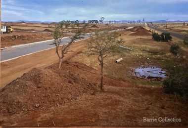 Melton City Libraries
Photograph, West Melton-Coburns Road, 1969
Coburns Road - 19th c family descendents living in Melton. Coburn Primary School Cr George Coburn. 1930’s. December 1935 Shire President Cr Geo Coburn convened meeting to form the Bush Fire Brigade. Road construction of Service road and beginnings of West Melton subdivision. West Melton-Early Division View of Coburns Road. council, local significant events -
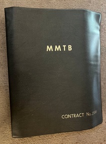 Melbourne Tram Museum
Legal record - Contract documentation - Z class, Melbourne & Metropolitan Tramways Board (MMTB), "MMTB Contract No. 2500", 1972 to 1974
Folder prepared by the MMTB Engineering and Stores department to document the tender, the formal tender response from Commonwealth Engineering and then the many letters or clarifications that would form the final contract document for construction of 100 Z class tramcars. See item 2266 for the Tender Schedule and item 7884 for the Comeng Proposal of 1972.Demonstrates the degree of the negotiation with Commonwealth Engineering and responses for the contract for the Z class tram.Plastic folder with three interscrews containing the contract documentation for the Z class tram. Includes a copy of the Tender Schedule for "100 All-Electric trams" in a back cover pocket. Has "MMTB Contract No. 2500" in gold block on the front. Folder by Arnold's plastics of Sydney."2011.016" in pencil on first sheet.tramways, mmtb, z class, tenders, new trams, comeng, commonwealth engineering, contracts -
 Melbourne Tram Museum
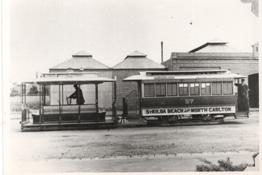
Photograph - Copy - Cable tram at Rathdowne St car house or depot, c1900
Copy photograph (based on the photo corners on the right-hand side) of a cable set outside the Rathdowne St or North Carlton line, car house. Trailer No. 57, lettered "St Kilda Beach and North Carlton" Has the grip man and conductor standing in their positions. The photo shows the construction of the car house.Yields information about the Rathdowne St car house and a cable set on the North Carlton line.Black and white copy photograph, plain back.tramways, cable trams, tram 57, north carlton, rathdowne st -
 Melbourne Tram Museum
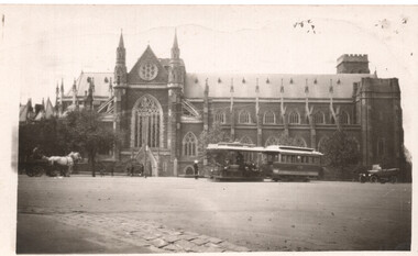
Photograph - St Patricks cathedral and cable tram, 1920s
Photograph shows a cable tram set in Gisborne St passing St Patricks Cathedral, during the 1920s. Possibly tram 121 There is a horse drawn cart on the left hand side. Photo during the 1920s prior to the construction of the cathedral spire. The Collins St line closed and was converted to electric trams in 1929.Yields information about St Patricks Cathedral and cable trams in Gisborne St.Black and white photograph with notes on the rear.On rear in pencil "Cable tram Melbourne.", Norm Boxhall stamp with number 56-32B and Ken Magor stamp No. 14 Has the number "55" in pencil in top right-hand corner. tramways, cable trams, st patrick's cathedral, tram 121 -
 Geoffrey Kaye Museum of Anaesthetic History
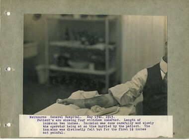
Album - Photograph album, Rupert Hornabrook
This photo album depicts a small period of time during 1919, and highlights some of the anaesthetic work conducted by Dr Rupert Hornabrook. There is no record as to the reason for the construction of the album, but it appears to offer insight into his work the Dental School, as well as experimentation with different types of anaesthetic agents, using himself as a test subject.Rupert Hornabrook was an early full-time anaesthetist in Australia. He helped to develop anaesthesia into a specialised field of medicine by conducting research into the way anaesthesia worked, and its effects on the body. This album is of historic significance as it not only documents a specific period in the professional life of a full-time anaesthetist in Australia, it also documents anaesthetic equipment, and the way it was used.Blue photograph album with vinyl wrapped heavy card cover. A three ringed binder is attached to the inside of the album and sixteen (16) photographs are inside, mounted on heavy card. Each photograph has a typed label on white paper in blue ink adhered to the front describing the events of the photograph. Photographs depict various administrations of ethyl chloride as anaesthesia and analgesia, with many photographs of Rupert Hornabrook.anaesthesia, anaesthesia history, medical history, dentistry, dental history, ethyl chloride, ether -
 Kiewa Valley Historical Society
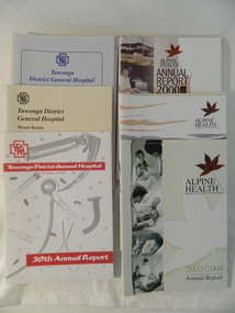
Reports - Annual Reports of Mt Beauty Hospital & Alpine Health, 1987 - 2004
The Tawonga & District Hospital was situated in Tawonga at the corner of Ryders Lane and the Kiewa Valley Highway. The construction was initiated by the Hospital & Charities Commission with considerable assistance from the SECV. It was officially opened in 1949. It was relocated to Mt Beauty in 1961. In 1997, the business combined with the hospitals in the Alpine Shire (Bright & Myrtleford) and became 'Alpine Health'.The annual reports of the local Mt Beauty hospital and associated health facilities gives an insight into its changes both medical and in its governance with its consequences to the small towns and district over the years.Booklets - Tawonga District General Hospital, Mt Beauty Annual Reports 1987 - 1996 and Booklets - Alpine Health - Bright, Mt Beauty Myrtleford Annual Reports 1997 - 2004tawonga & distrcit hospital, tawonga district general hospital, alpine health, mt beauty