Showing 23063 items
matching alpine-shire
-
 Eltham District Historical Society Inc
Photograph, Looking east near 51 Airlie Road, Montmorency, c.1989, 1989c
The Shire of Eltham was introducing a number of speed humps throughout the shire around this time period and took a photographic record of various new installations.Colour photographinfrastructure, airlie road, montmorency, speed humps, streets -
 Eltham District Historical Society Inc
Photograph, Looking west near 58 Airlie Road, Montmorency, c.1989, 1989c
The Shire of Eltham was introducing a number of speed humps throughout the shire around this time period and took a photographic record of various new installations.Colour photographinfrastructure, airlie road, montmorency, speed humps, streets -
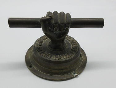 Hume City Civic Collection
Door Handle
This handle is believed to be from the first safe used by the Shire of Bulla. It was given to Mr. Kevin Smith by the Shire Secretary Mr. Tom McCormack.A heavy round base handle with a hand coming from the centre holding a rod that forms the handle.:Cozens & Harveys..."shire of bulla, smith, john, kevin, george evans collection -
 Glenelg Shire Council Cultural Collection
Certificate - Certificate - Syd Cuffe, Town Crier, c. 1996
Framed certificate, under glass, grey vellum, black script, floral border left and top, floral surrounded letter at beginning of each paragraph, black wooden frame, gold trim. Presented to Syd Cuffe at 1996 Australian National Town Criers' championships by the Moree Plains Shire -
Clunes Museum
Pamphlet - BROCHURE HEPBURN FEDERATION TRAIL, TERRY HOPE
HEPBURN FEDERATION TRAIL, BUILDING, COMMUNITIES, CREATING A NATION. A DRIVING TRAILTHOUGH THE SHORE, REVEALING STORIES ABOUT ITS PLACES, PEOPLE AND EVENTS. THE TRIAL EXPLORES THE CONNECTION BETWEEN THE NATURAL FEATURES OF THE SHIRE AND ITS SETTLEMENT SINCE TJE DJA DJA WRUNG PEOPLE FIRST MADE IT THEIR HOMEhepburn federation trail, dja dja wrung -
Whitehorse Historical Society Inc.
Map, Melbourne Metropolitan Area Base Map series. Sheet 214, c1960
Map showing northern section of the City of Nunawading together with parts of Shire of Doncaster and Templestowe.Map showing northern section of the City of Nunawading together with parts of Shire of Doncaster and Templestowe. Shows roads, creeks, block numbers and contours at 5 feet vertical increments. Note on map: 'prepared ... from State Aerial Survey, January 1957 and Cadastral Survey information February 1959'.Map showing northern section of the City of Nunawading together with parts of Shire of Doncaster and Templestowe. maps, city of nunawading, shire of doncaster and templestowe -
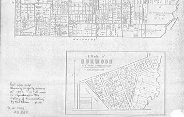 Whitehorse Historical Society Inc.
document - Map, Village of Burwood, 1892
Map on the village of Burwood.Village of Burwood : old name Ballyshanassy (with southern section of Nunawading). Area bounded by Chapman, Ireland and Evans Streets). Victorian Shire Map. co. 26 November 1892. Scale: 8 chains = 1 inch. The full map is reproduced in 'The History of Nunawading' by Niall Brennan, p. 62.Map on the village of Burwood.burwood, land settlement -
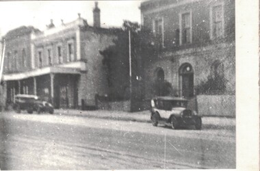 Linton and District Historical Society Inc
Photograph, Sussex Street, Linton, circa 1920
Somewhat blurry black and white copy of an original photograph which has been mounted on white card. View to the west of Sussex Street, Linton, showing the Grenville Shire Hall, Criterion House and Shepherd's store. The two cars shown parked in the street suggest the photograph was taken in the 1920s.shire hall linton, shire of grenville offices and hall, criterion house, shepherd's store, sussex street linton, buildings -
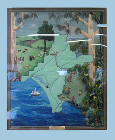 South Gippsland Shire Council
Quilt, Woorayl in Threads, 1988
Framed quilt depicting Woorayl Shire boundries. Features animals, sea, boat and birds. Embroidered and sewn in fabric, wool and thread. Engraved brass plaque affixed to lower edge. Brown textured wood frame, perspex case covering entire work. Sitting on purpose built ledge. -
Clunes Museum
Map, 1962
.1 &.2 MAP OF BALLARAT SHIRE GROUP RURAL FIRE BRIGADES FIRE CONTROL MAP. COMPILED BY C. H. FENTON. (2 COPIES) DETAILING SEALED ROADS, STATE FORESTS, PINE PLANTATIONS, FOREST AREAS, RAILWAYS, BOUNDARIES, TOWNSHIP AREAS CEMETERIES, CREEKS, SWAMPS AND HOUSES.local history, document, maps, fire brigade -
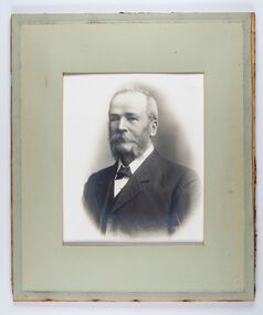 City of Greater Bendigo - Civic Collection
Photograph - Portrait of Councillor Long, Talma & Co
The district of Strathfieldsaye was proclaimed in 1861 and named a Shire on the 17th September in 1866. It remained a shire until amalgamation in 1994 when it became part of the City of Greater Bendigo. The shire was located 8 km to the south- east of Bendigo and covered an area of 601 square kilometres and extended from the Calder Highway to the Coliban and Campaspe Rivers. The shire's administration centre was in Strathfieldsaye until 1972 when new offices were opened in Kennington.Framed black and white head and shoulder portrait of Councillor Long. Profile to left with walrus moustache and mutton chops. Cut olive retangle mount. Verso; Long. On under board which has photograph attached; Talma & Co. / 119 Swanston St., / Melbournestrathfieldsaye shire council, councillor long -
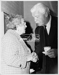 Eltham District Historical Society Inc
Photograph, His Excellency Sir Rohan Delacombe with a member during his visit to Lower Plenty Elderly Citizens' Club, 19 September 1973
The State Governor Sir Rohan Delacombe and Lady Delacombe visited the Shire of Eltham where they were entertained to a civic luncheon by the Shire President Cr. L. E. Clarke and councilors at the Panton Hill hotel and made a tour of the shire, including the Lower Plenty Elderly Citizens Centre.This photo forms part of a collection of photographs gathered by the Shire of Eltham for their centenary project book, "Pioneers and Painters: 100 years of the Shire of Eltham" by Alan Marshall (1971). The collection of over 500 images is held in partnership between Eltham District Historical Society and Yarra Plenty Regional Library (Eltham Library) and is now formally known as 'The Shire of Eltham Pioneers Photograph Collection.' It is significant in being the first community sourced collection representing the places and people of the Shire's first one hundred years.Digital imagesepp, shire of eltham pioneers photograph collection, eltham, governor of victoria, sir rohan delacombe, lower plenty elderly citizens' club, seniors, older women -
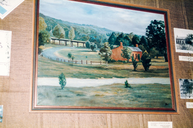 Eltham District Historical Society Inc
Photograph, Peter Bassett-Smith, Beautiful Eltham, Joh Ebeli, 1988
Former Shire of Eltham Art Collection now Nillumbik Shire Council Art Collection, 'Beautiful Eltham' by Joh Ebeli showing Shillinglaw Cottage and Railway Trestle Bridge. Bicentennial/Heritage Week Display, "The Eltham Tradition", Eltham Shire Office, 17-22 April 1988 Colour photographactivities, eltham shire office, heritage display, heritage week, beautiful eltham, joh ebeli, shillinglaw cottage, trestle bridge -
 City of Moorabbin Historical Society (Operating the Box Cottage Museum)
Newsletter, City of Moorabbin Historical Society Aug 2008, August 2008
The City of Moorabbin Historical Society was formed c 1960 by a group of Moorabbin residents who were concerned that the history of the area should be preserved. A good response to a call for items related to the historical area of Moorabbin Shire brought donations of a wide variety of artefacts which are now preserved by the current members of CMHS at Box Cottage Museum . Helen Stanley, Secretary of CMHS, began producing a Newsletter for members in April 2007 to provide current information and well researched items of historical interest. Helen Stanley has produced a bi-monthly Newsletter, 2007 - 2013, for the members of the City of Moorabbin Historical Society that contains well researched interesting historical items, notification of upcoming events, current advice from Royal Australian Historical Society , Museums Australia Victoria and activities of Local Historical Societies. The Newsletter is an important record of the activities of the CMHS. The Blackman family were early settlers in Moorabbin Shire A4 paper printed both sides x1. Issue 8 of the bi-monthly, City of Moorabbin Historical Society Newsletter produced by Society member and Secretary, Mrs Helen Stanley in August 2008. Notices of a talk by Dorothy Booth, “ The Historic Mentone Railway Gardens’ on August 31st and a request for volunteers to begin an Inventory of the Box Cottage artefacts and to assist at upcoming Open Days. An excerpt from the CMHS Newsletter March 1965 ‘ Three Pieces of Paper’, by Mrs Nance Blackman, a member, describing items from “The Moorabbin News” ‘ 1907 that included The Cheltenham Butter Factory, and advertisements aimed at the local people and their occupations. Note is made of 3 businesses run by Women – butcher, milk delivery and a ‘delicatessen’ - and an ‘Oriental Laundry’ in Cheltenham, as well as the trading hours for shops and weekly wages. Gas light and candles were in common use because Electricity did not come to Bentleigh until 1916 and several Fire Brigades were formed in the Shire. A photocopied photograph of an Electric Power pole c1930.CITY of MOORABBIN HISTORICAL SOCIETY / AUGUST 2008 NEWSLETTER city of moorabbin historical society, stanley helen, melbourne, moorabbin, mentone, mordialloc, cheltenham, ormond, bentleigh, market gardeners, farmers, dairymen, confectioner, pioneers, early settlers, moorabbin shire, blackman nance, box cottage museum, highett, booth dorothy, mentone railway station gardens, cheltenham butter factory, beazley hannah, redstron mrs., bickerton mrs., oriental laundry cheltenham, biehl mr., matthews mr., gas-light, electric light, smith j.l., journeaux james, king george, grommann’s hotel mordialloc, telephones, fire brigades -
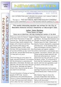
 Greensborough Historical Society
Magazine - Article, Judy Lewis, Eltham welcomes back the Civic Centre, by Judy Lewis, 2008
Article on proposal to move the Nillumbik Shire Council Offices to the site of the old Shire of Eltham offices on Main Road Eltham, adjacent to the Eltham Library2 p., text, black and white and colour photographs. Extract from Eltham Town Community News, Issue 5, Summer 2007-08nillumbik council, eltham, main road eltham -
Tatura Irrigation & Wartime Camps Museum
Book, The Way We Were, 1995
Timeline from 1841-1994, when squatters first settled at Tongala. Includes stories of families from Deakin Shire, now Shire of Campaspe.Cream cover, brown writing, 13 sepia like sketches of early buildings, transport, irrigation, farming, settlers, harvesting.tongala, deakin shire, shire of campaspe -
 Warrnambool and District Historical Society Inc.
Book, Victorian Institute of Surveyors Transactions and Proceedings 1919, 1919
This book belonged to John William Crawley, Junior, a member of the Victorian Institute of Surveyors. He was an engineer, architect and surveyor in private practice in Warrnambool and also the engineer for the Shire of Warrnambool from 1895 to 1935. His father, brother and son were also engineers and worked in that capacity or as the Shire Secretary for the Shire of Warrnambool, with the Crawley family members recording a total of 132 years of service to the Shire of Warrnambool which existed from 1863 to 1994. This book is retained as it belonged to John Crawley, the engineer for the Shire of Warrnambool for 40 years. This is a hard cover book with a dark brown cover with gold lettering on the spine. The cover is stained and worn away in places. The book contains 14 articles, reports of the Council for the years 1909 to 1919 and office-bearers for 1919-20. There are several black and white photographs and fold-out maps and plans. The signature on the first page is handwritten in black ink.J Wm Crawley 9/9/19crawley family, warrnambool, shire of warrnambool, history of warrnambool -
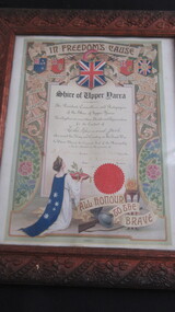 Lilydale RSL Sub Branch
Certificate, "In Freedoms Cause"
Framed Certificate for Leslie Raymond JackShire of Upper Yarra/ The President, Councilors and Ratepayers of the Shire of Upper Yarra hereby place on record their thanks and appreciation for the conduct of Leslie Raymond Jack who served his King and Country in The Great War/ In Witness whereof the Corporate Seal of the Municipality is hereto attached in the presence of / A J Speers President, Henry E Glynn, Councillor. H B Wornerslie, Secretary. Dated 24/5/1918. / All Honour to the Brave. -
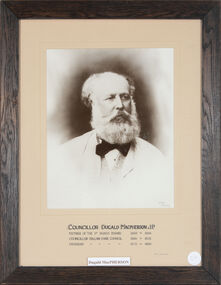 Ballan Shire Historical Society
Photograph - Macpherson, Dugald J.P, Framed portrait of Councillor Dugald Macpherson J.P
Sepia photograph, mounted on fawn cardboard in a very dark timber frameCouncillor Dugald Macpherson J.P. Member of the Road Board 1862 - 1864 Councillor Ballan Shire Council 1864 -1873 President 1875 - 1880 Colart - Melbourne Merv Quinn 1992ballan shire councillor, •ballan shire president, •ballan road board, macpherson dugald -
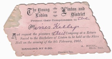 Linton and District Historical Society Inc
Card - Invitation, The Young Ladies of Linton and District, 1901, 1901
Small, pale pink polygon-shaped invitation card with decorative black printing. Name of invitees handwritten in ink. The dance would have been a way for young singles of the area to meet and socialise with members of the opposite sex.Text: The Young / Ladies OF Linton and / District / Present their Compliments to the / Misses Kellys / And request the pleasure of their Company at a Return / Social to the Bachelors of Linton to be held at the Shire / Hall on the evening of the 8th February, 1901.linton shire hall, dances, social gatherings -
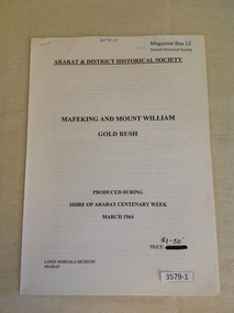 Stawell Historical Society Inc
Book, Ararat & District Historical Society, Mafeking and Mount William Gold Rush, 1964
Gold mining in the Mafeking and Mount Willaim AreasWhite Paper cover with Printed title and other information. Staple in top left cornerArarat & District Historical Society Mafeking And Mount William Gold Rush Produced During Shire of Ararat Centenary Week March 1964 Price $1.50 Langi Morgala Museum Araratstawell mining -
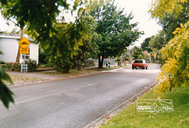
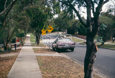
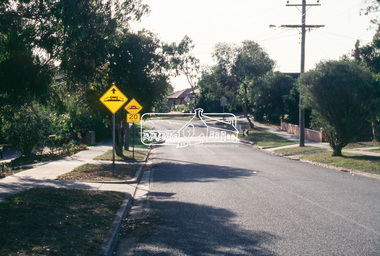 Eltham District Historical Society Inc
Slide - Photograph, Airlie Road, Montmorency, c.Apr. 1988
The Shire of Eltham was introducing a number of traffic calming measures throughout the shire such as speed humps, roundabouts, chicanes and took a photographic record of various new installations.35mm colour positive transparency (4 of 11) Mount - whiteProcess Date "Apr M"airlie road, infrastructure, montmorency, roads, speedhumps -
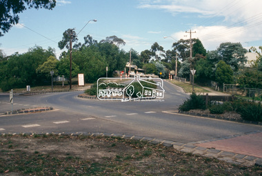 Eltham District Historical Society Inc
Slide - Photograph, Kangaroo Ground-St Andrews Road, Panton Hill, c.Apr. 1988
The Shire of Eltham was introducing a number of traffic calming measures throughout the shire such as speed humps, roundabouts, chicanes and took a photographic record of various new installations.35mm colour positive transparency (4 of 11) Mount - whiteProcess Date "Apr M"infrastructure, roads, bishops road, panton hill, roundabout, merritts road, kangaroo ground-st andrews road -
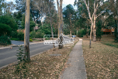 Eltham District Historical Society Inc
Slide - Photograph, Dunstan Drive, Hurstbridge, c.Apr. 1988
The Shire of Eltham was introducing a number of traffic calming measures throughout the shire such as speed humps, roundabouts, chicanes and took a photographic record of various new installations.35mm colour positive transparency (1 of 11) Mount - whiteProcess Date "Apr M"infrastructure, roads, chicane, dunstan drive, hurstbridge -
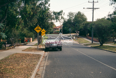 Eltham District Historical Society Inc
Slide - Photograph, Airlie Road, Montmorency, c.Apr. 1988
The Shire of Eltham was introducing a number of traffic calming measures throughout the shire such as speed humps, roundabouts, chicanes and took a photographic record of various new installations.35mm colour positive transparency (1 of 11) Mount - whiteProcess Date "Apr M"infrastructure, roads, airlie road, montmorency, speedhumps -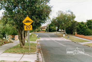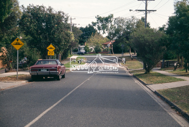
 Eltham District Historical Society Inc
Slide - Photograph, Airlie Road, Montmorency, c.Apr. 1988
The Shire of Eltham was introducing a number of traffic calming measures throughout the shire such as speed humps, roundabouts, chicanes and took a photographic record of various new installations.35mm colour positive transparency (2 of 11) Mount - whiteProcess Date "Apr M"infrastructure, roads, airlie road, montmorency, speedhumps -
 Bacchus Marsh & District Historical Society
Map, Bacchus Marsh Township and Nearby Districts Maps Volume
This volume of maps is believed to have been compiled by staff at the Shire of Bacchus Marsh and was presumably used to inform and assist Shire staff and Councillors in the carriage of their duties.This collection of maps are significant due to their rarity as many of them are unique maps made for local purposes in the Bacchus Marsh region. They are also of strong research value containing a wide variety of information including landholders, land sales, infrastructure, such as roads, bridges, public, commercial and private buildings, houses, land use, and geographic features over multiple decades from the late nineteen century into the middle part of the twentieth century.One bound volume of maps comprising cadastral maps, (indicating property owners and land boundaries), land plans and real estate auction plans and advertising material, and other maps indicating major infrastructure like proposed roads and irrigation areas. Most of the maps and plans are of Bacchus Marsh and nearby areas but some maps are of nearby towns such as Melton, Ballan and Blackwood. The volume comprises 52 pages. Most pages have a single map or plan pasted onto it but some contain 2 or 3 different maps. There are 81 maps in total. Map 1 Liquidators Sale 1896. Map 2. Woodside Estate Sale 1913. maps, maps bacchus marsh, maps bacchus marsh region -
Glenelg Shire Council Cultural Collection
Photograph - Collection of four photographs - K.S. Anderson and Port of Portland Authorities, n.d
a. black and white passport sized photograph of K.S. Anderson b. black and white photo of K.S. Anderson and his brother Bruce Learmonth Anderson c. Coloured photo of Mr. and Mrs. Edgar, K.S. Anderson, Ralston Thomson d. coloured photo of Brownie and Betty outside shire officesk s anderson, portrait photography, port of portland -
Glenelg Shire Council Cultural Collection
Award - Award - Trophy For Best Kept Private Garden Glenelg Shire, c. 2000
MDF trophy, with green marbelled finish. Metal plaque attached - green and gold fancy edges, the rest black with green. Small brass plaques with winners names engraved. 'Best kept private garden in the Glenelg Shire' - engraved top; donated by Pot a around Nursery Heywood' - engraved bottom.