Showing 27535 items
matching yarra-river
-
 Federation University Historical Collection
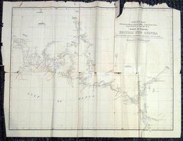
Map, British New Guinea, 1893, 1893
The map was surveyed by ship compass, distances by estimation or rate of launch by officers of the Government ; supervised and compiled by J.B. Cameron, G.S. March 1893. This map was in the possession of Charles Carty Salmon (1860-1917), politician, born on 27 July 1860 at Amherst, Victoria. (http://adb.anu.edu.au/biography/salmon-charles-carty-8328 ) Although living in Melbourne Charles Carty Salmon kept property at Talbot. The property was leased, then purchased by the donor's family. A copy of "The Goulburn Weir and its Dependent System of Works" and this map (in a government envelope addressed to Salmon) were left at the property. See http://nla.gov.au/nla.map-rm1894-1 .1) Sketch map showing the rivers and an outline of the coast from Long. 144?30'E. to Long. 146?30'E. Gulf of Papua British New Guinea Scale [ca. 1:316,800]. .2) Large envelope addressed to The Hon Charles Carty Salmon M.P., Talbot, Victoria. The map was folded and stored in this envelope. Map extending from Port Bevan to Kaikavau Pt, showing rivers and notes on soil and vegetation. Relief shown by hachures and spot heights. Also available in an electronic version via the Internet at: http://nla.gov.au/nla.map-rm1894-1 .1) "Enclosure in Despatch No. 32 of 3rd May 1893 - Appendix G.". "Map no. 4 British New Guinea report 1892-93". .2) "This envelope can only be lawfully used by Government Officials on public business. Any use by Officials on private business, or by others under any circumstances, is punishable." "Commonwealth Celebrations. General Secretary's Office, Melbourne."carty salmon, charles carty salmon, new guinea, j.b. cameron -
 Lilydale RSL Sub Branch
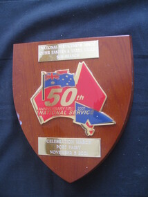
Plaque, 50th Anniversary 1951-2001 National Service
Brass-plate above reads "National Servicemen's Association Outer Eastern and Yarra Valley sub-branch" - Stylized map of Australia with Australian flag at top left flowed by the words 50th/Anniversary 1951-2001/National Service/ Below brass plate reads/ "Celebration March/Port Fairy/November 3 2001 -
 Melbourne Tram Museum
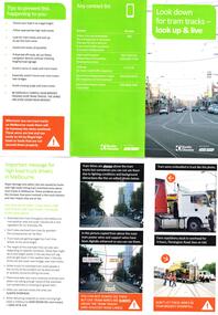
Pamphlet, Keolis Downer, "Look down for tram tracks - look up & live", Feb. 2019
Pamphlet - 3 fold DL full colour, titled "Look down for tram tracks - look up & live", prepared for truck drivers driving high vehicles, has images of tram wires and incidents. Published by Yarra Trams and Keolis Downer. Has contact numbers. Published Feb. 19. Two copies held.trams, tramways, yarra trams, overhead, road transport, keolis downer -
 Melbourne Tram Museum
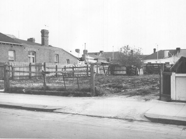
Photograph - Set of 12 Black & White Photograph/s, Melbourne & Metropolitan Tramways Board (MMTB), 1966
Series of 12 black and white photographs of the construction of a new substation, during 1966 at the corner of Greville St and Punt Road, South Yarra. Shows the vacant block, construction of the foundations, walls and a part of the roof. In the box was a slip of paper marked - "To Architect 6.6.66" See item 7269 for three colour photographs of the completed building.On the rear of some of the photos are dates eg 30/5 on .1 trams, tramways, substation, electrical equipment, electrical switching, buildings -
 Melbourne Tram Museum
Pamphlet, VicRoads, "Tram route 59 transport improvement project", Oct. 2011
Pamphlet - 3 fold DL - titled "Tram route 59 transport improvement project", Early information update 1, detailing with a plan changes to Mount Alexander Road, Flemington and Travencore, Oct. 2011. Gives details of the staging, roadworks and timing. Has the Yarra Trams, VicRoads, Think Tram and Victorian Government logos.trams, tramways, mount alexander road, route 59, trackwork, road works -
 Melbourne Tram Museum
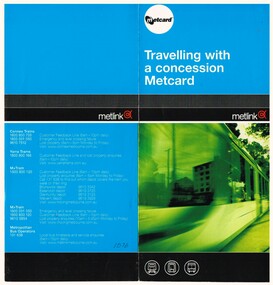
Pamphlet, Metlink, "Travelling with a concession Metcard", early 2000's
Pamphlet - DL size, two fold full colour printed on gloss paper titled "Travelling with a concession Metcard", what type of cards are valid to obtain a concession fare - Pensioner concession, health care cards, seniors and student cards. Has contact details on the rear for Connex, Yarra, M>Tram and M>Train.trams, tramways, metcard, metlink, m>tram, concession fares -
 Orbost & District Historical Society
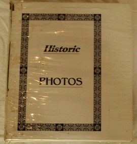
book, Historic Photos, c 1986
This book was compiled by volunteers at the Orbost Visitor Information Centre(Slab Hut) as a reference for visitors.This item is a useful reference tool.A white plastic-covered 2 ring binder with title Historic Photos inside cover. It contains photos of past and present residents , businesses, streets, transport, scenery, bridges and nearby places. It also contains a newspaper - Snowy River Holiday News (1986).orbost-history slab-hut -
 Orbost & District Historical Society
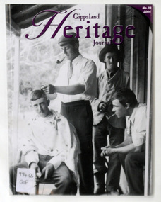
journal, Gippsland Heritage Journal, 2004
This issue edited by Meredith Fletcher.This item is a useful reference for the history of Gippsland.A 64 pp magazine, plastic covered, titled Gippsland Heritage Journal. The front cover is purple with a b/w photograph of the Hamilton Brothers on the verandah of Ensay Station. The magazine contains photographs, articles on the history of Gippsland. It includes a story on "The Snowy River Bandit".On back is a library barcode and a price sticker-$13.20. On the front cover is a call no. 996.65 GIPmagazine-gippsland-heritage-journal history-gippsland snowy-river-bandit -
 Kiewa Valley Historical Society
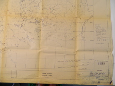
Plan - Kiewa Scheme General Plan 1958, S.E.C.V. Design & Construction Dept. Civil Branch, Dec. 1958
The Kiewa Hydro Electric Scheme was constructed by the State Electricity Commission of Victoria. Draftsmen drew up the plan of the layout as per the instructions from the engineers. The plan was drawn up on a transparency sheet and paper prints run off on a 'dyeline' copier. The 'Chief draftsman' and 'Design engineer' and 'Civil engineers recommended it and approved it. Historic: This plan gives a time line for the work on the Kiewa Hydro Electric Scheme. It is a good example of the work of a draftsman and the copying process in 1958.Large topography map of the area covered by the Kiewa Hydro Electric Scheme in 1958. Mountain peaks are marked in red and named. Rivers, roads, construction infrastructure as well as the main areas / names of construction are named. Signed and dated by employees of the S.E.C.V. working on the scheme.state electricity commission of victoria., kiewa hydro electric scheme, plan, engineer, draftsman -
 Marysville & District Historical Society
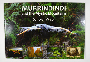
Book, Donovan Wilson, Murrindindi and the Mystic Mountains, Post 2009
A book of photographs of natural attractions, flora and fauna taken in and around the Murrindindi Shire.Paperback. Front cover has a large photograph of a lyrebird in full song. Along the lower edge of the front cover are four photographs; a Spotted March frog, the Gould Memorial Drive, a river and a wombat. Back cover has a photograph of the Cathedral Range at dawn.non-fictionA book of photographs of natural attractions, flora and fauna taken in and around the Murrindindi Shire.murrindindi, victoria, landmarks, flora, fauna, waterfalls, rivers, nature, natural attractions -
 Bendigo Military Museum
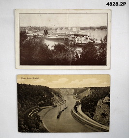
Postcard - POSTCARD, PHOTOGRAPHIC, WW1, League of Soldiers Friends, Victoria
1. This card was printed by the "League of soldiers friends - C of E Organisation in Victoria. To help the A.I.F." It has been stamped by the AIF camp PO 19 April 19. 2. Nothing specific.1. Black and white view of ships in a harbour. In the foreground are some tree tops. A big city is in the background. This card has a pre-printed message from Southhampton. 2, Boats in a river/canal. Black and white photo. The water way is in a deep valley.1. Addressed to Miss S. Stuart, Serpentine via Inglewood, Vic, Australia. It is signed by J. Stuart. 18 April 1919. 2. Addressed to Dear Susie, 10 lines text - signed your loving brother Joe.postcards, ww1 -
 Glenelg Shire Council Cultural Collection
Print - Contact Print - Wattle Creek Pastoral Scene, 1960-1979
Sheet of 2 black and white contact prints from glass plate negatives. Top: River/Creek ? Wattle Creek running thru reeds and bushland. Bottom: Bridge across Wattle Creek from beach. Botanic Gardens on right, Kingsley in background. -
 Kiewa Valley Historical Society
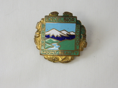
Badge Brass - Mt Beauty High School, circa 1970
Schools of this era were very proud of their identity. This was particularly so in country based ones. Schools in isolated or semi isolated regions provided social cohesion and pride and community involvement that was not so inherent in schools located in larger cities. The exception here being the Greater Public Schools. This badge was worn by a local girl, who has the spirit shown by many pupils from the Mount Beauty High School that the identity of belonging to a Kiewa Valley High School is a treasured part of life for them in this regional area. Mount Beauty High School badge made of brass. The front is coloured enamel depicting a scene of sky, mountains, grass and river. It is surrounded on four sides by the words Excelsior, Mount Beauty, High, School. The outside edges are decorated with gold colored fernsExcelsior, School, Mount Beauty, High On flip side K. G. Luke Melb.school badge, hat, lapel badge, high school memorabilia, brass badge -
 Orbost & District Historical Society
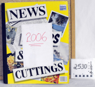
scrap books, 2006 ; 2007
These four scrap books were compiled by Margaret Smith, a long time member of the Orbost & District Historical Society. They were donated by her family after her death in 2015.These items are useful reference tools.Four large scrap books containing clippings from the Snowy River Mail. They are pasted in. Two books, 2529.1 and 2529.2 are for 2007 and 25209.3 and 2529.4 are for 2007. All books are large format books for NEWS & CUTTINGS. they contain personal items and news articles.Labelled 2006 and 2007smith-margaret news-orbost scrap-books -
 Marysville & District Historical Society
Book, Donovan Wilson, Murrindindi and the Mystic Mountains, Post 2009
A book of photographs of natural attractions, flora and fauna taken in and around the Murrindindi Shire.Paperback. Front cover has a large photograph of a lyrebird in full song. Along the lower edge of the front cover are four photographs; a Spotted March frog, the Gould Memorial Drive, a river and a wombat. Back cover has a photograph of the Cathedral Range at dawn.non-fictionA book of photographs of natural attractions, flora and fauna taken in and around the Murrindindi Shire.murrindindi, victoria, landmarks, flora, fauna, waterfalls, rivers, nature, natural attractions -
 Bendigo Historical Society Inc.
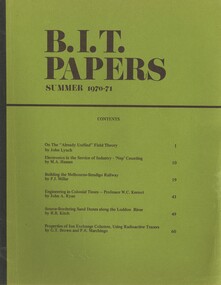
Book - BIT PAPERS, 1971
B.I.T. Papers Summer 1970-71, articles by various contributors, contents include, Building the Melbourne-Bendigo Railway, Engineering in Colonial Times, Source-Bordering Sand Dunes along the Loddon River & others, 66 pages with black and white photographs and maps..history, australian -
Bendigo Historical Society Inc.
Map - CAMPBELL COLLECTION: BENDIGO AND DISTRICT MAPS, 1929
Map. Campaspe, Parish of Kimbolton. Total area 4117 acres. Campaspe River, Kimbolton. Scale 20 chains to 1 inch. Prepared in W.P.B. form Parish and Assessment Plans. G.W.L. 9-4-29. (number 351 in map cupboard 1)map, bendigo, allotments -
Bendigo Historical Society Inc.
Map - DERBY : COUNTY OF BENDIGO, 1959
Map. Derby, County of Bendigo, Bridgewater, Inglewood, Tarnagulla, Woodstock, Leichardt, Loddon River. By authority A.C. Brooks, Government Printer, Melbourne. Drawn and reproduced at the Department of Lands and Survey, Melbourne. 1959. Price 2/-. (number 54 in map cupboard 1)A.C. Brooks, Government Printer, Melbourne.map, bendigo, derby -
 Coal Creek Community Park & Museum
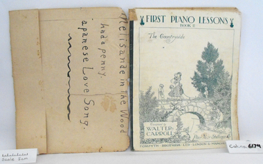
Music Book, First Piano Lessons, Book II, The Countryside
Music book "First Piano Lessons, Book II, The Countryside", Composed by Walter Carroll, covered in brown discoloured paper, original cover has a white background with charming illustration of children walking over stone bridge and fishing in the river, printed in blue.. -
 National Vietnam Veterans Museum (NVVM)
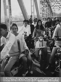
Photograph, Gibbons. Denis, Hue Traffic Jam
A black and white and a coloured photograph of Hue, South vietnam, Circa 7th Dec 1968. A traffic jam of Vietnamese motor bikes, cars and pedestrians is stopped on the bridge over the Perfume River at Hue leading to the city. The local population was on its way to work.photograph, hue, gibbons collection catalogue -
Clunes Museum
Document - CENTRAL HIGHLAND REGION WATER
.1 SEWERAGE AND SANITATION - STATISTICAL SUMMERY 30 JUNE 1948 .2 TOWNS WATER SUPPLY. SUPPLIED BY THE STATE RIVERS & WATER SUPPLY COMMISSION - PORTION OF COLIBAN SYSTEM .3 TOWNS WATER SUPPLY DISTRICTS AND WATERWORKS TRUSTS 30 JUNE 1948central highland region, central highland water, state river & water supply commission -
 Anglesea and District Historical Society
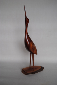
Carved Wooden Bird, Estimated 1990s
Wooden carving of a wading bird made from Australian cedar grown and collected in the Richmond River area of New South Wales. Base made from Bul-oak grown and collected in the Ballan area Vicoria. Makers card, attached, shows No. 974.australian cedar, bul-oak -
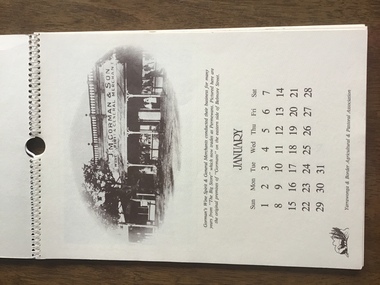 Yarrawonga and Mulwala Pioneer Museum
Calendar 1984, Yarrawonga over the Years, 1983
“Spiral bound A4 size 12 pages and front and back cover. Cream embossed heavy paper with sepia print. Contains one page for each month. Depicts early scenes of Yarrawonga Streets, river, hotels, stores, Showgrounds - all with descriptions See photos -
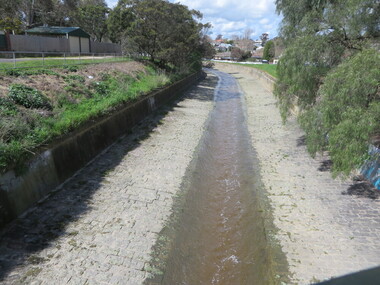 Ballarat Heritage Services
Photograph - Photograph - Colour, Clare Gervasoni, Yarrowee Creek after days of heavy rain, 2016, 17/09/2016
A number of photographs of the Yarrowee River after days of heavy rain. Two and three day previously the water reached the edges of the channel and was flowing very fast. The photographs were taken from and around the Hill Street Bridge near the Sunnyside Woollen Mills.yarrowee creek, yarrowee river, bridge, chanel, hill street, ballarat east -
Lakes Entrance Regional Historical Society (operating as Lakes Entrance History Centre & Museum)
Photograph, Lakes Post Newspaper, 1999
Colour photograph of members of Tambo Nicholson River Management Group seated at round table discussion Charles Hogan Alan Somerville Margaret Gardener Jeanette Severs Rex Candy Kevin Dean Robin Minter and Bill Wilson East Gippsland Victoriaenvironment, fish, waterways -
Lakes Entrance Regional Historical Society (operating as Lakes Entrance History Centre & Museum)
Photograph, Caire, Nicholas John, 1905c
Latrobe Bridge Sale Victoria in closed position . The operating machinery is still visibleBlack and white photograph of the Latrobe Bridge, in its closed position. The operating machinery is visible, plus the unique pier structure of the central span. In the rowing boat moored along side the river bank, a person wearing a boater hat is seated. Sale Victoriawaterways, bridges, civil engineering -
 Bendigo Historical Society Inc.
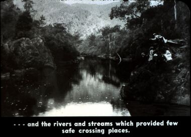
Slide - DIGGERS & MINING. DIGGERS AND MINERS, c1800s
Diggers & Mining. Diggers and miners. Walhalla - Gold Town. - - - and rivers and streams which provided few safe crossing places. Three women and one man on the right bank which is very steep. Markings: 17 995 WAL. Used as a teaching aid.hanimounteducation, tertiary, goldfields -
 Bendigo Historical Society Inc.
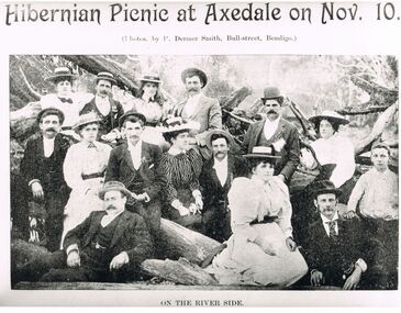
Photograph - PETER ELLIS COLLECTION: HIBERNIAN PICNIC AT AXEDALE
Black and white photograph. 'Hibernian Picnic at Axedale on Nov. 10'. (photos. By P Dermer Smith, Bull-street, Bendigo.) On the River Side. Men and women sitting in and on fallen tree branches. Ladies in hats and long dresses. Men wearing suits and hats.P Dermer Smith, Bull-street, Bendigophoto, group, mixed group -
 Wodonga & District Historical Society Inc
Album - Hume Reservoir Australia Album - Foundation work and dam construction, June 1924, 1927
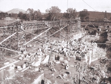
This set of photos is from a leather bound album bearing the inscription "HUME RESERVOIR AUSTRALIA" plus 'The Rt. Hon. L. C. M. S. Amery, P. C., M .P.' all inscribed in gold. It was presented to The Rt. Hon. L. C. M. S. Amery, P. C., M. P, Secretary of State for Dominion Affairs on the occasion of his visit to the Hume Reservoir on 2nd November 1927. This album is of local and national significance as it documents the planning and development of the Hume Reservoir up to 1927. It was the largest water reservoir in the British Empire. The album records the pioneering engineering work that went into its construction.DEPARTMENT OF PUBLIC WORKS, N.S.W. RIVER MURRAY WATERS SCHEME. HUME RESERVOIR. 13. Foundation work and dam construction proceeding inside levee bank which may be seen at the right hand end of the work, New South Wales, June 1924.hume reservoir australia, river murray waters scheme, hume reservoir construction -
 Wodonga & District Historical Society Inc
Album - Hume Reservoir Australia Album - Gravity incline for transport of rocks, 1927
This set of photos is from a leather bound album bearing the inscription "HUME RESERVOIR AUSTRALIA" plus 'The Rt. Hon. L. C. M. S. Amery, P. C., M .P.' all inscribed in gold. It was presented to The Rt. Hon. L. C. M. S. Amery, P. C., M. P, Secretary of State for Dominion Affairs on the occasion of his visit to the Hume Reservoir on 2nd November 1927. This album is of local and national significance as it documents the planning and development of the Hume Reservoir up to 1927. It was the largest water reservoir in the British Empire. The album records the pioneering engineering work that went into its construction.DEPARTMENT OF PUBLIC WORKS, N.S.W. RIVER MURRAY WATERS SCHEME. HUME RESERVOIR. 16. Gravity incline for transport of "plums" from Quarry, New South Wales. "Plums" were larger rocks which could be re-used for other construction purposes.hume reservoir australia, river murray waters scheme, hume reservoir construction