Showing 7103 items matching "snowy-river"
-
 Eltham District Historical Society Inc
Photograph, Liz Pidgeon, Heritage Excursion; Eltham Lower Park Walk and Talk, 1 July 2017, 1 July 2017
Sign: Nillumbik Shire Council Pony Club area dogs must be leashed horses must not be ridden on asphalt pathways Newsletter No., 234, June 2017 Heritage Excursion - Saturday 1st July - Eltham Lower Park - Walk and Talk Eltham Lower Park has played an important part in the history of our area since the early days of European settlement when it was used by local residents as an informal racecourse. Prior to that its location at the junction of the Diamond Creek and the Yarra River made it an important meeting place for the Wurundjeri people. The park combines formal elements and sporting facilities with remnant bushland that is of environmental significance. It is home to sporting and horse riding clubs, popular play spaces and the Diamond Valley Miniature Railway, which attracts large numbers of visitors. The park will be the venue for our July excursion which will comprise a walk of about 3.5 km around the park and adjacent areas. Along the way we will discuss the history and natural history of the area. The path along the creek and the river provides a pleasant and scenic walk. This walk on Saturday 1st July is about 3.5 km in length and will take 2 to 2.5 hours. It will start at 2pm at the Main Road car park at the front of the park. (Melway ref 21 H 10). Born Digitalelection day, heritage excursion, activities, eltham district historical society, eltham lower park, sign, eltham pony club -
 Eltham District Historical Society Inc
Photograph, Liz Pidgeon, Heritage Excursion; Eltham Lower Park Walk and Talk, 1 July 2017, 1 July 2017
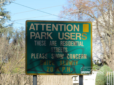
Street signage: Attention park users these are residential streets please show concern drive slowly 20 m.p.h with graffiti Newsletter No., 234, June 2017 Heritage Excursion - Saturday 1st July - Eltham Lower Park - Walk and Talk Eltham Lower Park has played an important part in the history of our area since the early days of European settlement when it was used by local residents as an informal racecourse. Prior to that its location at the junction of the Diamond Creek and the Yarra River made it an important meeting place for the Wurundjeri people. The park combines formal elements and sporting facilities with remnant bushland that is of environmental significance. It is home to sporting and horse riding clubs, popular play spaces and the Diamond Valley Miniature Railway, which attracts large numbers of visitors. The park will be the venue for our July excursion which will comprise a walk of about 3.5 km around the park and adjacent areas. Along the way we will discuss the history and natural history of the area. The path along the creek and the river provides a pleasant and scenic walk. This walk on Saturday 1st July is about 3.5 km in length and will take 2 to 2.5 hours. It will start at 2pm at the Main Road car park at the front of the park. (Melway ref 21 H 10). Born Digitalheritage excursion, activities, eltham district historical society, eltham lower park, sign, grafitti -
 Eltham District Historical Society Inc
Photograph, Liz Pidgeon, Heritage Excursion; Eltham Lower Park Walk and Talk, 1 July 2017, 1 July 2017
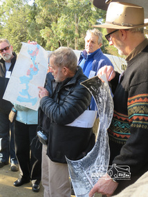
Local Historian Russell Yeoman and EDHS President Jim Connor with a map and aerial photograph of the area the heritage walk will cover. Newsletter No., 234, June 2017 Heritage Excursion - Saturday 1st July - Eltham Lower Park - Walk and Talk Eltham Lower Park has played an important part in the history of our area since the early days of European settlement when it was used by local residents as an informal racecourse. Prior to that its location at the junction of the Diamond Creek and the Yarra River made it an important meeting place for the Wurundjeri people. The park combines formal elements and sporting facilities with remnant bushland that is of environmental significance. It is home to sporting and horse riding clubs, popular play spaces and the Diamond Valley Miniature Railway, which attracts large numbers of visitors. The park will be the venue for our July excursion which will comprise a walk of about 3.5 km around the park and adjacent areas. Along the way we will discuss the history and natural history of the area. The path along the creek and the river provides a pleasant and scenic walk. This walk on Saturday 1st July is about 3.5 km in length and will take 2 to 2.5 hours. It will start at 2pm at the Main Road car park at the front of the park. (Melway ref 21 H 10). Born Digitalheritage excursion, activities, eltham district historical society, eltham lower park, russell yeoman, jim connor, guide -
 Glen Eira Historical Society
Article - Vegetation
Four items pertaining to vegetation within Caulfield: 1/2 copies of a booklet produced by the Caulfield City Council (undated) offering residents advice on the planting and care of trees within the district. Contains seven black-and-white photographs portraying various spots of vegetation within the district, plus nine black-and-white cartoons portraying the steps involved in correctly planting a tree. 2/An article from the Caulfield Contact, dated 04/1992, pertaining to Caulfield’s indigenous vegetation. Contains three black-and-white photographs of portraying three species of said vegetation – the swamp gum, the Kangaroo Apple and Poa grass. 3/An article from the Southern Cross, dated 13/05/1992, pertaining to Caulfield’s indigenous vegetation, and the efforts of groups and individuals such as the Caulfield Environment Group (CEG) to preserve it. Contains a black-and-white photograph of CEG member Paul Cain with a Red River Gum and large tussock grass, part of a re-vegetation program in a Murrumbeena linear park. 4/ A clipping from the Southern Cross, dated 20/05/1992, pertaining to the presence of Murray River red gum at Elsternwick primary school. Contains a black-and-white photograph of two pupils of the school, Craig and Emelia (surnames unmentioned), planting saplings.caulfield, plants, trees, caulfield city council, gardening, horticulture, landscape planning, caulfield contact, outer circle parklands, caulfield environment group, cain paul, smith colin, joint effort community house, outer circle railway, conservation of natural resources, murrumbeena, parks, minister for conservation, pullen barry, glenhuntly neighbourhood house, primary schools, elsternwick primary school, murphy street, mcinerney peter, elster canal -
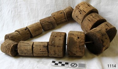
 Flagstaff Hill Maritime Museum and Village
Equipment - Net Floats, 20th century
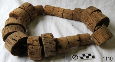
These net floats are handmade from lightweight cork wood and are used for suspending fishing nets in the water. Newspaper articles dated from 1848 to 1916 mention net fishing in Warrnambool's Hopkins and Merri rivers and Lady Bay. The Melbourne Argus dated January 11, 1848, published a quote from Captain Theobald of the vessels ELLEN and ELIZABETH, made on his first visit to Warrnambool "“…Fish are very plentiful here; on Christmas day a net was thrown into the Hopkins, and, after two or three draws, a boat load of beautiful fish was obtained…” The Argus, Melbourne, Sat. 29 May 1858, forwarded from The Examiner newspaper; "Extraordinary Fish. We have been presented with a very singular fish, caught by Mr. Meek in the Hopkins [Hopkins River, Warrnambool] last week. It is about three inches long, with a slate-coloured body, and a beautiful wing on each side. It was caught with other fish at night, in a net, and its eyes shone as bright as diamonds." A method for making cork net floats mentioned, in a 15th-century book, advised cutting the corks and then burning a hole through the centre of each one with a hot iron. The prepared corks were then joined together with a horsehair line. The cork's size and the line's thickness depended on the net's weight.The net floats are an example of fishing equipment used for many centuries and still in use today. In Warrnambool net fishing was a common practice from 1848 and became a livelihood for many fishermen. Net floats; cylindrical blocks of 16 corks threaded onto string with a hook-holding device at the end. warrnambool, shipwreck coast, flagstaff hill, flagstaff hill maritime museum, flagstaff hill maritime village, net floats, cork net floats, fishing, fisheries, fishing equipment, handmade, net fishing, fisheries act, andrew ferrier, william flett, warrnambool breakwater, merri river, hopkins river, captain theobald, ellen, elizabeth -
 Flagstaff Hill Maritime Museum and Village
Equipment - Net Floats, 20th century
These net floats are handmade from lightweight cork wood and are used for suspending fishing nets in the water. Newspaper articles dated from 1848 to 1916 mention net fishing in Warrnambool's Hopkins and Merri rivers and Lady Bay. The Melbourne Argus dated January 11, 1848, published a quote from Captain Theobald of the vessels ELLEN and ELIZABETH, made on his first visit to Warrnambool "“…Fish are very plentiful here; on Christmas day a net was thrown into the Hopkins, and, after two or three draws, a boat load of beautiful fish was obtained…” The Argus, Melbourne, Sat. 29 May 1858, forwarded from The Examiner newspaper; "Extraordinary Fish. We have been presented with a very singular fish, caught by Mr. Meek in the Hopkins [Hopkins River, Warrnambool] last week. It is about three inches long, with a slate-coloured body, and a beautiful wing on each side. It was caught with other fish at night, in a net, and its eyes shone as bright as diamonds." A method for making cork net floats mentioned, in a 15th-century book, advised cutting the corks and then burning a hole through the centre of each one with a hot iron. The prepared corks were then joined together with a horsehair line. The cork's size and the line's thickness depended on the net's weight.The net floats are an example of fishing equipment used for many centuries and still in use today. In Warrnambool net fishing was a common practice from 1848 and became a livelihood for many fishermen.Net floats; cylindrical blocks of 18 corks of various sizes threaded onto string.warrnambool, shipwreck coast, flagstaff hill, flagstaff hill maritime museum, flagstaff hill maritime village, net floats, cork net floats, fishing, fisheries, fishing equipment, handmade, net fishing, fisheries act, andrew ferrier, william flett, warrnambool breakwater, merri river, hopkins river, captain theobald, ellen, elizabeth -
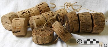
 Flagstaff Hill Maritime Museum and Village
Equipment - Net Floats
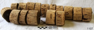
These net floats are handmade from lightweight cork wood and are used for suspending fishing nets in the water. Newspaper articles dated from 1848 to 1916 mention net fishing in Warrnambool's Hopkins and Merri rivers and Lady Bay. The Melbourne Argus dated January 11, 1848, published a quote from Captain Theobald of the vessels ELLEN and ELIZABETH, made on his first visit to Warrnambool "“…Fish are very plentiful here; on Christmas day a net was thrown into the Hopkins, and, after two or three draws, a boat load of beautiful fish was obtained…” The Argus, Melbourne, Sat. 29 May 1858, forwarded from The Examiner newspaper; "Extraordinary Fish. We have been presented with a very singular fish, caught by Mr. Meek in the Hopkins [Hopkins River, Warrnambool] last week. It is about three inches long, with a slate-coloured body, and a beautiful wing on each side. It was caught with other fish at night, in a net, and its eyes shone as bright as diamonds." A method for making cork net floats mentioned, in a 15th-century book, advised cutting the corks and then burning a hole through the centre of each one with a hot iron. The prepared corks were then joined together with a horsehair line. The cork's size and the line's thickness depended on the net's weight.The net floats are an example of fishing equipment used for many centuries and still in use today. In Warrnambool net fishing was a common practice from 1848 and became a livelihood for many fishermen.Cork net floats; lengths of 15 various sized cylindrical blocks of cork threaded onto string. warrnambool, shipwreck coast, flagstaff hill, flagstaff hill maritime museum, flagstaff hill maritime village, net floats, cork net floats, fishing, fisheries, fishing equipment, handmade, net fishing, fisheries act, andrew ferrier, william flett, warrnambool breakwater, merri river, hopkins river, captain theobald, ellen, elizabeth -
 Flagstaff Hill Maritime Museum and Village
Equipment - Net Floats, 20th century
These net floats are handmade from lightweight cork wood and are used for suspending fishing nets in the water. Newspaper articles dated from 1848 to 1916 mention net fishing in Warrnambool's Hopkins and Merri rivers and Lady Bay. The Melbourne Argus dated January 11, 1848, published a quote from Captain Theobald of the vessels ELLEN and ELIZABETH, made on his first visit to Warrnambool "“…Fish are very plentiful here; on Christmas day a net was thrown into the Hopkins, and, after two or three draws, a boat load of beautiful fish was obtained…” The Argus, Melbourne, Sat. 29 May 1858, forwarded from The Examiner newspaper; "Extraordinary Fish. We have been presented with a very singular fish, caught by Mr. Meek in the Hopkins [Hopkins River, Warrnambool] last week. It is about three inches long, with a slate-coloured body, and a beautiful wing on each side. It was caught with other fish at night, in a net, and its eyes shone as bright as diamonds." A method for making cork net floats mentioned, in a 15th-century book, advised cutting the corks and then burning a hole through the centre of each one with a hot iron. The prepared corks were then joined together with a horsehair line. The cork's size and the line's thickness depended on the net's weight.The net floats are an example of fishing equipment used for many centuries and still in use today. In Warrnambool net fishing was a common practice from 1848 and became a livelihood for many fishermen.Cork net floats; a set of two cylindrical blocks of varying sizes threaded onto strings.warrnambool, shipwreck coast, flagstaff hill, flagstaff hill maritime museum, flagstaff hill maritime village, net floats, cork net floats, fishing, fisheries, fishing equipment, handmade, net fishing, fisheries act, andrew ferrier, william flett, warrnambool breakwater, merri river, hopkins river, captain theobald, ellen, elizabeth -
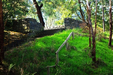
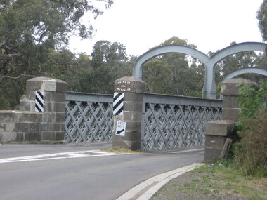 Ballarat Heritage Services
Photograph, Redesdale Bridge, 2016, 18/01/2016
The Redesdale Bridge is a wrought iron and timber structure with bluestone abutments which was installed over the Campaspe River in January 1868, although the bridge actually bears the date 1867. In 1859, the "Herald of the Morning", a ship carrying a cargo including 350 tons of ironwork for the Hawthorn bridge, caught fire and was scuttled a quarter of a mile off the jetty at Sandridge. A Melbourne salvaging firm raised the ironwork from the bottom of the bay, but after details of an arranged sale to the government caused a scandal in Parliament, the material was sold privately to the Melbourne foundry Langlands & Co. Two hundred tons of it was sold to the goldfields shires of McIvor and Metcalfe for only £1000. The bridge was designed by engineer T.B. Muntz and built by a contractor named Doran, and was completed late and considerably over budget at £6274. The bridge spans 45.7m across the river and has two roadways which are carried between three metal lattice girders in a through truss configuration. The design for the Hawthorn bridge had the deck supported over the trusses, and to stiffen the through truss configuration three sets of distinctive paired arches connect the trusses above the roadways. The roadway decking is constructed of longitudinally placed timbers on timber cross girders which rest on the lower chords of the trusses. (Heritage Victoria) A number of colour photographs showing the historic bridge at Metcalfe.metcalfe, shire of metcalfe, bridge, municipal boundary, shire of mcivor, redesdale bridge, campaspe river, t.b. muntz, doran -
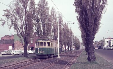 Melbourne Tram Museum
Album - Robert Thomson Slide Collection, "Melbourne 1965 April Box 2"
Photo - see pdf file for further information. Number Brief Description RT137 Peel St - tram 392 - "West Coburg via William St" - route 55 RT138 Batman Avenue - tram 954 - "Prahran" - route 77 RT139 Batman Avenue - tram 388 - "Wattle Park Elgar Rd" - route 70 RT140 Elizabeth Street - tram 949 - "North Coburg" - route 19 RT141 East Coburg Ter - tram 668 - "South Melb Beach" - route 1 RT142 Royal Pde Jct - tram 764 - "North Coburg" - route 19, Haymarket, Hotel Gresham RT143 High st - tram 979 - "City Spencer St" - route 90, Clifton Hill RT144 High St - tram 1036 - "East Preston" - route 88, Clifton Hill RT145 tram 52 - "Footscray" - route 82, Maribyrnong River bridge reconstruction RT146 tram 802 - "City via North Melb" - route 57, tram 599, West Maribyrnong - Maribyrnong River bridge reconstruction RT147 tram 52 - "Footscray" - route 82 Raleigh Road, near Rosamond Road RT148 tram 52 - "Footscray" - route 82 at Moonee Ponds, Ascot Vale Road Demonstrates the work of Robert Thomson in photography, collection and/or production of slidesAssembled album in a black presentation folder of 12 colour slides, collected or produced by Robert Thomson. All photographs have been scanned and placed on the Museum's G drive. A list of all photographs with details has been compiled. melbourne, tramways, trams -
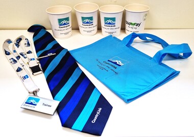 Wodonga & District Historical Society Inc
Memorabilia - CountryLink Collection
For residents of Northeast Victoria, railway services have provided a critical link between the area and state capital cities. CountryLink was established in January 1989 under the Transport Administration Act 1988. It was a passenger rail and road service brand that operated in regional areas of New South Wales, and to and from Canberra, Brisbane and Melbourne. CountryLink operated rail services a fleet of XPT and locomotive-hauled passenger trains. The Southern region of the Country Link network covered New South Wales districts of Illawarra, South Coast, Snowy Mountains, South West Slopes, Southern Tablelands, Riverina and Sunraysia regions plus the Australian Capital Territory and parts of Victoria. The Government of Victoria contributed to the provision of these services. Services ran along the Main South line from Sydney Central station to Albury before continuing on the North East line to Southern Cross station in Melbourne. The Sydney/Melbourne Express ceased in November 1993 and was replaced by an XPT in November 1993 In December 1994, a daylight service to Melbourne resumed by extending the Riverina XPT from Albury. In July 2013, CountryLink was merged with the intercity services of CityRail to form NSW TrainLink.These items are connected to a major transportation system in eastern Australia.A collection of uniform items and memorabilia from the CountryLink rail service. They include a tie and tiepin, staff badge and lanyard, cups and a bag with CountryLink logo.Tag on tie: Stylecore Corporate Wear Australia/ Polyester/ Made in England On all items: CountryLinkcountrylink, australian railways, countrylink uniforms -
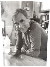 Falls Creek Historical Society
Photograph - Portrait Ory Frueauf
This photograph was taken circa 1981 - 1982 by Tourism Victoria. Orest “Ory” Frueauf was born in Kharkov, Russia in 1925 and moved to Germany with his family to escape persecution. He was conscripted to the German Army during the Second World War. He was a POW until 1948. He was recruited by a French construction company to work as and interpreter on a hydroelectricity project in Tasmania. Ory then moved to work on the Snowy Mountain Scheme including driving a truck to fill the wall of the Rocky Valley dam. In 1952 Ory was recruited by the Albury Ski Club as its lodge supervisor. That year he also entered into a business partnership with Cecil Dobson, running the general store “Whitehaven” and Post Office at Falls Creek. They extended their business by adding accommodation turning Whitehaven into one of the best commercial lodges at Falls Creek. Ory and Cecil dissolved their business partnership in 1963 and Ory went on to build a new lodge called “Snowhaven” at the site of the present day Frueauf Village, Falls Creek. The trail known as Ory's Trail is also named in his honour. Ory retired to Tawonga, Victoria in 1992 and passed away in 1999.This image is significant because it portrays a pioneer of Falls Creek.A4 size black and white photograph of Ory Frueauf standing at the bar at Snowhaven Lodge with Vovka-Finlandia VodkaOn back of photograph: Orest Freauf 1925-1997. 1925 - Born in Kharkov, Russia, 1951 Tasmania Hydro Electric Co; 1954 Howman's Gap, Kiewa Hydroelectric Scheme; 1955 Falls Creek Trading and Transport Co; 1957 Winterhaven Ski Lodge; 1963 Snowhaven Ski Lodge; 1992 Tawonga Southory freauf, hydro electric, tourism victoria, winterhaven ski lodge, snowhaven ski lodge, snow, orest frueauf -
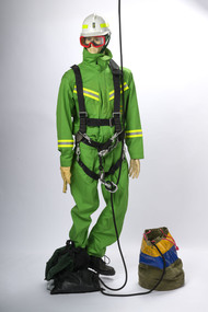 Department of Energy, Environment and Climate Action
Rappel model with protective equipment, harness and rope drop bag
Based on the earlier successful tests with the RAAF Dragonfly in 1948-49, together with the effective use of aircraft during the extensive Gippsland bushfires in March 1965, the Forests Commission took the plunge and contracted its own dedicated Bell 47G in the summer of 1965-66. This was an Australian first for any forest or bushfire agency. Rappelling trials at Snowy Plains and Tallangatta soon followed, which led to operations based at Heyfield with a two-man crew to quickly attack small fires in remote locations. The Heyfield rappel crew was another Australian first and remained in place for the following two fire seasons but lapsed after concerns from the Civil Aviation Safety Authority (CASA) about the stability of the small and underpowered Bell 47G. Later in 1982, after nearly 18 years absence, the Commission recommenced rappelling operations using larger and more powerful National Safety Council (NSCA) Bell 212 and Bell 412 helicopters based in Sale, Gippsland. During the 1983 bushfires, a specially trained and equipped FCV crew rappelled by rope from a hovering NSCA helicopter to suppress a small fire in remote terrain in the Orbost Forest District. Rappel model with protective equipment, harness and rope drop bagforests commission victoria (fcv), bushfire, bushfire aviation, safety equipment -
![Junction of the Rivers Yarra and Watt, Near Healesville / [by] Nicholas Caire, circa 1876](/media/collectors/550653872162f11fb04854aa/items/577740e5d0cdd10a5c0de011/item-media/57774153d0cdd10a5c0e0662/item-fit-380x285.jpg) Kew Historical Society Inc
Kew Historical Society IncPhotograph, Anglo-Australasian Photographic Company, Junction of the Rivers Yarra and Watt, Near Healesville, c. 1876
Nicholas Caire was born on Guernsey in the Channel Islands in 1837. He arrived in Adelaide with his parents in about 1860. In 1867, following photographic journeys in Gippsland, he opened a studio in Adelaide. From 1870 to 1876 he lived and worked in Talbot in Central Victoria. In 1876 he purchased T. F. Chuck's studios in the Royal Arcade Melbourne. In 1885, following the introduction of dry plate photography, he began a series of landscape series, which were commercially successful. As a photographer, he travelled extensively through Victoria, photographing places few of his contemporaries had previously seen. He died in 1918. Reference: Jack Cato, 'Caire, Nicholas John (1837–1918)', Australian Dictionary of Biography.An original, rare photograph from the series 'Views of Victoria: General Series' by the photographer, Nicholas Caire (1837-1918). The series of 60 photographs that comprise the series was issued c. 1876 and reinforced a neo-Romantic view of the Australian landscape to which a growing nationalist movement would respond. Nicholas Caire was active as a photographer in Australia from 1858 until his death in 1918. His vision of the Australian bush and pioneer life had a counterpart in the works of Henry Lawson and other nationalist poets, authors and painters.Albumen Silver Photograph, mounted on Board.printed in ink on support l.c.: JUNCTION OF THE RIVERS YARRA AND WATT, NEAR HEALESVILLE. / COPYRIGHT REGISTERED. printed in ink on support reverse c.: VIEWS OF VICTORIA. / (GENERAL SERIES.) / No. 3. / JUNCTION OF THE RIVERS YARRA AND WATT, NEAR HEALESVILLE / The junction is situated about 3 miles from Healesville, and 35 miles from the mouth of the Yarra. The souces / of the Watt are to be found at the head of the Black Spur, and, being fed by a number of creeks and springs, its / waters gain considerable force for several miles before joining those of the Yarra. The "Old Bridge," at the junction, / is the name given to this crossing-place, which has been partly swept away by late floods. The depth of the Yarra here / is from 15 to 20 feet; that of the Watt, about 10 feet. printed in ink on support reverse l.c.l.: J.W. FORBES, Agent, printed in ink on support reverse l.c.: ANGLO-AUSTRALASIAN PHOTOGRAPHIC COMPANY, MELBOURNE. printed in ink on support reverse l.c.r.: 10 Temple Court, Collins Street West.nicholas caire (1837-1918), yarra river, watt river, bridge, wooden bridge, healesville -
 Dandenong/Cranbourne RSL Sub Branch
Photograph - Large frame containing 4 photographs, Circa 1940s
Large wooden frame with 4 black and white photographs of M V Krait and crew.Photograph # 1 depicts M V Krait manned by "z" Special Unit Troops. Photo # 2 shows M V Krait who sank 38,000 tons of Japanese shipping in raids they carried out. Anchored in Hawksbury River N.S.W. Photo # 3 shows the crew of M.V. Krait blacking their skins wearing sarongs to resemble fishermen. (Note Japanese flag on rear of ship.) Photo # 4 the M V Krait en route to Singapore. -
 Kiewa Valley Historical Society
Photograph - 30 black and white photographs (assorted sizes) plus page from a newspaper and copied article on A4 paper, c1880's c1910 - 1920 (photographs) Newspaper 1961
K2,3 and4 are of the Kiewa River and two of the bridges spanning the river along the valley. K3 and K4 would have been taken in the 1880's and show the type of trees and plant growth along the river prior to land clearing for farming. K5 is of the Running Creek Cricket Team and therefore there was sufficient population in the area to form and maintain a team as well as have other teams in the relatively near vicinity to provide competition. Note the horse drawn cart which provided transport. Date taken is unknown but possibly c 1910. The Mt. Buffalo Chalet was built in 1910 by the Victorian Government. It was Australia's first ski resort and has served generations of skiiers, hikers and families over the years. It was built for 3195 pounds and has had stories and wings added since and is the largest timber building in Australia. B4 is the earliest photo in this group as the garden is in early stages of development - the other photos show the growth of the shrubs and would be taken about c 1920. Note the cars and motor bikes. It closed in 2006. The other photos are of general interest only but interesting to see that there were donkey's grazing. There is no information as to their purpose on Mt. Buffalo. Four different Kiewa Valley families are represented in the photographs. Their descendants still live in the Valley and carry on the traditions of beef and dairy farming. Of particular interest is the photo of Miss Marjorie Clemence, the first School Teacher of Upper Gundowring School. Gundowring pastoral run was taken up in 1838 and occupied by framers in the 1860's. The area was known as Gundowring and Upper Gundowring. The Gundowring School was opened in 1871 and most likely the Upper Gundowring school would be built at the same time. It was School No. 2733 and situated in Boyd Road. It closed in 1953 when the Kiewa Consolidated School opened. The newspaper page describes the activities in which the local community of Kergunyah were in engaged in that period - Red Cross, Fire Brigade, cattle round up and some of the identities involved. The article photocopied from the Yackandandah times states that he (Norman Coad) "was sent to the Ovens District Hospital, Beechworth for treatment" which would mean that this was the closest hospital to the Kiewa Valley for emergencies in 1912.The Kiewa Valley photographs are of social significance showing two of the early bridges allowing the community easy access to both sides of the river and also the tree and plant growth before land clearing for farming. The photos of Mt. Buffalo Chalet have social, architectural and historical significance. the Chalet has been used by skiers, bush walkers and day trippers since its completion in 1910 and its closure in 2006. It is listed in the Victorian Heritage Register. The family photographs are of social and historical significance as they are of early farming families in the Kiewa Valley and also depict the dress, of both men and women) in the late 1880's. The write up in the Weekly Times has social significance as it depicts the social and farming activities and photos of the local residents from around that area. The article from the Yackandandah Times is of a personal nature with concern for the individual involved. Note: There is a photo of the gentleman mentioned in the article (Mr. Norman Coad) in the Families of the Kiewa Valley (F4) as above.30 black and white photographs - 5 of the Kiewa Valley, 8 of families of the Kiewa Vallley and 17 of Mt. Buffalo. Various sized photos. Page from the Weekly times and copied article from the Yackandandah Times on A4 sheet.(Note for easier identification they have been numbered and grouped - K1-5 (Kiewa Valley), F1-8 (Families) and B1-17 (Mt. Buffalo). K1: handwritten in ink, lower L hand corner "Bogong in the distance". K2: handwritten in ink lower L hand corner "Mongan's Bridge or Towonga". K3 handwritten in ink "Taken from Mongan Bridge looking up stream". K4 - no inscription. K5: handwritten in ink, back of photo "Running Creek Cricket Team". F1: handwritten in ink on back "Mrs. Heap" and lower down in pencil "1880's". F2 handwritten in pencil at top of back phot "Land at Tawonga TROVE The Y'dah Times 20/2/1913" and lower down in ink "Henry Ellis Larkin". F3: handwritten in ink bottom edge "Mrs Coad". Note that this photo is a postcard. F4: Written in ink lower edge "Norman Coad". Note this photo is also a postcard. F5: Lower left corner in Ink "Harry Larkin". F6: lower half back of photo, in ink "Bernie Maddison". F7: on back of photograph in ink "Miss Marjorie Clemence first School Teacher Upper Gundowring: and underneath, in pencil "C1880's". F8: Handwritten in ink on back of photo "Frank & Mrs. Keat & Lesley of Tawonga". Lower down in pencil "c1912-1914". B1: Back of photo in ink "The Chalet Mt. Buffalo". B2: no inscription. B3: "chalet at Bufflo" in ink lower left corner. B4: This is a post card. Written in ink is "Mt. Buffalo Chalet". B5 - B10 printed in ink, lower left corner "Buffalo". B11: no inscription. B12: "Mt. Buffalo" lower R corner. B13: "Buffalo?". B15: Printed in ink lower edge "Picnic at Buffalo". B16: "Donkeys on Mt. Buffalo" printed in ink lower edge. B17: handwritten in ink across back of photo "Donkeys & top of Mt. Buffalo with the Monileith in the distance". A4 sheet of paper describing an accident to Mr. Norman Coad. Under article is : Yackandandah Times (Vic: 1890 - 1931), Thursday 18 July 1912, page 3. A page torn from the Weekly Times, June 14, 1961 and entitled "Kergunyah has picturesque setting". kiewa valley, farming, families, kergunyah, gundowring upper, mt. buffalo chalet, briggs family, larki family, coad family, clemence family, laskowski collection -
 Warrnambool and District Historical Society Inc.
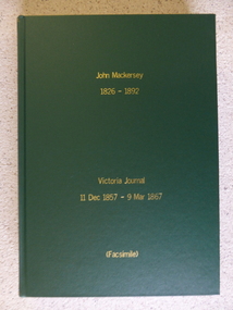
Book - Facsimile: John Mackersey 1826-1892, Victoria Journal 1857-1867, 2014
This diary relates to the property Kenilworth which is situated near Cavendish, 16 miles from Hamilton on the Wannon River. It was taken up by Thomas Norris in 1839 and originally carried 800 cattle and 20000 sheep on 63000 acres. By 1858 it was in the hands of John Mackersey and Thomas Bostock. In 1859 it belonged outright to John Mackersey who was there until 1870. He was considered a worthy son of a Presbyterian minister and was well regarded in the district for his contributions in church, sport and sheep breeding... However he did not do well and lost the property before going to New Zealand in 1870.This diary has detailed entries over a number of years which provides an insight into life in the 1860’s. It has a significance for Warrnambool as John Mackersey and Augustus Bostock were at one stage business partners.Hard green cover with gold lettering. 534 pages of facsimile copied diary entries. The entries date from 1857 to 1867. Acknowledgements to The State Government of Victoria, State Library of Victoria, Hamilton History Centre, Dr G Handbury AO, Margaret Gardiner, Godfrey and Margaret Mackersey, L Alan Brumley, M P Heuval.john mackersey, thomas norris, kenilworth, warrnambool history -
 Kiewa Valley Historical Society
11 Black and White photographs of the Rocky Valley area, c1948
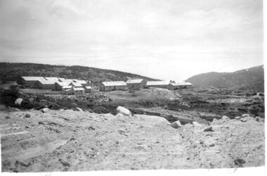
In October 1947 construction was commenced on the erection of the workmen's camp at Rocky Valley. Also in 1947 construction of a stream diversion was commenced to allow excavation to commence for the dam wall. In the summer of 1948/49, stripping of the foundation area on both sides of the river was carried out. Weather conditions were not always favourable during the construction, particularly 1955/56 summer, and work would have to cease each year for the winter season due to the severe conditions. The dam is a earth and rock fill structure with a height of about 30.5 metres and crest length 518.16 metres and was completed in March, 1959.These photographs show the type of terrain in the area prior to the construction and filling of Rocky Valley Dam. Also of interest is the type of accommodation provided for those working on the construction and the early cranes available in the 1940/50's. Of historical importance to understand the conditions in the early construction of the Kiewa Hydro Electric SchemeEleven small black and white photographsPhoto No. 1 - on the back, printed in ink"Rocky Valley - New Mess & offices Dec. 1948". In pencil '14 on the back Photo No. 2 - on the back, printed in ink "Rocky Valley Camp. October 1948". Also stamped on the back "998L" Photo No. 3 -on the back, printed in ink "Rocky Valley Hostel October 1948". Also stamped on the back '998L' Photo No. 4 - on the back, printed in ink "Spion Kopje from bedroom window. October 1948". Stamped on the back '998L'. Photo No. 5 - on the back, printed in ink "Rocky Valley Basin Dec. 1948." In pencil on back, 14. Photo No. 6 - on the back, printed in ink "Site of Wall for Rocky Valley Dam Dec. 1948". In pencil on back, 14. Photo No. 7 - On the back, printed in ink "Commencing of Diversion Tunnel Rocky Valley December 1948". In pencil on back, 14. Photo No. 8 - on the back, printed in ink "One of the two electric cranes at Rocky Valley December 1948". In pencil on back, 14. Photo No. 9 - on the back, printed in ink "'Rapier' (H.Y.) electric crane Rocky Valley December 1948". In pencil on back, 14 . Photo No. 10 - on the back, printed in ink " Pretty Valley Pump line construction Mt. Cope in Background Nov 1948. Circular stamp with the words 'print by Wilson White Albury' in the circle. Photo No. 11 - on the back, printed in ink "Stringing cable on Ruined Castle October 1948. Same stamp as No. 10. In pencil '31'. rocky valley; pretty valley; ruined castle; bogong high plains; kiewa hydro electric scheme -
 Kiewa Valley Historical Society
7 small black and white photographs of Pretty Valley, c1948
In 1947 it was proposed to construct a dam on the Pretty Valley branch of the East Kiewa River. This was part of the initial planning in 1937. The Pretty Valley Reservoir was to be part of a pumped-storage scheme with a pumping station located immediately below the main structure. Preparatory work was commenced in 1946 with erection of staff accommodation. Between 1947 and 1950 the main camp was erected, access roads, constructed and banks and benches at the dam site undertaken. Following the financial crisis in 1951, a review of the scheme was carried out and work ceased in June 1951. Construction of the dam was deleted from the programme of works and all buildings removed.A pictorial history of part of the initial planning in 1937 for a dam to be constructed at Pretty Valley as part of the Kiewa Hydro Electric Scheme.7 small black and white photographs of Pretty ValleyAll photos have a circular stamp on the back with 'Print by Willson White Albury' enclosed. Photo 1 - on the back, handwritten in ink 'New 22Kv pump line - Pretty Valley Nov. 1948'. In pencil '18'. Photo 2 - On the back, handwritten in ink 'Pretty Valley - Staff mess on right Nov. 1948'. In pencil '18'. Photo 3 - On the back, handwritten in ink 'Pretty Valley Basin - looking S.E. Nov. 1948'. In pencil '5'. Photo 4 - On the back, handwritten in ink 'New pump 22Kv line, Pretty Valley - looking towards Mt. Mackie. Nov. 1948'. In pencil '5'. Photo 5 - On the back, handwritten in ink 'Pretty Valley. Mt. Cope just out of picture extreme right. Nov. 1948'. In pencil '78'. Photo 6 - on the back, handwritten in ink 'View from Pretty Valley Ruined Castle in Background Nov. 1948'. In pencil '78'. Photo 7 - on the back, handwritten in ink 'Pretty Valley Pump line (Nov. 1948)'. In pencil'78'.construct, dam, pretty valley -
 Warrnambool and District Historical Society Inc.
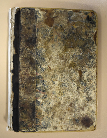
Administrative record - Warrnambool Waterworks Newspaper Cuttings, 1891 to 1917
This ledger contains newspaper cuttings form The Warrnambool Standard newspaper from May 1891 to October 1917. The cuttings are reports of meetings of the Warrnambool Waterworks Trust. In the early days of Warrnambool domestic water and water for fire suppression was supplied by tanks, wells and springs. In the 1870s various schemes were proposed to find a better supply of water. In 1891 the Warrnambool Waterworks Trust was formed using water from the Merri River. This system lasted until 1939 when the Warrnambool water supply came from the Otway ranges. This system is still the water supply for Warrnambool today. The cuttings in this ledger will be useful for research.This is a ledger with a brown mottled cover and a leather spine and leather corners. The spine is partly detached. The front cover has a label pasted on it. The pages originally had hand written entries (The Minutes of a Warrnambool organisation). Newspaper cuttings have been pasted over the original writing. Warrnambool Waterworks Trust Newspaper Reports From 19th May 1891 To --- warrnambool waterworks trust, warrnambool water supply -
Warrnambool and District Historical Society Inc.
Document - Documents (3) of Farnham Cheese and Butter factory, 1890s (originals)
These three sheets are copies of the originals and relate to the establishment of the Farnham Cheese and Butter Factory in Dennington (Warrnambool). The name 'Farnham' is the name of the Special Survey in the area first purchased by William Rutledge and also the name of the Rutledge property at Dennington. In 1889 WIlliam Rutledge (Junior) and Thomas Palmer established the Farnham Cheese and Butter Factory on the banks of the Merri River at Dennington. In 1890 they sold the factory to a farmers' co-operative. Farnham had a high reputationfor butter=making when the factory was in existence. The factory was bought out by Nestles about 1909 with that company establishing its factory on the same area.in 1911. These documents are of interest as the Farnham Cheese and Butter Factory was one of the earliest of its type in the Western District and won a Gold Medal in 1909 for butter-making at the Islington Dairy Show in competition with other butter-making countries in the world..1 sheet of paper with black and white map showing location of factory in Dennington (copy) .2 An A3 size piece of paper with a sketch map and typed material showing a Certificate of Title (copy) .3 An 3 size piece of paper with a sketch map and typed material showing a Certificate of Title (copy)farnham cheese and butter factory, nestles factory warrnambool -
 Warrnambool and District Historical Society Inc.
Medallion, Australian Felmongers Wool Sorters
This is a badge of an Australian association of fellmongers, wool sorters and scourers. This group may have been part of the Amalgamated Fellmongers, Wool Sorters and Wool Scourers Union of 1912-1918 or it may have been an earlier association. A fellmonger was a dealer in the hides or skins of animals, especially sheep, or a person who removed the skins from animals. There were several fellmongery and wool scouring establishments in 19th century Warrnambool and district. These included the Dallimore Fellmongery at Lake Gillear, the Bennett Merri Bank Fellmongery at Dennington and the fellmongery businesses of James Evenett and Henry Mawbey on the Merri River in South Warrnambool.Although it has no known local provenance, this badge is of interest because there were several fellmongery establishments in the Warrnambool district in the 19th century so it may have belonged to a local person.This medallion has a gold coloured image of a suspended lamb on a circular royal blue enamel background which in turn is surrounded by a white enamel annulus with text. The external brass edging is filigree. The medallion has an attached ring at the top with narrow gold ribbon threaded through an additional ring FELLMONGERS WOOL SORTERS & SCRS' . AUST. WOOLANDSKIN 82? G.P.O.PLACE W fellmongers, warrnambool history, dallimore fellmongery, bennett merri bank fellmongery, james evenett, henry mawbey -
 Eltham District Historical Society Inc
Photograph - Aerial Photograph, Landata, Eltham, Vic, Apr. 1972
Centred on present day Mays Road at Stringybark Road, Eltham bounded by Nyora Road to north, Yarra River to south, Reynolds Road to east and Bible Street to west. Historic Aerial Imagery Source: Landata.vic.gov.au Aerial Photo Details: Project No :985 Project : MELBOURNE 1972 Run : 28 Frame : 209 Date : 04/1972 Film Type : B/W Camera : RC10 Flying Height : 5700 Scale : 9600 Film Number : 2635 GDA2020 : 37°43'33"S, 145°09'28"E MGA2020 : 337647, 5823013 (55) Melways : 22 B8 (ed. 42)aerial photo, neil webster collection, 1972-04, eltham, bible street, mays road, melway 22b8, nyora road, reynolds road, stringybark road, yarra river -
Eltham District Historical Society Inc
Document - Folder, Oyston, Peter
Peter Oyston died in 2011. His career included being Founding Dean of drama at the Victorian College the Arts and director of Playbox Theatre. He was a champion of theatre companies including The Murray River Performing Group, The Flying Fruit Fly Circus, West Theatre and Theatreworks. He taught at the Royal Academy of Dramatic Art in London and directed more than 200 productions in Australia and other countries. He had one daughter. Contents Newspaper article: "Director takes his curtain call", Diamond Valley Leader, 19 October 2011, Obituary of Peter Oyston.Newspaper clippings, A4 photocopies, etcpeter oyston, victorian college of the arts, bend of islands, playbox theatre, the fying fruit fly circus, theatreworks, royal academy of dramatic arts london, dominque oyston, ray mooney, west theatre, the murray river performing group -
 Mission to Seafarers Victoria
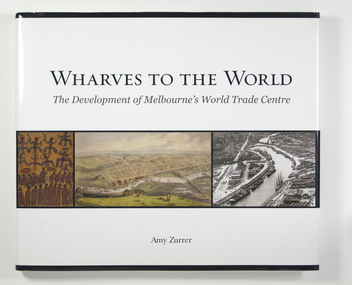
Book, Melbourne Books, Wharves To The World: The Development Of Melbourne's World Trade Centre, 2011
Wharves to the World: The Development of Melbourne's World Trade Centre is a photographic chronicle of the history of the World Trade Centre and its surrounds. The book traces the journey of land and the buildings that occupied it - from its beginnings with the Wurundjeri people to its role as a trading hub in early Melbourne, then as the site of the modern-day World Trade Centre, and now as part of a flourishing residential and commercial Precinct. As with any major project The World Trade Centre has face its share of fêlures, but despite thèse it has become an integral part of the City. So it goes that was once home to swampland and the City morgue has been transformer into a Diamond of the Yarra River.A 128-page book of printed matter, photographs, engravings and drawings. The hard cover is white with the title in gold lettering on the front. The dust-cover is also white with black lettering. Along the lower half of the cover, front and back, is a strip of six photos, three coloured and three black and white. 128 p. : ill. (some col.), ports. ; 22 x 25 cm.non-fictionWharves to the World: The Development of Melbourne's World Trade Centre is a photographic chronicle of the history of the World Trade Centre and its surrounds. The book traces the journey of land and the buildings that occupied it - from its beginnings with the Wurundjeri people to its role as a trading hub in early Melbourne, then as the site of the modern-day World Trade Centre, and now as part of a flourishing residential and commercial Precinct. As with any major project The World Trade Centre has face its share of fêlures, but despite thèse it has become an integral part of the City. So it goes that was once home to swampland and the City morgue has been transformer into a Diamond of the Yarra River.yarra yarra tribe, early melbourne, world trade centre, melbourne, southbank, northbank, australian wharf, siddeley street, waterfront, amy zurrer, wurundjeri, spencer street bridge, north wharf, riverlee, wtc, wharf, harbor trust, sir john coode, harbour trust, little dock, polly woodside, wharfies, divers -
 Greensborough Historical Society
Photograph - Digital Image, Pioneer Reserve 2014 -1, 21/05/2014
Pioneer Reserve, Greensborough is a small park on the corner of St Helena and Diamond Creek Roads. It is adjacent to the site of Greensborough's first bridge across the Plenty River, c. 1864 - 1960s. The shelter, viewing platform, retaining wall and entrance are built from the bridge's massive bluestone arched abutments dismantled between 1974 and 1983. Pioneer Reserve is historically significant for its formative association with noted local landscape designer Gordon Ford in 1968, and it is likely that remnant large field stones at the entrance drive to the Reserve remain from his design. Photograph by Marilyn Smith 2014.Digital copy of colour photograph. -
 Greensborough Historical Society
Certificate of Title, Supreme Court of Victoria (Probate Division) et al, Certificate of Title Vol. 2567 Fol. 294, Vol. 3134 Fol. 605, 22/05/1895
Title Vol. 2567 Fol. 294 in the name of The Greensborough Estate Company Limited, 164 acres four and a half perches, being part of Crown Portion 17 Parish of Keelbundora, County of Bourke. Dated 22nd May 1895. Northern boundary Greensborough Road (now Grimshaw Street), Southern boundary Nell Street, Eastern boundary Plenty River, Western boundary road (now named McDowell Street); Title Vol. 3134 Fol. 605 in the name of Adolphe Frederic Seelenmeyer, land as described above, LP 4759 and transfers and other instruments to 9 March 1948Folder containing two Certificates of Title (3p. + 9 p.) and twenty pages of miscellaneous documents, including historical summary, brief biography of A. F. Seelenmeyer, two Death Certificates and photocopied extracts from probate documents, as listed in table of contents, ed. by Peter Simmenauergreensborough, greensborough estate company limited, grimshaw street greensborough, plenty river, nell street greensborough, mcdowell street greensborough, adolphe frederic seeley, formerly seelenmeyer, adolfe frederic seelenmeyer -
 Uniting Church Archives - Synod of Victoria
Photograph, 1985
Rev Frank Morris Ordained in the Methodist Church 1966, Minster at Casterton 1966-1968, Yarram 1969-1971, Tasmania LA 1972-1989, Glamorgan 1990-1993, Hobart City Centre 1994-1995, PR 1995. Rev Des Ivens Ordained 1970 SA Minster at Robe 1963, Port MacDonnell 1964-1966, Plympton (Hare St) 1967, Bute 1968-1970, Rocky River (Laura) 1971-1973, Barunga Range 1974-1976, Kangaroo Island 1977-1981, Huon Tas 1982-1985, SA, Wallaroo 02.86 B & W waist length photograph of the Rev. Frank Morris and the Rev. Des Ivens in conversation.rev. frank morris; rev. des ivens; casterton; yarram; hobart city centre; robe; port macdonnell; plympton; bute; rocky river; barunga range; kangaroo island; huon tasmania; wallaroo -
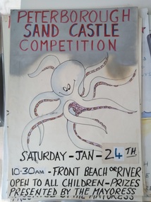 Peterborough History Group
Poster - Sandcastle Competition Annual Advertising Posters
The Peterborough Sandcastle competition has been running for at least 80 years. Wokka Moore was the first "Lady Mayoress", judge of the competition, who arrived with great ceremony using different means of transport over the years - always accompanied by a "Lady in Waiting". Traditionally, this was held on the Australia Day long weekend. Competition was divided into age groups, and the venue depended on whether the river was open or closed. (If it was open there is no sand on the Front Beach). Materials used could only be what was found on the beach. Currently (2021) the Sandcastle Committee is calling for photos, memorabilia and details of winners from over the years.This event has been running for a very long time , apparently uninterrupted. It is significant to the town because of its inclusive nature - there was high anticipation and planning by the children. The roles of Lady Mayoress and Lady in Waiting were keenly sought. Wokka Moore did the job for a long time then passed the baton. Others who were honoured over the years include Alec Calvert, eight posters of various sizes with hand drawn pictures, some with dates but not year of event.sandcastle competition, peterborough, peterborough sandcastle competition, traditional summer event peterborough -
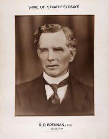 City of Greater Bendigo - Civic Collection
Photograph - Portrait of Shire Secretary Brennan, Unknown
The district of Strathfieldsaye was proclaimed in 1861 and named a Shire on the 17th September in 1866. It remained a shire until amalgamation in 1994 when it became part of the City of Greater Bendigo. The Shire was located 8 km to the south- east of Bendigo and covered an area of 601 square kilometres and extended from the Calder Highway to the Coliban and Campaspe Rivers. The shire's administration centre was in Strathfieldsaye until 1972 when new offices were opened in Kennington. Secretary Brennan, son of Councillor M. Brennan was appointed after his fathers death to the role and according to the The Bendigo Independent was in the role in 1917. See References.Framed black and white head and shoulder portrait of Councillor Brennan. Profile slightly to left. Cut rectangle cream mount. Hand written title top and lower centre. Shire of Strathfieldsaye / R. B. Brennan, Esq / Secretarystrathfieldsaye shire council, secretary strathfieldsaye shire