Showing 11595 items matching " maps"
-
 Bendigo Military Museum
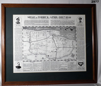
Map - MAP, FRAMED TOBRUK, Post WW2
... maps ...Wooden framed, glass fronted, green bordered, black & white map with history.“Siege of Tobruk April - Decr 1941 Cartography By James Emery History By Chester Wilmot”framed, maps, tobruk, passchendaele barracks trust -
 Clunes Museum
Map, F.W. NIVEN EMBOSSER
... MAPS ...SCROLL - SURVEVOR MAP AND PLAN OF NEW CRESWICK GOLD FIELDS SURFACE LEVELSlocal history, document, maps, mining - maps -
Whitehorse Historical Society Inc.
Map, Melbourne Metropolitan Area Base Map series. Sheet 214, c1960
... maps ...Map showing northern section of the City of Nunawading together with parts of Shire of Doncaster and Templestowe.Map showing northern section of the City of Nunawading together with parts of Shire of Doncaster and Templestowe. Shows roads, creeks, block numbers and contours at 5 feet vertical increments. Note on map: 'prepared ... from State Aerial Survey, January 1957 and Cadastral Survey information February 1959'.Map showing northern section of the City of Nunawading together with parts of Shire of Doncaster and Templestowe. maps, city of nunawading, shire of doncaster and templestowe -
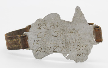 4th/19th Prince of Wales's Light Horse Regiment Unit History Room
Souvenir - Trench Art, Bracelet Metal Map of Australia with leather strap, Mid 1917
Wrist badge for self identifiaction made by 2381 C.W. Smith as Trench Art during service in WW1Manufactured during WW1 by C.W. Smith as an item of identification in case of an adverse occurrence during his operational serviceHand made metal map of Australia with brown leather band hand stitched and brass metal buckle“2381 C.W.SMITH/1ST FIELD SQDN./A.N.Z. MTD DIV M.” Inscribed on front of metal mapwrist, badge, metal -
Whitehorse Historical Society Inc.
Map, Nunawading, 1965
Map of Nunawading and surrounds: Eltham, Templestowe, Doncaster, Box Hill, Warrandyte, Park Orchards, Ringwood, Croydon, Lilydale and Mooroolbark .Map of Nunawading and surrounds: Eltham, Templestowe, Doncaster, Box Hill, Warrandyte, Park Orchards, Ringwood, Croydon, Lilydale and Mooroolbark . UBD map issued by Gazette Newspapers. Scale: 1:50,000Map of Nunawading and surrounds: Eltham, Templestowe, Doncaster, Box Hill, Warrandyte, Park Orchards, Ringwood, Croydon, Lilydale and Mooroolbark . blackburn, nunawading, vermont, forest hill, burwood east -
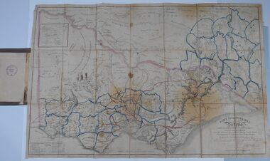 Bendigo Historical Society Inc.
Document - HARRIS COLLECTION: HAMS SQUATTING MAP OF VICTORIA, PORT PHILLIP DISTRICT, NSW
Thomas Ham was a cartographer, engraver, lithographer and publisher in Victoria and Queensland. He compiled and printed several editions of his squatting map, beginning with A map of Australia Felix in 1847 and changing its title to Ham's squatting map of Victoria in 1851. The 1851 edition was accompanied by a key listing the names of all the squatters within squatting districts and counties. Later editions show the existing counties, but some areas of Gippsland and the Australian Alps are still described as 'unsurveyed country'. (State Library Victoria https://www.slv.vic.gov.au/squatting-map-victoria)Folding map enclosed in burgundy cover. Map backed by cloth and bound. Rare, early map of Victoria and neighbouring Port Phillip District of New South Wales. Written on bottom RH corner of map: Ham's Squatting Map of Victoria ( Port Phillip District, New South Wales ) carefully corrected to this date from the Colonial Government Surveys, Crown Lands, Commissioners & Explorers Maps, Private Surveys & c. Respectfully inscribed (with permission ) to His Excellency Sir Chas A. Fitz-Roy Knt, Governor of New South Wales &c &c by his Obedient Servant, The Compiler, 1851. Compiled, engraved and published by Thomas Ham, Melbourne. Proposed and original boundary ( in legend) have been coloured in in blue and pink ink ( later addition ?) Number on map show 'reference to proprietor's Printed on back of map ' J.G. AD 1852, with two cross hatched decorations and two hearts entwined. On other back panel in pencil enclosed in a drawn frame ' G.S.H., 1889, Axedale' (George Harris, Axedale, belongs in Harris Collection) Stamped in purple ink 'Royal Historical Society of Victoria, Bendigo Branch. Written 1959, 53.map, victoria, squatting map -
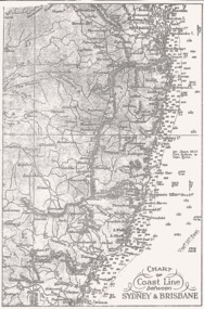 Queenscliffe Maritime Museum
Map - B & W coastal map between Sydney & Brisbane, Australia, Coastal map, Queensland, between Whitsunday Island & Hervey Bay, Before donation in 1987
Australian coastal mapsAustralian coastal mapsCoastal 'soundings' map between Sydney & Brisbane, from an unknown book, pre-1987.Reverse " NIL "old maps of australian coast -
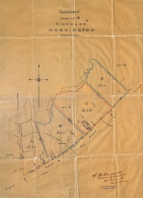 Ringwood and District Historical Society
Plan, Subdivision of Crown Lot 19, Ringwood, Victoria - circa 1915
Surveyor's map on wax paperSubdivision map includes Mullum Creek, Government Road to Anderson's Creek, later Warrandyte Road, Government Road to Lillydale, later Whitehorse Road, small creek bridge, later Sandy Creek at Ringwood Lake. Buildings marked include Roman Catholic Church, O.J. Pratt's House and Pratt's butcher shop (photos attached). Map by A.B. Bruford & Co., Licensed Surveyor, 47 Queen Street, Melbourne. -
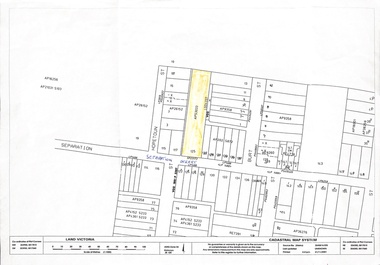 Whitehorse Historical Society Inc.
Map, 125 Separation Street, Northcote. Cadastral Map, 21/11/2001
A3 Cadastral Map of 125 Separation Street, Northcote August Schwerkolt purchased this property on 01/08/1853 where he lived and farmed the land, eventually purchasing the Mitcham property as well in 1861An A3 cadastral mapschwerkolt august -
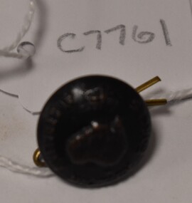
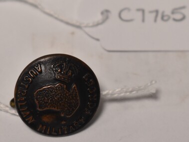 Tatura Irrigation & Wartime Camps Museum
Button, K C Luke Pty Ltd
Issued to Sister Kathleen Heaphy of Australian Army Nursing service. Sister Heaphy was attached, for part of her service, to 28 Camp Hospital Internment camp 1.round brass button with a metal shank. Crown and map of Australia and wording around the circumference. A split pin is through the shank.Australian Military Forces A crown and map of Australia K. C. Luke Pty Ltd Melbourneaustralian army nursing service, sister kathleen heaphy, 28 camp hospital internment camp 1 -
 Tatura Irrigation & Wartime Camps Museum
Button, K C Luke Pty Ltd
Issued to Sister Kathleen Heaphy of Australian Army Nursing service. Sister Heaphy was attached, for part of her service, to 28 Camp Hospital Internment camp 1.round brass button with a metal shank. Crown and map of Australia and wording around the circumference. A split pin is through the shanks.Australian Military Forces A crown and map of Australia K. C Luke Pty Ltd Melbaustralian army nursing service, sister kathleen heaphy, 28 camp hospital internment camp 1, brass buttons -
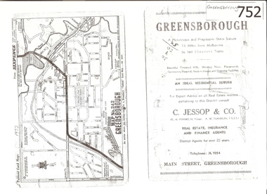 Greensborough Historical Society
Map, Broadbent's, Greensborough, 1953_
This road map was a part of a Broadbent's Melbourne suburban directory from 1953.It shows the lay out of Greensborough's streets in 1953.It also shows some different street names to those used today. It also features a C Jessop & Co. Real estate advertisementA 1 page photocopy of a road map of Greensborough from 1953.Nilgreensborough, c jessop, broadbents, map no 242, road maps, 1953 -
 Falls Creek Historical Society
Map - Falls Creek mid 1970s
A site map produced for the Falls Creek Tourist Area Management CommitteeThis map is significant because it documents an important stage in the development of Falls Creek, Victoria.A framed and mounted site map of Falls Creek mid 1970sfalls creek tourist area management committee, falls creek tourist area, falls creek 1970s -
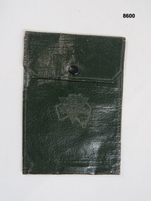 Bendigo Military Museum
Equipment - WALLET, Unknown
Green waterproof wallet, two inside pockets, brass press clip broken. A triangle shape over the map of Australia on front with inscription.On triangle & map of Australia, "Talk clean, live clean, fight clean, play the game."passchendaele barracks trust, wallet, waterproof, equipment -
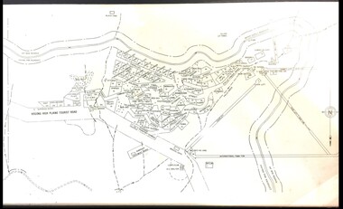
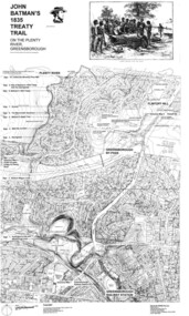 Greensborough Historical Society
Map, Dennis Ward, John Batman's 1835 Treaty Trail on the Plenty River, 2010_
Map of the Plenty River through Greensborough and surrounding areas, annotated with historic places. Prepared by Dennis Ward, this map shows places of interest with historic markers for a proposed Heritage Trail along the Plenty. This was a joint project of Dennis Ward, Rotary Greensborough and Nillumbik Historical Society.This map shows many places of interest along the Plenty River. Large laminated map, including land subdivisions and street names.plenty river heritage trail -
 Ballarat Tramway Museum
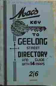
Map, A W Hedley, McHardy's Publications, "Mac's key to Geelong Street Directory", late 1930s
... maps ...Geelong Street Directory - "Mac's Key to Geelong", 14 maps, giving a directory of streets, suburb listing and abbreviations, Municipal and Public offices of Government departments and a list of Justices of the Peace. Shows the tram routes and rail lines. Has many advertisements for Geelong businesses or products. Possibly late 1930s as map 1 does not show the line to the Beach.Yields information about Geelong suburbs and businesses, late 1930sPrinted booklet - 40 pages + card cover, centre stapled.On front cover "To be retained in D/S's Office" in ink and on page 1 "Ex B. Weedon with thanks"tramways, geelong, maps -
 Victorian Aboriginal Corporation for Languages
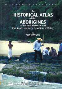
Book, Sue Wesson, An historical atlas of the Aborigines of Eastern Victoria and Far South-eastern New South Wales, 2000
An extremely detailed atlas of tribes, clans, and languages in eastern Victoria and south-eastern New South Wales. Includes maps, census information about the numbers and makeup of these clans in historical records, meanings and comparative spellings of all known named tribes and clans.maps, b&w photographs, colour photographs, tables -
 Melbourne Tram Museum
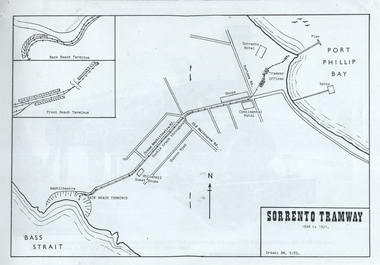
Map, "Sorrento Tramway", May 1983
... maps ...Set of 9 sheets containing a map of the "Sorrento Tramway", and 8 sheets of photographs including one of the horse tram from the collections of Norm Wadeson, A R Lyell, A Winzenried collections. The Map is dated 5/1983 by SM.Yields information the Sorrento tramway line and some of its operations.Set of 9 A4 sheets, printed or copied from a publication.tramways, maps, sorrento, horse tram -
 Phillip Island and District Historical Society Inc.
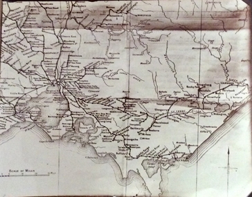
Photograph, Rail Lines of Victoria, Early to mid 20th century
Map showing extensive railway network in Victoria in early C20th.Sepia photo of map of Victoria showing rivers and railway lines and stations.Names of towns, rivers, bays etcsepia photograph, rail transport, victoria, map -
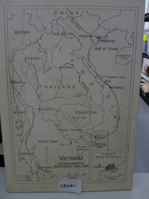 National Vietnam Veterans Museum (NVVM)
Map, Vietnam in Continental Southeast Asia 1965, 1965
Mounted black and white map of Southeast Asia with country borders and major cities marked. There is a highlight of Phuc Tuy Province in the lower righthand cornerCountries, cities and gulfs anotated map title - Vietnam in Continental Southeast Asia 1965map, phuc tuy -
 Greensborough Historical Society
Pamphlet - Directory, Greensborough Plaza directories, 2000s
Various shopping directories for Greensborough Plaza: 2001, 2007, and 2 undated pamphlets. Includes centre map.4 advertising pamphlets. Folded with colour illustrations and map.greensborough plaza, advertising images -
Stawell Historical Society Inc
Map, Stawell Gold Mines, Stawell Township 1995, 1995
Map shows details of mining activity Stockpiles, Tracks, Plant, Dams,, Waste, Tailing Dams, IronbarksPlain Printed Map in Black & White with details of MiningStawell Gold Mines Pty Ltdmining -
 Ballan Shire Historical Society
Map - Map. Moorarbool East and West, Country Lands in the Parishes of Moorarbool East and Moorarbool West. Counties of Bourke and Grant
This is a map of "Country Lands" around the Werribee River, north of Ballan in the Counties of Bourke and Grant.A relatively small map, paper on a material backing. Shows topographical features, roads and property divisions. Scale of forty chains to one inch. The map is dated March 31st, 1859.There is a small inscription under the chain scale that reads "No 58/364 John Phillips ? Survey 1st August 1858". The name Dugald McPherson is hand written on one of the blocks of land.moorarbool west, moorarbool east, dugald mcpherson, county of bourke, county of grant, werribee river, ballan -
 Ballan Shire Historical Society
Map - Map. Korweinguboora, Department of Lands and Survey, Korweinguboora. Counties of Talbot and Grant
A map of the Korweinguboora area showing roads, forests, railway lines and properties with the owners names.The inclusion of the names of landowners is of significance and value to historians.A map of the Korweinguboora area showing land subdivisions and names of owners and other physical features. There is a scale in chains. No date is certain but it could be 1902. The map has been repaired with sellotape.There are various pencil annotations but the are difficult to read.talbot, moorarbool west, wombat, bullarto, korweinguboora, moorarbool east, dean, wombat state forest, barkstead -
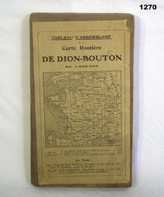 Bendigo Military Museum
Accessory - MAP, 1914-1919
The map belonged to Jack Grinton No 1043, 38th Batt AIF. Part of the Grinton collection which included hundreds of negatives and developed photos that he took during the War. Refer Cat No 1280 for service details. Refer 1317P, 1320P.Map of a small sector of France. The coloured map is on a grey canvas backing. Map covers an area from the coast to Amiens to St Quentin-north to south from Bethune-Arras-Richecourt. The map has 32 panels and folds down into one."Carte Routiere De Dion Bouton Amiens"docuents-maps-france, military history -
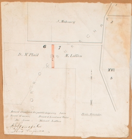 Bacchus Marsh & District Historical Society
Map, Land required for a public highway near Rowsley, Victoria. Circa 1880s
This map indicates portions of land in the Parish of Gorrockburkchap near Rowsley which was required for construction of a road. The land required was leased to a Michael Laffan. Other blocks of land nearby owned or leased by D. McPhail and J. Mahoney are also indicated on the map. The date of the map is not known. However newspaper reports in the Bacchus Marsh Express on the 18 March 1882, page 3, column 3 mention land occupied by McPhail and Laffan near Rowsley in connection to the construction of a public road.Single page map showing land occupied by farmers D. McPhail and Michael Laffan which was required for a public highway. Scale 6 chains to inch. Part of a set of maps which are pasted into a bound volume containing 76 maps or plans in total. High resolution digital image stored on BMDHS computer network. Signed by Shire Engineer, W.E. Standfieldrowsley victoria maps -
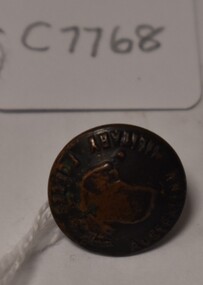
 Tatura Irrigation & Wartime Camps Museum
Button, P J King Pty Ltd
Issued to Sister Kathleen Heaphy of Australian Army Nursing service. Sister Heaphy was attached, for part of her service, to 28 Camp Hospital Internment camp 1.1 round brass button with a metal shank crown and map of Australia and wording around the circumference. A split pin is through the shank.Australian Military Forces and a crown and map of Australia. P. J. King Pty Ltd Melbourneaustralian army nursing service, sister kathleen heaphy, 28 camp hospital internment camp 1, brass buttons -
Clunes Museum
Map
Map recovered from Estate sale at 31 Service Street, Clunes (former Fraser family residence and originally Shrigley residence)This item was donated by Catherine Jenkins/James Curzon from the Estate sale of Mr. Albert FraserMap of Clunes township printed on buff paperPrinted on front: In black ink, "Shire of Talbot and Clunes, Shire Eng. (name Illegible Boyd?) -/10/74map, clunes township, mr albert fraser, 31 service street -
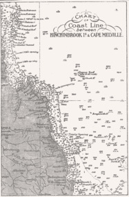 Queenscliffe Maritime Museum
Map - B & W coastal map of Hinchinbrook Island to Cape Melville in Queensland, Coastal map Queensland Hinchinbrook Is to Cape Melville, Before donation in 1987
Australian coastal mapsAustralian coastal mapsMap from unknown book of Queensland coast Hinchinbrook Island to Cape Melville, pre 1987Reverse " NIL "old maps of australian coast -
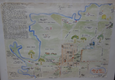 Kew Historical Society Inc
Map, Elizabeth Mackie, Kew 1875-1880s, c. 1985
Elizabeth Mackie was a member of the Kew Historical Society and a resident of 1 Molesworth Street. She researched and wrote the booklet 'Artists of Kew' and initiated research into authors with a connection to Kew. One of the most important maps of Kew in the KHS Collection is 'Back to Kew' created by Jesse Dannock. This water damaged map was in many places unreadable, and this re-creation by Elizabeth Mackie only included part of the original text. It was also liberally added to with pictorial symbols.A reinterpretation of the Back to Kew 1875 map created by Jesse Dannock in circa 1931. This hand-drawn map was created by Elizabeth Mackie in the 1980s.elizabeth mackie, plan of kew, maps -- kew (vic.), jesse dannock