Showing 17450 items
matching bay-bridge
-
 Ringwood and District Historical Society
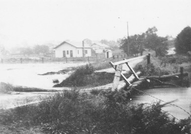
Photograph, Mullum Creek in flood, Ringwood. Adelaide St. Bridge to Reynolds Ave washed away, 1931
Catalogue card reads, "Mullum Creek in flood. Adelaide St. Bridge to Reynolds Ave washed away, 1931". Typed below photograph, "Adelaide St. bridge, to Reynolds Ave washed out in 1931 (Bridge not replaced). 1934?" -
 Tarnagulla History Archive
Photograph, Businesses at Laanecoorie Bridge, circa 1920
Donald Clark Collection. A monochrome photograph depicting businesses at Laanecoorie Bridge, including the Laanecoorie Bridge Hotel and R.J. Davis General Store (both now private residences). Copy photograph. -
 Greensborough Historical Society
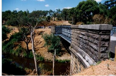
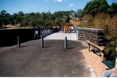
Photograph - Digital Image, Anne Paul, Opening of restored Old Lower Plenty Bridge 2001 - side view of bridge, 14/03/2001
The opening of the restored Old Lower Plenty Bridge, opened on 14/03/2001 by the Minister for Environment and Conservation Sherryl Garbutt MLA and Mayor of Banyule Cr Dale Peters. The project was jointly funded by Banyule Council and Parks Victoria. The restored bridge is the oldest remaining bridge in the former Shire of Eltham and forms part of the Plenty River Trail. This photograph shows the bridge from the side elevation, showing the bluestone and iron construction.Digital copy of colour photographlower plenty, lower plenty bridge, sherryl garbutt, dale peters, banyule council, parks victoria -
 Orbost & District Historical Society
black and white photograph, first half 20th century
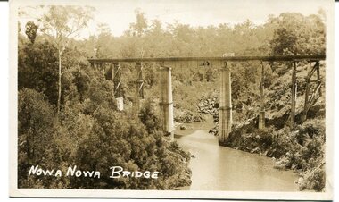
This appears to be the Boggy Creek bridge and to have been taken at Nowa Nowa. The Boggy Creek Bridge was built in 1916 as part of the Bairnsdale to Orbost extension to the main Gippsland Railway, and is situated in the middle of the township of Nowa Nowa, crossing a steep-sided and well-timbered creek-valley. This section of the line closed in 1987.This bridge plays a major part in the identity and history of the town of Nowa Nowa, since Boggy Creek’s steep sided valley divides the township into two components. It is part of the East Gippsland Railway line.A black / white photograph / postcard of a tall railway bridge, with concrete pylons in the centre,There is a creek below.on front - bottom left - " NOWA NOWA BRIDGE"boggy-creek-railway-bridge nowa-nowa railway-bridge east-gippsland-railway orbost-bairnsdale-railway -
 Greensborough Historical Society
Photograph - Digital Image, Anne Paul, Opening of restored Old Lower Plenty Bridge 2001 - bridge and community, 14/03/2001
The opening of the restored Old Lower Plenty Bridge, opened on 14/03/2001 by the Minister for Environment and Conservation Sherryl Garbutt MLA and Mayor of Banyule Cr Dale Peters. The project was jointly funded by Banyule Council and Parks Victoria. The restored bridge is the oldest remaining bridge in the former Shire of Eltham and forms part of the Plenty River Trail. This photograph shows the bridge area ready for the opening ceremony and the assembled community members attending the function.Digital copy of colour photographlower plenty, lower plenty bridge, sherryl garbutt, dale peters, banyule council, parks victoria -
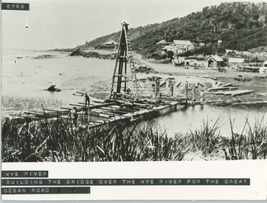 Lorne Historical Society
Photograph, Building of the bridge at Wye River, on G.O.R
Photograph showing construction of the bridge at Wye River on the G.O.R.g.o.r; wye-river; g.o.r; bridge-construction; -
 Ringwood and District Historical Society
Envelope, Packet: History of Nelson Hill (Burnt Bridge) Post Office, Ringwood
History of Nelson Hill (Burnt Bridge) Post Office -
 Federation University Historical Collection
Technical Drawing, Drawing of a Bridge Structure, 1924
Pencil on paper student's technical drawing of a bridge structure technical drawing, engineering drawing, g. murrowood, drawing of a bridge structure, bridge -
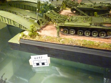 National Vietnam Veterans Museum (NVVM)
Model - Diorama, Bridge-laying Tank
Centurion Tank- Bridgelayer showing deployed bridge with crew.diorama, centurion tank, bridgelayer -
 Whitehorse Historical Society Inc.
Photograph, Deep Creek Road Bridge
Coloured photo of Deep Creek Road Bridge, 1997.deep creek road, mitcham., warren, frances -
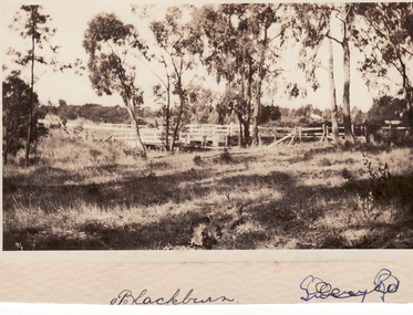 Whitehorse Historical Society Inc.
Photograph - Black and white photo, Bridge in Blackburn
Black and white photo of Bridge in Blackburn Mounted on Board.bridges, blackburn -
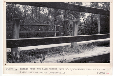
 Whitehorse Historical Society Inc.
Photograph, Lake Road Bridge, C1962
Black and white photo of bridge, Lake Road, Blackburnlake road blackburn, lake road bridge blackburn -
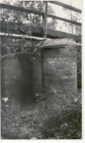
 Whitehorse Historical Society Inc.
Photograph, Bridge Over Lake Road
Black and white photo of bridge, Lake Road, Blackburnlake road bridge blackburn, lake road, blackburn -
 Ballarat Heritage Services
Photograph, Bridge
Associated with Carisbrook.A new concrete bridge over a creek near Carisbrook.em22, bridge, landscape, river, carisbrook -
 Ballarat Heritage Services
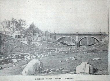
Photograph, Bridge over the Merri Creek, c1914, c1914
Bridge over the Merri Creek from the Argus Newspapermerri creek, fitzroy, bridge -
 Ballarat Heritage Services
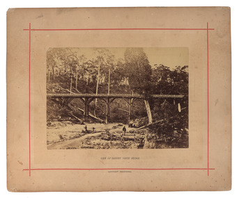
Photograph - Mounted photograph, Nicholas J. Caire, View of Sailors' Creek Bridge, c1877
Original photograph of a bridge at Sailors' Creek, near Daylesford. daylesford, bridge, nicholas caire, sailors' creek -
 Melbourne Tram Museum
Photograph - Digital Image, Kevin O'Reilly, series of three images of the Hawthorn Bridge over the Yarra, c1930, c1930's
Image from CD (Compact Diskette for use in computers) - see Reg Item 135. A series of three images of the Hawthorn Bridge over the Yarra, c1930, during the era with problems with the bridge. See separate article for more details. Richmond 6, Richmond, Richmond 3 on the CD as original files. .1 - Looking from the south west, at the Hawthorn bridge with the temporary wooden bridge being constructed on the south side. Has the cable tram depot in the photo and part of the Burnley racing course. Temporary track on the north side of the steel bridge and crossings can be seen. .2 - Looking along Bridge Road to the east with Hawthorn Bridge in the middle of the photograph. Shows the industrial and residential areas, Hawthorn Railway Station and part of the Burnley Race course, the cable tram depot building. W class tram in Church St Hawthorn and W class tram crossing the bridge on the north side temporary track. Note the cable tram used as a shelter on the north east corner of the bridge. .3 - Looking south along River St towards Bridge Road, with the Yarra River and Hawthorn Bridge on the left side of the photograph. Shows the industry in the area at the time, wool and skin Merchants, north side of the cable depot, housing and the outlook to the river!trams, tramways, hawthorn, yarra river, burnley, richmond, hawthorn bridge -
 Lorne Historical Society
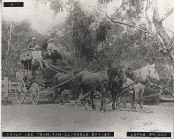
Photograph - Black and white photograph, mounted, Coach & Team, Sam Clissold driver. Lorne Bridge
Print mounted on board showing coach crossing Erskine RiverCoach & Team - Sam Clissold driver. Lorne Bridgebridge, coach, sam clissold, clissold, lorne bridge, horse driven, 1617, erskine, coach-driver -
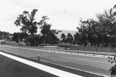
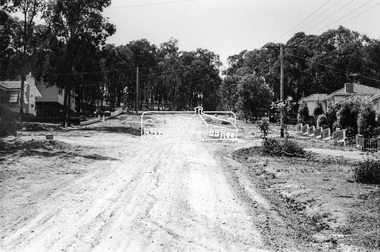
 Ringwood and District Historical Society
Photograph, Ringwood foot bridge, west side of Warrandyte Rd. 1919
Written on back of card, "Ringwood foot bridge, 1919". -
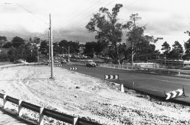
 Ringwood and District Historical Society
Photograph, Warrandyte Rd. bridge, Ringwood. Sept. 1987
Written on back of photograph, "13.9.87. Warrandyte Rd. bridge". -
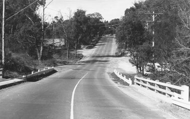
 Ringwood and District Historical Society
Photograph, Warrandyte Rd. bridge, Ringwood. April 1987
Written on back of photograph, "8.4.87. Warrandyte Rd. bridge". -
 Ringwood and District Historical Society
Photograph, Two photos taken at Deep Creek Road bridge c.1973
Typed below photograph, "Deep Creek Road bridge..." -
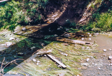 Eltham District Historical Society Inc
Photograph, Cross beam from old timber Main Road bridge over the Diamond Creek, 1992, 1992
Two colour photographs of old cross beam from original Main Road trestle bridge lying in creek bed. It is downstream from the current re-structured bridgebridges, diamond creek, main road, eltham south -
 Eltham District Historical Society Inc
Photograph, Bridge Street, Eltham, c. Sep. 1966
Last house on right is No. 122. The three houses on right remain relatively original in present time, the two visible houses on left have been substantially altered or replaced. Bridge Street ended at this point but has since been further extended eastBlack and white photographic printOriginally located in a Filmpro King Size Prints processing envelope $3.01 Shire of Eltham 9/9/66 and noted as Calrossie Ave area and crossed out Eltham-Yarra Glen Road, Bridge Street to Elsa Court existing conditions mid 1967eltham, infrastructure, road construction, roads, bridge street -
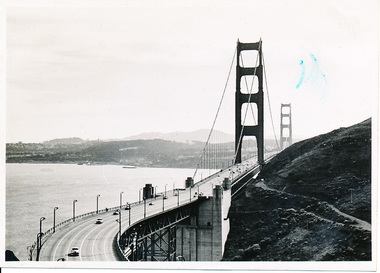 Mission to Seafarers Victoria
Photograph - Photograph, Black and white
This photograph is part of series depicting Allan Quinn's travels through San Francisco in 1949. This photograph shows the Golden Gate Bride and the San Francisco Bay.This is a photograph from the Allan Charles Quinn collection which is a collection of letters and photograph depicting aspects of life at sea for a young man in the era immediately following World War II.A black and white photograph of the Golden Gate Bridge, and the San Francisco Bay, dated 9-11-49.Reverse: 9-11-49 (handwritten in blue ink) / B /K8 (upside down, handwritten in pencil).allan-quinn, photograph, san-francisco, golden-gate-bridge, 1949, allan charles quinn (1928-1990) -
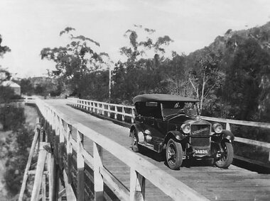
 Orbost & District Historical Society
black and white photograph, mid 1930s
This is a photograph of McKillop's Bridge probably taken just after its rebuilding. The current McKillop’s Bridge was built by the Country Roads Board in two stages between 1931-36, during which its height was raised after the original bridge superstructure was washed away in record floods of January 1934, prior to its original official opening. In its reconstructed form the original concrete abutments were turned into additional piers and the welded-steel trusses were cantilevered back over them to meet the new higher road approaches. "McKillops Bridge was Heritage listed due to its social and technological significance – the steel trusses' arc-welded construction technique was a pretty big deal in the 1930s. It was once an important route for cattlemen, who used the ford across the Snowy in the years preceding the bridge's existence"This is a pictorial record of McKillop's Bridge just after its construction.A black / white photograph of a wooden bridge across a river. At the bottom right is a man with his back to the camera. He is looking at flood debris on the bank. At the bottom left are two men near a pylon.on back - McKillops Bridgebridge-mckillop's snowy-river-bridge -
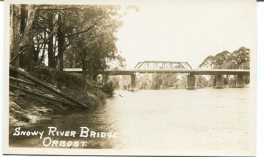 Orbost & District Historical Society
black and white photograph, first half 20th century
This is a photograph of the second Snowy River Bridge at Orbost. The section in the central span could have been built after flood damage. This bridge over the Snowy River was opened on July 4 1922. It was constructed in 1922 alongside the previous suspension bridge. Its building was a combined effort of the Victorian Railways and the Country Roads Board at a cost of 35,000 pounds. It was replaced in 1976 by the present bridge after several major floods.This bridge was replaced in 1976 after several major floods.A black / white photograph / postcard of a bridge over a river. It has what looks like a bo girder in the central section. On the left is the river bank.on front bottom left - "SNOWY RIVER BRIDGE"orbost snowy-river-bridge transport-bridge -
Lakes Entrance Regional Historical Society (operating as Lakes Entrance History Centre & Museum)
Postcard, H D Bulmer, 1950 c
Also a cut down colour photograph of second humpy bridge to Bullock Island donated by M Fish number 04208.1 size 3 x 13 cm|Also two black and white photographs numbers 04208.2 and 04208.3 in SparesColour tinted postcard of Bullock Island and first traffic bridge. Island has no development.North Arm bridge and Princes Highway in foreground, New Works area across Cunninghame Arm in distance Lakes Entrance VictoriaBullock Island and Bridge Lakes Entranceroads and streets, waterways -
 Stawell Historical Society Inc
Photograph - Stanley Steamer of Old Delley's Bridge, Stanley Steamer on Old Delleys Bridge c1922, C 1926
Transport Halls Gap50 M North of New Curved Bridge c 1926 -
 Whitehorse Historical Society Inc.
Photograph, Railway Bridge, Brunswick Road, Heatherdale - Now Cochrane Street - runs through to Orient Avenue, C.1958
Black and white photo of Railway Bridge, Brunswick Road, Heatherdale.o'rourke, l.