Showing 734 items
matching building blocks
-
 Kew Historical Society Inc
Map, Robert Russell, Map Shewing the Site of Melbourne and the Position of the Huts & Buildings Previous to the Foundation of the Township by Sir Richard Bourke in 1837
Map shows the first layout of Melbourne by Government surveyor Robert Russell, who accompanied Governor Richard Bourke in 1837. The surveyed blocks extend from present-day Flinders Street to Lonsdale Street, and Spring Street to Spencer Street, with extensive vacant land west to a salt lake (afterwards Batman's Swamp, later drained), north beyond Flagstaff Hill and south towards South Melbourne. Vegetation coverage is indicated, and tracks and existing buildings and cultivated land are shown.Printed map was created by Day & Haghe, Lithographers to the Queen, sometime after 1838, when the company received its Royal appointment. Copies of the 1837 map exist in several major map collections in Australia; most are uncoloured. This particular map is the earliest in the Kew Historical Society's map collection. It is a nationally significant artefact. Black and white lithographed map hand-coloured in blue and yellow gouache of the town of Melbourne in 1837. In contrast to the original lithograph, the river and the township blocks are coloured blue and yellow. A similar, partly coloured copy is in the collection of the University of Melbourne.maps - melbourne - 1830s, governor sir richard bourke, robert russell - surveyor, cartography -
 Kew Historical Society Inc
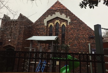
Photograph - Photographs, Former Baptist Church, Woodlands Avenue, Kew East, 2018, 2018
The former Baptist Church, at 8-12 Woodlands Avenue, Kew East, was nominated by the Society for protection as part of the Kew East Heritage Gap Study. W D Vaughan in his 'Kew's Civic History' (1960 writes that: "With the development of East Kew, local Baptists considered the establishment of a church was necessary. A block of land was purchased in Woodlands Avenue and the foundation stone of a new church was laid on August 8, 1931. A fine Sunday school has since been erected, and special emphasis has been given to providing activities for the young people of the church"Three colour photographs of the former Baptist Church in Woodlands Avenue, Kew East. The photographs are of the front and side of the clinker brick building. One of the photographs shows the foundation stone, laid by AH Lewis Esq, 8 August 1931.churches - kew (vic), baptist church - woodlands avenue - kew (vic) -
 Kew Historical Society Inc
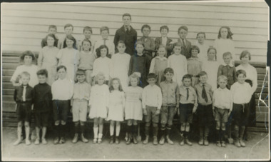
Photograph - Kew East State School
State School No. 3161 was originally situated between High Street (then Bulleen Road) and Kilby Road adjacent to Burke Road and was officially opened on 25th April 1892 with Mr Roland Gray as its Headmaster. With more people moving into the district, the School was moved in 1905 to Strathalbyn Street. (This site was to became the Kew East Bowling Club, and is now a Kindergarten.) 1929 saw the erection of the brick Infant School adjacent to the main building. In subsequent years many other buildings were added, including a weatherboard ‘Rural’ school, a brick library, an administration block, several portables, and a Community Music Centre and shelter sheds, culminating in the opening in March 2011 of the Commonwealth funded new Music/Sports Complex. At one time it was called Kew East Central School and included years 7 & 8. When Kew High School started, the high school students were accommodated there whilst their buildings were being completed.Undated, original print positive of a co-educational class of students at Kew East State School. Margery Canham (nee Nickell) and the teacher, Miss Sybil North, are named in an inscription on the reverse of the mount. "Kew East Primary School. Miss Sybil North teacher. Margery Canham (nee Nickell) 2nd row, 3rd rightkew east primary school, margery canham, margery nickell, elizabeth angel, kew east state school -
 Kew Historical Society Inc
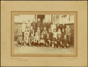
Photograph - Kew East Country School, 1919
State School No. 3161 was originally situated between High Street (then Bulleen Road) and Kilby Road adjacent to Burke Road and was officially opened on 25th April 1892 with Mr Roland Gray as its Headmaster. With more people moving into the district, the School was moved in 1905 to Strathalbyn Street. (This site was to became the Kew East Bowling Club, and is now a Kindergarten.) 1929 saw the erection of the brick Infant School adjacent to the main building. In subsequent years many other buildings were added, including a weatherboard ‘Rural’ school, a brick library, an administration block, several portables, and a Community Music Centre and shelter sheds, culminating in the opening in March 2011 of the Commonwealth funded new Music/Sports Complex. At one time it was called Kew East Central School and included years 7 & 8. When Kew High School started, the high school students were accommodated there whilst their buildings were being completed.Original print positive, mounted on board of a co-educational class of students at Kew East 'Country School'. Howard Nickell is identified in an inscription on the reverse of the mount. The Age newspaper on 6 March 1906 included in News of the Day that: "At a meeting of the Executive Council yesterday it was decided to proclaim the following State schools as training schools under the provisions of the Teachers' Act: Brunswick 1213; Queensberry-street, Carlton 2365; Kew East 3161; and Queensberry-street, North Melbourne 307. These schools have been specially selected and staffed in order that teachers in training and junior teachers may study the methods of the best teachers in special kinds of work. The infant class is the special feature at Brunswick, while Kew East will be a model of the methods of a country school. The schools at Queensberry-street, North Carlton and North Melbourne, are to be more especially connected with the training college."Obverse: Written on held chalk board: "Kew East 3161 / Country School / 1919". Reverse: "Howard Nickell, 2nd row, left - end of row"kew east primary school, margery canham, margery nickell, elizabeth angel, kew east state school, kew east country school -
 Kew Historical Society Inc
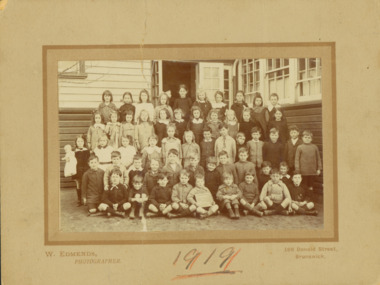
Photograph - Kew East State School, 1919
State School No. 3161 was originally situated between High Street (then Bulleen Road) and Kilby Road adjacent to Burke Road and was officially opened on 25th April 1892 with Mr Roland Gray as its Headmaster. With more people moving into the district, the School was moved in 1905 to Strathalbyn Street. (This site was to became the Kew East Bowling Club, and is now a Kindergarten.) 1929 saw the erection of the brick Infant School adjacent to the main building. In subsequent years many other buildings were added, including a weatherboard ‘Rural’ school, a brick library, an administration block, several portables, and a Community Music Centre and shelter sheds, culminating in the opening in March 2011 of the Commonwealth funded new Music/Sports Complex. At one time it was called Kew East Central School and included years 7 & 8. When Kew High School started, the high school students were accommodated there whilst their buildings were being completed.Original print positive, mounted on board of a co-educational class of students at Kew East 'Country School'. Margery Canham (nee Nickell) is identified in an inscription on the reverse of the mount. The Age newspaper on 6 March 1906 included in News of the Day that: "At a meeting of the Executive Council yesterday it was decided to proclaim the following State schools as training schools under the provisions of the Teachers' Act: Brunswick 1213; Queensberry-street, Carlton 2365; Kew East 3161; and Queensberry-street, North Melbourne 307. These schools have been specially selected and staffed in order that teachers in training and junior teachers may study the methods of the best teachers in special kinds of work. The infant class is the special feature at Brunswick, while Kew East will be a model of the methods of a country school. The schools at Queensberry-street, North Carlton and North Melbourne, are to be more especially connected with the training college."Obverse: Written on held chalk board: "Kew East 3161 / ? Grades / 1919". Reverse: "Margery Nickell, 4th row, back right"kew east primary school, margery canham, margery nickell, elizabeth angel, kew east state school, kew east country school -
 Kew Historical Society Inc
Photograph - Kew East Primary School, 1919
State School No. 3161 was originally situated between High Street (then Bulleen Road) and Kilby Road adjacent to Burke Road and was officially opened on 25th April 1892 with Mr Roland Gray as its Headmaster. With more people moving into the district, the School was moved in 1905 to Strathalbyn Street. (This site was to became the Kew East Bowling Club, and is now a Kindergarten.) 1929 saw the erection of the brick Infant School adjacent to the main building. In subsequent years many other buildings were added, including a weatherboard ‘Rural’ school, a brick library, an administration block, several portables, and a Community Music Centre and shelter sheds, culminating in the opening in March 2011 of the Commonwealth funded new Music/Sports Complex. At one time it was called Kew East Central School and included years 7 & 8. When Kew High School started, the high school students were accommodated there whilst their buildings were being completed.Original print positive, mounted on board of a co-educational class of students at Kew East 'Country School'. The Age newspaper on 6 March 1906 included in News of the Day that: "At a meeting of the Executive Council yesterday it was decided to proclaim the following State schools as training schools under the provisions of the Teachers' Act: Brunswick 1213; Queensberry-street, Carlton 2365; Kew East 3161; and Queensberry-street, North Melbourne 307. These schools have been specially selected and staffed in order that teachers in training and junior teachers may study the methods of the best teachers in special kinds of work. The infant class is the special feature at Brunswick, while Kew East will be a model of the methods of a country school. The schools at Queensberry-street, North Carlton and North Melbourne, are to be more especially connected with the training college."Obverse: Written on chalk slate - "Kew East / 3161 / Country School /19??"kew east primary school, margery canham, margery nickell, elizabeth angel, kew east state school, kew east country school, erik nickell -
 Kew Historical Society Inc
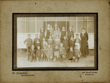
Photograph - Kew East State School
State School No. 3161 was originally situated between High Street (then Bulleen Road) and Kilby Road adjacent to Burke Road and was officially opened on 25th April 1892 with Mr Roland Gray as its Headmaster. With more people moving into the district, the School was moved in 1905 to Strathalbyn Street. (This site was to became the Kew East Bowling Club, and is now a Kindergarten.) 1929 saw the erection of the brick Infant School adjacent to the main building. In subsequent years many other buildings were added, including a weatherboard ‘Rural’ school, a brick library, an administration block, several portables, and a Community Music Centre and shelter sheds, culminating in the opening in March 2011 of the Commonwealth funded new Music/Sports Complex. At one time it was called Kew East Central School and included years 7 & 8. When Kew High School started, the high school students were accommodated there whilst their buildings were being completed.Original print positive of a co-educational class of students at Kew East State School. Howard Nickell is identified in an inscription on the reverse of the mount. The Age newspaper on 6 March 1906 included in News of the Day that: "At a meeting of the Executive Council yesterday it was decided to proclaim the following State schools as training schools under the provisions of the Teachers' Act: Brunswick 1213; Queensberry-street, Carlton 2365; Kew East 3161; and Queensberry-street, North Melbourne 307. These schools have been specially selected and staffed in order that teachers in training and junior teachers may study the methods of the best teachers in special kinds of work. The infant class is the special feature at Brunswick, while Kew East will be a model of the methods of a country school. The schools at Queensberry-street, North Carlton and North Melbourne, are to be more especially connected with the training college."Reverse: "Howard Nickell. Back Row. Second right."kew east primary school, elizabeth angel, kew east state school, howard nickell -
 Kew Historical Society Inc
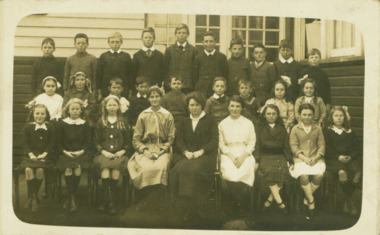
Photograph - Kew East State School
State School No. 3161 was originally situated between High Street (then Bulleen Road) and Kilby Road adjacent to Burke Road and was officially opened on 25th April 1892 with Mr Roland Gray as its Headmaster. With more people moving into the district, the School was moved in 1905 to Strathalbyn Street. (This site was to became the Kew East Bowling Club, and is now a Kindergarten.) 1929 saw the erection of the brick Infant School adjacent to the main building. In subsequent years many other buildings were added, including a weatherboard ‘Rural’ school, a brick library, an administration block, several portables, and a Community Music Centre and shelter sheds, culminating in the opening in March 2011 of the Commonwealth funded new Music/Sports Complex. At one time it was called Kew East Central School and included years 7 & 8. When Kew High School started, the high school students were accommodated there whilst their buildings were being completed.Original print positive, mounted on board of a co-educational class of students at Kew East State School. Jean Nickell is identified in an inscription on the reverse of the mount. The Age newspaper on 6 March 1906 included in News of the Day that: "At a meeting of the Executive Council yesterday it was decided to proclaim the following State schools as training schools under the provisions of the Teachers' Act: Brunswick 1213; Queensberry-street, Carlton 2365; Kew East 3161; and Queensberry-street, North Melbourne 307. These schools have been specially selected and staffed in order that teachers in training and junior teachers may study the methods of the best teachers in special kinds of work. The infant class is the special feature at Brunswick, while Kew East will be a model of the methods of a country school. The schools at Queensberry-street, North Carlton and North Melbourne, are to be more especially connected with the training college."Obverse on chalkboard: "Kew East / 3161 / 1 & 2 Grades" / Reverse: "Jean Nickell. Back row 6th left"kew east primary school, elizabeth angel, kew east state school, jean nickell, w edmends -
 Kew Historical Society Inc
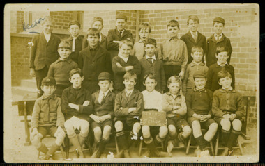
Photograph - Kew East State School, 1926
State School No. 3161 was originally situated between High Street (then Bulleen Road) and Kilby Road adjacent to Burke Road and was officially opened on 25th April 1892 with Mr Roland Gray as its Headmaster. With more people moving into the district, the School was moved in 1905 to Strathalbyn Street. (This site was to became the Kew East Bowling Club, and is now a Kindergarten.) 1929 saw the erection of the brick Infant School adjacent to the main building. In subsequent years many other buildings were added, including a weatherboard ‘Rural’ school, a brick library, an administration block, several portables, and a Community Music Centre and shelter sheds, culminating in the opening in March 2011 of the Commonwealth funded new Music/Sports Complex. At one time it was called Kew East Central School and included years 7 & 8. When Kew High School started, the high school students were accommodated there whilst their buildings were being completed.Original print positive of class of boys at Kew East State School. Hector Canham is identified in an inscription on the reverse of the mount. The Age newspaper on 6 March 1906 included in News of the Day that: "At a meeting of the Executive Council yesterday it was decided to proclaim the following State schools as training schools under the provisions of the Teachers' Act: Brunswick 1213; Queensberry-street, Carlton 2365; Kew East 3161; and Queensberry-street, North Melbourne 307. These schools have been specially selected and staffed in order that teachers in training and junior teachers may study the methods of the best teachers in special kinds of work. The infant class is the special feature at Brunswick, while Kew East will be a model of the methods of a country school. The schools at Queensberry-street, North Carlton and North Melbourne, are to be more especially connected with the training college."Obverse : "Hector [arrowed]" / Reverse: "5th Grade. Hector Canham. Back row left."kew east primary school, elizabeth angel, kew east state school, hector canham -
 Kew Historical Society Inc
Photograph - Kew East State School
State School No. 3161 was originally situated between High Street (then Bulleen Road) and Kilby Road adjacent to Burke Road and was officially opened on 25th April 1892 with Mr Roland Gray as its Headmaster. With more people moving into the district, the School was moved in 1905 to Strathalbyn Street. (This site was to became the Kew East Bowling Club, and is now a Kindergarten.) 1929 saw the erection of the brick Infant School adjacent to the main building. In subsequent years many other buildings were added, including a weatherboard ‘Rural’ school, a brick library, an administration block, several portables, and a Community Music Centre and shelter sheds, culminating in the opening in March 2011 of the Commonwealth funded new Music/Sports Complex. At one time it was called Kew East Central School and included years 7 & 8. When Kew High School started, the high school students were accommodated there whilst their buildings were being completed.Original print positive of a co-educational class at Kew East State School. Margaret Nickell is identified in an inscription on the reverse of the mount. The Age newspaper on 6 March 1906 included in News of the Day that: "At a meeting of the Executive Council yesterday it was decided to proclaim the following State schools as training schools under the provisions of the Teachers' Act: Brunswick 1213; Queensberry-street, Carlton 2365; Kew East 3161; and Queensberry-street, North Melbourne 307. These schools have been specially selected and staffed in order that teachers in training and junior teachers may study the methods of the best teachers in special kinds of work. The infant class is the special feature at Brunswick, while Kew East will be a model of the methods of a country school. The schools at Queensberry-street, North Carlton and North Melbourne, are to be more especially connected with the training college."Obverse : "Margery [arrowed]" / Reverse: "Margery Nickell. 2nd row left end. Teacher Miss Grey."kew east primary school, elizabeth angel, kew east state school, margery nickell -
 Kew Historical Society Inc
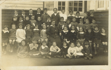
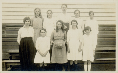
Photograph - Kew East State School, 1921-28
State School No. 3161 was originally situated between High Street (then Bulleen Road) and Kilby Road adjacent to Burke Road and was officially opened on 25th April 1892 with Mr Roland Gray as its Headmaster. With more people moving into the district, the School was moved in 1905 to Strathalbyn Street. (This site was to became the Kew East Bowling Club, and is now a Kindergarten.) 1929 saw the erection of the brick Infant School adjacent to the main building. In subsequent years many other buildings were added, including a weatherboard ‘Rural’ school, a brick library, an administration block, several portables, and a Community Music Centre and shelter sheds, culminating in the opening in March 2011 of the Commonwealth funded new Music/Sports Complex. At one time it was called Kew East Central School and included years 7 & 8. When Kew High School started, the high school students were accommodated there whilst their buildings were being completed.Original print positive of a class of girls at Kew East State School. The Age newspaper on 6 March 1906 included in News of the Day that: "At a meeting of the Executive Council yesterday it was decided to proclaim the following State schools as training schools under the provisions of the Teachers' Act: Brunswick 1213; Queensberry-street, Carlton 2365; Kew East 3161; and Queensberry-street, North Melbourne 307. These schools have been specially selected and staffed in order that teachers in training and junior teachers may study the methods of the best teachers in special kinds of work. The infant class is the special feature at Brunswick, while Kew East will be a model of the methods of a country school. The schools at Queensberry-street, North Carlton and North Melbourne, are to be more especially connected with the training college."Obverse : "East Kew 1921 [sic] / Reverse: "East Kew 1928 [sic]"kew east primary school, elizabeth angel, kew east state school -
 Kew Historical Society Inc
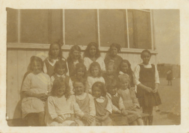
Photograph - Kew East State School
State School No. 3161 was originally situated between High Street (then Bulleen Road) and Kilby Road adjacent to Burke Road and was officially opened on 25th April 1892 with Mr Roland Gray as its Headmaster. With more people moving into the district, the School was moved in 1905 to Strathalbyn Street. (This site was to became the Kew East Bowling Club, and is now a Kindergarten.) 1929 saw the erection of the brick Infant School adjacent to the main building. In subsequent years many other buildings were added, including a weatherboard ‘Rural’ school, a brick library, an administration block, several portables, and a Community Music Centre and shelter sheds, culminating in the opening in March 2011 of the Commonwealth funded new Music/Sports Complex. At one time it was called Kew East Central School and included years 7 & 8. When Kew High School started, the high school students were accommodated there whilst their buildings were being completed.Original print positive of a class of girls at what is believed to be Kew East State School. The Age newspaper on 6 March 1906 included in News of the Day that: "At a meeting of the Executive Council yesterday it was decided to proclaim the following State schools as training schools under the provisions of the Teachers' Act: Brunswick 1213; Queensberry-street, Carlton 2365; Kew East 3161; and Queensberry-street, North Melbourne 307. These schools have been specially selected and staffed in order that teachers in training and junior teachers may study the methods of the best teachers in special kinds of work. The infant class is the special feature at Brunswick, while Kew East will be a model of the methods of a country school. The schools at Queensberry-street, North Carlton and North Melbourne, are to be more especially connected with the training college."Reverse : "Margery Nickell. 2nd row, 2nd left"kew east primary school, elizabeth angel, kew east state school, margery nickell -
 Kew Historical Society Inc
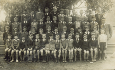
Photograph - Kew East Central School, c.1911
State School No. 3161 was originally situated between High Street (then Bulleen Road) and Kilby Road adjacent to Burke Road and was officially opened on 25th April 1892 with Mr Roland Gray as its Headmaster. With more people moving into the district, the School was moved in 1905 to Strathalbyn Street. (This site was to became the Kew East Bowling Club, and is now a Kindergarten.) 1929 saw the erection of the brick Infant School adjacent to the main building. In subsequent years many other buildings were added, including a weatherboard ‘Rural’ school, a brick library, an administration block, several portables, and a Community Music Centre and shelter sheds, culminating in the opening in March 2011 of the Commonwealth funded new Music/Sports Complex. At one time it was called Kew East Central School and included years 7 & 8. When Kew High School started, the high school students were accommodated there whilst their buildings were being completed.Original print positive of a class of boys at Kew East Central School. The Age newspaper on 6 March 1906 included in News of the Day that: "At a meeting of the Executive Council yesterday it was decided to proclaim the following State schools as training schools under the provisions of the Teachers' Act: Brunswick 1213; Queensberry-street, Carlton 2365; Kew East 3161; and Queensberry-street, North Melbourne 307. These schools have been specially selected and staffed in order that teachers in training and junior teachers may study the methods of the best teachers in special kinds of work. The infant class is the special feature at Brunswick, while Kew East will be a model of the methods of a country school. The schools at Queensberry-street, North Carlton and North Melbourne, are to be more especially connected with the training college."Obverse: on chalkboard - "East Kew Central School, Grade 5. 1911 [sic]". kew east primary school, elizabeth angel, kew east state school, kew east central school -
 Kew Historical Society Inc
Photograph - Former Kew Post Office : Cotham Road frontage, 1996
A civic campaign for new public offices developed in Kew in the 1880s. After much deliberation, the location chosen was the junction of Bulleen and Cotham Roads. The buildings were designed by George Watson and John Henry Harvey, architects within the Department of Public Works (Victoria). Building was commenced in 1887, and after one year, the buildings were opened. The Post Office was transferred to the new Commonwealth Government in 1901. The Police Station and Court House, sold by the Victorian Government to the City of Boroondara in 2007, are now a community cultural centre and performing arts venue.The buildings were listed on the Victorian Heritage Register Register (HO885) in 1991. They are historically and architecturally significant to the State of Victoria because Watson and Harvey's designs exhibit diversity in integrating civil offices, they accommodate the apex of road junctions, and they demonstrate a departure from the contemporaneously favoured High Victorian Classical to the Queen Anne style in the design of civic buildings.Panoramic photograph of the entrances from Cotham Road to the Kew Post Office, Court House and Police Station. At centre front is the public toilet block, erected in the twentieth century by the City of Kew to designs by Rowland Chipperfield.kew court house, public offices -- kew (vic), kew police station, kew post office, cotham road -- kew (vic.) -
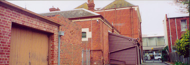 Kew Historical Society Inc
Photograph - Former Kew Police Station : outbuildings, 1996
... of the cell block. The two storey building facing High Street... Classical to the Queen Anne style in the design of civic buildings ...A civic campaign for new public offices developed in Kew in the 1880s. After much deliberation, the location chosen was the junction of Bulleen and Cotham Roads. The buildings were designed by George Watson and John Henry Harvey, architects within the Department of Public Works (Victoria). Building was commenced in 1887, and after one year, the buildings were opened. The Post Office was transferred to the new Commonwealth Government in 1901. The Police Station and Court House, sold by the Victorian Government to the City of Boroondara in 2007, are now a community cultural centre and performing arts venue.The buildings were listed on the Victorian Heritage Register Register (HO885) in 1991. They are historically and architecturally significant to the State of Victoria because Watson and Harvey's designs exhibit diversity in integrating civil offices, they accommodate the apex of road junctions, and they demonstrate a departure from the contemporaneously favoured High Victorian Classical to the Queen Anne style in the design of civic buildings.View of the rear of the former Kew Police Station in High Street, Kew. In the foreground is a red brick garage; a later addition to the building. Immediately behind that is the back of the cell block. The two storey building facing High Street was originally the Police Sergeant's residence. public offices -- kew (vic.), kew police station -
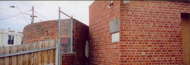 Kew Historical Society Inc
Photograph - Former Kew Court House : rear buildings facing Cotham Road, 1996
A civic campaign for new public offices developed in Kew in the 1880s. After much deliberation, the location chosen was the junction of Bulleen and Cotham Roads. The buildings were designed by George Watson and John Henry Harvey, architects within the Department of Public Works (Victoria). Building was commenced in 1887, and after one year, the buildings were opened. The Post Office was transferred to the new Commonwealth Government in 1901. The Police Station and Court House, sold by the Victorian Government to the City of Boroondara in 2007, are now a community cultural centre and performing arts venue.The buildings were listed on the Victorian Heritage Register Register (HO885) in 1991. They are historically and architecturally significant to the State of Victoria because Watson and Harvey's designs exhibit diversity in integrating civil offices, they accommodate the apex of road junctions, and they demonstrate a departure from the contemporaneously favoured High Victorian Classical to the Queen Anne style in the design of civic buildings.Original print positive photograph of two buildings on Cotham Road at the rear of the Kew Court House. On the left is a red brick public toilet block, designed by Roland Chipperfield. On the right is a red brick garage; a later addition to the Court House complex.kew court house, public offices -- kew (vic), public toilet -- kew (vic.), kew police station -
 Kew Historical Society Inc
Plan - Subdivision Plan, Jas R Mathers Son & McMillan, Macartney Estate, East Kew, c. 1925
Pru Sanderson, in her groundbreaking ‘City of Kew Urban Conservation Study : Volume 2 - Development History’ (1988), summarised the periods of urban development and subdivisions of land in Kew. The periods that she identified included 1845-1880, 1880-1893, 1893-1921, 1921-1933, 1933-1943, and Post-War Development. These periods were selected as they represented periods of rapid growth or decline in urban development. An obvious starting point for Sanderson’s groupings involved population growth and the associated economic cycles. These cycles also highlighted urban expansion onto land that was predominantly rural, although in other cases it represented the decline and breakup of large estates. A number of the plans in the Kew Historical Society’s collection can also be found in other collections, such as those of the State Library of Victoria and the Boroondara Library Service. A number are however unique to the collection.Subdivision plans are historically important documents used as evidence of the growth of suburbs in Australia. They frequently provide information about when the land was sold on which a built structure was subsequently constructed as well as evidence relating to surveyors and real estate and financial agents. The numerous subdivision plans in the Kew Historical Society's collection represent working documents, ranging from the initial sketches made in planning a subdivision to printed plans on which auctioneers or agents listed the prices for which individual lots were sold. In a number of cases, the reverse of a subdivision plan in the collection includes a photograph of a house that was also for sale by the agent. These photographs provide significant heritage information relating house design and decoration, fencing and household gardens.The Macartney Estate subdivision advertised 21 lots for sale on either side of Macartney Street (now Macartney Avenue) and Evans Road in what was then designated as East Kew. Most of the houses shown on the south side of Macartney Street then, as now, have rear entrances on Mount Street, however a number of these blocks have since been further subdivided to allow for the building of new houses on the rear of a block. Brougham Place is marked on the plan but is now called Daniell Place."C"subdivision plans - east kew, macartney estate, macartney street, mount street, evans road, brougham place -
 Kew Historical Society Inc
Plan, Melbourne & Metropolitan Board of Works : Borough of Kew : Detail Plan No.1291, 1905
The Melbourne and Metropolitan Board of Works (MMBW) plans were produced from the 1890s to the 1950s. They were crucial to the design and development of Melbourne's sewerage and drainage system. The plans, at a scale of 40 feet to 1 inch (1:480), provide a detailed historical record of Melbourne streetscapes and environmental features. Each plan covers one or two street blocks (roughly six streets), showing details of buildings, including garden layouts and ownership boundaries, and features such as laneways, drains, bridges, parks, municipal boundaries and other prominent landmarks as they existed at the time each plan was produced. (Source: State Library of Victoria). This plan forms part of a large group of MMBW plans and maps that was donated to the Society by the Mr Poulter, City Engineer of the City of Kew in 1989. Within this collection, thirty-five hand-coloured plans, backed with linen, are of statewide significance as they include annotations that provide details of construction materials used in buildings in the first decade of the 20th century as well as additional information about land ownership and usage. The copies in the Public Record Office Victoria and the State Library of Victoria are monochrome versions which do not denote building materials so that the maps in this collection are invaluable and unique tools for researchers and heritage consultants. A number of the plans are not held in the collection of the State Library of Victoria so they have the additional attribute of rarity.Original survey plan, issued by the MMBW to a contractor with responsibility for constructing sewers in the area identified on the plan within the Borough of Kew. The plan was at some stage hand-coloured, possibly by the contractor, but more likely by officers working in the Engineering Department of the Borough and later Town, then City of Kew. The hand-coloured sections of buildings on the plan were used to denote masonry or brick constructions (pink), weatherboard constructions (yellow), and public buildings (grey). A detail plan of part of Studley Park bordered by the major streets of Hodgson Street, Stevenson Street and Studley Park Road. Included on the plan are a number of significant Studley Park mansions in existence at the beginning of the 20th century. The unnamed street shown in the middle of the plan is McEvoy Street. The most important house still extant is Campion House, formerly named Dalsraith [Dalswraith] and Glendalough, owned since the 1940s by the Society of Jesus. Campion House can be seen on the corner of Hodgson and Studley Park Road. Its stables at the rear of the block have now been incorporated into a contemporary residence. An interesting feature of the plan is the 1910 annotation by Ed Seitz, professional designing engineer. Is Seitz the contractor who modified the MMBW original?melbourne and metropolitan board of works, detail plans, mmbw 1291, cartography -
 Kew Historical Society Inc
Plan, Melbourne and Metropolitan Board of Works, Melbourne & Metropolitan Board of Works : Borough of Kew : Detail Plan No.1294 & 1295, 1904
The Melbourne and Metropolitan Board of Works (MMBW) plans were produced from the 1890s to the 1950s. They were crucial to the design and development of Melbourne's sewerage and drainage system. The plans, at a scale of 40 feet to 1 inch (1:480), provide a detailed historical record of Melbourne streetscapes and environmental features. Each plan covers one or two street blocks (roughly six streets), showing details of buildings, including garden layouts and ownership boundaries, and features such as laneways, drains, bridges, parks, municipal boundaries and other prominent landmarks as they existed at the time each plan was produced. (Source: State Library of Victoria). This plan forms part of a large group of MMBW plans and maps that was donated to the Society by the Mr Poulter, City Engineer of the City of Kew in 1989. Within this collection, thirty-five hand-coloured plans, backed with linen, are of statewide significance as they include annotations that provide details of construction materials used in buildings in the first decade of the 20th century as well as additional information about land ownership and usage. The copies in the Public Record Office Victoria and the State Library of Victoria are monochrome versions which do not denote building materials so that the maps in this collection are invaluable and unique tools for researchers and heritage consultants. A number of the plans are not held in the collection of the State Library of Victoria so they have the additional attribute of rarity.Original survey plan, issued by the MMBW to a contractor with responsibility for constructing sewers in the area identified on the plan within the Borough of Kew. The plan was at some stage hand-coloured, possibly by the contractor, but more likely by officers working in the Engineering Department of the Borough and later Town, then City of Kew. The hand-coloured sections of buildings on the plan were used to denote masonry or brick constructions (pink), weatherboard constructions (yellow), and public buildings (grey).The streets and built structures in MMBW Detail Plan 1294 & 1295 were surveyed in 1903 and released to contractors in 1904. This plan is one of two in the collection where the lithographers amalgamated two separate plans. Both plans include sections of Studley Park. Dominating the south and west corners of Kew Junction are the Clifton and Kew Hotels. The Kew Hotel, owned by Patrick O’Shaughnessy was one of the oldest in Kew. MMBW plans were amended over time to take account of new subdivisions such as that which created Merrion Place. Of the four mansions shown in Studley Park Road, three remain – ‘Field Place’, the home of Frances Henty, ‘Leaghur’ and ‘Darley’. ‘Byram’ (later ‘Goathland’, then ‘Tara Hall’) was an architectural marvel. Designed in 1888 by E.G. Kilburn for the paper magnate George Ramsden, it was demolished in 1960. While an earlier sale of the southern section of Byram had created Tara Avenue in 1927, the demolition of the house in 1960 enabled the extension of Tara Avenue northward.melbourne and metropolitan board of works, detail plans, mmbw 1294, mmbw 1295, cartography -
 Kew Historical Society Inc
Plan, Melbourne & Metropolitan Board of Works : Borough of Kew : Detail Plan No.1296, 1904
The Melbourne and Metropolitan Board of Works (MMBW) plans were produced from the 1890s to the 1950s. They were crucial to the design and development of Melbourne's sewerage and drainage system. The plans, at a scale of 40 feet to 1 inch (1:480), provide a detailed historical record of Melbourne streetscapes and environmental features. Each plan covers one or two street blocks (roughly six streets), showing details of buildings, including garden layouts and ownership boundaries, and features such as laneways, drains, bridges, parks, municipal boundaries and other prominent landmarks as they existed at the time each plan was produced. (Source: State Library of Victoria)This plan forms part of a large group of MMBW plans and maps that was donated to the Society by the Mr Poulter, City Engineer of the City of Kew in 1989. Within this collection, thirty-five hand-coloured plans, backed with linen, are of statewide significance as they include annotations that provide details of construction materials used in buildings in the first decade of the 20th century as well as additional information about land ownership and usage. The copies in the Public Record Office Victoria and the State Library of Victoria are monochrome versions which do not denote building materials so that the maps in this collection are invaluable and unique tools for researchers and heritage consultants. A number of the plans are not held in the collection of the State Library of Victoria so they have the additional attribute of rarity.Original survey plan, issued by the MMBW to a contractor with responsibility for constructing sewers in the area identified on the plan within the Borough of Kew. The plan was at some stage hand-coloured, possibly by the contractor, but more likely by officers working in the Engineering Department of the Borough and later Town, then City of Kew. The hand-coloured sections of buildings on the plan were used to denote masonry or brick constructions (pink), weatherboard constructions (yellow), and public buildings (grey). This area was once known as O’Shaughnessy’s Paddock. O’Shaughnessy was the licensee of the Kew Hotel. The ‘Paddock’ or farm was for many years the closest farm to Melbourne. By 1903, when this plan was surveyed and lithographed, little of the farm remained. The area is dominated by a ‘clay hole’, on the site of the current Foley Reserve. It was used by Smart’s Brickyard from the 1880s until 1911, when the Council purchased it for a rubbish dump. It is notable as the site is one of the few industrial operations to have existed in Kew. By 1903, urban development was characterised by larger houses fronting Barkers Road and brick and weatherboard villas in Foley Street. Nearer the pit, weatherboard houses predominated. Foley Street bisected the triangular block and continued right to Denmark Street. At this stage, a house impeded the through road, only allowing access via a right of way to High Street.melbourne and metropolitan board of works, detail plans, mmbw 1296, cartography -
 Kew Historical Society Inc
Plan, Melbourne & Metropolitan Board of Works : Borough of Kew : Detail Plan No.1297, 1904
The Melbourne and Metropolitan Board of Works (MMBW) plans were produced from the 1890s to the 1950s. They were crucial to the design and development of Melbourne's sewerage and drainage system. The plans, at a scale of 40 feet to 1 inch (1:480), provide a detailed historical record of Melbourne streetscapes and environmental features. Each plan covers one or two street blocks (roughly six streets), showing details of buildings, including garden layouts and ownership boundaries, and features such as laneways, drains, bridges, parks, municipal boundaries and other prominent landmarks as they existed at the time each plan was produced. (Source: State Library of Victoria)This plan forms part of a large group of MMBW plans and maps that was donated to the Society by the Mr Poulter, City Engineer of the City of Kew in 1989. Within this collection, thirty-five hand-coloured plans, backed with linen, are of statewide significance as they include annotations that provide details of construction materials used in buildings in the first decade of the 20th century as well as additional information about land ownership and usage. The copies in the Public Record Office Victoria and the State Library of Victoria are monochrome versions which do not denote building materials so that the maps in this collection are invaluable and unique tools for researchers and heritage consultants. A number of the plans are not held in the collection of the State Library of Victoria so they have the additional attribute of rarity.Original survey plan, issued by the MMBW to a sewage contractor with responsibility for constructing sewers in the area identified on the plan within the Borough of Kew. The plan was at some stage hand-coloured, possibly by the contractor, but more likely by officers working in the Engineering Department of the Borough and later Town, then City of Kew. The hand-coloured sections of buildings on the plan were used to denote masonry or brick constructions (pink), weatherboard constructions (yellow), and public buildings (grey). This plan of Kew encompasses the area bounded by Barkers Road, High Street and Stevenson Street. Because of the angle created by High Street, a number of houses on the northern side of High Street are shown. The area is dominated by one of the great original landholdings in Kew, described here as the ‘Findon Paddock’. ‘Findon’, the house from which the name of the paddock was taken fronts Stevenson Street and was clearly a rambling structure. The best-known occupant of Findon was Henry ‘Money Miller’ who bought the house in 1871. Miller was a member of Victoria’s first parliament and assisted in the framing of its constitution. Findon was to be subdivided as early as 1912, when the Findon Subdivision was advertised to be sold by auction. In the plan of the subdivision, the original house is not shown, so, presumably it had previously been demolished. Fincham & Son moved the organ, built by Henry Willis, which was installed in the house, first to ‘Whernside’ in Toorak, and later to the Box Hill Methodist Church.melbourne and metropolitan board of works, detail plans, mmbw 1297, cartography, kew (vic.) — municipal collection -
 Kew Historical Society Inc
Plan, Melbourne & Metropolitan Board of Works : Borough of Kew : Detail Plan No.1301, 1910
The Melbourne and Metropolitan Board of Works (MMBW) plans were produced from the 1890s to the 1950s. They were crucial to the design and development of Melbourne's sewerage and drainage system. The plans, at a scale of 40 feet to 1 inch (1:480), provide a detailed historical record of Melbourne streetscapes and environmental features. Each plan covers one or two street blocks (roughly six streets), showing details of buildings, including garden layouts and ownership boundaries, and features such as laneways, drains, bridges, parks, municipal boundaries and other prominent landmarks as they existed at the time each plan was produced. (Source: State Library of Victoria)This plan forms part of a large group of MMBW plans and maps that was donated to the Society by the Mr Poulter, City Engineer of the City of Kew in 1989. Within this collection, thirty-five hand-coloured plans, backed with linen, are of statewide significance as they include annotations that provide details of construction materials used in buildings in the first decade of the 20th century as well as additional information about land ownership and usage. The copies in the Public Record Office Victoria and the State Library of Victoria are monochrome versions which do not denote building materials so that the maps in this collection are invaluable and unique tools for researchers and heritage consultants. A number of the plans are not held in the collection of the State Library of Victoria so they have the additional attribute of rarity.Original survey plan, issued by the MMBW to a contractor with responsibility for constructing sewers in the area identified on the plan within the Borough of Kew. The plan was at some stage hand-coloured, possibly by the contractor, but more likely by officers working in the Engineering Department of the Borough and later Town, then City of Kew. The hand-coloured sections of buildings on the plan were used to denote masonry or brick constructions (pink), weatherboard constructions (yellow), and public buildings (grey). Throughout its history, the land in what is known today as Studley Ward of the City of Boroondara has been subject to continuing subdivision. This is evident in Plan 1301, where later hands have modified the original map to include streets created subsequent to the printing of the plan in 1904. Other annotations such as the ‘Reserved for Road Purposes’ beside the Yarra never eventuated. The plan continued to be modified to at least 1953, when a later hand noted that a particular site was ‘Property site P. McIntyre house’ in Swinton Avenue. Two significant houses in the area are outlined on the plan: ‘Swinton’ on the corner of the streets then named Effey and Maud Streets (now Swinton Avenue) and ‘Fairhaven’ [unnamed] in Stevenson Street. The gardens of the two David Syme owned mansions of ‘Blythswood’ and ‘Rockingham’, stretching down to the River Yarra, are also represented.melbourne and metropolitan board of works, detail plans, mmbw 1301, cartography -
 Kew Historical Society Inc
Plan, Melbourne & Metropolitan Board of Works : Borough of Kew : Detail Plan No.1302, 1910
The Melbourne and Metropolitan Board of Works (MMBW) plans were produced from the 1890s to the 1950s. They were crucial to the design and development of Melbourne's sewerage and drainage system. The plans, at a scale of 40 feet to 1 inch (1:480), provide a detailed historical record of Melbourne streetscapes and environmental features. Each plan covers one or two street blocks (roughly six streets), showing details of buildings, including garden layouts and ownership boundaries, and features such as laneways, drains, bridges, parks, municipal boundaries and other prominent landmarks as they existed at the time each plan was produced. (Source: State Library of Victoria)This plan forms part of a large group of MMBW plans and maps that was donated to the Society by the Mr Poulter, City Engineer of the City of Kew in 1989. Within this collection, thirty-five hand-coloured plans, backed with linen, are of statewide significance as they include annotations that provide details of construction materials used in buildings in the first decade of the 20th century as well as additional information about land ownership and usage. The copies in the Public Record Office Victoria and the State Library of Victoria are monochrome versions which do not denote building materials so that the maps in this collection are invaluable and unique tools for researchers and heritage consultants. A number of the plans are not held in the collection of the State Library of Victoria so they have the additional attribute of rarity.Original survey plan, issued by the MMBW to a contractor with responsibility for constructing sewers in the area identified on the plan within the Borough of Kew. The plan was at some stage hand-coloured, possibly by the contractor, but more likely by officers working in the Engineering Department of the Borough and later Town, then City of Kew. The hand-coloured sections of buildings on the plan were used to denote masonry or brick constructions (pink), weatherboard constructions (yellow), and public buildings (grey). The absence of buildings and or property in Kew facing the Yarra is the most notable feature of this plan. Walmer Street and its bridge stretched, then and now, from Studley Park Road to Victoria Street, Richmond. On the Richmond side of the Yarra, there was evidence in 1904 of industry (‘Wool shed’; Soap Works’) and entertainment (‘Skittle Alley’). In reality, another Plan (No.1303) shows Chinese Gardens bordering the Yarra on the Kew side and buildings in Young Street.melbourne and metropolitan board of works, detail plans, mmbw 1302, cartography -
 Kew Historical Society Inc
Plan, Melbourne & Metropolitan Board of Works : Borough of Kew : Detail Plan No.1350, 1910
The Melbourne and Metropolitan Board of Works (MMBW) plans were produced from the 1890s to the 1950s. They were crucial to the design and development of Melbourne's sewerage and drainage system. The plans, at a scale of 40 feet to 1 inch (1:480), provide a detailed historical record of Melbourne streetscapes and environmental features. Each plan covers one or two street blocks (roughly six streets), showing details of buildings, including garden layouts and ownership boundaries, and features such as laneways, drains, bridges, parks, municipal boundaries and other prominent landmarks as they existed at the time each plan was produced. (Source: State Library of Victoria). This plan forms part of a large group of MMBW plans and maps that was donated to the Society by the Mr Poulter, City Engineer of the City of Kew in 1989. Within this collection, thirty-five hand-coloured plans, backed with linen, are of statewide significance as they include annotations that provide details of construction materials used in buildings in the first decade of the 20th century as well as additional information about land ownership and usage. The copies in the Public Record Office Victoria and the State Library of Victoria are monochrome versions which do not denote building materials so that the maps in this collection are invaluable and unique tools for researchers and heritage consultants. A number of the plans are not held in the collection of the State Library of Victoria so they have the additional attribute of rarity.Original survey plan, issued by the MMBW to a contractor with responsibility for constructing sewers in the area identified on the plan within the Borough of Kew. The plan was at some stage hand-coloured, possibly by the contractor, but more likely by officers working in the Engineering Department of the Borough and later Town, then City of Kew. The hand-coloured sections of buildings on the plan were used to denote masonry or brick constructions (pink), weatherboard constructions (yellow), and public buildings (grey). MMBW Plan No. 1350 depicts the western end of Studley Park on the north side of the Studley Park Road. ‘Raheen’, then the home of Sir Henry Wrixon is named, the plan identifying those parts of the house that were built of brick and timber. The two houses between Raheen and the River Yarra are also shown. Other parts of the plan show neighbouring streets: Yarra Street, Studley Park Avenue, Studley Street and Fenwick Street. Each, apart from Fenwick Street was subsequently renamed. At the corner of Fenwick and Stawell Streets, the home of Joseph Butterworth Coombs, later called ‘Hope Mansell’, is represented but unnamed.melbourne and metropolitan board of works, detail plans, mmbw 1350, cartography -
 Kew Historical Society Inc
Plan, Melbourne & Metropolitan Board of Works : Borough of Kew : Detail Plan No.1561, 1905
The Melbourne and Metropolitan Board of Works (MMBW) plans were produced from the 1890s to the 1950s. They were crucial to the design and development of Melbourne's sewerage and drainage system. The plans, at a scale of 40 feet to 1 inch (1:480), provide a detailed historical record of Melbourne streetscapes and environmental features. Each plan covers one or two street blocks (roughly six streets), showing details of buildings, including garden layouts and ownership boundaries, and features such as laneways, drains, bridges, parks, municipal boundaries and other prominent landmarks as they existed at the time each plan was produced. (Source: State Library of Victoria). This plan forms part of a large group of MMBW plans and maps that was donated to the Society by Mr Poulter, City Engineer of the City of Kew in 1989. Within this collection, thirty-five hand-coloured plans, backed with linen, are of statewide significance as they include annotations that provide details of construction materials used in buildings in the first decade of the 20th century as well as additional information about land ownership and usage. The copies in the Public Record Office Victoria and the State Library of Victoria are monochrome versions which do not denote building materials so that the maps in this collection are invaluable and unique tools for researchers and heritage consultants. A number of the plans are not held in the collection of the State Library of Victoria so they have the additional attribute of rarity.Original survey plan, issued by the MMBW to a contractor with responsibility for constructing sewers in the area identified on the plan within the Borough of Kew. The plan was at some stage hand-coloured, possibly by the contractor, but more likely by officers working in the Engineering Department of the Borough and later Town, then City of Kew. The hand-coloured sections of buildings on the plan were used to denote masonry or brick constructions (pink), weatherboard constructions (yellow), and public buildings (grey). MMBW Detail Plan 1561 outlines those residences in the area bordered by Burke Road, Loxton Street, Mount Street and Barkers Road that had been constructed by 1905 when the land was surveyed. At this time, the area nearest Burke Road had been subdivided and developed whereas the lands to the west were as yet undeveloped. The houses represented are not named on the Plan.melbourne and metropolitan board of works, detail plans, mmbw 1561, cartography -
 Kew Historical Society Inc
Plan, Melbourne and Metropolitan Board of Works, Borough of Kew : Detail Plan No.1562, 1905
The Melbourne and Metropolitan Board of Works (MMBW) plans were produced from the 1890s to the 1950s. They were crucial to the design and development of Melbourne's sewerage and drainage system. The plans, at a scale of 40 feet to 1 inch (1:480), provide a detailed historical record of Melbourne streetscapes and environmental features. Each plan covers one or two street blocks (roughly six streets), showing details of buildings, including garden layouts and ownership boundaries, and features such as laneways, drains, bridges, parks, municipal boundaries and other prominent landmarks as they existed at the time each plan was produced. (Source: State Library of Victoria). This plan forms part of a large group of MMBW plans and maps that was donated to the Society by the Mr Poulter, City Engineer of the City of Kew in 1989. Within this collection, thirty-five hand-coloured plans, backed with linen, are of statewide significance as they include annotations that provide details of construction materials used in buildings in the first decade of the 20th century as well as additional information about land ownership and usage. The copies in the Public Record Office Victoria and the State Library of Victoria are monochrome versions which do not denote building materials so that the maps in this collection are invaluable and unique tools for researchers and heritage consultants. A number of the plans are not held in the collection of the State Library of Victoria so they have the additional attribute of rarity.Original survey plan, issued by the MMBW to a contractor with responsibility for constructing sewers in the area identified on the plan within the Borough of Kew. The plan was at some stage hand-coloured, possibly by the contractor, but more likely by officers working in the Engineering Department of the Borough and later Town, then City of Kew. The hand-coloured sections of buildings on the plan were used to denote masonry or brick constructions (pink), weatherboard constructions (yellow), and public buildings (grey). MMBW detail plan No.1562, in contrast to No.1561 includes the names of a large number of houses: in Barkers Road: ‘Ashwick’, ‘Owasso’, ‘Anadiha’, ‘Eurobin’, ‘Carlsruhe’, ‘Arlington’ and ‘Altyre’. Unnamed but clearly represented on the plan is what was then known as the ‘Auburn Heights Recreation Club’, which at this stage included a Bowling Green, a Croquet Green and two Tennis Courts. On the plan, Brougham Place, as it was then known, is represented. It was later renamed Daniell Place. The aforementioned Arlington is now the junior campus of Preshil. melbourne and metropolitan board of works, detail plans, mmbw 1562, cartography -
 Kew Historical Society Inc
Plan, Melbourne & Metropolitan Board of Works : Borough of Kew : Detail Plan No.1563, 1905
The Melbourne and Metropolitan Board of Works (MMBW) plans were produced from the 1890s to the 1950s. They were crucial to the design and development of Melbourne's sewerage and drainage system. The plans, at a scale of 40 feet to 1 inch (1:480), provide a detailed historical record of Melbourne streetscapes and environmental features. Each plan covers one or two street blocks (roughly six streets), showing details of buildings, including garden layouts and ownership boundaries, and features such as laneways, drains, bridges, parks, municipal boundaries and other prominent landmarks as they existed at the time each plan was produced. (Source: State Library of Victoria)This plan forms part of a large group of MMBW plans and maps that was donated to the Society by the Mr Poulter, City Engineer of the City of Kew in 1989. Within this collection, thirty-five hand-coloured plans, backed with linen, are of statewide significance as they include annotations that provide details of construction materials used in buildings in the first decade of the 20th century as well as additional information about land ownership and usage. The copies in the Public Record Office Victoria and the State Library of Victoria are monochrome versions which do not denote building materials so that the maps in this collection are invaluable and unique tools for researchers and heritage consultants. A number of the plans are not held in the collection of the State Library of Victoria so they have the additional attribute of rarity.Original survey plan, issued by the MMBW to a contractor with responsibility for constructing sewers in the area identified on the plan within the Borough of Kew. The plan was at some stage hand-coloured, possibly by the contractor, but more likely by officers working in the Engineering Department of the Borough and later Town, then City of Kew. The hand-coloured sections of buildings on the plan were used to denote masonry or brick constructions (pink), weatherboard constructions (yellow), and public buildings (grey). This plan covers the area between Barkers Road, Wrixon Street, Sackville Street and Brougham Place, much of it now occupied by Carey Baptist Grammar and Preshil schools. This was an area of large and prestigious homes in 1903, some with formally laid-out gardens, such as ‘Tower Hill’ and ‘Opawa’. ‘Kalimna’ was built in 1890-91 for William H. Jarman, an accountant, and ‘Blackhall’ at the same time for W.H. Roberts. Blackhall was to be acquired by the Salvation Army in 1915 and renamed ‘Catherine Booth Girls’ Home’. The Home accommodated girls, aged between 4 and 16. Kalimna and Blackhall are of significance as typical and intact late Victorian mansions and as such are two key Victorian buildings to have been built in Kew. Both Blackhall and Kalimna are now part of Preshil. ‘Fairview’ was for a long time occupied by the Sisters of St. Joseph of Cluny as a care home for the elderly, but it is now part of Carey Grammar School, as are the grounds of ‘Wagga Merne’, ‘Weemutta’, ‘Blakely’, ‘Daheim’ and ‘Mildura’ (later ‘Urangeline’), the last being particularly impressive in 1903, with a tennis court, conservatory, outhouses, and two bathrooms!melbourne and metropolitan board of works, detail plans, mmbw 1563, cartography -
 Kew Historical Society Inc
Plan, Melbourne & Metropolitan Board of Works : Borough of Kew : Detail Plan No.1564, 1905
The Melbourne and Metropolitan Board of Works (MMBW) plans were produced from the 1890s to the 1950s. They were crucial to the design and development of Melbourne's sewerage and drainage system. The plans, at a scale of 40 feet to 1 inch (1:480), provide a detailed historical record of Melbourne streetscapes and environmental features. Each plan covers one or two street blocks (roughly six streets), showing details of buildings, including garden layouts and ownership boundaries, and features such as laneways, drains, bridges, parks, municipal boundaries and other prominent landmarks as they existed at the time each plan was produced. (Source: State Library of Victoria)This plan forms part of a large group of MMBW plans and maps that was donated to the Society by the Mr Poulter, City Engineer of the City of Kew in 1989. Within this collection, thirty-five hand-coloured plans, backed with linen, are of statewide significance as they include annotations that provide details of construction materials used in buildings in the first decade of the 20th century as well as additional information about land ownership and usage. The copies in the Public Record Office Victoria and the State Library of Victoria are monochrome versions which do not denote building materials so that the maps in this collection are invaluable and unique tools for researchers and heritage consultants. A number of the plans are not held in the collection of the State Library of Victoria so they have the additional attribute of rarity.Original survey plan, issued by the MMBW to a contractor with responsibility for constructing sewers in the area identified on the plan within the Borough of Kew. The plan was at some stage hand-coloured, possibly by the contractor, but more likely by officers working in the Engineering Department of the Borough and later Town, then City of Kew. The hand-coloured sections of buildings on the plan were used to denote masonry or brick constructions (pink), weatherboard constructions (yellow), and public buildings (grey). In 1905, when Plan No.1564 was printed, that part of Kew bordered by Brougham Place (now Daniell Place), Mount Street, Sackville Street and Ross Street was already the location of a number of large mansions. Here, subdivisions, at least at this stage, produced larger blocks than in Central Kew. Many of the houses on this plan are named: ‘Faybrook’, ‘Northumbria’, ‘Parkholm[e]’, ‘Dunboe’, ‘Katoomba’ and ‘Eschol’ fronting Sackville Street. Eschol was once the home of the manufacturer Robert Harrison, whose cordial factory in Spring and Argyle Streets Fitzroy are noted on the Victorian Heritage Register. ‘The Hawthorns’ on the corner of Brougham Place and Mount Street was the home of the medical practitioner Frank William Fay, who won the military cross and other honours for conspicuous gallantry and devotion to duty in World War 1.melbourne and metropolitan board of works, detail plans, mmbw 1564, cartography -
 Kew Historical Society Inc
Plan, Melbourne & Metropolitan Board of Works : Borough of Kew : Detail Plan No.1565, 1905
The Melbourne and Metropolitan Board of Works (MMBW) plans were produced from the 1890s to the 1950s. They were crucial to the design and development of Melbourne's sewerage and drainage system. The plans, at a scale of 40 feet to 1 inch (1:480), provide a detailed historical record of Melbourne streetscapes and environmental features. Each plan covers one or two street blocks (roughly six streets), showing details of buildings, including garden layouts and ownership boundaries, and features such as laneways, drains, bridges, parks, municipal boundaries and other prominent landmarks as they existed at the time each plan was produced. (Source: State Library of Victoria). This plan forms part of a large group of MMBW plans and maps that was donated to the Society by the Mr Poulter, City Engineer of the City of Kew in 1989. Within this collection, thirty-five hand-coloured plans, backed with linen, are of statewide significance as they include annotations that provide details of construction materials used in buildings in the first decade of the 20th century as well as additional information about land ownership and usage. The copies in the Public Record Office Victoria and the State Library of Victoria are monochrome versions which do not denote building materials so that the maps in this collection are invaluable and unique tools for researchers and heritage consultants. A number of the plans are not held in the collection of the State Library of Victoria so they have the additional attribute of rarity.Original survey plan, issued by the MMBW to a contractor with responsibility for constructing sewers in the area identified on the plan within the Borough of Kew. The plan was at some stage hand-coloured, possibly by the contractor, but more likely by officers working in the Engineering Department of the Borough and later Town, then City of Kew. The hand-coloured sections of buildings on the plan were used to denote masonry or brick constructions (pink), weatherboard constructions (yellow), and public buildings (grey). MMBW Plan No.1565 is an example of a plan where a number of streets have been created since the area was surveyed, or in other cases renamed. The plan shows those streets that were bordered by Ross Street, Mount Street, Sackville Street and Burke Road. Since 1905, Mawson Street has been created and Mont Albert Road renamed as Dean Street. Named houses on the plan include ‘Tyrol’, ‘Glengorse’, ‘Theodore Villa’, ‘Arncliffe’, ‘Ballynira’ and ‘Hazeldene’. The plan also shows a Wesleyan Church in Sackville Street. In 1883, the Church’s Sunday School celebrated its silver anniversary.melbourne and metropolitan board of works, detail plans, mmbw 1565, cartography -
 Kew Historical Society Inc
Plan, Melbourne & Metropolitan Board of Works : Borough of Kew : Detail Plan No.1568, 1905
The Melbourne and Metropolitan Board of Works (MMBW) plans were produced from the 1890s to the 1950s. They were crucial to the design and development of Melbourne's sewerage and drainage system. The plans, at a scale of 40 feet to 1 inch (1:480), provide a detailed historical record of Melbourne streetscapes and environmental features. Each plan covers one or two street blocks (roughly six streets), showing details of buildings, including garden layouts and ownership boundaries, and features such as laneways, drains, bridges, parks, municipal boundaries and other prominent landmarks as they existed at the time each plan was produced. (Source: State Library of Victoria)This plan forms part of a large group of MMBW plans and maps that was donated to the Society by the Mr Poulter, City Engineer of the City of Kew in 1989. Within this collection, thirty-five hand-coloured plans, backed with linen, are of statewide significance as they include annotations that provide details of construction materials used in buildings in the first decade of the 20th century as well as additional information about land ownership and usage. The copies in the Public Record Office Victoria and the State Library of Victoria are monochrome versions which do not denote building materials so that the maps in this collection are invaluable and unique tools for researchers and heritage consultants. A number of the plans are not held in the collection of the State Library of Victoria so they have the additional attribute of rarity.Original survey plan, issued by the MMBW to a contractor with responsibility for constructing sewers in the area identified on the plan within the Borough of Kew. The plan was at some stage hand-coloured, possibly by the contractor, but more likely by officers working in the Engineering Department of the Borough and later Town, then City of Kew. The hand-coloured sections of buildings on the plan were used to denote masonry or brick constructions (pink), weatherboard constructions (yellow), and public buildings (grey). Plan No.1568 covers the area bounded by Cotham Road, John Street, Sackville Street, and Edward Street. Alfred Street and Rowland Street are in shown in the middle of the plan. The two most notable buildings shown are ‘St Helliers’, the home of the Dumaresq family, and St Hilary’s Church and school. While the colours used to indicate St Hilary’s are grey as in other civic/public buildings, the first St Hilary’s Anglican Church was at this stage constructed in weatherboard. At the left of the plan, facing Sackville Street is a house named ‘Glencara’. The 1988 ‘Kew Conservation Study’ recorded that “The first documentary evidence of this house comes from Rate Books which record that in 1893 a Mrs Treadway was the owner of this building with an N.A.V. of £81? At that date the occupier of the house was Charles B. Kelly, a clerk, while by 1910 Kelly had become the owner of the property described in that year ‘as a six-roomed stone, brick and wood house with stables and outbuildings’”. Contrary to this description, the 1905 plan indicates that the house was entirely constructed of masonry.melbourne and metropolitan board of works, detail plans, mmbw 1568