Showing 667 items
matching enlarger
-
 Kiewa Valley Historical Society
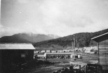
Photograph - Mount Beauty SEC Camp and Town, 1950
The new State Electricity Commission construction camp at the head of the Kiewa Valley was for workmen on the second power station in the project expected to be the most modern and best equipped in Australia… In contrast to the early Kiewa days of horses and canvas tents, the new camp, with its modern amenities, compared favourably with any country town. Administration of the Kiewa Scheme was moved from Tawonga to Mount Beauty in 1946. The first house in Mount Beauty, in Hollonds Street, was occupied by the co-op store manager from November 1946. The new Mess Hall at Mt Beauty was opened with much ceremony in early November 1946. The houses up to Nelse street were erected from 1946 onward and then the township was extended beyond Nelse Street in 1950. The workmen's camp was enlarged in 1950 to the extent of providing accommodation for a total of 1,200.Shows early construction in the town of Mt. Beauty surrounded by hills and farmland, with Mt Bogong in the background. Photo was taken in 1950 during the early stages of construction of the Kiewa Hydro electric SystemBlack and white photograph of Mt Beauty township in 1950 showing original workers buildings. Photograph has a .5cm white border around the photo.Handwritten on back of photograph in blue ink - SEC Camp and Town Mt Beauty 1950mt beauty, secv, mt beauty workmen's camp -
 Kiewa Valley Historical Society
Photograph - Mt Beauty Camp
The new State Electricity Commission construction camp at the head of the Kiewa Valley was for workmen on the second power station in the project expected to be the most modern and best equipped in Australia… In contrast to the early Kiewa days of horses and canvas tents, the new camp, with its modern amenities, compared favourably with any country town. Administration of the Kiewa Scheme was moved from Tawonga to Mount Beauty in 1946. The first house in Mount Beauty, in Hollonds Street, was occupied by the co-op store manager from November 1946. The new Mess Hall at Mt Beauty was opened with much ceremony in early November 1946. The houses up to Nelse street were erected from 1946 onward and then the township was extended beyond Nelse Street in 1950. The workmen's camp was enlarged in 1950 to the extent of providing accommodation for a total of 1,200.Shows early construction in the town of Mt. Beauty surrounded by hills and farmland, with a snow capped Mt Bogong in the background. Photo was taken in approximately 1950 during the early stages of construction of the Kiewa Hydro-electric SystemBlack and white photograph, mounted on corrugated cardboard. Photograph of Mt Beauty townshipHandwritten on back of photograph in blue pen - Permanent loan from Adrian Campan April 96 057-544043mt beauty camp, secv -
 Warrnambool and District Historical Society Inc.
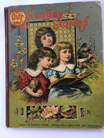
Book, Our Sunday Stories, 1880's
This book was a prize given by the Warrnambool Baptist Sunday School to Richard Petterd in 1888. The Warrnambool Baptist Church was established in 1864 in a small cottage in Kinross Avenue in Warrnambool at the home of Mr and Mrs Andrew Griffiths. In 1869 a church was built in Koroit Street and enlarged in 1974. From time to time more improvements were made and the church still operates from the same site today. A Sunday School was established in 1865. Richard Forrester Petterd, born in 1878 in Warrnambool, was the son of George Petterd and Mary Ann Petterd, nee Warn. He married Susanna McConnell in 1903 and died in 1935. A daughter, Muriel, married Frederick Wooles in 1933 and it was their son, Kenneth from whose estate this book has come to be added to the Society’s collection.This book is most significant as it is a rare memento from the early days of the Warrnambool Baptist Sunday School and it belonged to Richard Petterd whose family was involved in businesses in Warrnambool as picture framers, stationery and fancy goods shop proprietors and estate commission agents. The book is a very attractive example of Victorian-era children’s books. This is a hard cover book of 80 pages It has a multi-coloured front cover depicting three children reading a book with a window behind them and floral decorations and two birds surrounding the three girls. The red binding is somewhat torn. The back cover has black and white etchings of flowers and children and advertisements for other books available. The book has several black and white drawings in grey tonings.‘Warrnambool Baptist Sunday School, Fourth Class United, Third Prize awarded to Richard Petterd, April 10th 1888.’warrnambool baptist church, richard petterd, kenneth wooles -
 Linton and District Historical Society Inc
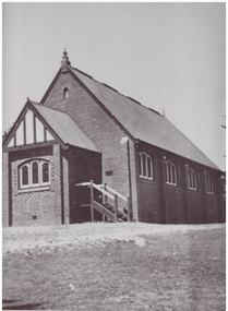
Photograph, Methodist Church, Grantley Street, Linton
Methodist Church meetings and services are known to have been held in tents on the Lintons diggings from the late 1850s. A small wooden church was built in in 1858-59 in Sussex Street, Linton (near where Shepherd's store was located). Sunday School meetings began there in November 1859. By 1860 the church building was considered too small. The land was sold to Mr. Brewer, and the building was removed to a site in Grantley Street and enlarged. Shortly after this, it was decided to build a new church, a wooden structure which was opened in 1861. This building was still in use at the time of the Methodist Church Jubilee in 1910, however around 1905 a fund was established to build a new brick church (pictured), which was opened in 1913. This building was sold and became a private residence about 1979.Black and white photograph of brick church building, leadlight windows in three sections at front and alongside. Sets of steps leading to doors on both sides of church front entrance porch.methodist church linton -
 Linton and District Historical Society Inc
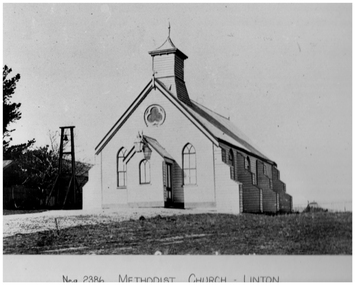
Photograph, Methodist Church, Linton, Timber Construction, Opened 1861
Methodist Church meetings and services are known to have been held in tents on the Lintons diggings from the late 1850s. A small wooden church was built in in 1858-59 in Sussex Street, Linton (near where Shepherd's store was located). Sunday School meetings began there in November 1859. By 1860 the church building was considered too small. The land was sold to Mr. Brewer, and the building was removed to a site in Grantley Street and enlarged. Shortly after this, it was decided to build a new church, also of timber construction, which was opened in 1861. This building (pictured) was still in use at the time of the Methodist Church Jubilee in 1910, however around 1905 a fund was established to build a new brick church which was opened in 1913. This brick building was sold and became a private residence about 1979.Black and white photograph which has been printed as a post card. The photograph shows a timber church which has a kind of turret, and side buttresses. Bell tower on left of picture. Large lamp hanging from entrance porch.methodist church linton, postcards -
 Kiewa Valley Historical Society
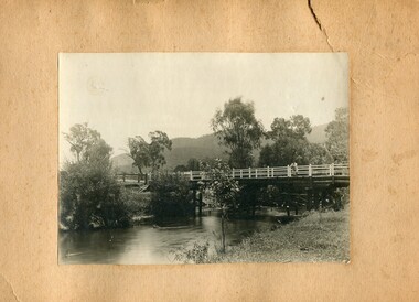
Photographs- 1 old black and white photograph of a wooden bridge over a river possibly Ryders Bridge in Tawonga. 2 –Enlargement of the original photograph showing the gentleman leaning on the bridge. Taken off the original photo
The bridge is not definitively identified, but is of similar construction style to other bridges built in rural areas around this time. Circa 1930”s and may be Ryders Bridge (Old Tawonga Bridge) which crosses the Kiewa River on Mountain Creek Rd Tawonga The first Tawonga bridge was built in 1884- destroyed by floods in 1916. New bridge constructed 1923 and destroyed in 1953. Present concrete bridge constructed in 1986 and named Ryders Bridge These wooden bridges were the only method for transporting stock and produce to market, transporting timber to the mills, sending and receiving mail and for local people to cross the many rivers in the area to go about their daily business. 1- Black and white photograph is glued onto heavy cardboard, which is yellowing with age. Top right hand corner has a tear in the cardboard. Photograph depicts a wooden bridge on wooden piles with 2 white wooden railings along the length of both sides. 2- Original photo has been digitally enlarged to show a gentleman in a light coloured suite and wearing riding boots leaning on the rails of the bridge. The bridge is not definitively identified, but is of similar construction style to other bridges built in rural areas around this time. Circa 1930”s may be Ryders Bridge (Old Tawonga Bridge) which crosses the Kiewa River on Mountain Creek Rd Tawonga bridge; tawonga bridge; kiewa valley -
 Bendigo Historical Society Inc.
Newspaper - JENNY FOLEY COLLECTION: FORTUNA VILLA
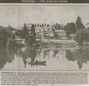
Bendigo Advertiser ''The way we were'' from 2000. Fortuna villa: originally a resplendent villa of two storeys comprising six rooms in the ground floor and five on the second. It was situated beside the New Chum line of reef and was of 350 square metres. In 1887 Fortuna was enlarged with the addition of a mansard between the billiard and music rooms. The entrance hall was demolished and replaced with the hall which stands today. Work continued until 1904 by which time Fortuna was three storeys high. The building was befitting any prince, and soon became an entertainment centre for notable visitors to Bendigo. The spacious gardens adorned with a Pompeii-style fountain and three lakes made Fortuna an idyllic mansion. The clip is in a folder.newspaper, bendigo advertiser, the way we were -
 Ballarat Tramway Museum
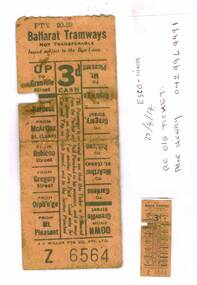
Photograph - Colour Photograph/s, Peter Henry, c2014
Demonstrates aspects of the method of ticketting systems used by ESCo and yields information on the design of the ticket. Has an association with the donor's father.Colour ink jet printed photograph and enlarged photograph of an ESCo tram ticket No. Z 6564, 3d cash fare, up and down directions to specific destinations on the ticket - light brown colour. Donated by Peter Henry 22/4/14 who advised in a phone call on 26/6/14. Story behind the ticket. Peter Henry’s father was involved in the CFA and travelled to Ballarat for the Hose and Reel competitions that were regularly held. He was with the Warburton CFA at the time. Has badges for Geelong 1936 and Bendigo 1930, so ticket would have been in the 1930’s. Peter now lives at Linton. Attached to the sheet of A4 paper is an actual size of the ticket and a donation note.trams, tramways, tickets, esco -
 Melbourne Tram Museum
Book, Topmill Pty Ltd, "Trams of Australia Vol. 1", c1985
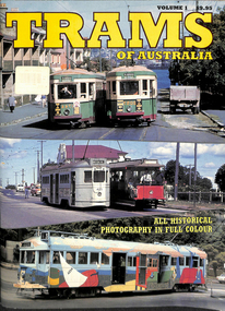
Book - 32 full A4 colour pages + card cover, titled "Trams of Australia Vol. 1", featuring trams in Melbourne, Sydney, Brisbane, Adelaide, and museum operations in Ballarat, Bendigo, Brisbane and Sydney. Melbourne trams featured are: W2 234 Transporting Art L106 Y469 Z25 W2 389 V 214 W6 975 W7 1008 SW6 936 and 956 SW5 814 A279 B2 2112 SW5 812 W2 442 - Restaurant Tram B2 2112 SW6 911 B2 2017 Melbourne photos by Ray Marsh, other photos by Arthur Perry and Noel Reed. See Reg Item 6186 for a revised and enlarged version.trams, tramways, melbourne, sydney, brisbane, adelaide, ballarat, bendigo, w2 class, transporting art, sw5 class, sw6 class, w7 class, restaurant tram -
 University of Melbourne, Burnley Campus Archives
Plan, Royal Botanic Gardens Melbourne, 1978
Plan of RBG with grid references. Produced by Dept. of Crown Lands and Survey, Victoria, Division of Survey and Mapping. Prepared in 1978 from surveys completed in 1976. (1) 2 copies plan. Main areas, buildings, etc., labelled, beds outlined. (2) Original coloured plan and reduced size photocopy. More labelling, particularly beds (handwritten). Labelled Jeremy J. Wallace with handwritten notes on reverse re a project. (3) Reduced size photocopy. Handwritten labelling of beds. (4 - 11) Enlarged photocopies of sections of (1) Handwritten notes and plant labelling. (1). Photgraphed copies by FRESCO 510131-TA. (12) Plan on a grid, coloured. "No Public Access," areas marked.jeremy j. wallace, royal botanical gardens melbourne, department of crown land and survey division of survey and mapping, ornamental lakes -
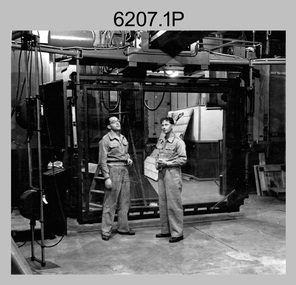 Bendigo Military Museum
Photograph - Photo Troop Equipment and Personnel, Lithographic Squadron, Army Survey Regiment, Fortuna, Bendigo, 1960s and 1970s
This collection of 14 photos were taken at Lithographic Squadron, Army Survey Regiment, Fortuna, Bendigo probably in the 1960s and 1970s. The main tasks undertaken by technicians in Photo Troop were most likely enlargements, reductions and duplication of map reproduction material, and processing of aerial photography. The equipment operated by the technicians is the KLIMCH camera. The main tasks undertaken by the technicians were most likely enlargements and reductions of map reproduction material. The KLIMSCH Commodore camera was introduced in 1953 and was the largest in the Southern Hemisphere. It was replaced with a new model of the same size in 1979. The new model with its computer-based interface provided productivity gains with improved speed and its consistent results led to less wastage in time and materials. See items 6057.8P, 6056.11P and 6058.8P for more information and photos on Photo Troop equipment and personnel. There is more information on the KLIMSCH Commodore camera, on pages 70 and 120 of Valerie Lovejoy’s book 'Mapmakers of Fortuna – A history of the Army Survey Regiment’ ISBN: 0-646-42120-4. This collection of 14 photos were taken in Photo Troop, Lithographic Squadron, Army Survey Regiment, Fortuna, Bendigo probably in the 1960s and 1970s. The photographs were printed on photographic paper and are part of the Army Survey Regiment’s Collection. The photographs were scanned at 300 dpi. .1) - Photo, black & white, 1960s, KLIMSCH Commodore camera, unidentified technicians. .2) - Photo, black & white, 1960s, KLIMSCH Commodore camera, unidentified technician. .3) - Photo, black & white, 1960s, KLIMSCH Commodore camera. .4) - Photo, black & white, 1960s, KLIMSCH Commodore camera, unidentified technician. .5) - Photo, black & white, 1960s, KLIMSCH Commodore camera. .6) - Photo, black & white, 1960s, KLIMSCH Commodore camera, unidentified technicians. .7) - Photo, colour, 1970s, KLIMSCH Commodore camera, unidentified technicians. .8) - Photo, black & white, 1970s, WILD U4A Diapositive Camera, SPR Garry Hudson. .9) - Photo, black & white, 1970s, Photographic camera enlarger, SPR Garry Hudson. .10) - Photo, black & white, 1970s, Photographic camera enlarger, Phil Beaty. .11) - Photo, black & white, 1979, Film developer, SGT Garren Hill. .12) - Photo, black & white, 1970s, Film contact frame. .13) - Photo, black & white, 1970s, LogEtronics Contact Printer. .14) - Photo, black & white, 1970s, Tri-stud registered map separations with composite black negative on top.No personnel are identified. .11P annotated ‘1979’. .13P and .14P annotated ‘orthophoto’royal australian survey corps, rasvy, army survey regiment, army svy regt, fortuna, asr, litho -
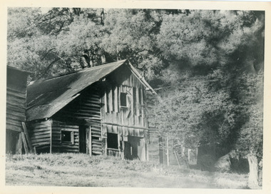 Mt Dandenong & District Historical Society Inc.
Photograph, Isaac Jeeves' Barn
Large barn built c1886 by Isaac Jeeves the younger on his property where the homestead 'Shiloah' stood. The barn was reputedly made from timbers split from only one messmate tree. Originally the home of Isaac Jeeves, brother of Ellis Jeeves, ‘Shiloah’ was enlarged to take guests in the early 1900s. It was situated close to a beautiful fern gully and Isaac and his family capitalised on this by setting out walking tracks through the ferns. They charged 1/- to walk through and this included afternoon tea in a garden setting. ‘Shiloah’ was a popular tourist attraction but the making of the Olinda Creek Road destroyed the fern gullies and, by the 1930s, it was all finished. John Lundy-Clarke grew up in the Kalorama/Mt Dandenong area and later in life (1972-74) began to write a comprehensive history of the area working from an original settlement map in an effort to cover all areas.Black and white photograph showing a large wooden structure surrounded by trees. Handwritten inscription on reverse by John Lundy-Clarke.Home of Isaac Jeeves the younger. Built about 1886 of timbers split from one messmate tree. Photo 1973isaac jeeves the younger, barn, kalorama, shiloah, messmate -
Bendigo Historical Society Inc.
Document - History of the Eaglehawk Croquet Club 1909 to 2003
The Eaglehawk Croquet Club was founded in 1909, in premises vacated by the Eaglehawk Bowling Club. There are no records for the years 1910-1942, but the clubhouse was unlined with no electricity or water. During World War II memberships dropped to just 7 members, however between 1943/46 membership increased to 23. Electricity was connected to the Clubhouse in 1947. During the years 1955-58 the club rooms were rebuilt and enlarged. 1959/63 Life Memberships were presented and the club celebrated its 50th birthday with sister clubs and past members. Golf Croquet was introduced in 1975 and was played on Wednesdays (as is still the case today). The club celebrated its 90th birthday with the oldest member at that time - Nell Mitchell- cutting the cake and a stained glass window was also unveiled. We play Association, Golf Croquet and Golf Croquet Pennant and golf croquet membership is increasing.History of the Eaglehawk Croquet Club 1909 to 2003 - 51 pages of printed history. Includes office bearers, referees and officials, and extensive notes.history, bendigo, chinese, eaglehawk croquet club -
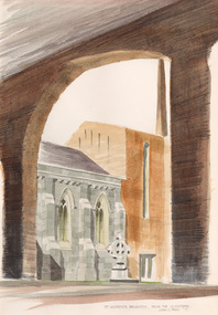 Bayside Gallery - Bayside City Council Art & Heritage Collection
Work on paper - watercolour, John C. Paul, St. Andrew's Brighton, 1971
St Andrew’s Anglican Church, located at 228 New St, Brighton, is the oldest continuous Anglican Church in Victoria. Opened on St Andrews day in 1842, it was one of the earliest Christian churches established in the Port Phillip District. A second church building was erected on the site in 1851, followed by a third building and schoolhouse in 1857 which was enlarged in 1886. A fire in 1961 engulfed the building and renowned Australian church architect Louis Williams was appointed to be the architect of the new building. The present church complex is amongst the largest church buildings in Australasia. Using over 500,000 bricks and over 16,000 roof tiles, this space consisted of three areas: the main church building, the Pioneer chapel and the Lady chapel. The large arcaded cloister, seen in this painting, with an internal cloister garden, is extremely rare in any church in Australasia, and links the Pioneer Chapel to the narthex of the new building.John C. Paul, St. Andrew's Brighton 1971, watercolour, 44 x 30.5 cm. Bayside City Council Art and Heritage Collection. Purchased 1974.brighton, john c paul, st andrews, church, anglican, cloister, arcade -
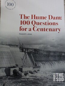 Wodonga & District Historical Society Inc
Book - The Hume Dam: 100 Questions for a Centenary, Howard C Jones, 2019
A booklet describing the history of the Hume Dam in question-and-answer format, illustrated by photographs from the Albury City Collection and other sources. This booklet was produced to accompany the exhibition "Turning the sod: building the Hume Dam", on display at Lavington Library from 21 December 2019 -1 March 2020."non-fictionA booklet describing the history of the Hume Dam in question-and-answer format, illustrated by photographs from the Albury City Collection and other sources. This booklet was produced to accompany the exhibition "Turning the sod: building the Hume Dam", on display at Lavington Library from 21 December 2019 -1 March 2020." hume dam, dams -- new south wales, hume dam history, dams -- new south wales -- design and construction -
 Bendigo Historical Society Inc.
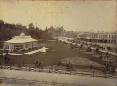
Photograph - CONSERVATORY GARDENS, PALL MALL, BENDIGO
Black and white image (faded to almost sepia colour) mounted on back cover of photo album. Image shows Conservatory building on LH side, Bridge Street looking North West on RH side of image. Conservatory gardens are laid out alongside fence lines, and Conservatory building perimeter. Small palm trees inside fence line alongside Bridge Street, and Bull Street. On kerbside of Bridge Street is a line of 13 horse drawn hansom cabs. On opposite side buildings: Fire Brigade Hotel, W.H. Oakley Undertakers, Dimond Bros. Photo Enlargers, Black Swan Hotel. Gardens are fenced in iron fencing, underneath is placed a (temporary?) small trellis fence. Approx 1880’s?bendigo, streetscape, conservatory gardens, bridge st., bendigo, conservatory gardens, bull street, bridge street, black swan hotel, fire brigade hotel, w.h. oakley undertakers, dimond bros. photo enlargers, hansom cabs -
Bendigo Historical Society Inc.
Map - GREAT EXTENDED HUSTLER'S MINE - TRANSVERSE SECTION OF THE GREAT EXTENDED HUSTLER'S MINE
Transverse Section of the Great Extended Hustler's Mine on the Hustler's Line of Reef. Bulletin No 33, Plate No XII. Shows Poppet legs at the surface and Sill of Shaft at 788.99 feet above Sea Level, Cross Cuts and their depths, stone and geographical features encountered and their references and a number of enlarged drawing of sections of the cross cuts, Geological Survey of Victoria emblem and signed by H A Whitelaw, Underground Survey Office Bendigo, September 1913. The depths of crosscuts to No 21 were taken from plans of surveys by Mr Walker and Mr Craven, noted under Reference. Another note: This Saddle Reef is sketched from Mr Walker's plan. Dividends amounting to 360,000 pounds were obtained from it. This item has not been scanned or photographed.mining, parish map, great extended hustler's mine, transverse section of the great extended hustler's mine, old shaft, mr walker, mr craven, geological survey of victoria, underground survey office bendigo, h a whitelaw -
 Flagstaff Hill Maritime Museum and Village
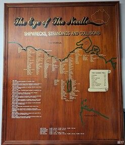
Artwork, other - Shipwreck Board, The Eye of the Needle: Shipwrecks, Stranding's and Collisions, ca 2002
The Shipwreck Board is a feature of Flagstaff Hill Maritime Museum and Village/ its subject is explained briefly in the Museum's handbook, The Flagstaff Hill Navigator, published in 2008: - "Known as the ‘Eye of the Needle’ the treacherous entrance to Bass Strait is littered with the wreckage of large international vessels and smaller sail and steam craft used in coastal trade. The vessels bringing emigrants and cargo to Australia found the western entrance to Bass Strait the most dangerous part of their voyage. They had to thread their way between the southern point of Victoria (Cape Otway) and the northern point of King Island, a stretch of water less than 90 km wide. Many smaller coastal vessels were lost at Portland, Port Fairy, Warrnambool and Apollo Bay which are not safe harbours in certain weather conditions. "The Shipwreck Board shows shipwrecks, strandings and collisions which occurred in this area up to the year 1940. Wrecks are identified by a yellow light and collisions/strandings by a green light. These lights also identify the decade the wreck occurred by lighting up when the relevant decade button is pushed. Interesting happenings of the decades are listed next to the buttons." The Shipwreck Board's demonstration of The Eye of the Needle is an interactive visual display that helps teach the perils and dangers faced by early settlers in Victoria. It tells of the vast number of lives lost. It lists the names of many infamous shipwrecks and significant events.The large stained and lacquered timber board is mounted in a timber, frame. It is painted with a small sketch of Australia, and an enlarged outline of the southern coast of Victoria, King Island and the North West coast of Tasmania. The interactive display highlights the shipwrecks, standings and collisions suffered by many vessels as they navigated the 'Eye of the Needle', a narrow stretch of Bass Strait. The locations of the Lighthouses are pinpointed. Lists of groups of ships are below the coastlines. A painted scroll shows eight major shipwrecks with the number of lives lost for each one. A table shows historical facts associated with the decades from pre-1830 to 1940. A system of coloured lights compares the decades with the vessels that suffered damage. The board was created by artist and signwriter, Alex O'Flynn Computer Signs.flagstaff hill, maritime museum, maritime village, shipwreck coast, eye of the needle, shipwreck locations, bass strait, basses strait, king island, north west tasmania, south coast of victoria, cape otway, victorian lighthouse, king island lighthouse, strandings, coastal tracers, emigrant ships, sea trade, 1930s-1940s, shipwreck board, the eye of the needle, collosions, alex o'flynn, alex o’flynn computer signs, shipwrecks of western victoria -
 Linton and District Historical Society Inc
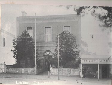
Photograph, Shire of Grenville Hall and Angus Shop, Sussex Street, Linton
Shire of Grenville Hall and Angus shop, Sussex Street, Linton. Dating the photograph: The photograph can be dated to after 1887, when John Angus purchased the shop building (originally owned by Thomas Austin) from B. N. Dodd. 'W. Angus': From 1887 until the late 1890s the shop was run by John Angus' wife Wilhelmina Angus, who often advertised her business in the local newspaper, the 'Grenville Standard' (see photograph of advertisement, Registration no. 2019-346). It is not known when Mrs Angus retired, but it is understood that her son William then took over the shop. Elsie Jennings, an Angus descendant, recalled in a letter to LDHS that her uncle had run a draper's shop at this site. (See letter in "Linton - Township History - Recollections and reminiscences' file.) It is not clear whether the "W. Angus" in the sign refers to Wilhelmina Angus or to William Angus.Enlarged black and white copy of original photograph, which has been mounted on white card. The photograph shows a two-storey brick building, and next to it a double-fronted shop. The two-storey building is the original Grenville Shire Hall, built in the mid 1860s. The fence outside it is being used to post notices. Two large pine trees are between the fence and the building. The smaller shop next to the hall has a verandah supported by round timber posts, and signs across the front of the verandah read "Tailor" and "W. Angus". Two men engaged in conversation with each other are standing to the left under the verandah. There is a flagpole attached to one of the gate posts of the hall, and there is a telegraph pole in the street in front of the hall.w. angus, william angus, wilhelmina angus (née statemann), buildings, shire of grenville hall, shops, shire hall, town hall -
 Flagstaff Hill Maritime Museum and Village
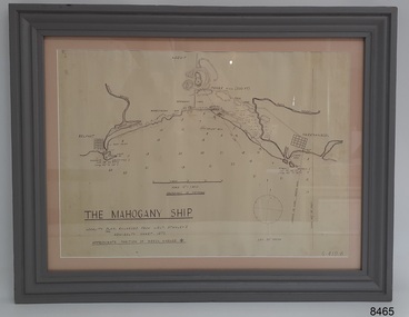
Document - Location Chart, The Mahogany Ship, 2007
This chart shows a possible site for the fabled wreck called the 'Mahogany Ship'. Flagstaff Hill’s collection includes other objects that some say could be relics from this Ancient Wreck, (also called the Gold Ship, or the Ancient Vessel). The chart shows the coordinates for the Summits of Griffith Island and of Middle Island. It also has the depths of the sea at various intervals and shows the shore and sand dunes, lighthouses and other reference points. The mystery of the Mahogany Ship began in 1836 when two shipwrecked sealers discovered the remains of an “ancient vessel” in the sand dunes about four miles west of Warrnambool. Since the last recorded sightings in the 1880’s the true origin of the Mahogany Ship has remained one of Australia’s most famous historical mysteries or fables. One of the more recent theories is that the vessel was one of the Portuguese ships exploring the Australian coast in 1522. For over one hundred years searchers have attempted to locate and identify the wreck. The search continues for the tangible evidence which will once and for all establish the Mahogany Ship’s place in Australia’s History.The chart represents the worldwide interest in locating the wreck of the Mahogany Ship. Locating the actual wreck or proving the existence of a Portuguese ship's wreck could change the history of the discovery of Australia. A Mahogany Ship committee was formed to gather and research information about the discovery of the wrecked ship. A large amount of money was offered as a prize for finding the wreck or parts of it. People have written books, painted images, made videos and told tales of the ship but it continues to remain a mystery or even a fable. The chart is significant for its possible link to one of Victoria’s and Australia’s maritime mysteries, the Mahogany Ship (also known as the Ancient Wreck). It is one of very few known relics that could give evidence of the existence and history of the vessel. It is listed on the Victorian Heritage Register S438 as it is one of Victoria’s oldest recorded shipwrecks. The identity of the vessel has the potential to change Australia’s history.A chart in a wooden frame, behind glass. The chart shows the approximate position of the mystery Ancient Wreck, later called the "Mahogany Ship". The chart is a copy and is based on the Admiralty Chart by Lieut. Stanley, dated 1872. Lower left: "THE MAHOGANY SHIP" "LOCALITY PLAN, ENLARGED FROM LIEUT. STANLEY'S ADMIRALTY CHART 1872" "APPROXIMATE POSITION OF WRECK MARKED [symbol of a Portuguese cross]" Other labels on chart: "BELFAST" "PORT FIARY" "GRIFFITHS I" "RIVER MOYNE" "RIVER MERRI" "ARMSTRONG BAY" " GORMANS LANE" "TOWER HILL" "KOROIT" "HELEN ROCK" "WARRNAMBOOL" "LADY BAY" "MIDDLE I" "LIGHT HO." Lower right: "G 410 B" Label on the back; "This chart presented to the Mahogany Ship Committee and Flagstaff Hill by Avis Quarrell, April 2007"warrnambool, shipwrecked coast, flagstaff hill maritime museum, shipwreck coast, mahogany ship, ancient vessel, ancient wreck, portuguese ship, coastal reserve, fabled wreck, gold ship, griffiths island, belfast (now port fairy), koroit, location plan, leuit. stanley, admiralty chart 1872, tower hill, merri river, moyne river, middle island, helen rock, armstrong bay, griffiths land -
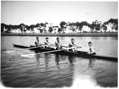 Hymettus Cottage & Garden Ballarat
Photograph, Ballarat Rowing Club
This image of the Ballarat Rowing Club in 1947 records the placings of threw crews in the Barwon regatta at Geelong in 1947 and the Ballarat Regatta in 1947. It also records the first time a new rowing style, "Leg and Body Drive" was used in rowing on Lake Wendouree at Ballarat.Photograph has light from lens across right side. Reverse has ink inscription: "Ballarat Rowing Club Lightweight Maiden Four Ballarat and Barwon Regattas, 1947. L Wallis Bow, J Nolan (2) E. McLenehan (3), J Trainor Stroke, W Hancock. Cox. Coach - Ken Baird. First crew to introduce "Leg and Body Drive" style on 14 starters at Ballarat defeated by Banks Rowing Club by three feet / Eliminated by Footscray at Barwon who won final. Stamp to centre Kodak Enlarged Print. -
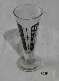 Flagstaff Hill Maritime Museum and Village
Container - Medicine Glass, J.W. Small & Co, early 20th century
This measuring glass for fluids was used mostly used for medicines but could have been used for measuring photography chemicals. The glass was once owned by Dr W R Angus, who practised in Warrnambool in the 20th century. It was donated by members of his family. Dr Angus enjoyed photography amongst other hobbies. The maker, J.W. Small & Co. was a long established camera and photography business Camera Corner, in 270 Little Collins Street, Melbourne. At the 1887 Melbourne Exhibition the company showcased bicycles as well as a wide range of photography equipment including cameras and any other accessories and needs for the amateur photographer. In 1887 the sole proprietor of the business was Mr Herbert Small. The firm offered the service of developing and enlarging pictures. In 1894 the firm advertised as photographic and lantern material manufacturers. There were branches in Adelaide and Sydney also. The company was still in business in the 1920's, when Dr Angus graduated as a doctor and surgeon.The medicine glass is significant for its association with Dr William Roy Angus, who practice medicine in Warrnambool for several decades. He and his wife were heavily involved in the community. Dr Angus was also connected to the maritime history of Warrnambool, being the last Port Medical Officer. The glass is also associated with the Melbourne company J.W. Small &O Co, which was 'long established' in 1887.Medicine glass (dose cup or measuring glass), for measuring fluids. This glass holds 1 fluid ounce. Wide mouth with pouring lip tapers sharply to narrow centre of the base, which has a round flat foot. Black inscriptions are on the side of the glass, showing fluid ounces and fluid drachmas. An opaque label on the back shows maker details. The other side has a label. The glass was made in England for the Australian company J.W. Small & Co. It is part of the W R Angus Collection. "FLUID OUNCES" "FLUID DRACHMS" "MADE IN ENGLAND / FOR / J.W. SMALL & CO / MELBOURNE, SYDNEY AND ADELAIDE"flagstaff hill, warrnambool, shipwrecked-coast, flagstaff-hill, flagstaff-hill-maritime-museum, maritime-museum, shipwreck-coast, flagstaff-hill-maritime-village, measuring glass, dose cup, medical equipment, medicine glass, medication administration, w.r. angus, j.w. small & co, fluid measurment, photography equipment -
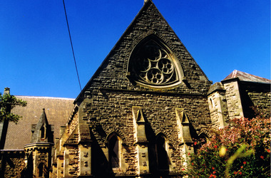 St Kilda Historical Society
Photograph, Christ Church St Kilda exterior - images collection #1
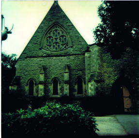
Christ Church was constructed in 1854-57 and designed in Decorated Gothic style by Albert Purchase & Charles Swyer. It was enlarged in 1874 and 1881 to the designs of Sydney W Smith. It is one of four main buildings constructed on land granted to the Church of England in 1855 and named Church Square. The other buildings are the bishop's residence, vicarage and parish hall. Heritage Victoria describes it as a 'rare and significant square in the history of town planning in Victoria which demonstrates the importance of the church to the community'. It is built from rarely used undressed random coursed sandstone from Point King Sorrento. It is located at 14 Acland Street, St Kilda. The triangular rose window is said to have been modelled on Lichfield Cathedral and shows outstanding craftsmanship. According to Heritage Victoria, the only other known example in Victoria is at St Georges Presbyterian Church in East St Kilda, designed by the same architect, Albert Purchas.colour photograph unmountedrose window, acland street, purchase, swyer, st kilda, christ church -
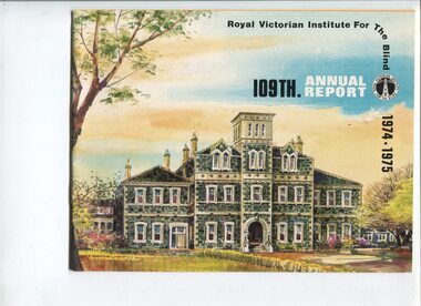 Vision Australia
Administrative record - Text, Royal Victorian Institute for the Blind annual report 109th 1974-1975, 1974-1975
Articles in annual report include: List of RVIB president, vice president, board of management, medical staff and officers of the institute, honorary officers and consultant medical staff, President's report, The children - independence and achievement, Our Christmas party, Multi handicapped blind children, Training and understanding at Burwood centre, Financial independence through employment, Training confidence and achievement, Expansion of welfare services, Other services, Carols by candlelight, Auxiliaries and other generous helpers, Public education, Finance, Services and facilities, When you make or amend your will. Events that occurred in 1974 : Two permanent welfare officers in the country at Wangaratta and Sale, Re-equipment programme for the library and enlarging the range of books and magazines available to readers, Burwood centre for multi handicapped blind children separate to school - accommodation for twenty-four, Training department started instruction in use of hand tools - two clients gained employment in wood assembly. 1 volume of text and black and white photographsroyal victorian institute for the blind, annual reports -
 Eltham District Historical Society Inc
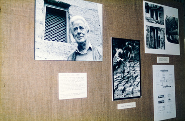
Photograph, Peter Bassett-Smith, Alistair Knox collection, 1988
Wall display of photographs and cabinets of books as part of the Bicentennial/Heritage Week Display, "The Eltham Tradition", held in the Eltham Shire Office, 17-22 April 1988 by EDHS. The Alistair Knox Collection is a series of mounted enlarged photos of about forty images mud brick houses and related subjects. The collection is understood to have been put together by Alistair Knox although it is the work of several unacknowledged photographers. For some years it was held by the Building Department of the former Eltham Shire Council and was then passed to EDHS. Some of the photos have been used in Knox's books. Alistair Knox (1912 - 1986) is acknowledged as the founder of Eltham's mud brick building movement. Many of the buildings shown in the collection are of his design and he was also involved with the construction of several of them. Others are the work of his contemporaries and associates such as Peter Glass, Gordon Ford, and John Harcourt. (EDHS Newsletter No. 145 July 2002) Two colour photographsactivities, eltham shire office, heritage display, heritage week, alistair knox -
 Eltham District Historical Society Inc
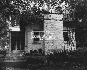
Photograph, Tim and Betty Burstall House (1948-1960s)
Tim and Betty Burstall designed and built their mud brick house in (68 Napier Crescent) Montmorency in 1948. Extensions were added in the 1960s. The Alistair Knox Collection (Image 6) The Alistair Knox Collection is a series of mounted enlarged photos of about forty images mud brick houses and related subjects. The collection is understood to have been put together by Alistair Knox although it is the work of several unacknowledged photographers. For some years it was held by the Building Department of the former Eltham Shire Council and was then passed to EDHS. Some of the photos have been used in Knox's books. Alistair Knox (1912 - 1986) is acknowledged as the founder of Eltham's mud brick building movement. Many of the buildings shown in the collection are of his design and he was also involved with the construction of several of them. Others are the work of his contemporaries and associates such as Peter Glass, Gordon Ford, and John Harcourt. (EDHS Newsletter No. 145 July 2002)Handwritten notes in pencil re details of building, year of construction, owner, designer, builder, etcbetty burstall, houses, mud brick construction, tim and betty burstall house, tim burstall, montmorency, alistair knox collection -
 Warrnambool RSL Sub Branch
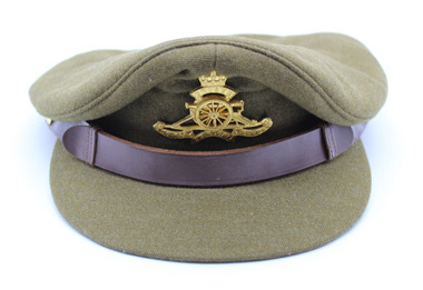
Peaked Hat - Army, Military Uniform, Date unknown - Manufacture: Commonwealth Government Clothing Factory, Melbourne
As an historic army uniform with an association to Victoria this item is of local historic and social significance. It is also in very good condition. Woolen khaki peaked hat has a central head band with solid peak connected to the lower front of the head band. The top is high at the front and protrudes out from the headband about 3cm on all sides. There is a brown leather chinstrap on the lower front of the headband above the peak and this has a slide extension that can be enlarged to go under the neck to keep the hat in position in high winds. The chin strap in connected to the headband with two plastic button that have queens crown above a map of Australia. Affixed to the front of the headband above the peak is the Artillery Corps metal hat badge in gold colouring. The interior of the top of the hat has a cotton lining under the woollen exterior and then a plastic protective lining to avoid sweat bleeding onto the exterior. A cloth badge with the makers name sewn to the cloth lining and covered by the plastic protective layer. uniform -
 Ballarat Tramway Museum
Photograph - Black & White Photograph/s, Dave Macartney, 23/12/1967 12:00:00 AM
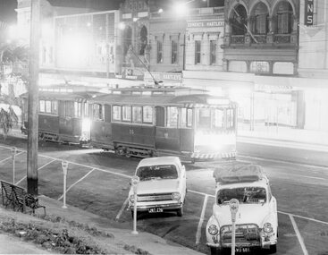
Black and white photograph of SEC Trams 26 and 28 in the City Loop on 23.12.1967 in the evening. Both trams have their lights on. Two motor cars parked with parking meters. In rear are the buildings on the south side of Sturt St to the west of Grenville St. Buildings in view are "Edments Hartleys", "Gear Chemist" and "Patersons". Photo by Dave Macartney - 23/12/1967. Copy1 - Photocopy made 4/1999 for display purposes. Copy 2 - made by enlarging photo to an approx. A4 print by colour photocopying and laminated for display purposes. Made July 2000 for the Trams at Night exhibition in the depot. Made by W.Doubleday. Has four Velcro dots on rear. Overall size 203H x 268W. Stored in same box at rear of large photos area in an A4 plastic folder.trams, tramways, sturt st, city loop, night photo, tram 26, tram 28 -
 St Kilda Historical Society
Photograph, 26/11/1978
Image taken on a bus trip, 26 November 1978. Christ Church was constructed in 1854-57 and designed in Decorated Gothic style by Albert Purchase & Charles Swyer. It was enlarged in 1874 and 1881 to the designs of Sydney W Smith. It is one of four main buildings constructed on land granted to the Church of England in 1855 and named Church Square. The other buildings are the bishop's residence, vicarage and parish hall. Heritage Victoria describes it as a 'rare and significant square in the history of town planning in Victoria which demonstrates the importance of the church to the community'. It is built from rarely used undressed random coursed sandstone from Point King Sorrento. It is located at 14 Acland Street, St Kilda. The triangular rose window is said to have been modelled on Lichfield Cathedral and shows outstanding craftsmanship. According to Heritage Victoria, the only other known example in Victoria is at St Georges Presbyterian Church in East St Kilda, designed by the same architect, Albert Purchas.colour photograph polaroidSKHS Bus trip 26/11/78 Christ Churchrose window, acland street, purchase, swyer, st kilda, christ church, churches -
 National Wool Museum
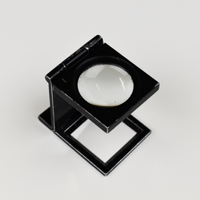
Tool - Lens, c.1960
Nino Corda was a Geelong based textile designer who worked at various textile mills between 1957 & 2003. He travelled the world in search of the latest fashions and techniques and developed timeless designs that were much loved by Australians. These items are on rotational display at the National Wool Museum’s ‘In the Factory’ exhibition. For many years, Nino also worked as part of the Honorary Staff of the National Wool Museum. His passion for the world of textiles provided energy and knowledge to the visitors and staff of the museum. Although Nino has now retired from his honorary position and has hung up his Australian Tartan vest, these items will continue to serve the community in sharing the stories of Australian Textile design. Textile designers used viewing lenses such as this to see how many threads are within a textile sample. It was important to count correctly, otherwise the enlarged final pattern would be out of alignment. Before compact lenses such as this, specialised glasses were used such as 8039.The viewing lens has a 3 fold design in order to fold up to be compact and easily transportable in a pocket while also working to provide its own stand when unfolded. The lens is black and contains one circular piece of magnifying glass on the top panel.Top panel. Words, scratched. NINOtextile calculations, textile design