Showing 523 items
matching field house
-
 University of Melbourne, Burnley Campus Archives
Album, Sandra Pullman, National Estate/Heritage Register Photographs, 2001
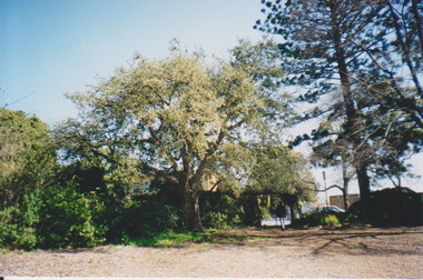
Photograph Album sent in with the National Estate/Heritage Register by Sandi Pullman. (1) Old car park (Bull Paddock) with Cork Oak. (2) Main Building front steps. (3) Main Building with Magnolia grandiflora. (4)View of Luffmann Ponds and old willow. (5) View of Ginkgo and Emily Gibson bed. (6) Looking between Emily Gibson beds to English Oak. (7) Summer House. (8) Luffmann Ponds. (9) Bergenia Walk with conifers. (10) View of Pencil Pines around entrance to Sunken garden. (11) Luffmann Ponds and Pinus canariensis. (12) View of entrance to Sunken garden. (13-14) Sunken garden. (15) Original terracing at entrance to Shady Walk. (16) Pears in blossom in Field Station. (17) Agathis robusta from the Herb Garden. (18) Ellis Stones Rock garden newly replanted. (19) james Hitchmough Grasslands. (20) Elm tree with Dairy in the background. (21) Original Red Gum in james Hitchmough Grasslands. (22) Kath Deery Native garden. (23-24) Rose Garden. (25) Sequoiadendron giganteum.national estate, heritage register, sandi pullman, sandra pullman, bull paddock, cork oak, magnolia, luffmann ponds, willow, ginkgo, emily gibson bed, english oak, summer house, bergenia walk, conifers, pencil pines, sunken garden, pinus canariensis, shady walk, pears, blossoms, field station, agathis robusta, herb garden, ellis stones rock garden, james hitchmough grasslands, elm tree, dairy, red gum, kath deery native garden, rose garden, sequoiadendron giganteum. -
 University of Melbourne, Burnley Campus Archives
Album - Digitised, Joanne Morris, Visit to Burnley April 2014, 2014
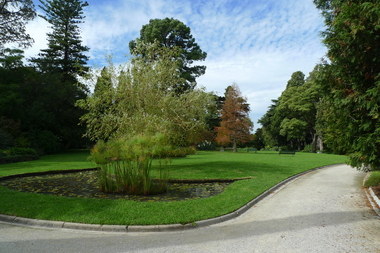
Collection of digitised photographs taken in preparation for the Class of 1973 Reunion in 2014. Garden views and buildings. Donated by Joanne Morris, former student, in June 2014. See Digitised photos- Garden Views folder- Visit to Burnley April 2014. (1) Luffmann Ponds. (2) Administration Building. (3) Emily Gibson Beds and Ginkgo biloba. (4) Looking towards Native Garden. (5) Oak tree. (6) Looking towards Rose Garden. (7) Looking towards Stream Garden and Fern Garden. (8) Looking towards Rose Garden. (9) Plaque at entrance to Field Station. (10) New gates at entrance to Field Station donated by the Friends of Burnley Gardens. (11, 12) Field Station. (13) Plaque in Herb Garden commemorating Enid Carberry. (14) Fountain in Herb Garden commemorating Enid Carberry. (15) Forestry Building. (16-18) Inside Forestry Building. (19) Sugar Gum Table Setting donated by the Friends of Burnley Gardens. (20) Plaque on Sugar Gum Table commemorating Geoff Olive. (21, 22) View of Luffmann Ponds and Summer House. (23) Plaque at Luffmann Ponds. (24) Luffmann Ponds. (25) View of former Egg-Curator's Residence from Nursery. (26) Back of Nursery. (27,28) The Burnley entry for the Melbourne International Flower and Garden Show 2014. (29) Back of Administration Building. (30) Plant Science Laboratories. (31) Student Amenities Building. (32-34) Plant Science Laboratories. (35) Citriodora Court. (36) Eucalyptus maculata at entrance to Native Garden. (37) Native Garden, James Hitchmough Grasslands. (38) Garden view. (39) Inside the Hall. (40,41) Roof Garden. (42,43) Library. (44-50) Views of the Quad and classrooms. (51) Dairy. (52) Building 904,(Centre for Urban Horticulture) now Waterway Ecosystem Research Group. (53) Yarra Boulevard entrance.class 1973, class reunion, garden views, buildings, joanne morris, students, luffmann ponds, administration building, emily gibson beds, ginkgo biloba, native garden, oak tree, rose garden, stream garden, fern garden, field station, friends of burnley gardens, plaques, herb garden, enid carberry, fountain, forestry building, sugar gum table, geoff olive, summer house, egg-curator, residence, nursery, melbourne international flower and garden show, 2014, plant science laboratories, student amenities building, citriodora court, eucalyptus, james hitchmough grasslands, roof garden, library, quad, classrooms, dairy, centre for urban horticulture, waterway ecosystem research group, yarra boulevard entrance -
 University of Melbourne, Burnley Campus Archives
Photograph - Black and white print, Ploughing in Cover Crop, 1949
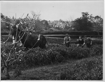
Identified by T.H. Kneen as, L to R George Manley (Stockman Assistant), Valerie Green (1st Year Student), Harold Marshall (Gardening Instructor- Orchard.)"Black and white photograph. 2 Instructors and female student with horse and plough in the Orchard. Well trimmed hedge at far side of field. Draught horse pulling the plough. Houses of Hawthorn on hill in background.On reverse,"Burnley Gardens. Ploughing in Clover Crop-Sept. 1949."instructors, female student, horse, plough, orchard, burnley gardens, george manley, stockman assistant, valerie green, harold marshall, gardening instructor, students working outside, draughthorse, cover crop -
 University of Melbourne, Burnley Campus Archives
Album - Black and white and colour slides, Burnley Views, 1947-1955
Contributor: T.H. KneenCardboard box of 108 35mm glass slides in metal frames made by "Gnome." Box labelled "Burnley Gardens Slides." Also 16 unused slides (1) Swan Street entrance c. (2) Orchid? b/w. (3) Nursery b/w. (4) Pasture area with man working b/w. (5) Draught horse working in the Orchard b/w. (6) Crop of corn in the Orchard c. (7) Magnolia c. (Magnolia x soulangeana). (8) Display of orange flowers c. (9) Lemon tree in the Orchard c. (10) Sign advertising 'Fruit Tree Pruning Demonstarion Sat. 2nd July (1949) c. (11) Jersey cow c. (12) Rock Point c. (13) Dahlias in the Orchard c. (14) Foundation Stone '28th August, 1946' c. (15) Felled Cypress tree 1951 b/w. (16) School truck in front of glasshouses and cacti b/w. (17)Administration Building completed but surrounded by rubble C.1949 c. (18) Plant Research Institute c. (19) Inside a glasshouse. c. (20) Administration Building c. (21) Group of female students dressed up for a function c. (22) Solenostemon (Syn. Coleus) in a glasshouse. (23, 24)Stock Matthiola incana. (25) Blossom in the Orchard c. (26) Orchard c. (27) Picking fruit in the Orchard c. (28) 2 female students holdong large bunches of poppies c. (29) Flowers growing in the Orchard c. (30) House - not Burnley c. (31) Students on an excursion c. (32) Staff member with Gladioli c. (33) Garden view - not Burnley? c. (34) Administration Building c. (35) Roses c. (36) Flowers in the Orchard c. (37) Draught horse working in the Orchard c. (38) Staff member amongst flowers in the Orchard c. (39) Garden view c. ((40) Blossom in the Orchard c. (41) Orchard c. (42) Flowers inside glasshouse c. (43) Mesembryanthemums in pots possibly in the nursery c. (44) Tree b/w. (45) Garden bed c. (46) Sign, 'Agrostology Branch, pasture Plant Research Field,' c. (47) Path to Principal's Residence c. (48) Irrigation in the Orchard b/w. (49) Cactus flowers b/w. (50) Garden view with T.H. Kneen children playing c. (51) (52) Cinerarias (now Pericallis x hybrida) in pots c. (53) Temporary building where the Grey Garden is now b/w. (54) Garden view b/w. (55) Unknown building b/w. (56) Person pruning in the Orchard c. (57) Students working in the Orchard c. (58) Swan Street with recently completed rock wall constructed by the Public Works Department b/w. (59) Lagoon paddock b/w. (60,62) Pavilion and new Administration Building before the Pavilion was removed b/w. (61) As (60) but viewed from a different direction c. (63) Plant c. (64) View through a window on the stairs in the Administration Building c. (65) Plant c. (66) Garden view of trees c. (67) Garden View b/w. (68) Blossom tree c. (69 )Garden view along path to Principal's Residence c. (70) Lagoon Paddock c. (71) Lagoon Paddock with cows b/w. (72) Inside a glasshouse b/w. (73) Entrance sign- Department of Agriculture Burnley Gardens, School of Horticulture & Primary Agriculture, Plant Research laboratory, Agrostology Branch, Fruit Preserving Branch c. (74) Plant Research Laboratory b/w. (75) Students on an excursion c. (76) Glasshouses b/w. (77) Garden view b/w. (78) Kniphophia c. (79) Hibiscus c. (80) Garden view c. (81) Dairy, Silo and dog b/w. (82) Irrigation in then Orchard b/w. (83) Garden view with magnolia c. (84) Flower plots in the Orchard c. (85) Pruning demonstration b/w. (86) Administration Building under construction c. (87) Rock Point c. (88) Mrs Kneen and Magnolia c. (89) Glasshouses c. (90) Sequoia sempervirens b/w. (91) Inside Administration Building c. (92) Luffmann Ponds b/w. (93) Sequoia sempervirend, Mrs Kneen and child c. (94) Garden bed in front of Sequoian sempervirens c. (95) Principals Residence b/w. (96) Poultry pens b/w. 1947 (97) Principals Residence b/w. (98) Student picking fruit from netted tree b/w. (99) Rock Point and Long Border c. (100) Administration Building under construction c. (101) Greenhouse b/w. (102) Rock Point c. (103) Flowers in the Orchard c. (104) Waterlilies in the Pond c. (105) Blossom tree c. (106) Hilda Kirkhope Rockery c. (107) Long Border c. (108) Plant Research Institute with flower border along drive c.burnley gardens, flower, nursery, pasture, draught horse, orchard, crops, magnolia, chicken coops, egg laying competition -
 University of Melbourne, Burnley Campus Archives
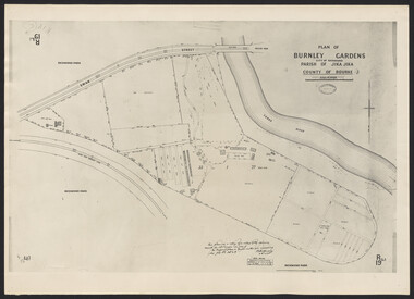
Photograph - Plan of Burnley Gardens
"This plan is a copy of a copy of the survey made by Mr. Turner in 1926. The original plan and field notes are missing _ file Rs 3529" Signed by _signature unreadable_ -
 Ballarat Diocesan Historical Commission
Flag, House Flag McAuley College Dooboobetic
McAuley College was established at Dooboobetic in 1977 as a Catholic consolidated secondary college bringing together secondary catholic students from Donald, St Arnaud and Charlton in Victoria's Wimmera. A new school was built on a 23-acre site at Dooboobetic constructed from mostly portable classrooms among wheat fields, five minutes from the Gooroc church. The college served the north-west from Wycheproof to Wedderburn. The concept proved unsustainable and the Dooboobetic campus was closed in 2003 marking the end of a century of Catholic secondary education in the district. -
 The 5th/6th Battalion Royal Victoria Regiment Historical Collection
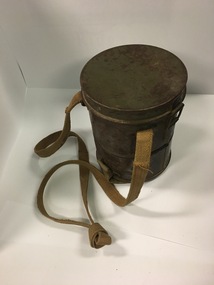
Equipment - Field Equipment - German WWI Gas Mask Tin, WW1 German Gas Mask Tin, 1918
Late WWI German gas mask tinThis item was used by German soldiers to house and carry gas masks to protect them against chemical weapons during WW1Late First World War German field grey carry tin for gas mask. One tan cotton strap for wearing over the wearers shoulder. Shorter tan cotton strap with button hole to attach to wearers belt. Inside tin lid has piece of paper with German inscriptions.Inside tin lid has piece of paper with German inscriptions. Inscription 'SS' overlapping on tin lid lip.ww1, gas mask, tin, german, wark vc club -
 Wodonga & District Historical Society Inc
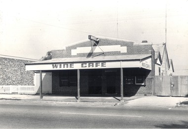
Slide - Mann Collection Album - High Street West from Lawrence Street - old Wine Café, C. 1940s
Elaine Mann was married to David Mann, a successful Wodonga businessman and community leader who passed away in Wodonga in June 2012. David was a member of the Mann family who began their business in Wodonga in 1920. Elaine was a teacher in Wodonga for many years and an active member of the community.This photo collection is of significance as it documents how the businesses and buildings in Wodonga have evolved and contributed to community throughout the late 20th century.This image is reproduced from a set of coloured slides. The Wine Café on High Street next to Woolworths Food Fair Supermarket. It was owned by the Costa family for many years, then taken over by Josephine Adams Bernardo Costa was born in Switzerland in 1829 and left his homeland for Sydney at the age of 27. He ventured south to the gold fields of Beechworth and Yackandandah. He moved to 1891. Bernardo applied for and was granted a wine licence on 24/14/1887 and established his Wine Saloon. After his death in 1915, the Wine Café continued to be operated by his daughters Annie, Angela and Gertrude. They also operated a boarding house behind the café. The business operated under a range of owners for approximately 72 years, closing in about 1963. It was estimated that hundreds of thousands of gallons of wines of all kinds were sold there. On façade of building "WINE CAFE"wodonga businesses, high street wodonga, woolworths food fair, peard plumbing, roy benson -
 Wodonga & District Historical Society Inc
Photograph - Mitta Junction Township
Mitta Junction which was established about 1920 on the Victorian side of the Hume Dam construction site (originally called the Mitta Junction Reservoir). The town was built to house workers and their families. It included houses, private and government boarding houses, a shop, hall and school as well as tennis courts and a cricket pitch. Mitta Junction was a thriving community with many activities, including Balls and Euchre Nights, held at the Hall which opened in February 1922. The community also fielded a very successful football team in the local competition. After the completion of the Dam, the village and all its contents were sold at auction in June 1936 for £7,000. Individual houses sold at about £40 for removal to nearby towns. The Mitta Junction School which opened in 1922 continued to operate with very small numbers after the village was moved. Its numbers were boosted in the early 1980s by the children of Army staff at the nearby Latchford Barracks Army Apprenticeship School. It finally closed in December 1985.These images are significant because they capture the history of an important vanished town whose residents played a vital role in the construction of the Hume Dam.A collection of black and white images and a sketch map featuring the village of Mitta Junction, built to house workers on the construction of the Hume Dam. Some of the photographs have been mounted on heavy card.mitta junction township, hume dam construction, hume dam history -
 City of Kingston
Photograph - Black and white, c.1945
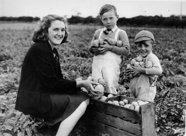
This photograph shows Gladys Marriott, aged 15, in the potato fields of her father's property in Moorabbin. Her cousin Graeme (centre) and younger brother Alfred (right) are with her. Moorabbin is a suburb in the City of Kingston that was originally established as a rural market gardening communityThe Marriott property in Moorabbin was adjacent to a secret wartime wireless receiving station established in March 1942 in Chesterville Road, Moorabbin. The station was established on requisitioned market garden properties, and soon housed WRAN (Women's Royal Australian Navy) personnel and up to 35 US Navy servicemen. The Navy personnel intercepted Japanese coded communications and then despatched these by motorbike messenger to Queens Road, St Kilda where the Directorate of Naval Communications and the code-breaking unit called FRUMEL (Fleet Radio Unit - Melbourne) were housed. The information intercepted by the wireless receiving station helped shape the Allied response to Japan's advances in the Pacific. Declassified defence records show that this unprepossessing station handled some of World War II's most sensitive secrets, however the local community were unaware of its significance. Gladys Marriott, working on her father's property, would regularly take the family's cows to graze in the fields adjoining the station with no concept of what the Navy personnel were doing. Black and white photograph of a young woman and two small boys standing around a wooden crate filled with potatoes. They each have potatoes in their hands. They are standing in a field. Handwritten in red ink: A 601 / 72% Handwritten in black ink: CHAP 6. Handwritten in black ink: GLADYS STOTT (MARIOTT) / DURING WAR YEARS / With Spybase Storymarket garden, children, farming, local production, world war ii, wireless receiving station, moorabbin -
 Melbourne Legacy
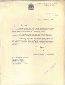
Letter, Queen's Visit 1970
Correspondence dated 24 February 1970 - 6 March 1970 concerning an invitation to a Dinner Dance at Government House on 7th April 1970 in honour of The Prince of Wales and The Princess Anne, hosted by Miss Frances Anne Delacombe. The Governor, via his Private Secretary Lt.Col W.H.A. Becke, asked Melbourne Legacy to nominate two male and two female members between the ages of 18 and 25 who had achieved something in the scholastic, sporting or community service fields. They also had to like dancing and be able to mix. The Junior Legatees selected were Mary W. Lahore, Jacqueline Isles, Ralph E. Norton, and Peter Smith, all of whom were University students.Illustrates Melbourne Legacy's relevance in the wider community at the highest levels.Quarto and foolscap typed sheets x 3 on letterhead stamped 'Copy Only'. Originally black type on white paper, now fading to brown on cream.Handwritten salutation and signature on 01286.1 and 01286.4.junior legatee, royal visit -
 Melbourne Legacy
Letter, Re: Residences - Future of Individual Residences
Letter dated 29 November 1973 from (Legatee) A. Quale, Chairman, Residences Committee, to Legatee H.C.G. Rodgers appointing him to the Steering Committee (Residences) and laying out the terms of reference, and the investigations to be undertaken in order make recommendations about the future of the Melbourne Legacy residences. Members of the committee were selected with particular reference to their experience in certain fields and responsibilities allocated accordingly; Legatee Rodgers was tasked with forecasting occupancy levels for the following 10 years. Legatee Rodgers noted that copies of the titles for Blamey House and Harelands were to follow.Part of the history of Melbourne Legacy's involvement with residential care for children.Photocopied letter on letterhead, some original typing, black on white. Signed in blue biro 'Allan Quale, per (illegible)'residences, blamey house, harelands, stanhope -
 Melbourne Legacy
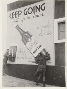
Photograph, A Mural West of Tobruk, 1941
A photo of a mural in Libya painted by a South Australian Sapper of a bottle of Abbots Lager. The photo, and two others, were sent to Melbourne Legacy in 1979 by Legatee Syd Wilson of Yamba NSW. He thought Melbourne Legacy might be able to use them to generate money by selling them for advertising or publicity. He said they were enlargements of snapshots he had found in his old army trunk. The text says 'Keep Going. Fill up in town, but a good drink is bloody hard to get'. Legatee Wilson's letter says the murals were: 'painted on three walls of a white concrete Italian block house (Police Check post I think), some 18/20 miles west of Tobruk, between Tobruk and Derna, and near a captured Italian airfield, somewhere about February 1941. Obviously they were painted by a Victorian Sapper. They were very well done, by a competent Sign-writer/artist, in correct and excellent colours (captured Itie paint no doubt - there was plenty in their Naval Stores at Tobruk).' (NB Itie was slang for Italian) From the AWM website the signs were painted by South Australian painter, SZ538 Sapper Leslie John “Doc” Dawes, 2/3rd Field Company, Royal Australian Engineers. There are several photos on the AWM site including the building the three murals were on.Photos taken by a Legatee when on active service in Libya in World War 2. They were donated to Legacy when it was thought they could be used for fundraising, which shows that Legatees were conscious of that Legacy needs to generate funds to continue its work.Black and white enlargement of a photo taken in Libya of Abbots Lager mural.tobruk, soldiers, lager, beer, abbots lager, murals -
 Melbourne Legacy
Photograph, A Mural West of Tobruk, 1941
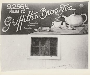
A photo of a mural in Libya painted by a South Australian Sapper of a tea pot saying '9,256 miles to Griffiths Bros Tea Headquarters, Melbourne'. The photo, and two others, were sent to Melbourne Legacy in 1979 by Legatee Syd Wilson of Yamba NSW. He thought Melbourne Legacy might be able to use them to generate money by selling them for advertising or publicity. He said they were enlargements of snapshots he had found in his old army trunk. The text says '9,256 miles to Griffiths Bros Tea Headquarters, Melbourne'. Legatee Wilson's letter says the murals were: 'painted on three walls of a white concrete Italian block house (Police Check post I think), some 18/20 miles west of Tobruk, between Tobruk and Derna, and near a captured Italian airfield, somewhere about February 1941. Obviously they were painted by a Victorian Sapper. They were very well done, by a competent Sign-writer/artist, in correct and excellent colours (captured Itie paint no doubt - there was plenty in their Naval Stores at Tobruk).' (NB Itie was slang for Italian) From the AWM website the signs were painted by South Australian painter, SZ538 Sapper Leslie John “Doc” Dawes, 2/3rd Field Company, Royal Australian Engineers. There are several photos on the AWM site including the building the three murals were on.Photos taken by a Legatee when on active service in Libya in World War 2. They were donated to Legacy when it was thought they could be used for fundraising, which shows that Legatees were conscious of that Legacy needs to generate funds to continue its work.Black and white enlargement of a photo taken in Libya of a Griffiths Tea mural.tobruk, tea, murals, world war two -
 Melbourne Legacy
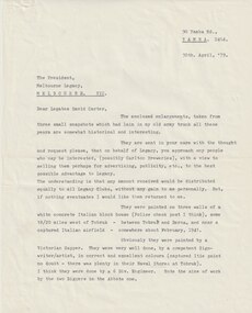
Letter, Tobruk Photos, 1979
Letters regarding three photos of murals in near Tobruk in Libya. The photos were sent to Melbourne Legacy in 1979 by Legatee Syd Wilson of Yamba NSW. He thought Melbourne Legacy might be able to use them to generate money by selling them for advertising or publicity. He said they were enlargements of snapshots he had found in his old army trunk. Legatee Wilson's letter says the murals were: 'painted on three walls of a white concrete Italian block house (Police Check post I think), some 18/20 miles west of Tobruk, between Tobruk and Derna, and near a captured Italian airfield, somewhere about February 1941. Obviously they were painted by a Victorian Sapper. They were very well done, by a competent Sign-writer/artist, in correct and excellent colours (captured Itie paint no doubt - there was plenty in their Naval Stores at Tobruk).' (NB Itie was slang for Italian) From the AWM website the signs were painted by South Australian painter, SZ538 Sapper Leslie John “Doc” Dawes, 2/3rd Field Company, Royal Australian Engineers. There are several photos on the AWM site including the building the three murals were on.Photos taken by a Legatee when on active service in Libya in World War 2 and donated to Legacy when it was thought they could be used for fundraising, which shows that Legatees were conscious of that Legacy needs to generate funds to continue its work.Black and white enlargement of a photo taken in Libya of Abbotts Lager mural.tobruk, murals -
 Melbourne Legacy
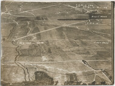
Photograph - Photo, Aerial view of the Somme
An aerial photo of the Somme in France during World War One. There are coordinates or numbers in some areas. Also labelled are the Johannes and Anvil Wood. Was with 11 other photos of World War One that had been mounted on board for display at Legacy House at some stage. When they were taken off display they were put in the archive cabinets. The founding legatees all served in World War One so these photos would have been of significant places for them. (see 01888 to 01899). From the AWM: Anvil Wood was a small wood to the north of Peronne that marked the centreline of an attack by the 14th Brigade on the morning of 1 September 1918. The northern approaches to Peronne were covered by numerous field and machine-guns, but the leading battalions of the brigade - the 53rd and 54th - pushed their attack home with determination, and sent the German defenders fleeing back to Peronne. The attack opened the way for the 14th Brigade to advance on to Peronne itself and break into the town's northern defences.Photos from World War One that would have been significant to the founding legatees.Sepia photo of the Somme battlefield in France during World War One.world war one, france, somme -
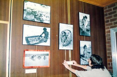 Eltham District Historical Society Inc
Photograph, Peter Bassett-Smith, Donald Thomson collection, 1988
Photo display relating to the work of Eltham anthropologist Professor Donald Thomson (1901-1970) who was renowned for his work researching Aborigines across Central Australia. Part of the Bicentennial/Heritage Week Display, "The Eltham Tradition", Eltham Shire Office, 17-22 April 1988. "The Photographic record which forms part of the Donald Thomson collection housed at the Museum of Victoria, by arrangement with the University of Melbourne contains 10,580 negatives. The collection also includes 5,700 artefacts and 4,500 pages of field notes. Cumbersome camera equipment and glass negatives often had to be carried hundreds of miles by pack horse, on small boars and other means. Three documentary films have been made, two by the BBC and released in over 18 countries and third, made by Academy of Science (1987) is for Year 12 Biology students. 28,000 feet of film record of Arnhem land was destroyed whilst in Commonwelath Government Custody." Two colour photographsactivities, eltham shire office, heritage display, heritage week, donald thomson, collection -
 Bendigo Military Museum
Photograph - 4 Fd Svy Sqn Closure Ceremony 25 Nov 1995, 4 Fd Svy Sqn, Keswick Barracks, Adelaide, 25.11.1995
Between 1915 and 1951, military topographical mapping in SA was conducted by Royal Australian Survey Corps (RASvy) units based outside the state. In February 1952, Army HQ Field Survey Section (Central Command Detachment) was established in Adelaide in a drill hall at Largs Bay. It was tasked with providing map coverage in the Woomera and Southern areas of the state. The section was subsequently reorganised as Central Command Field Survey Section moving firstly to Hampstead Barracks, Hampstead in 1953 and then into accommodation at Keswick Barracks in 1954. In 1957 the Section commenced mapping operations in the NT. The Unit was relocated to the old cavalry stables in 1961 and was redesignated Central Command Survey Unit and remained there till 1973. In 1970 the Unit was redesignated 4 Fd Svy Sqn and engaged in operations conducted in PNG from 1972 to 1974 inclusive. In 1973 the Squadron moved into a brand new two-storey specially designed and purpose built building adjacent to the old building. The old building then became the Squadron Q and Map store with an interconnecting lobby to the new building. Since 1975 the Unit was involved in the 1:50,000 Mapping Programme in WA, NT, QLD, SA and conducted many other operations within Australia and overseas. Post disbandment of the Corps the old Squadron building (cavalry stables) now houses the Army Museum of South Australia (AMOSA). The Royal Australian Survey Corps was amalgimated into the Royal Australian Engineer Corps in July 1996. In the lead up to this amalgamation, 4 Field Survey Squadron Keswick Barracks, Adelaide, South Australia was disbanded in 1995. A closing Ceremony was held on 25 November 1995 at 4 Fd Svy Sqn Keswick Barracks attended by about 208 former members of the Unit. A photo was taken of attendees at that event on the day and a list was prepared of attendees. All attendees were sent a copy of the photograph and the list of names as a momento of the Unit and the ceremony..1P A4 Print of an original photo of attendees at the 4 Fd Survey Sqn Closure Ceremony at Keswick Barracks 25 Nov 1995. .2P A4 Print of the names of the attendees at the 4 Fd Survey Sqn Closure Ceremony at Keswick Barracks 25 Nov 1995. Approx 208 attendees.royal australian survey corps, rasvy, fortuna, army survey regiment, army svy regt, asr, 4 fd svy sqn -
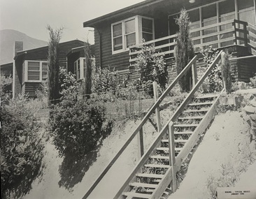 Falls Creek Historical Society
Photograph - Bogong Alpine Village Houses 1946
The images in the Bogong Village Collection were displayed in Bogong Jack’s Tavern for over 20 years and were donated to the Falls Creek Museum when the Tavern closed in 2021. In 1939, the State Electricity Commission of Victoria established a field headquarters at Bogong to house workers and their families for the Kiewa Hydroelectric Scheme which ran from the 1930s to the 1960s. The workmen's camp was originally started with tents and was called Junction Camp. By 1947, the village supported 300 workers and their families. It included 40 houses, a hostel for single staff, a post office, a police station, a medical centre, and a primary school. The staff hostel was known as Kiewa House. At the completion of the Scheme, in the 1960s, the village was opened to public/tourism use. In 1968 the Victorian Education Department acquired the camp buildings and four houses from the State Electricity Commission of Victoria to establish an Outdoor Education Centre which operated for over 50 years. The Kiewa Hydroelectric Scheme was privatized in the 1990s and sold to Southern Hydro, before being acquired by AGL in 2005. In 2023 the Grollo Group signed a 73 year sublease on Bogong Village and has plans for its redevelopment as a workers’ village.These images are significant because they capture the development of Bogong Village as an important element of the Kiewa Hydroelectric Scheme in Victoria.Two black and white images featuring houses in Bogong Village in January 1946. They are constructed of weatherboard, with brick chimneys and tin roofs. Timber steps lead up to the front door and a garden has been planted in front of the house.bogong alpine village, bogong high plains, bogong houses 1946 -
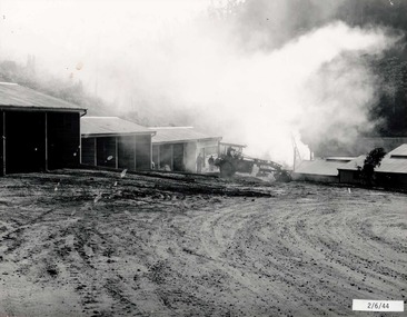 Falls Creek Historical Society
Photograph - Bogong Alpine Village 1944
The images in the Bogong Village Collection were displayed in Bogong Jack’s Tavern for over 20 years and were donated to the Falls Creek Museum when the Tavern closed in 2021. In 1939, the State Electricity Commission of Victoria established a field headquarters at Bogong to house workers and their families for the Kiewa Hydroelectric Scheme which ran from the 1930s to the 1960s. The workmen's camp was originally started with tents and was called Junction Camp. By 1947, the village supported 300 workers and their families. It included 40 houses, a hostel for single staff, a post office, a police station, a medical centre, and a primary school. The staff hostel was known as Kiewa House. At the completion of the Scheme, in the 1960s, the village was opened to public/tourism use. In 1968 the Victorian Education Department acquired the camp buildings and four houses from the State Electricity Commission of Victoria to establish an Outdoor Education Centre which operated for over 50 years. The Kiewa Hydroelectric Scheme was privatized in the 1990s and sold to Southern Hydro, before being acquired by AGL in 2005. In 2023 the Grollo Group signed a 73 year sublease on Bogong Village and has plans for its redevelopment as a workers’ village.These images are significant because they capture the development of Bogong Village as an important element of the Kiewa Hydroelectric Scheme in Victoria.A collection of four black and white images capturing the weather conditions in the Bogong area in June 1944bogong alpine village, bogong high plains, bogong june 1944 -
 Falls Creek Historical Society
Photograph - Bogong Alpine Village 1947
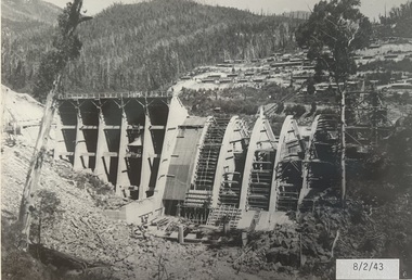
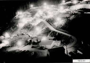
The images in the Bogong Village Collection were displayed in Bogong Jack’s Tavern for over 20 years and were donated to the Falls Creek Museum when the Tavern closed in 2021. In 1939, the State Electricity Commission of Victoria established a field headquarters at Bogong to house workers and their families for the Kiewa Hydroelectric Scheme which ran from the 1930s to the 1960s. The workmen's camp was originally started with tents and was called Junction Camp. By 1947, the village supported 300 workers and their families. It included 40 houses, a hostel for single staff, a post office, a police station, a medical centre, and a primary school. The staff hostel was known as Kiewa House. At the completion of the Scheme, in the 1960s, the village was opened to public/tourism use. In 1968 the Victorian Education Department acquired the camp buildings and four houses from the State Electricity Commission of Victoria to establish an Outdoor Education Centre which operated for over 50 years. The Kiewa Hydroelectric Scheme was privatized in the 1990s and sold to Southern Hydro, before being acquired by AGL in 2005. In 2023 the Grollo Group signed a 73 year sublease on Bogong Village and has plans for its redevelopment as a workers’ village.These images are significant because they capture the development of Bogong Village as an important element of the Kiewa Hydroelectric Scheme in Victoria.Two black and white images capturing Bogong Village by night and the spillway at Junction Dam.bogong alpine village, bogong high plains, bogong 1947 -
 Falls Creek Historical Society
Photograph - Jack Maddison Leading horses on the Bogong High Plain
The images in the Bogong Village Collection were displayed in Bogong Jack’s Tavern for over 20 years and were donated to the Falls Creek Museum when the Tavern closed in 2021. In 1939, the State Electricity Commission of Victoria established a field headquarters at Bogong to house workers and their families for the Kiewa Hydroelectric Scheme which ran from the 1930s to the 1960s. The workmen's camp was originally started with tents and was called Junction Camp. By 1947, the village supported 300 workers and their families. It included 40 houses, a hostel for single staff, a post office, a police station, a medical centre, and a primary school. The staff hostel was known as Kiewa House. At the completion of the Scheme, in the 1960s, the village was opened to public/tourism use. In 1968 the Victorian Education Department acquired the camp buildings and four houses from the State Electricity Commission of Victoria to establish an Outdoor Education Centre which operated for over 50 years. The Kiewa Hydroelectric Scheme was privatized in the 1990s and sold to Southern Hydro, before being acquired by AGL in 2005. In 2023 the Grollo Group signed a 73 year sublease on Bogong Village and has plans for its redevelopment as a workers’ village. John Maddison and his wife Mary Padman emigrated from London to Australia in 1850 with their five sons. Jack (John James William Maddison) was one of their great grandsons. In 1877 Jack’s grandfather George Maddison selected land between the East and West Kiewa branches of the Kiewa River - known as the "Island". It is now known as Mount Beauty. The Maddison family built Aertex Hut at the top of T Spur at Mt. Bogong for use when grazing cattle. It later became known as Maddison's Hut. Staircase Spur walking track at Bogong was formerly known as Maddison’s Track as it is the path once used by the Maddison family to drive their cattle on to the high plains. These images are significant because they feature the son of a pioneering family on the Bogong High Plains.A black and white photograph of Jack Maddison leading horses on the Bogong High Plains.bogong alpine village, bogong high plains, maddison family mt beauty, maddison's hut, aertex hut, -
 Falls Creek Historical Society
Photograph - Bogong Alpine Village and Howman's Dam Camp 1948
The images in the Bogong Village Collection were displayed in Bogong Jack’s Tavern for over 20 years and were donated to the Falls Creek Museum when the Tavern closed in 2021. In 1939, the State Electricity Commission of Victoria established a field headquarters at Bogong to house workers and their families for the Kiewa Hydroelectric Scheme which ran from the 1930s to the 1960s. The workmen's camp was originally started with tents and was called Junction Camp. By 1947, the village supported 300 workers and their families. It included 40 houses, a hostel for single staff, a post office, a police station, a medical centre, and a primary school. The staff hostel was known as Kiewa House. At the completion of the Scheme, in the 1960s, the village was opened to public/tourism use. In 1968 the Victorian Education Department acquired the camp buildings and four houses from the State Electricity Commission of Victoria to establish an Outdoor Education Centre which operated for over 50 years. The Kiewa Hydroelectric Scheme was privatized in the 1990s and sold to Southern Hydro, before being acquired by AGL in 2005. In 2023 the Grollo Group signed a 73 year sublease on Bogong Village and has plans for its redevelopment as a workers’ village.These images are significant because they capture the development of Bogong Village as an important element of the Kiewa Hydroelectric Scheme in Victoria.Two images capturing the depiction Bogong Village and the Howman's Dam Camp 1948bogong alpine village, bogong high plains, bogong 1947 -
 Falls Creek Historical Society
Photograph - Aerial View of Bogong Alpine Village
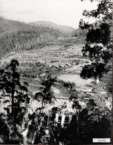
The images in the Bogong Village Collection were displayed in Bogong Jack’s Tavern for over 20 years and were donated to the Falls Creek Museum when the Tavern closed in 2021. In 1939, the State Electricity Commission of Victoria established a field headquarters at Bogong to house workers and their families for the Kiewa Hydroelectric Scheme which ran from the 1930s to the 1960s. The workmen's camp was originally started with tents and was called Junction Camp. By 1947, the village supported 300 workers and their families. It included 40 houses, a hostel for single staff, a post office, a police station, a medical centre, and a primary school. The staff hostel was known as Kiewa House. At the completion of the Scheme, in the 1960s, the village was opened to public/tourism use. In 1968 the Victorian Education Department acquired the camp buildings and four houses from the State Electricity Commission of Victoria to establish an Outdoor Education Centre which operated for over 50 years. The Kiewa Hydroelectric Scheme was privatized in the 1990s and sold to Southern Hydro, before being acquired by AGL in 2005. In 2023 the Grollo Group signed a 73 year sublease on Bogong Village and has plans for its redevelopment as a workers’ village.These images are significant because they capture the development of Bogong Village as an important element of the Kiewa Hydroelectric Scheme in Victoria.An aerial view of Bogong Village and surrounds, date unknown.bogong alpine village, bogong high plains, aerial photos bogong village -
 Falls Creek Historical Society
Photograph - Bogong Alpine Village 1940
The images in the Bogong Village Collection were displayed in Bogong Jack’s Tavern for over 20 years and were donated to the Falls Creek Museum by the Liz Krien & the Bogong Village Trust Board when the Tavern closed in 2021. In 1939, the State Electricity Commission of Victoria established a field headquarters at Bogong to house workers and their families for the Kiewa Hydroelectric Scheme which ran from the 1930s to the 1960s. The workmen's camp was originally started with tents and was called Junction Camp. By 1947, the village supported 300 workers and their families. It included 40 houses, a hostel for single staff, a post office, a police station, a medical centre, and a primary school. The staff hostel was known as Kiewa House. At the completion of the Scheme, in the 1960s, the village was opened to public/tourism use. In 1968 the Victorian Education Department acquired the camp buildings and four houses from the State Electricity Commission of Victoria to establish an Outdoor Education Centre which operated for over 50 years. The Kiewa Hydroelectric Scheme was privatized in the 1990s and sold to Southern Hydro, before being acquired by AGL in 2005. In 2023 the Grollo Group signed a 73 year sublease on Bogong Village and has plans for its redevelopment as a workers’ village.These images are significant because they capture the development of Bogong Village as an important element of the Kiewa Hydroelectric Scheme in Victoria.A collection of 10 black and white images capturing the development of Bogong Alpine Village. They depict development of the new village, the surrounding area and some staff members during 1940.bogong alpine village, bogong 1940, bogong high plains -
 Falls Creek Historical Society
Photograph - Bogong Alpine Village 1943
The images in the Bogong Village Collection were displayed in Bogong Jack’s Tavern for over 20 years and were donated to the Falls Creek Museum when the Tavern closed in 2021. In 1939, the State Electricity Commission of Victoria established a field headquarters at Bogong to house workers and their families for the Kiewa Hydroelectric Scheme which ran from the 1930s to the 1960s. The workmen's camp was originally started with tents and was called Junction Camp. By 1947, the village supported 300 workers and their families. It included 40 houses, a hostel for single staff, a post office, a police station, a medical centre, and a primary school. The staff hostel was known as Kiewa House. At the completion of the Scheme, in the 1960s, the village was opened to public/tourism use. In 1968 the Victorian Education Department acquired the camp buildings and four houses from the State Electricity Commission of Victoria to establish an Outdoor Education Centre which operated for over 50 years. The Kiewa Hydroelectric Scheme was privatized in the 1990s and sold to Southern Hydro, before being acquired by AGL in 2005. In 2023 the Grollo Group signed a 73 year sublease on Bogong Village and has plans for its redevelopment as a workers’ village.These images are significant because they capture the development of Bogong Village as an important element of the Kiewa Hydroelectric Scheme in Victoria.A collection of seven black and white images capturing the development of Bogong Alpine Village and the Pretty Valley area during 1943.bogong alpine village, bogong high plains, bogong 1943 -
 Falls Creek Historical Society
Photograph - Bogong Alpine Village 1942
The images in the Bogong Village Collection were displayed in Bogong Jack’s Tavern for over 20 years and were donated to the Falls Creek Museum when the Tavern closed in 2021. In 1939, the State Electricity Commission of Victoria established a field headquarters at Bogong to house workers and their families for the Kiewa Hydroelectric Scheme which ran from the 1930s to the 1960s. The workmen's camp was originally started with tents and was called Junction Camp. By 1947, the village supported 300 workers and their families. It included 40 houses, a hostel for single staff, a post office, a police station, a medical centre, and a primary school. The staff hostel was known as Kiewa House. At the completion of the Scheme, in the 1960s, the village was opened to public/tourism use. In 1968 the Victorian Education Department acquired the camp buildings and four houses from the State Electricity Commission of Victoria to establish an Outdoor Education Centre which operated for over 50 years. The Kiewa Hydroelectric Scheme was privatized in the 1990s and sold to Southern Hydro, before being acquired by AGL in 2005. In 2023 the Grollo Group signed a 73 year sublease on Bogong Village and has plans for its redevelopment as a workers’ village.These images are significant because they capture the development of Bogong Village as an important element of the Kiewa Hydroelectric Scheme in Victoria.A collection of four black and white images capturing the development of Bogong Alpine Village and the Pretty Valley area during 1942.bogong alpine village, bogong high plains, bogong 1942 -
 Falls Creek Historical Society
Photograph - Bogong Alpine Village 1941
The images in the Bogong Village Collection were displayed in Bogong Jack’s Tavern for over 20 years and were donated to the Falls Creek Museum when the Tavern closed in 2021. In 1939, the State Electricity Commission of Victoria established a field headquarters at Bogong to house workers and their families for the Kiewa Hydroelectric Scheme which ran from the 1930s to the 1960s. The workmen's camp was originally started with tents and was called Junction Camp. By 1947, the village supported 300 workers and their families. It included 40 houses, a hostel for single staff, a post office, a police station, a medical centre, and a primary school. The staff hostel was known as Kiewa House. At the completion of the Scheme, in the 1960s, the village was opened to public/tourism use. In 1968 the Victorian Education Department acquired the camp buildings and four houses from the State Electricity Commission of Victoria to establish an Outdoor Education Centre which operated for over 50 years. The Kiewa Hydroelectric Scheme was privatized in the 1990s and sold to Southern Hydro, before being acquired by AGL in 2005. In 2023 the Grollo Group signed a 73 year sublease on Bogong Village and has plans for its redevelopment as a workers’ village.These images are significant because they capture the development of Bogong Village as an important element of the Kiewa Hydroelectric Scheme in Victoria.A collection of four black and white images capturing the development of Bogong Alpine Village. They depict development of the new village, the surrounding area and some staff members during 1941.bogong alpine village, bogong high plains, bogong 1941 -
 Eltham District Historical Society Inc
Photograph - Digital Photograph, Alan King, Sweeney's Cottage, Sweeneys Lane, Eltham, 30 January 2008
Part of the original cottage named Culla Hill built by Thomas Sweeney (a former convict) remains as a small section of today’s house. Covered under Heritage Overlay, Nillumbik Planning Scheme National Estate National Trust of Australia (Victoria) Local Sifgnificance Published: Nillumbik Now and Then / Marguerite Marshall 2008; photographs Alan King with Marguerite Marshall.; p19 Thomas Sweeney, a former convict who became a respected citizen, once lived on a property at what is now the corner of Sweeneys Lane and Culla Hill, Eltham. As Sweeney was one of the district’s first settlers, the property is registered by the National Trust. Thomas Sweeney was born in 1802, son of impoverished tenant farmers in Tipperary County, Ireland. He became a ploughman, then at 21 he was sentenced to hang for setting on fire the house of Patrick Guyder at Gullshill. It is said the arson was due to a dispute over undelivered guns to a social justice guerilla group, the White Boys, of which Sweeney was a member. But the sentence was commuted to life transportation to Australia in 1823.1 Apparently in Sydney he became a servant to James Chandler at Botany. Soon James Chandler leased his farm and became a catechist on the Hawkesbury River, so Sweeney was reassigned to a former convict, John Brown, at Liverpool. Later Sweeney was assigned to George Brown of Lake Illawarra. In 1831, Sweeney was granted a ticket-of-leave and bought a boat to carry goods between Illawarra district and Sydney Town. He married his first wife who had come to Australia as a free woman. However she drowned after bearing him a daughter. In 1838, one month after he had received a conditional pardon, Sweeney married a blacksmith’s daughter, Margaret Meehan, newly arrived from Ireland. They then moved to Port Phillip and squatted on the south side of the Yarra River, about seven miles (11km) from Melbourne. Around 1842, Sweeney bought 110 acres (44.5ha) in the parish of Nillumbik for £110. He built a slab hut 12 x 10 feet (3.6m x 3m) and then his homestead, Culla Hill, a typical Tipperary style cottage, now known as Sweeney’s Cottage. It was here that many generations of Sweeneys lived for almost 100 years. Culla Hill became a social centre for the district and the Catholic community used it as a church. Sweeney was apparently on good terms with a tribe of Aborigines living on the river nearby, who helped him build his house.2 Sweeney proved himself a civic-minded leader. In 1844, he led a call for a bridge over the Plenty River. He was on the first school board and supplied the first grain for Eltham’s mill. Sweeney profited during the gold rush, not by gold digging, but by providing supplies for nearby fields and others as far away as Beechworth.3 Thomas Sweeney died in 1867 and was buried at the Eltham Cemetery, leaving two sons, five daughters, and 300 acres (121.4ha), as well as Culla Hill. Culla Hill – by then reduced to 75 acres (30ha) – was sold out of the family in 1939, then renamed Sweeneys. The present Sweeneys Lane, running diagonally through the original holding, was the track to the house. Part of the original cottage remains as a small section of today’s house. The dining-family room fronted by a veranda is original, and although there have been some changes, the cedar door and most of the small 12-paned wooden-framed windows are original. The walls are made of the original hand-made brick. After buying the property in 1952 Mr and Mrs Burston demolished a dilapidated slab hut, a three-roomed detached kitchen and cellar, as materials needed to restore them were very difficult to obtain so soon after the war.4 However the barn remains almost in its original condition. It is believed to have been built from stone quarried on the property. Now roofed with iron sheets it was probably originally thatched. The sandstone barn has a peaked roof supported by the original saplings and a doorway large enough to accommodate a fully loaded wagon.This collection of almost 130 photos about places and people within the Shire of Nillumbik, an urban and rural municipality in Melbourne's north, contributes to an understanding of the history of the Shire. Published in 2008 immediately prior to the Black Saturday bushfires of February 7, 2009, it documents sites that were impacted, and in some cases destroyed by the fires. It includes photographs taken especially for the publication, creating a unique time capsule representing the Shire in the early 21st century. It remains the most recent comprehenesive publication devoted to the Shire's history connecting local residents to the past. nillumbik now and then (marshall-king) collection, culla hill, eltham, sweeney's cottage, sweeneys lane, thomas sweeney -
 Eltham District Historical Society Inc
Photograph - Digital Photograph, Marguerite Marshall, 'Worlingworth', 10-26 Banoon Road, Eltham, 30 January 2006
'Worlingworth', Eltham, home of noted anthropologist the late Professor Donald Thomson and his wife Dorita Thomson. Covered under Heritage Overlay, Nillumbik Planning Scheme. Published: Nillumbik Now and Then / Marguerite Marshall 2008; photographs Alan King with Marguerite Marshall.; p127 Dubbed as ‘Australia’s Lawrence of Arabia’ anthropologist Donald Thomson lived much of his life in Eltham, at Banoon Road. On his retirement as Professor of Anthropology in 1968, The University of Melbourne professorial board compared Thomson to Lawrence of Arabia because of his work for Aborigines and his controversial personality. Although Thomson is now recognised for his huge contribution, during his lifetime he suffered opposition and his life has been described as ‘tragic’.1 Thomson failed to gain the recognition as a scientist that he felt he deserved and he failed to alter government policy towards Aboriginal people. But towards the end of his life in 1970, anthropologists were moving towards the type of research he had done and the movement to grant land rights to Aborigines was strengthening. Thomson is best known for his anthropological fieldwork in Cape York, Arnhem Land and Central Australia, but he is also known for his scholarly contributions to ornithology and ecology. Thomson documented every aspect of the daily and ritual life of the Aboriginal world of Cape York and Arnhem Land in the 1930s and 1940s. The huge collection in Museum Victoria includes 11,000 photographs, 7500 items of material culture, 1000 botanical and zoological specimens and 4500 pages of field-notes.2 The film Ten Canoes used Thomson’s photographs as a source. Thomson bought the Eltham property known as Worlingworth in 1934. The single-storey 60-square house standing by the Yarra River was built in 1922-23. It is one of the last in Eltham to survive with its farm setting intact. It is also one of the few substantial residences built in the Eltham Shire from the late 19th century to the early 20th century, which signalled a major change in the area towards the residential municipality it is today.3 The original section, built in the mid 1860s, of rose pink hand-made bricks and stone quarried on the property, was incorporated in the new red-brick house built in 1922. An immense oak tree by the house grew from an acorn brought by Patrick Armstrong who first bought the land in March 14, 1862. Armstrong named Worlingworth after his forbears’ village in Suffolk, England. Worlingworth saw grand days when Commander Alan A Barlee (R.N.) bought it in 1922 after winning the Calcutta Sweep. The property then included a nine-hole golf course, a tennis court, a bowling green, a boathouse and a boat-ramp.4 For most of his career Thomson, who was born in 1901, was attached to The University of Melbourne. In 1935 he represented the Commonwealth Government at Caledon Bay in east Arnhem Land to investigate and mediate for four Aborigines accused of killing five Japanese and three Europeans. In 1938 Thomson was awarded a PhD in Anthropology at Cambridge University, and during his career, he received several medals from British Societies, who perhaps appreciated his work better than their Australian counterparts. From World War Two, Thomson suffered a string of hardships, beginning with severe wounding in Dutch New Guinea (for his military service in New Guinea he was awarded an OBE) and he was invalided from service in 1944. That year he was diagnosed with diabetes. A fire in 1946 destroyed what Thomson regarded as perhaps the best record he had made of Aboriginal life – the 20,000 feet, (6096m) of film he had shot in Arnhem Land. In 1954 he and wife, Gladys, divorced. The next year he married his technical assistant, Dorita McColl. Several times during his career Thomson had major disagreements. For instance Professor P Elkin constantly opposed his work. He also opposed Thomson when he campaigned vigorously in 1947 against the establishment of a rocket range at Woomera, South Australia, because of the threat it posed Aborigines. Thomson resigned in frustration from the Victorian Aborigines Welfare Board in 1967, after serving for ten years, because he found that his advice was disregarded. His ashes were scattered over Caledon Bay from the air.This collection of almost 130 photos about places and people within the Shire of Nillumbik, an urban and rural municipality in Melbourne's north, contributes to an understanding of the history of the Shire. Published in 2008 immediately prior to the Black Saturday bushfires of February 7, 2009, it documents sites that were impacted, and in some cases destroyed by the fires. It includes photographs taken especially for the publication, creating a unique time capsule representing the Shire in the early 21st century. It remains the most recent comprehenesive publication devoted to the Shire's history connecting local residents to the past. nillumbik now and then (marshall-king) collection, banoon road, donald thomson, dorita thomson, eltham, worlingworth