Showing 1947 items matching "floods"
-
 Glenelg Shire Council Cultural Collection
Map - Map - Glenelg River, 1975
Laminated map, Glenelg River - Casterton, proposed flood level and lines to be designated. Photograph of map taken in 1975. Produced by Rural Water Commission to Shire Engineer, Casterton, attached to reverse of map.flood, flood levels, casterton -
 Victoria Police Museum
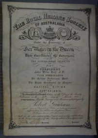
Certificate and Scroll (Robert Graham), 1888
Black embossed leather scroll with printed and handwritten Royal Humane Society Award Certificate awarded to Robert Graham for rescuing sufferers from the flood at the Goulburn River at Shepparton on 7th November 1887robert graham, greta, kelly gang, ellen kelly, royal humane society, bravery, awards, shepparton -
 Marysville & District Historical Society
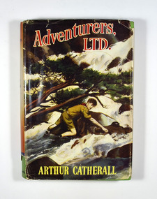
Book, Arthur Catherall, Adventurers, Ltd, 1954
Adventurers, Ltd., was a band of Scouts, all tip-top chaps. they liked to challenge Scouts in neighbouring towns-just to see how good they were. Not one of the Associations they visited ever succeeded in beating Andy, Sam Dodds, Smithy, Fatty Leadfield and the rest, but some of the adventures that came along in the process nearly did! Andy and the haunted tower, for instance; and Dickie Goole and the crashed pilot on the mountain; and the dangerous adventure of the two men in the quicksand. Another first-rate Scouting story by this favourite author.Dust cover has an illustration of a boy scout attempting to cross a flooded river. The reverse of the dust cover has information regarding The Crown Library; a series of school and adventure books for boys and girls.fictionAdventurers, Ltd., was a band of Scouts, all tip-top chaps. they liked to challenge Scouts in neighbouring towns-just to see how good they were. Not one of the Associations they visited ever succeeded in beating Andy, Sam Dodds, Smithy, Fatty Leadfield and the rest, but some of the adventures that came along in the process nearly did! Andy and the haunted tower, for instance; and Dickie Goole and the crashed pilot on the mountain; and the dangerous adventure of the two men in the quicksand. Another first-rate Scouting story by this favourite author.scouts, adventure, arthur catherall, fiction -
Tatura Irrigation & Wartime Camps Museum
Newspapers re/ local floods 1974, McPherson's Printing Group, Victoria, Tatura Guardian & Shepparton News, May 1974
Detailed history of 1974 floods in Shepparton and Mooroopna.Tatura Guardian 22 May 1974. Shepparton News 17th & 18th May 1974. Relating to record floods in the Goulburn River affecting Shepparton, Mooroopna, and Undera and to a lesser degree Tatura and Merrigum.record floods mooroopna & shepparton -
 Sunshine and District Historical Society Incorporated
Photograph (1954) - Flooded Bridge, 1954
1954 Photograph of KOROROIT CREEK in flood and overflowing the DERBY RD BRIDGE in Sunshine. Short time later this bridge was declared unsafe and closed to vehicle traffic. The Sunshine Technical School building is in the background.derby rd bridge, flood, kororoit creek, sunshine technical school, 1954 -
 Wodonga & District Historical Society Inc
Album - Hume Reservoir Australia Album - Foundations for core wall of earth embankment, September 1921
This set of photos is from a leather bound album bearing the inscription "HUME RESERVOIR AUSTRALIA" plus 'The Rt. Hon. L. C. M. S. Amery, P. C., M .P.' all inscribed in gold. It was presented to The Rt. Hon. L. C. M. S. Amery, P. C., M. P, Secretary of State for Dominion Affairs on the occasion of his visit to the Hume Reservoir on 2nd November 1927. This album is of local and national significance as it documents the planning and development of the Hume Reservoir up to 1927. It was the largest water reservoir in the British Empire. The album records the pioneering engineering work that went into its construction.DEPARTMENT OF PUBLIC WORKS, N.S.W. RIVER MURRAY WATERS SCHEME. HUME RESERVOIR. 5. Foundations for core wall of earth embankment in New South Wales in September 1921. The River Murray in flood.hume reservoir australia, river murray waters scheme, hume weir diagrams, hume plan details -
 Eltham District Historical Society Inc
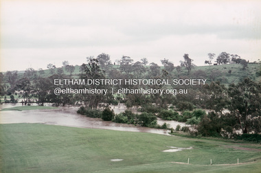
Slide, Floodwater, west from Clubhouse of Rosanna Golf Club, Lower Plenty, November 1971, 1971
Many parts of Melbourne flooded including Rosanna Golf Club, Lower Plenty in Novembere 1971. Many surburban roads, including the new south-eastern freeway were cut by flood waters. Here the level of the Plenty River floods onto the golf course. 35 mm colour positive transparency Mount - Agfacolor Service (Blue)floods, lower plenty, rosanna golf club, flooding, plenty river -
 Eltham District Historical Society Inc
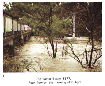
Work on paper (Sub-Item) - Photograph, Main Road Bridge, Eltham peak flow of flood 8 April, 1977
Colour photograph. Flooding of Diamond Creek at Main Road Bridge, Eltham peak flow of flood. Easter storm, 8 April, 1977flood, diamond creek, flooding, eltham, bridge, main road -
 Charlton Golden Grains Museum Inc
Photograph, Cameron, Ian, 01/02/1973
Taken by the editor of The Charlton Tribune Ian Cameron. Of the 1973 flood at Gordon Park and Croquet Club. Highest flood since 1956, 25 feet 1 1/2 at the bridge, 4 inches of rain fell in the catchment. Road damage after the flood was estimated to be $74,800.Large sepia photograph unframed, creased in top RH corner, surface torn on left edge. Unmountedflood, gordon park, croquet club, charlton -
 Bendigo Historical Society Inc.
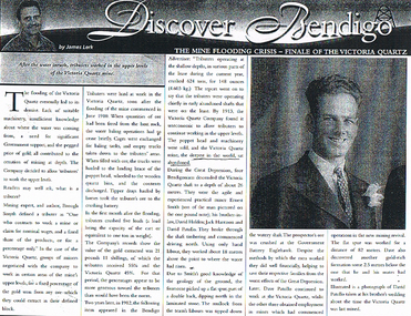
Document - LONG GULLY HISTORY GROUP COLLECTION: THE MINE FLOODING CRISIS - FINALE OF THE VICTORIA QUARTZ
BHS CollectionPhotocopy of a newspaper article titled Discover Bendigo by James Lerk titled The Mine Flooding Crisis - Finale of the Victoria Quartz. Soon after the flooding of the mine commenced in June 1910, tributers worked the upper levels. By 1913 the Company found it was uneconomic to allow tributers to continue working in the upper levels. Four Bendigo men, Ernest Smith, David Holden, Jack Harrison and David Patullo worked the mine during the Depression. They did well. A photo of David Patullo is in the article.bendigo, history, long gully history group, the long gully history group - the mine flooding crisis - finale of the victoria quartz, james lerk, victria quartz, brough smyth, bendigo advertiser 1912, great depression, ernest smith, david holden, jack harrison, david patullo, government battery eaglehawk -
Glenelg Shire Council Cultural Collection
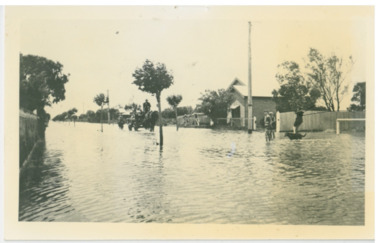
Photograph - Photograph reprint of scan of photograph - Flood August 1909, Casterton, Victoria, n.d
Vern McCallum CollectionReprint of scan of black and white photograph. Image show's Henty Street Casterton, flooded. Group of men on right standing in streets in ankle deep water. Print mounted on white archival mountboard frame. -
 Chelsea & District Historical Society Inc
Photograph - Chelsea Flood December 1934, Argyle Avenue, Chelsea
In December 1934, 700 houses were inundated with water, when the Dandenong Creek and Patterson River broke their banks.Black and white photo boys playing in the flood waters in Argyle Street, Chelsea, East of Fowler Street. Coming down the street is a horse pulling a cart with people on board, and a person on horse back following.flood, chelsea, dandenong creek, fowler street, argyle avenue, horse and cart -
 Orbost & District Historical Society
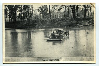
black and white photograph, late 19th century
A punt crossed the Snowy River at Orbost from 1884. A bridge was constructed in 1893, but was soon damaged by a huge flood. Flooding was a regular occurrence, the worst inundations being in 1870, 1893, 1925, 1934, 1952 and 1971. Over the years major flood protection works have been implemented. The Princes Highway, which passes Orbost, now crosses the flood plain on raised concrete supports. (info, from Victorian Places Orbost)This item is associated with the Snowy River and its history. It is a pictorial record of transport in the late 19th century.A black / white photograph (copy) of a punt loaded with people and a horse-drawn carriage making its way across a river.on front at bottom - "Snowy River Punt"snowy-river-orbost transport shipping -
 Ballarat Tramway Museum
Postcard - Set of 6 and background card, Ken Flood, "Launceston Municipal Tramways"
The Postcards show trams of Launceston which operated from 1911 to 1952, published by International Railway Postcards of Launceston. The background card gives a short history of Launceston trams and the reproduction of two tickets. 1 - Postcard 1 - No. 11 leads a line up of cars in Elphin Road - Ken Flood 6-3-1948 2 - No 27, Mumford St loop - Ken Flood - 9-10-1948 3 - No. 24 Wellington St, photo Ken Flood, 26-2-1949 4 - No. 9 turns from George St into Cameron St - 25-9-1948 - Photo Ken Flood 5 - No. 26 - Talbot Road terminus - 1-11-1948 - Ken Flood 6 - No. 9 Elphin Road, 13-10-1948 - Ken Flood Yields information about Launceston trams, the Museum having No 14 on display, No. 14 from 2022.Set of 6 black and white postcards and a story card. Each have a caption on the rear and a place for a stamp and address.launceston, tramways, tramcars -
 Orbost & District Historical Society
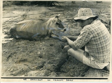
black and white photograph, 11 February 1971
This photograph was taken during the 1971 floods at Orbost. The 1971 flood was the the worst flood on record. At Jarrahmond it was at least 11 metres and up to one and a half kilometres wide on the flats causing enormous damage to the flood plain. Records say that "The brown floodwater stain in Bass Strait could be seen from passing airliners." Considerable damage was done to railway infrastructure, roads and farms. More information from the APRIL, 2008 newsletter by John Phillips. (see orbosthistory.com.au)This is a contemporary pictorial record of a significant local event.A large black / white photograph of a man, dressed in shorts and a checked shirt, sitting on a fence post surrounded by mud. He is holding on to the leg of a cow which is stuck in the mud.on front - "Mr Harrison on Tracey's Dairy" on back - " Herald 11 Feb 1971"floods-orbost-1971 tracey-dairy natural-disaster-flood -
 Bendigo Historical Society Inc.
Slide - FLEMING COLLECTION: 1950S BENDIGO SLIDE, 1950s
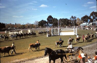
Bendigo 1950s. Bendigo Easter Procession. Easter Monday was 7 April 1958. View of the Bendigo Show Grounds (now Tom Flood Centre). Horses and cattle parading around the ring, horse and gig on the track.Kodachromeevent, easter fair, bendigo easter fair, bendigo 1950s. bendigo easter procession. easter monday was 7 april 1958. view of the bendigo show grounds (now tom flood centre). horses cattle parading ring, horse gig track -
 Bendigo Historical Society Inc.
Slide - FLEMING COLLECTION: 1950S BENDIGO SLIDE
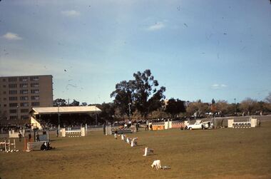
Bendigo 1950s. Bendigo Easter Procession. Easter Monday was 7 April 1958. Tom Flood Centre (formerly the Bendigo Show Grounds). Grand stand on Bethlehem side. On oval are horse jumps and white dogs. -
 Bendigo Historical Society Inc.
Newspaper - JENNY FOLEY COLLECTION: A DAY OUT
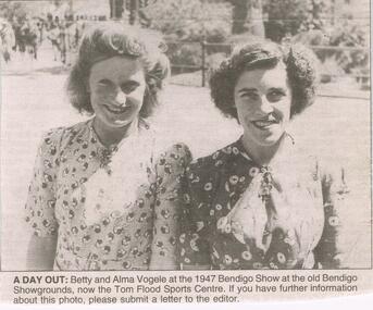
Bendigo Advertiser "The way we were" from Tuesday, September 28, 2004. A day out: Betty and Alma Vogele at the 1947 Bendigo Show at the old Bendigo Showgrounds, now the Tom Flood Sports Centre.newspaper, bendigo advertiser, the way we were -
Port Melbourne Historical & Preservation Society
Photograph - Flooded subway at North Port Station, Port Melbourne, 14 Feb 1955
Item appeared on the front page 14.02.1955. In 2002 emails relating to this were received from Sweden, from the child standing in underpants only in the foreground. Image is used in the 2003 Historic Port Melbourne calendar.Lasercopy from original Herald photograph of railway sub-way at North Port Station on Raglan Street in flood, 14 February 1955, showing children from nearby houses swimming in the floodwaters near the underpass.transport - railways, flood, sport - swimming, advertising, business and traders - hotels, sandra svensson nilsson, robert (bobby) farrell, ruth 'bubbles' farrell -
 Lakes Entrance Historical Society
Photograph, 2012
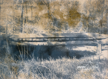
Date made December 2012Colour photograph of the railway bridge over Boggy Creek at Nowa Nowa. Bridge is built on combination of solid concrete piers, timber trestle piers on concrete to flood level, and timber piers. Nowa Nowa Victoriabridges, waterways, transport -
 Eltham District Historical Society Inc
Photograph, Mount Pleasant Road Bridge, Research, c.1977, 1977c
Various Flood Pictures.Black and white photographmount pleasant road bridge, research (vic.) -
 Eltham District Historical Society Inc
Photograph, Mount Pleasant Road Bridge, Research, c.1977, 1977c
Various Flood Pictures.Black and white photographmount pleasant road bridge, research (vic.) -
 Eltham District Historical Society Inc
Photograph, Mount Pleasant Road Bridge, Research, c.1977, 1977c
Various Flood Pictures.Black and white photographmount pleasant road bridge, research (vic.) -
 Eltham District Historical Society Inc
Photograph, Mount Pleasant Road Bridge, Research, c.1977, 1977c
Various Flood Pictures.Black and white photographmount pleasant road bridge, research (vic.) -
 Eltham District Historical Society Inc
Photograph, Mount Pleasant Road Bridge, Research, c.1977, 1977c
Various Flood Pictures.Black and white photographmount pleasant road bridge, research (vic.) -
 Eltham District Historical Society Inc
Photograph, Mount Pleasant Road Bridge, Research, c.1977, 1977c
Various Flood Pictures.Black and white photographmount pleasant road bridge, research (vic.) -
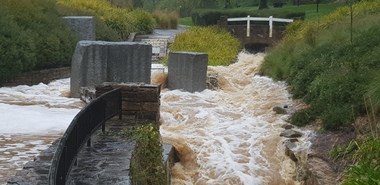 Ballarat Heritage Services
Photograph - Hepburn Mineral Springs flood 13 Oct 2022, LJ Gervasoni, Springs in flood 2022, 13 October 2022
October 2022 floodsjpg photolocarno, hepburn mineral springs reserve, wild cat creek -
 Ringwood and District Historical Society
Photograph, Bridge connecting Adelaide St. and Reynolds Av., Ringwood. pre 1931
Written on back of photograph, "Bridge connecting Adelaide St. and Reynolds Av. Washed away in 1931 by the flooded Mullum Creek. Looking towards Reynolds Ave." -
 Federation University Historical Collection
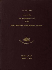
book, Truth & Sportsman Ltd, Souvenir commemorating the commencement of work by the Snowy mountains hydro-electric authority, 17/10/1949
It is assumed that a member of the Ballarat School of Mines attended the commencement of work at the Snowy Mountains hydro-electric centre.Burgundy cover with gold printing. Black print, photos and diagrams on white paper (31 pages). Bound by 3 staples. The contents include the story of the Snowy. Images include W.J. McKell, J.B. (Ben) Chifley, J. McGirr, Nelson Lemmon, Hume Weir, Jindabyne valley (now flooded), Jindabyne township (now flooded), illustration of water Power, survey team at Adaminaby, Snowy Mountains Relief Plan, Horseman crossing the Eucumbene River, Mildura, Burrinjuck Dam under construction, transmission lines, W. Hudson.snowy mountains hydro-electricty scheme, snowy mountains hydro-electric authority -
 Bendigo Historical Society Inc.
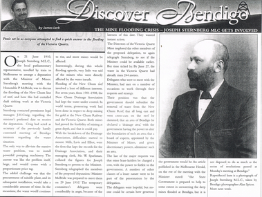
Newspaper - LONG GULLY HISTORY GROUP COLLECTION: THE MINE FLOODING CRISIS - VICTORIA QUARTZ
Copy of an article in the Bendigo Weekly titled The Mine Flooding Crisis - Joseph Sternberg MLC gets involved by James Lerk. Joseph Sternberg MLC travelled to Melbourne to arrange a deputation with the Minister of Mines to discuss the flooding of the New Chum line of reef. Pumping was mentioned but it would be expensive and would take time and the water would keep rising. They would also have to find a suitable pumping plant. The New Chum Drainage Association had kept the water under control. Delegates wanted the Government to subsidise the removal of the water.bendigo, history, long gully history group, the long gully history group - bendigo weekly, james lerk, victoria quartz, joseph sternberg, the honorable p mcbride, j h craig, new chum reef, new chum drainage association, new chum railway, mills lavis and elliot, mr w sparkman, melbourne herald, alan spicer