Showing 2936 items matching "park house"
-
 Eltham District Historical Society Inc
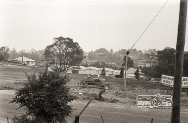
Photograph, Sherbourne Road, Para Road and Simms Road at Briar Hill, 3 November 1967, 3 Nov 1967
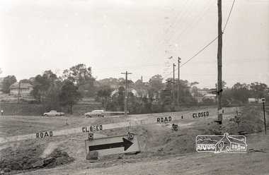
... , approximately where the two cars are parked. Mrs Cameron's house..., approximately where the two cars are parked. Mrs Cameron's house ...Viewed from eastern side of Para Road opposite Graham Body Works.. Simms Road is running to the right in front of the old house. The house belongs to Mrs Cameron whose daughter married a DAVEY after which Davey Street is named. Excavation work is being undertaken for the realignment of the Para Road and Sherbourne Road intersection where the current roundabout is located, approximately where the two cars are parked. Mrs Cameron's house and the other are where Montmorency Secondary College is situated. The school opened in 1969.Roll of 35mm black and white negative film, 6 strips Ilford HP3briar hill, cameron, davey, davey road, graham body works, greensborough, montmorency secondary college, sherbourne road, simms road, vw service -
 Eltham District Historical Society Inc
Photograph, Sherbourne Road, Para Road and Simms Road at Briar Hill, 3 November 1967, 3 Nov 1967
... , approximately where the two cars are parked. Mrs Cameron's house..., approximately where the two cars are parked. Mrs Cameron's house ...Viewed from eastern side of Para Road opposite Graham Body Works.. Simms Road is running to the right in front of the old house. The house belongs to Mrs Cameron whose daughter married a DAVEY after which Davey Street is named. Excavation work is being undertaken for the realignment of the Para Road and Sherbourne Road intersection where the current roundabout is located, approximately where the two cars are parked. Mrs Cameron's house and the other are where Montmorency Secondary College is situated. The school opened in 1969.Photostitch from multiple images on roll of film. Roll of 35mm black and white negative film, 6 strips Ilford HP3briar hill, cameron, davey, davey road, graham body works, greensborough, montmorency secondary college, sherbourne road, simms road, vw service -
 Eltham District Historical Society Inc
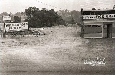
Photograph, Sherbourne Road, Para Road and Simms Road at Briar Hill, 3 November 1967, 3 Nov 1967
... , approximately where the two cars are parked. Mrs Cameron's house..., approximately where the two cars are parked. Mrs Cameron's house ...Viewed from eastern side of Para Road opposite Graham Body Works.. Simms Road is running to the right in front of the old house. The house belongs to Mrs Cameron whose daughter married a DAVEY after which Davey Street is named. Excavation work is being undertaken for the realignment of the Para Road and Sherbourne Road intersection where the current roundabout is located, approximately where the two cars are parked. Mrs Cameron's house and the other are where Montmorency Secondary College is situated. The school opened in 1969.Roll of 35mm black and white negative film, 6 strips Ilford HP3briar hill, cameron, davey, davey road, graham body works, greensborough, montmorency secondary college, sherbourne road, simms road, vw beetle, vw service -
 Eltham District Historical Society Inc
Photograph, Group from Brunswick ANA Lodge at Eltham, Nov. 1933
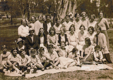
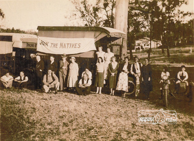
... Park, however the house in the background did not appear... Park, however the house in the background did not appear ...One of three photos. Group of people including children associated with the Australian Natives Association at an outing at Eltham Lower Park. The first image was reproduced in EDHS Newsletter No. 163 July 2005 following a query from Nillumbik Historical society (Gwen Myers) seeking information about the location of the photo. It was suggested that it may be Eltham Lower Park, however the house in the background did not appear correct. There were simliar but mirror imaged. A more recent review of these photographs (2023) suggests that the photos were actually taken in Bremners flats (present-day Wingrove Park) looking towards the house near the intersection of Main and Mount Pleasant roads - Mrs Bremner's house. The topograpghy is also more in fitting with this location than that of Eltham Lower Park. A review of a 1945 aerial photo shows only one house of similar style present in this location. Further reviews of photos taken in the 1950s ny Grace Mitchell looking back towards Bremner Flats shows two trees close by on a lean similar to that in the photos.Inkjet-printed copy of sepia photographaustralian natives association, bremners flats, recruitment, wingrove park -
 Eltham District Historical Society Inc
Photograph, Group from Brunswick ANA Lodge at Eltham, Nov. 1933
... . It was suggested that it may be Eltham Lower Park, however the house.... It was suggested that it may be Eltham Lower Park, however the house ...One of three photos. Group of people including children associated with the Australian Natives Association at an outing at Eltham. A truck displays a flag "Join the Natives". The first image was reproduced in EDHS Newsletter No. 163 July 2005 following a query from Nillumbik Historical society (Gwen Myers) seeking information about the location of the photo. It was suggested that it may be Eltham Lower Park, however the house in the background did not appear correct. There were simliar but mirror imaged. A more recent review of these photographs (2023) suggests that the photos were actually taken in Bremners flats (present-day Wingrove Park) looking towards the house near the intersection of Main and Mount Pleasant roads - Mrs Bremner's house. The topograpghy is also more in fitting with this location than that of Eltham Lower Park. A review of a 1945 aerial photo shows only one house of similar style present in this location. Further reviews of photos taken in the 1950s ny Grace Mitchell looking back towards Bremner Flats shows two trees close by on a lean similar to that in the photos. Inkjet-printed copy of sepia photographaustralian natives association, recruitment, bremners flats, wingrove park -
 Clunes Museum
Book, VICTORIAN MINISTRY FOR THE ARTS, THE OFFICIAL MUSEUMS DIRECTORY FOR VICTORIA
... -CM20. INCLUDED ARE: PUBLIC GALLERIES, HISTORIC HOUSES, HERITAGE..., HISTORIC HOUSES, HERITAGE PARKS, NATIONAL TRUST PROPERTIES ...THE MUSEUM'S ADVISORY BOARD OPERATES UNDER THEMUSUEMS ACT 1983 TO PROVIDE THE MINISTER WITH ADVICE ON THE DEELOPMENT OFMUSEUMS AND MSEUM SERVICES IN VICTORIA.1 PAPERBACK BOOK, GREEN COVER, PICTURE OF SPORT & OLYMPIC MUSEUM ON FRONT. PAGES, ROUND STICKER ON TOP RIGHT HAND CORNER -CM20. INCLUDED ARE: PUBLIC GALLERIES, HISTORIC HOUSES, HERITAGE PARKS, NATIONAL TRUST PROPERTIES, SCIENTIFIC COLLECTIONS AND HISTORICAL SOCIETY DISPLAYS, 217 PAGES .2 ADDENDUM AT 18/05/1990 ON OFF-WHITE PAPER (TRIFOLD)non-fictionTHE MUSEUM'S ADVISORY BOARD OPERATES UNDER THEMUSUEMS ACT 1983 TO PROVIDE THE MINISTER WITH ADVICE ON THE DEELOPMENT OFMUSEUMS AND MSEUM SERVICES IN VICTORIAmuseums directory, the official museums directory for victoria -
 Kew Historical Society Inc
Photograph, J F C Farquhar, Bird's Eye View Looking West, 1891
... west towards the rise of Studley Park. The houses... view extends west towards the rise of Studley Park. The houses ...At the beginning of the 1890s, the Kew businessman and Town Councillor, Henry Kellett, commissioned J.F.C. Farquhar to photograph scenes of Kew. These scenes included panoramas as well as pastoral scenes. The resulting set of twelve photographs was assembled in an album, Kew Where We Live, from which customers could select images for purchase.The preamble to the album describes that the photographs used the ‘argentic bromide’ process, now more commonly known as the gelatine silver process. This form of dry plate photography allowed for the negatives to be kept for weeks before processing, hence its value in landscape photography. The resulting images were considered to be finely grained and everlasting. Evidence of the success of Henry Kellett’s venture can be seen today, in that some of the photographs are held in national collections.It is believed that the Kew Historical Society’s copy of the Kellett album is unique and that the photographs in the book were the first copies taken from the original plates. It is the first and most important series of images produced about Kew. The individual images have proved essential in identifying buildings and places of heritage value in the district.Before true aerial photography became possible, photographers such as J.F.C. Farquhar were compelled to shoot their images from the highest vantage point. Here, it is presumed to be the roof of Xavier College, from which the panoramic view extends west towards the rise of Studley Park. The houses in the foreground face the southern end of Gellibrand Street. Wellington Street is at an angle to the camera with the Queen Street intersection on the near right. The wooden building behind the large horse paddock on the other side of Gellibrand Street is the Kew Recreation Hall, built 1888, demolished 1960. It was reputed to have one of the finest dancing floors in or around Melbourne. The Bowling Green at the rear of the Hall belonged to the Kew Bowling Club. Further west is the Kew Railway Station on Denmark Street, opened to the public in 1887. At this period, much of Studley Park was locked up in large landholdings, dominated by large mansions such as ‘Byram’. Bird's Eye View Looking Westkew illustrated, kew where we live, photographic books, henry kellett, denmark street, kew recreation hall, kew bowling club, wellington street -
 Eltham District Historical Society Inc
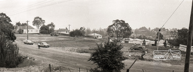
Photograph, Sherbourne Road, Para Road and Simms Road at Briar Hill, 3 November 1967, 3 Nov 1967
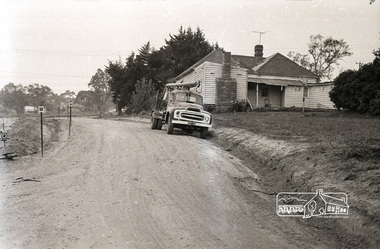
... Viewed from Simms Road in front of Mrs Cameron's house... melbourne Viewed from Simms Road in front of Mrs Cameron's house ...Viewed from Simms Road in front of Mrs Cameron's house in what is now the northwest bound lanes of Para Road prior to the roundabout intersedction with Sherbourne Road. Simms Road is running to the right in front of the old house. The house belongs to Mrs Cameron whose daughter married a DAVEY after which Davey Street is named. Excavation work is being undertaken for the realignment of the Para Road and Sherbourne Road intersection where the current roundabout is located, approximately where the two cars are parked. Mrs Cameron's house and the other are where Montmorency Secondary College is situated. The school opened in 1969.Roll of 35mm black and white negative film, 6 strips Ilford HP3briar hill, cameron, davey, davey road, graham body works, greensborough, montmorency secondary college, sherbourne road, simms road -
 Eltham District Historical Society Inc
Photograph, Sherbourne Road, Para Road and Simms Road at Briar Hill, 3 November 1967, 3 Nov 1967
... Viewed from Simms Road in front of Mrs Cameron's house... melbourne Viewed from Simms Road in front of Mrs Cameron's house ...Viewed from Simms Road in front of Mrs Cameron's house in what is now the northwest bound lanes of Para Road prior to the roundabout intersedction with Sherbourne Road. Simms Road is running to the right in front of the old house. The house belongs to Mrs Cameron whose daughter married a DAVEY after which Davey Street is named. Excavation work is being undertaken for the realignment of the Para Road and Sherbourne Road intersection where the current roundabout is located, approximately where the two cars are parked. Mrs Cameron's house and the other are where Montmorency Secondary College is situated. The school opened in 1969.Roll of 35mm black and white negative film, 6 strips Ilford HP3briar hill, cameron, davey, davey road, graham body works, greensborough, montmorency secondary college, sherbourne road, simms road -
 Linton and District Historical Society Inc
Photograph, Buildings, Sussex Street, Linton, 1988
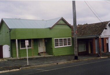
... for Maxwell Park C.E.B.S. camp. House had a later incarnation... for Maxwell Park C.E.B.S. camp. House had a later incarnation ...Photograph taken in 1988 of buildings in Sussex Street, Linton: house was previously Bill and Georgie Hall residence and before that a cake shop run by Stella Ralf (Stella Ralf also taught piano). Next to it can be seen the former Bennett garage building. Bennett shop and garage (petrol station) 1920s-1940s. Later (1970s-1981) run as op-shop by Mrs. Surman to raise money for Maxwell Park C.E.B.S. camp. House had a later incarnation as a laundromat in 1980s - at this time many women were still without electricity on outlying farms and house blocks.Colour photograph showing green painted timber house with pitched roof and small verandah, white trim, next to brick building with pitched roof and verandah over footpath, brick pillars. "Stella Ralph's old shop (cake) later Bennett garage"stella ralf, bennett's garage, stella surman, bill hall, georgina hall -
 Kew Historical Society Inc
Plan - Subdivision Plan, Windella-Darnley Subdivision, Studley Park, 1920s
... and Windella, both houses fronted Studley Park Road. Both houses appear... the subdivision of Darley and Windella, both houses fronted Studley Park ...Subdivision plans are historically important documents used as evidence of the growth of suburbs in Australia. They frequently provide information about when the land was sold on which a built structure was subsequently constructed as well as evidence relating to surveyors and real estate and financial agents. The numerous subdivision plans in the Kew Historical Society's collection represent working documents, ranging from the initial sketches made in planning a subdivision to printed plans on which auctioneers or agents listed the prices for which individual lots were sold. In a number of cases, the reverse of a subdivision plan in the collection includes a photograph of a house that was also for sale by the agent. These photographs provide significant heritage information relating house design and decoration, fencing and household gardens.Version 1 of two subdivision plans (the later one is MAP.0027) for the section of Studley Park Road near the Junction on the south side. Named in the subdivision are the mansions of Darley and Windella (now demolished). Before the subdivision of Darley and Windella, both houses fronted Studley Park Road. Both houses appear to be advertised as lots in the subdivision. Bisecting the subdivision is a street, Antrim Avenue that was never constructed. A street, which was subsequently constructed in this vicinity, was Merrion Place, which now runs between Studley Park Road and Highfield Grove. There are 14 proposed lots in this subdivision."Antrim Avenue. See over for new plan"subdivision plans - kew, studley park, windella, darnley, studley park road -- kew (vic.), merrion place -- kew (vic.), merrion grove -- kew (vic.), highbury grove -- kew (vic.) -
 Ringwood and District Historical Society
Photograph, Last remaining house on Eastland Shopping Centre site in Ringwood - 1985, 1985
... car park) 1985 shot 2. Ringwood - old house, Myer car park 3.... 1. Ringwood house (Myer car park) 1985 shot 2. Ringwood ...Photos (3) of the former McKinley home (Mayor 1927/28) and later Rymers' at 22 Adelaide Street, Ringwood, Victoria, 1985, prior to demolition for expansion of Eastland Shopping Centre. Covering letter from Connie White, 2014. 1. Ringwood house (Myer car park) 1985 shot 2. Ringwood - old house, Myer car park 3. Ringwood old house - Myer car park -
 Kew Historical Society Inc
Plan - Subdivision Plan, Windella-Darnley Subdivision, Studley Park, 1920s
... and Windella, both houses fronted Studley Park Road. Both houses appear... the subdivision of Darley and Windella, both houses fronted Studley Park ...Subdivision plans are historically important documents used as evidence of the growth of suburbs in Australia. They frequently provide information about when the land was sold on which a built structure was subsequently constructed as well as evidence relating to surveyors and real estate and financial agents. The numerous subdivision plans in the Kew Historical Society's collection represent working documents, ranging from the initial sketches made in planning a subdivision to printed plans on which auctioneers or agents listed the prices for which individual lots were sold. In a number of cases, the reverse of a subdivision plan in the collection includes a photograph of a house that was also for sale by the agent. These photographs provide significant heritage information relating house design and decoration, fencing and household gardens.Version 2 of two subdivision plans (the earlier is 2016.0305.1) for the section of Studley Park Road near the Junction on the south side. Named in the subdivision are the mansions of Darley and Windella (now demolished). Before the subdivision of Darley and Windella, both houses fronted Studley Park Road. Both houses appear to be advertised as lots in the subdivision. Bisecting the subdivision is a street, Antrim Avenue that was never constructed. A street, which was subsequently constructed in this vicinity, was Merrion Place, which now runs between Studley Park Road and Highfield Grove. There are 13 proposed lots in this subdivision in contrast to the earlier plan. This resulted from larger lots being proposed for Studley Park Road.subdivision plans - kew, studley park, windella, darnley, antrim avenue -- kew (vic.), studley park road -- kew (vic.), merrion place -- kew (vic.), merrion grove -- kew (vic.), highbury grove -- kew (vic.) -
 Ballarat Tramway Museum
Photograph - Colour Photograph/s and Letter/s, William. F. Scott, 4/12/1995 12:00:00 AM
... Circle. Houses and park in background. Photograph is glued... Circle. Houses and park in background. Photograph is glued ...Colour photograph of 'City of Ballarat' tram No 671 at St Aidans Drive, following its launch on 4.12.95. TV reporter taking video of front of tram. Carolyn Dean walking by tram. Travis Jeffrey tying trolley rope. Tram has destination of City Circle. Houses and park in background. Photograph is glued to a piece of paper with item No. 469 as well, and a letter from W.Scott to Dave Macartney of 23.1.295 with caption details. Letter has Bill's letterhead - see related documents. If required can be separated from backing paperOn rear in pencil (inside circle) '2' and sticker in bottom corner 'William F. Scott/ 4.12.95, 19'.btm, 671, city of ballarat, launch, tram 671 -
 Tennis Australia
Lawn tennis set, Circa 1876
... mixed doubles tennis and badminton in Cassiobury Park... in Cassiobury Park, with Cassiobury House in the background. Inscription ...A chest (.1), housing a lawn tennis and badminton set. Black and green lithographic print features couples playing mixed doubles tennis and badminton in Cassiobury Park, with Cassiobury House in the background. Inscription: THE CASSIOBURY GAMES OF/BADMINTON AND GARDEN TENNIS/.../LONDON/DEAN & SON 160 FLEET STREET. The hourglass court used in Wingfield's version of lawn tennis is depicted in this lithograph. Contents include: racquets (.2 -.3); tennis balls (.4 - .5); shuttlecock (.6); badminton net (.7); guy ropes (.8 - .9); ornate pegs (.10 - .11); mallet (.12); and net posts (.13 - .14, 2 parts each). Materials: Wood, Metal, Ink, Glue, Paint, Paper, Lacquer, Gut, Rope, String, Velvet, Bird feather, Felt, Rubbertennis -
 Federation University Historical Collection
Photograph - Lantern Slides, Boxed Lantern Slides, c1920
... Harbour (by I.F.E) * National Park, Sydney * Customs House, Sydney...) * National Park, Sydney * Customs House, Sydney * View from the Dome ...The lantern slides were most probably used at the Ballarat School of Mines. The image of Rome from St Peter's (Vatican) was taken before 1929. The "Via Conciliazione", built by Mussolini in 1929 is not present in the image. Hinged timber box designed to hold glass lantern slides. The box contains 50 lantern slides including: * male Turk in turbin *interior of a cathedral * Cavalry Scene, Boer War (c1900) * Richard Seddon portrait * Fishermen at Sea * Turkish domed building * Eddystone Lighthouse, England * image of early printing * Cloister Court, Trinity College, Cambridge * Farm Cove, Sydney Harbour (by I.F.E) * National Park, Sydney * Customs House, Sydney * View from the Dome of St Peter's, Rome (Pre 1929) * Botanical Gardens, Sydney * Coogee Bay, NSW * Keeble College Chapel, Oxford * Holy Land - The Village of Endor * Sydney Cove * Interior portrait of members of the Victorian Legislative Assembly, Parliament House, Melbourne * Palace Dela Concord, Italylantern slides, entertainment, ballarat school of mines, boer war, richard seddon, sydney harbour, coogee beach, legislative assembly, rome, roma, vatican, vaticono, fairyland, lake wendouree, glass slide, lantern slide -
 Melton City Libraries
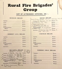
Document, Rural Fire Brigade's Group, c.1950
... Barrie, daughter of Edna and Bon, remembers the fire truck parked... Barrie, daughter of Edna and Bon, remembers the fire truck parked ...From the earliest days of settlement in the shire, residents demonstrated their willingness to band together in times of crisis and need. "Bushfires were always a terrifying prospect and since its establishment in 1935, the local fire brigade (later the Country Fire Authority) fought hard to protect the people, homes and animals of the shire. In 1966, the Mount Cottrell Fire Brigades Group was formed as a way of consolidating the smaller groups around Melton, Rockbank, Toolern Vale, Sydenham, Truganina and Werribee. Its headquarters were established at the home of Ernest ‘Bon’ and Edna Barrie in Ferris Road, Melton. Captain Bon Barrie was a member of the Melton Fire Brigade and elected group and communications officer of the new Mount Cottrell Brigades Group.22 Wendy Barrie, daughter of Edna and Bon, remembers the fire truck parked at their house and her mother operating the fire brigade’s radio. Growing up in the fire station headquarters, Wendy and her siblings learned how to use the radio too, in case of emergencies".Rural Fire Brigade's Group List of Authorised Officers including the captains and lieutenantsemergency services -
Kew Historical Society Inc
Archive (Sub-series) - Subject File, Buildings (Kew), 1964
... , Southesk, Roberts House, Park Hill, Butleigh Wooton, Villa Alba... to the Masonic Hall (Walpole Street), Fernhurst, Southesk, Roberts House ...Various partiesReference, Research, InformationSecondary Values (KHS Imposed Order)Subject file containing newspaper articles/clippings, research and correspondence from and to the Society. The earliest item, dating from 1964 is a letter from the Society to the City of Kew seeking Council support for the use of Ellesmore, 80 Princess Street as a cultural heritage centre. Other items of correspondence relate to the Masonic Hall (Walpole Street), Fernhurst, Southesk, Roberts House, Park Hill, Butleigh Wooton, Villa Alba, D’Estaville, Charleville, Roseneath, Merridale, La Verna, Otira, Raheen, Willsmere, Holy Trinity Church. Some of these letters contain information about construction of the buildings and architects. In addition to this correspondence, the file includes brief undated research notes on the Clock Tower at the Kew Cemetery, Tarring, Southesk, the Alexandra Gardens, Studley House (Burke Hall), Ellesmore, the Masonic Hall, Xavier College, Genazzano, Trinity Grammar, Carey Baptist College, Abbotsford, Fernhurst, Illapa, Madford, Morganville, Otira, Parkhill, Monnington, Field Place, Lalla Rookh, Merridale, Kew Mental Hospital, and D’Estaville.buildings -- kew (vic.), heritage -- kew (vic.)buildings -- kew (vic.), heritage -- kew (vic.) -
 Orbost & District Historical Society
black and white photographs, 1980s? (winter months)
... Joseph's School in the middle distance. Lochiel Park oval, Lochiel... Joseph's School in the middle distance. Lochiel Park oval, Lochiel ...All photographs seem to have been takenfrom the Telecom tower on the corner of Browning and Wolseley Streets in Orbost 3259.1 is a view of the Orbost township looking north-east. The swimming pool and bowling club can be seen in the foreground. 3259.2 is aview looking north-west and showing the tennis courts and clubhouse, the Recreation Reserve oval, the Youth Centre, Historical Museum, Municipal Offices, Senior Citizens clubrooms with the fire station in the foreground. 3259.3 is a view looking south with the Shire of Orbost Municipal offices and Ruskin Street in the foreground. Munro Street can be seen running from Ruskin Street to St Joseph's School in the middle distance. Lochiel Park oval, Lochiel House, the Snowy River and highway bridge are in the background. 3259.4 is a view looking south showing the Club Hotel, C.B.C. Bank in the middle distance and Hoffman's paddock (Forest Park) and the Snowy River beyond. 3259.5 is a view looking north-east over houses. 3259.6 is aview over the main street, Nicholson Street.showing the main shopping precinct. Shop signs for Permewans, Williams Shoes, F.B. Dicken and Orbost Bakery can be seen. 3259.7 is a view looking south west and shows Forest park and beyond towards Bete Bolong.These photographs are detailed pictorial records of the township of Orbost.Seven black / white photographs taken from above a township. Chimney smoke can be seen in the photographs.orbost-township-1980s aerial-photograph-orbost -
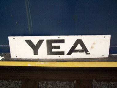 Puffing Billy Railway
Station Sign - Yea
... and the reserve has been turned into The Yea Railway Park consisting... removed and the reserve has been turned into The Yea Railway Park ...Station Sign - Yea Yea Station Opened 16 November 1883 Closed 8 November 1978 Yea is a former railway station in Yea, Victoria, Australia. The tracks have been removed and the reserve has been turned into The Yea Railway Park consisting of the historic railway station and eleven acres of parkland. It has a picnic shelter, barbecue, toilets, playground, skatepark, walking track, community reserve and includes Rotary Park. The station building houses Blackthorn Textiles (a privately run craft shop). Also on the site are the former goods sheds which are available for hire for varied functions. The Yea Country Market is held in the park on the first Saturday of each month and local artists hold an exhibition and sale in the goods sheds each Easter. The site is listed on the Victorian Heritage Register ref: https://en.wikipedia.org/wiki/Yea_railway_station photo at http://vhd.heritagecouncil.vic.gov.au/vhd-images/places/000/078/092.jpg Historic - Victorian Railways Station sign used at Yea StationStation Sign - Yea Metal rectangle Station Name Sign with white enamel back ground and black lettersYeapuffing billy, station sign, yea station -
Kew Historical Society Inc
Archive (Sub-series) - Subject File, Kew Historical Society, Gardens (Kew), 1979
... ), Campion House, Studley Park Road, Raheen, Studley Park Road, Ross...), Campion House, Studley Park Road, Raheen, Studley Park Road, Ross ...Various partiesReference, Research, InformationSecondary Values (KHS Imposed Order)Correspondence and newspaper articles/clippings relating to historic gardens in Kew. The oldest item is a letter from the National Trust Victoria announcing their two-year garden study and seeking information on gardens in Kew. Mavis Rolley, Secretary of the Society, made handwritten notes in response, which are kept in the file. She refers to: the pear trees planted by William Oswin in c. 1845 near what is now the Burke Road Bridge (she notes that a search for the trees at the time of the construction of the Eastern Freeway was unsuccessful), a camellia planted by the Dannocks near the corner of Derby and High Street, a c.1876 pine tree in Field Place, Henty Court, an 1875 Moreton Bay fig at Tarring, Ruyton, a Moreton Bay fig at Roxeth, Trinity Grammar, an 1840s oak tree and a 120-year old olive tree at Fairholme, Barry Street, 1870 pine trees at D’Estaville, Barry Street, trees at Turinville, Barnard Grove, dating to 1846, pine trees dating from 1845-6 on the Willsmere Farm, red gums in Victoria Park, pine trees in the Cemetery dating from the 1860s, trees in the Alexandra Gardens and at Kew Primary School, palm trees at La Verna, Sackville Street dating from the 1890s, the trees and gardens at Ross House (Charleville), and the trees at Merridale, Sackville Street which date from the 1880s, a magnolia at Lalla Rookh. These dates are probably highly contestable. Other handwritten notes from 1979 about significant gardens included: 5 Molesworth Street, Red Bluff - Redmond Street (garden now destroyed), Campion House, Studley Park Road, Raheen, Studley Park Road, Ross House, Cotham Road (Charleville), 7 Adeney Avenue, 20-21 Belmont Avenue, 52 Mary Street, an Edna Walling garden on the corner of Argyle Road and Victor Avenue, Merridale, Sackville Street, Roseneath, and Reno, St John’s Parade.gardens - private - kew (vic), garden design - kew (vic), kew horticultural societygardens - private - kew (vic), garden design - kew (vic), kew horticultural society -
 Bendigo Historical Society Inc.
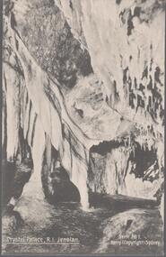
Postcard - Australia, Elliot Collection, 1895 - 1914
... 1045.035 The Heads, Sydney Harbour 1405.036 Hyde Park, Sydney... Hyde Park, Sydney 1105.037 Court House, Bourke 1405.038 Oldham ...Thought to have originated in Austria in 1869, postcards first gained popularity in Australia in the 1890s.They were used to send short messages to friends and family. This collection was generated by Mary Emma Elliot of Talgarno. Talgarno is a rural locality in Victoria, Australia, situated on the southern shoreline of Lake Hume, about 23 km east of Albury-Wodonga. The collection contains postcards from across the world. Mary Emma Sibley was born in Ironbark, Bendigo in 1859. She married James Elliot in 1893 and they settled at “Kelso”, Talgarno. They had two children – Mona and Sibley. Mary Emma Elliot died in Melbourne in 1944, aged 84 years.Australian postcards collected by Mrs. James Elliot between 1898 and 1915. 1405.021 Crystal Palace R I Jenolan 1405.022 Snowball Cave, Lucas, Jenolan, N.S.W. 1405.023 The Great Zig-Zag 1405.024 Sydney Harbour and Botanical Gardens 1405.025 Barren Jack Works 1405.026 Mountain Homes, Illawarra 1405.027 The Weir, Yass 1405.028 Forest Creek Falls, Yass 1405.029 Yass Town 1405.030 Musgrove Point 1405.031 St. Clements Church of England, Yass 1405.032 Watson's Bay, Sydney 1405.033 Coal Mine Gully, Blackheath, N.S. W. 1405.034 Barren Jack, Murrumbidgee River, Yass 1045.035 The Heads, Sydney Harbour 1405.036 Hyde Park, Sydney 1105.037 Court House, Bourke 1405.038 Oldham 1405.039 Thirroul 1405.040 Blake's Exchange Library, Alburypostcards, collecting, collections, talgarno -
 Eltham District Historical Society Inc
Opening of Meruka Childcare Co-operative, Meruka Park, 5 Meruka Dr, Eltham, April 1994
... to create Meruka Park. The house was used for some years... to create Meruka Park. The house was used for some years ...In 1919 J.B. North, a violinist with the then Melbourne Symphonic Orchestra, and Monsieur Leon Lambert, a French architect, who later designed the Glaciarium Ice Skating Rink, purchased three available farms, Looker's, Wright's and Taylor's, approximately 60 acres, the area running along the creek and being bordered by the present day Ryans Road, Karingal Drive and Sherbourne Road. The farms were used for orchards and market gardens. Leon Lambert designed and built two homes on the farm site, one for the North family, ‘Tralford’, and the other, ‘Glen Ellen’, for himself and his wife. The homes were considered as "brother and sister" and they each included in their design an identical bay window in the main living area. "Glen Ellen" originally comprised kitchen, lounge room, inglenook, dining room, bath room and sleepout. Although the home has been extended over the years, much of the original architecture has been retained including timber panelling and three fireplaces. The land was subdivided in approximately 1966 with "Glen Ellen" retaining approximately one half acre of land fronting Meruka Drive. The property then passed from the Charleston family to Gerald and Margaret Sutton in 1976 and again was sold in 1980 and lastly sold again in 1994. The Norths named their house 'Tralford'. According to Marjorie North, the name Meruka was suggested by Alan Gardner and so was apparently not used by the North family. The name appears to be of Indian origin and its connection with the land is not known. ‘Tralford’ stayed in the North family for many years. Eltham Council acquired the house to create Meruka Park. The house was used for some years by the Council as a community arts facility and as emergency accommodation. It fell into disrepair and was demolished about 1990. The Meruka Child Care Centre has been built on the site and incorporates some of the architectural features of the old house. The Co-op was opened in April 1994. The original drive flanked by large old cypress trees remains. These trees are considered to be of local heritage significance and for this reason Meruka Park is covered by a Heritage Overlay under the Nillumbik Planning Scheme. Part of the park has been preserved as habitat for rare local flora. LL's house, named ‘Glen Ellen’, remains in a well-preserved state and fronts Meruka Drive.cr pam sladden, eltham, meruka child care co-operative, meruka house, meruka park -
 Eltham District Historical Society Inc
Opening of Meruka Childcare Co-operative, Meruka Park, 5 Meruka Dr, Eltham, April 1994
... to create Meruka Park. The house was used for some years... to create Meruka Park. The house was used for some years ...In 1919 J.B. North, a violinist with the then Melbourne Symphonic Orchestra, and Monsieur Leon Lambert, a French architect, who later designed the Glaciarium Ice Skating Rink, purchased three available farms, Looker's, Wright's and Taylor's, approximately 60 acres, the area running along the creek and being bordered by the present day Ryans Road, Karingal Drive and Sherbourne Road. The farms were used for orchards and market gardens. Leon Lambert designed and built two homes on the farm site, one for the North family, ‘Tralford’, and the other, ‘Glen Ellen’, for himself and his wife. The homes were considered as "brother and sister" and they each included in their design an identical bay window in the main living area. "Glen Ellen" originally comprised kitchen, lounge room, inglenook, dining room, bath room and sleepout. Although the home has been extended over the years, much of the original architecture has been retained including timber panelling and three fireplaces. The land was subdivided in approximately 1966 with "Glen Ellen" retaining approximately one half acre of land fronting Meruka Drive. The property then passed from the Charleston family to Gerald and Margaret Sutton in 1976 and again was sold in 1980 and lastly sold again in 1994. The Norths named their house 'Tralford'. According to Marjorie North, the name Meruka was suggested by Alan Gardner and so was apparently not used by the North family. The name appears to be of Indian origin and its connection with the land is not known. ‘Tralford’ stayed in the North family for many years. Eltham Council acquired the house to create Meruka Park. The house was used for some years by the Council as a community arts facility and as emergency accommodation. It fell into disrepair and was demolished about 1990. The Meruka Child Care Centre has been built on the site and incorporates some of the architectural features of the old house. The Co-op was opened in April 1994. The original drive flanked by large old cypress trees remains. These trees are considered to be of local heritage significance and for this reason Meruka Park is covered by a Heritage Overlay under the Nillumbik Planning Scheme. Part of the park has been preserved as habitat for rare local flora. LL's house, named ‘Glen Ellen’, remains in a well-preserved state and fronts Meruka Drive.eltham, meruka child care co-operative, meruka house, meruka park, cr. peter graham, peter staples, richard allen, sheryl garbutt, bill penrose -
 Eltham District Historical Society Inc
Opening of Meruka Childcare Co-operative, Meruka Park, 5 Meruka Dr, Eltham, April 1994
... to create Meruka Park. The house was used for some years... to create Meruka Park. The house was used for some years ...In 1919 J.B. North, a violinist with the then Melbourne Symphonic Orchestra, and Monsieur Leon Lambert, a French architect, who later designed the Glaciarium Ice Skating Rink, purchased three available farms, Looker's, Wright's and Taylor's, approximately 60 acres, the area running along the creek and being bordered by the present day Ryans Road, Karingal Drive and Sherbourne Road. The farms were used for orchards and market gardens. Leon Lambert designed and built two homes on the farm site, one for the North family, ‘Tralford’, and the other, ‘Glen Ellen’, for himself and his wife. The homes were considered as "brother and sister" and they each included in their design an identical bay window in the main living area. "Glen Ellen" originally comprised kitchen, lounge room, inglenook, dining room, bath room and sleepout. Although the home has been extended over the years, much of the original architecture has been retained including timber panelling and three fireplaces. The land was subdivided in approximately 1966 with "Glen Ellen" retaining approximately one half acre of land fronting Meruka Drive. The property then passed from the Charleston family to Gerald and Margaret Sutton in 1976 and again was sold in 1980 and lastly sold again in 1994. The Norths named their house 'Tralford'. According to Marjorie North, the name Meruka was suggested by Alan Gardner and so was apparently not used by the North family. The name appears to be of Indian origin and its connection with the land is not known. ‘Tralford’ stayed in the North family for many years. Eltham Council acquired the house to create Meruka Park. The house was used for some years by the Council as a community arts facility and as emergency accommodation. It fell into disrepair and was demolished about 1990. The Meruka Child Care Centre has been built on the site and incorporates some of the architectural features of the old house. The Co-op was opened in April 1994. The original drive flanked by large old cypress trees remains. These trees are considered to be of local heritage significance and for this reason Meruka Park is covered by a Heritage Overlay under the Nillumbik Planning Scheme. Part of the park has been preserved as habitat for rare local flora. LL's house, named ‘Glen Ellen’, remains in a well-preserved state and fronts Meruka Drive.eltham, meruka child care co-operative, meruka house, meruka park, cr. john cohen -
 Eltham District Historical Society Inc
Opening of Meruka Childcare Co-operative, Meruka Park, 5 Meruka Dr, Eltham, April 1994
... to create Meruka Park. The house was used for some years... to create Meruka Park. The house was used for some years ...In 1919 J.B. North, a violinist with the then Melbourne Symphonic Orchestra, and Monsieur Leon Lambert, a French architect, who later designed the Glaciarium Ice Skating Rink, purchased three available farms, Looker's, Wright's and Taylor's, approximately 60 acres, the area running along the creek and being bordered by the present day Ryans Road, Karingal Drive and Sherbourne Road. The farms were used for orchards and market gardens. Leon Lambert designed and built two homes on the farm site, one for the North family, ‘Tralford’, and the other, ‘Glen Ellen’, for himself and his wife. The homes were considered as "brother and sister" and they each included in their design an identical bay window in the main living area. "Glen Ellen" originally comprised kitchen, lounge room, inglenook, dining room, bath room and sleepout. Although the home has been extended over the years, much of the original architecture has been retained including timber panelling and three fireplaces. The land was subdivided in approximately 1966 with "Glen Ellen" retaining approximately one half acre of land fronting Meruka Drive. The property then passed from the Charleston family to Gerald and Margaret Sutton in 1976 and again was sold in 1980 and lastly sold again in 1994. The Norths named their house 'Tralford'. According to Marjorie North, the name Meruka was suggested by Alan Gardner and so was apparently not used by the North family. The name appears to be of Indian origin and its connection with the land is not known. ‘Tralford’ stayed in the North family for many years. Eltham Council acquired the house to create Meruka Park. The house was used for some years by the Council as a community arts facility and as emergency accommodation. It fell into disrepair and was demolished about 1990. The Meruka Child Care Centre has been built on the site and incorporates some of the architectural features of the old house. The Co-op was opened in April 1994. The original drive flanked by large old cypress trees remains. These trees are considered to be of local heritage significance and for this reason Meruka Park is covered by a Heritage Overlay under the Nillumbik Planning Scheme. Part of the park has been preserved as habitat for rare local flora. LL's house, named ‘Glen Ellen’, remains in a well-preserved state and fronts Meruka Drive.eltham, meruka child care co-operative, meruka house, meruka park, rob hauser -
 Eltham District Historical Society Inc
Opening of Meruka Childcare Co-operative, Meruka Park, 5 Meruka Dr, Eltham, April 1994
... to create Meruka Park. The house was used for some years... to create Meruka Park. The house was used for some years ...In 1919 J.B. North, a violinist with the then Melbourne Symphonic Orchestra, and Monsieur Leon Lambert, a French architect, who later designed the Glaciarium Ice Skating Rink, purchased three available farms, Looker's, Wright's and Taylor's, approximately 60 acres, the area running along the creek and being bordered by the present day Ryans Road, Karingal Drive and Sherbourne Road. The farms were used for orchards and market gardens. Leon Lambert designed and built two homes on the farm site, one for the North family, ‘Tralford’, and the other, ‘Glen Ellen’, for himself and his wife. The homes were considered as "brother and sister" and they each included in their design an identical bay window in the main living area. "Glen Ellen" originally comprised kitchen, lounge room, inglenook, dining room, bath room and sleepout. Although the home has been extended over the years, much of the original architecture has been retained including timber panelling and three fireplaces. The land was subdivided in approximately 1966 with "Glen Ellen" retaining approximately one half acre of land fronting Meruka Drive. The property then passed from the Charleston family to Gerald and Margaret Sutton in 1976 and again was sold in 1980 and lastly sold again in 1994. The Norths named their house 'Tralford'. According to Marjorie North, the name Meruka was suggested by Alan Gardner and so was apparently not used by the North family. The name appears to be of Indian origin and its connection with the land is not known. ‘Tralford’ stayed in the North family for many years. Eltham Council acquired the house to create Meruka Park. The house was used for some years by the Council as a community arts facility and as emergency accommodation. It fell into disrepair and was demolished about 1990. The Meruka Child Care Centre has been built on the site and incorporates some of the architectural features of the old house. The Co-op was opened in April 1994. The original drive flanked by large old cypress trees remains. These trees are considered to be of local heritage significance and for this reason Meruka Park is covered by a Heritage Overlay under the Nillumbik Planning Scheme. Part of the park has been preserved as habitat for rare local flora. LL's house, named ‘Glen Ellen’, remains in a well-preserved state and fronts Meruka Drive.eltham, meruka child care co-operative, meruka house, meruka park, irene bogle -
 Eltham District Historical Society Inc
Opening of Meruka Childcare Co-operative, Meruka Park, 5 Meruka Dr, Eltham, April 1994
... to create Meruka Park. The house was used for some years... to create Meruka Park. The house was used for some years ...In 1919 J.B. North, a violinist with the then Melbourne Symphonic Orchestra, and Monsieur Leon Lambert, a French architect, who later designed the Glaciarium Ice Skating Rink, purchased three available farms, Looker's, Wright's and Taylor's, approximately 60 acres, the area running along the creek and being bordered by the present day Ryans Road, Karingal Drive and Sherbourne Road. The farms were used for orchards and market gardens. Leon Lambert designed and built two homes on the farm site, one for the North family, ‘Tralford’, and the other, ‘Glen Ellen’, for himself and his wife. The homes were considered as "brother and sister" and they each included in their design an identical bay window in the main living area. "Glen Ellen" originally comprised kitchen, lounge room, inglenook, dining room, bath room and sleepout. Although the home has been extended over the years, much of the original architecture has been retained including timber panelling and three fireplaces. The land was subdivided in approximately 1966 with "Glen Ellen" retaining approximately one half acre of land fronting Meruka Drive. The property then passed from the Charleston family to Gerald and Margaret Sutton in 1976 and again was sold in 1980 and lastly sold again in 1994. The Norths named their house 'Tralford'. According to Marjorie North, the name Meruka was suggested by Alan Gardner and so was apparently not used by the North family. The name appears to be of Indian origin and its connection with the land is not known. ‘Tralford’ stayed in the North family for many years. Eltham Council acquired the house to create Meruka Park. The house was used for some years by the Council as a community arts facility and as emergency accommodation. It fell into disrepair and was demolished about 1990. The Meruka Child Care Centre has been built on the site and incorporates some of the architectural features of the old house. The Co-op was opened in April 1994. The original drive flanked by large old cypress trees remains. These trees are considered to be of local heritage significance and for this reason Meruka Park is covered by a Heritage Overlay under the Nillumbik Planning Scheme. Part of the park has been preserved as habitat for rare local flora. LL's house, named ‘Glen Ellen’, remains in a well-preserved state and fronts Meruka Drive.eltham, meruka child care co-operative, meruka house, meruka park, cr bob manuell, matthew rodscholler -
 Eltham District Historical Society Inc
Opening of Meruka Childcare Co-operative, Meruka Park, 5 Meruka Dr, Eltham, April 1994
... to create Meruka Park. The house was used for some years... to create Meruka Park. The house was used for some years ...In 1919 J.B. North, a violinist with the then Melbourne Symphonic Orchestra, and Monsieur Leon Lambert, a French architect, who later designed the Glaciarium Ice Skating Rink, purchased three available farms, Looker's, Wright's and Taylor's, approximately 60 acres, the area running along the creek and being bordered by the present day Ryans Road, Karingal Drive and Sherbourne Road. The farms were used for orchards and market gardens. Leon Lambert designed and built two homes on the farm site, one for the North family, ‘Tralford’, and the other, ‘Glen Ellen’, for himself and his wife. The homes were considered as "brother and sister" and they each included in their design an identical bay window in the main living area. "Glen Ellen" originally comprised kitchen, lounge room, inglenook, dining room, bath room and sleepout. Although the home has been extended over the years, much of the original architecture has been retained including timber panelling and three fireplaces. The land was subdivided in approximately 1966 with "Glen Ellen" retaining approximately one half acre of land fronting Meruka Drive. The property then passed from the Charleston family to Gerald and Margaret Sutton in 1976 and again was sold in 1980 and lastly sold again in 1994. The Norths named their house 'Tralford'. According to Marjorie North, the name Meruka was suggested by Alan Gardner and so was apparently not used by the North family. The name appears to be of Indian origin and its connection with the land is not known. ‘Tralford’ stayed in the North family for many years. Eltham Council acquired the house to create Meruka Park. The house was used for some years by the Council as a community arts facility and as emergency accommodation. It fell into disrepair and was demolished about 1990. The Meruka Child Care Centre has been built on the site and incorporates some of the architectural features of the old house. The Co-op was opened in April 1994. The original drive flanked by large old cypress trees remains. These trees are considered to be of local heritage significance and for this reason Meruka Park is covered by a Heritage Overlay under the Nillumbik Planning Scheme. Part of the park has been preserved as habitat for rare local flora. LL's house, named ‘Glen Ellen’, remains in a well-preserved state and fronts Meruka Drive.eltham, meruka child care co-operative, meruka house, meruka park, cr pam sladden, mandy press