Showing 11154 items
matching re-survey
-
 Rutherglen Historical Society
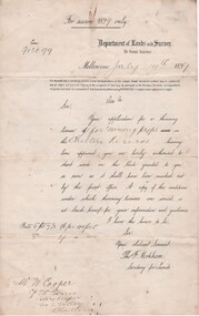
Document - License to thin trees, 1899 (Exact)
Dated July 14th 1899. Sent to Mr W. Cooper / c/o Mr Barrie / Storekeeper / No. 2 Valley / Chiltern / "Copy of Land Act 1896 / Regulations. Chapter XI Thinning Licenses"Document on stiff paper. Letter to Mr W. Cooper granting license to thin trees on a block of land at Chiltern Reserve. On back, copy of Land Act Regulations 1890"Department of Lands and Survey. On Forest Business"license, timber felling, cooper family, forestry, chiltern reserve -
 Whitehorse Historical Society Inc.
Article, Local survey leads the way
Article covering a survey of Nunawading residents aged 70 and over.Article covering a survey of Nunawading residents aged 70 and over will help develop and improve services for the aged. With photo.Article covering a survey of Nunawading residents aged 70 and over. welfare services, quality of life project, haynes, howard, phillips, philippa, britton, di, aged people -
 Ringwood and District Historical Society
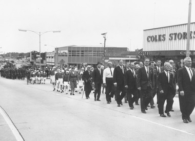
Photograph, Ringwood Clocktower re-opening ceremony march, cnr Maroondah Highway and Wantirna Road, Ringwood, (re-located from previous site at Warrandyte Road), 9/12/1967
Typed below photograph, 'March to new clock tower'. Catalogue card reads, 'Clocktower re-opening. Returned servicemen, Red Cross. Coles Store n/e corner of Maroondah H'way and Ringwood St., S.E.C. State Electricity Office n/w corner H'way and Ringwood St.' -
Ringwood and District Historical Society
Envelope, Packet:4 letters re petrol pumps and storage 1926 to 1939 F. Kenworthy, T. Mathieson
4 letters re petrol pumps and storage 1926 to 1939 F. Kenworthy, T. Mathieson -
 Queenscliffe Maritime Museum
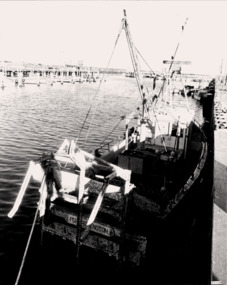
Photograph - Portarlington scallop boat, sunk & re-floated c1982, Scallop boat sunk & re-floated c1982, c1980
Scallop boats in Port Phillip.Re-floated scallop boat PORTARLINGTON4 x B&W photos of re-floated scallop boat PORTARLINGTON's at Queenscliffe Creek.Reverse " see each photo for details. "history, scallop boats, re-floated sunken boats -
 Queenscliffe Maritime Museum
Photograph - B&W photos & news clippings re A T (Dick) Lee, Cuttings & photos re A T Lee, lighthouse keeper, c1977
Lighthouse keepersLighthouse keeper's life & timesB&W photos re A. T. (Dick) Lee, lighthouse keeper, Pt Lonsdale & Queenscliffe.Reverse " See Media scans. "history -
 Queenscliffe Maritime Museum
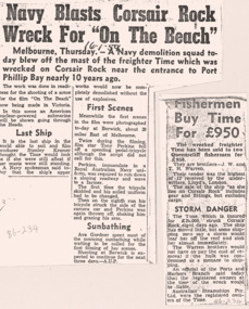
Mixed media - Wreck of the TIME, News articles re the wreck of the TIME, c1949 newspapers
Shipwreck & rescueSS TIME wreck, Corsair Reef & Queenscliffe Lifeboat.News articles, photos, map & report re SS TIME wreck at Corsair Reef c1949Reverse " NIL ".historical references -
 Queenscliffe Maritime Museum
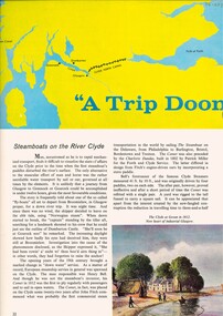
Pamphlet - Clyde River Scotland, Pamphlets, brochures and news article re travelling on the Clyde River Scotland
Clyde River boats ScotlandClyde River boatsColourt & B&W brochures, pamphlets & news article re boats on the Clyde River Scotland.Reverse " NIL "historical references -
 Bendigo Military Museum
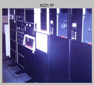
Photograph - Aerotriangulation Production – Army Survey Regiment, Fortuna, Bendigo, c1970s to 1980s
This collection of 14 photos was most likely taken in the 1970s and 1980s in Air Survey Squadron. The PDP 11/70 minicomputer shown in photo .1P was the operating system introduced in 1977 as the mainframe system for the control of the APC4, aerial triangulation block adjustments, SORA OP Analytical Orthophoto control, APR Analytical Terrain Profile Recorder computation, graphics, and general computing. Technicians used the Wild A9 Stereocomparator shown in photo .2P to accurately measure between pass, tie, and survey control points on aerial photographs. The Zeiss D2 Planimat Stereoplotter shown in photos .3P to .4P was used for analytical orthophoto control. It was introduced in 1972-1973 The Zeiss (Jena) Stecometer analytic stereocomparator for air photography shown in photos .5P to .11P and .14P was introduced at Air Survey Squadron in 1963. Aerotriangulation production was expedited using computers for analytical photogrammetric processes. The technician accurately measured between pass, tie, and survey control points on aerial photographs. Wild PUG4 point transfer devices shown in photos .12P to .13P were introduced in c1968 superseding the PUG2 devices. PUG4 devices were used by technicians to stereoscopically view the photography containing the survey control points and the mapping aerial photography. The Control points were transferred from the control photography to the mapping diapositives of aerial photography by drilling their locations into the photographic emulsion.This is a set of 14 photographs of Air Survey Squadron personnel operating aerotriangulation equipment at the Army Survey Regiment at Fortuna, Bendigo, c1970s to 1980s. Photographs .1P to .13P were on 35mm colour slide film and scanned at 96 dpi. Photograph.14P was printed on photographic paper and was scanned at 300 dpi. They are part of the Army Survey Regiment’s Collection. .1) - Photo, colour, c1979, PDP-11 minicomputer. .2) - Photo, colour, c1970s, Unidentified technician operating a Wild A9 Stereocomparator. .3) - Photo, colour, c1970s, Zeiss D2 Planimat Stereoplotter. .4) - Photo, colour, c1970s, Zeiss D2 Planimat Stereoplotter, unidentified technicians. .5) - Photo, colour, c1970s, Zeiss D2 Planimat Stereoplotter, SGT Christopher Wardley. .6) - Photo, colour, c1970s, Zeiss D2 Planimat Stereoplotter. .7) to.9) - Photo, colour, c1970, Zeiss (Jena) Stecometer, unidentified technicians. .10) to.11) - Photo, colour, c1988, SPR Toni Wright operating a Zeiss (Jena) Stecometer. .12) - Photo, colour, c1970s, Wild PUG4 point transfer device, SPR John Shepard. .13) - Photo, colour, c1970s, Wild PUG4 point transfer device, SPR David Edwards. .13) - Photo, colour, c1970s, Wild PUG4 point transfer device, SPR David Edwards. .14) - Photo, colour, c1980, Zeiss (Jena) Stecometer, SGT Bruce Hammond.Some of the equipment is annotated on the frame of the 35mm slides.royal australian survey corps, rasvy, army survey regiment, army svy regt, fortuna, asr, aerotrig, photogrammetry -
 Greensborough Historical Society
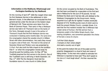
Manuscript, Ivy Medhurst, Information re the Medhurst Whatmough and Partington families by Ivy Medhurst, 24/04/1826
Family memoirs of a descendant of Greensborough pioneer families. Deals mainly with the Medhurst family connection with the Methodist (Wesleyan) Church.Explains the connection between the Medhurst family and the early history of the Wesleyan Church in Melbourne from the 1840s.20 page exercise book with handwritten family memoirs. Title handwritten on cover: Information re the Medhurst Whatmough and Partington families by Ivy Medhurst, daughter of David and Martha.medhurst family, ivy medhurst, methodist church, wesleyan church -
 Federation University Historical Collection
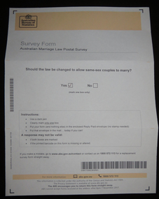
Document, Australian Marriage Law Survey, 2017, 12/09/2017
The vote was made online, so the paper vote papers were kept and donated. Letter from Australian Statistician David W. Kalisch regarding the Australian Marriage Survey, and a photograph of the ballot paper and envelope.australian marriage law, marriage equality, australian bureau of statistics, gay marriage, same sex marriage -
Whitehorse Historical Society Inc.
Document, Heritage survey, 1/10/1994 12:00:00 AM
City of Nunawading Heritage Survey Project [Description]. Context Pty Ltd [Consultants] October 1994.City of Nunawading Heritage Survey Project [Description]. Context Pty Ltd [Consultants] October 1994. (Original and 2 photocopies)City of Nunawading Heritage Survey Project [Description]. Context Pty Ltd [Consultants] October 1994. city of nunawading, historic buildings, context pty ltd -
Whitehorse Historical Society Inc.
Letter - Correspondence, Letter re land tax, Strathdon, 4/08/1961 12:00:00 AM
Letter from State Land Tax office to Mrs Mary Matheson re land on Springvale Road.Letter from State Land Tax office to Mrs Mary Matheson re land on Springvale Road.Letter from State Land Tax office to Mrs Mary Matheson re land on Springvale Road.matheson, mary, strathdon community -
 Queenscliffe Maritime Museum
Magazine - Copy from Professional Fisherman pg.43 Oct.1984, 1984 Article by G Kerr re Wooden Ships - Iron Men of Port Phillip, 1984
Old cray fishing boatsCray fishing boatsMagazine article by G Kerr re Wooden Ships & Iron Men aka Bass Strait CrayfishermenReverse " NIL "historical references -
 Bendigo Military Museum
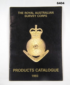
Booklet - PRODUCTS CATALOGUE 1993, RASvy Corps, Royal Australian Survey Corps. Products Catalogue1993, 1993
This Catalogue contains details on the products and capabilities available from the RASvy CorpsA4 Booklet black cover, Survey Corps badge in Gold. Sample maps of all products produced by RASvy Corps 1993rasvy, fortuna -
Kew Historical Society Inc
Archive (Sub-series) - Subject File, Kew Historical Society, HODDLE Survey, 1997
Various partiesReference, Research, InformationSecondary Values (KHS Imposed Order)Photocopied correspondence and maps (surveys) relating to surveys ordered by Robert Hoddle, Government Surveyor. Authors of letters and information include Gwen McWilliam and Jack Hackett. Much of the correspondence relates to the site of the ‘Hoddle Tree’, currently located in the Kew Golf Course. Jack Hackett’s original map is contained in the map drawers in the Society’s archive.kew historical society - archives, kew (vic) - history, robert hoddle - surveyor, hoddle tree - kew (vic), jack hackettkew historical society - archives, kew (vic) - history, robert hoddle - surveyor, hoddle tree - kew (vic), jack hackett -
 Bendigo Military Museum
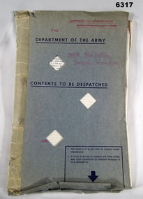
Letter - Mapping correspondence about Papua New Guinea 1970-77, Dept of Natural Resources, Army Survey Regiment, Director of Survey - Army, 1 May 1970 - 8 Aug 1977
20 x Letters, Signals and Documents pertaining to Papua New Guinea (PNG) Mapping during the period 1970-77. These documents were important authoritative documents affecting the production of PNG mapping being produced at the Army Survey Regiment at that time.Foolscap size folder containing 20 x letters/signals pertaining to Papua New Guinea mapping. Several documents both have been numbered #15.Each letter/Signal is numbered 1-20. Document 1- has "recieved" stamp, Document 2- has a note and signature MM Knight WO2, Document 3 - has 788-2-18 ad "Recieved" , Document 5 - has "Sergeant RN Sargeant" annotated, Document -11 has two file numbers and "received" stamp, Document -12 (telephone record) has recipients stamp, date and initials and file ' R750-5-1, Document -13 "received" stamp and initials, Document -15 has "received" stamp and a note "apply after TALASEA", Document -16 includes a diagram, Document -17 "Distribution List" hand written, Document -18 "received" stamp, Document 19 has note and initials, Document -20 "recipients" stamp, note and initials and "Army Survey Regiment" document stamp. royal australian survey corps, rasvy, fortuna, army survey regiment, army svy regt, asr -
 Bendigo Military Museum
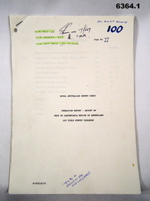
Administrative record - Royal Australian Survey Corps Report on Operation Aright 88 conducted by 1 Field Survey Squadron 1988, 1 Fd Svy Sqn, 9 Feb 1989
Comprehensive Operation Report containing all aspects of OP Aright 88 in the Gulf of Carpentaria region of Queensland. Chapters include: General Information, Operations, Operational Support, Admin and Logistics, Communications, Conclusion and Recommendations. There are four Annexes, Area of Operations, Technical Summary, Nominal Roll, Det 1 Fd Svy Sqn and Air Support Contact Details.Unbound A4 Paper Report held together by a staple top LH corner. Typed pages and diagrams. 6364.1 is copy number 11, 6364.2 is copy number 12 6364.1 is copy number 11, "FOR AIR SURVEY RECORDS" "Tech WO", "Aero Trig", "ADJ", "SGT REES for Records" 6364.2 is copy number 12 "Placed on File and circulated", "Circular Received 15 Feb 1989" on back page. royal australian survey corps, rasvy, fortuna, army survey regiment, army svy regt, asr -
 Bayside Gallery - Bayside City Council Art & Heritage Collection
Map, H.B. Foot, Plan of the Brighton Estate containing 5120 acres, first special survey at Port Phillip, c. 1842
This plan records the Brighton Estate, also known as Dendy's Special Survey. In 1840 Henry Dendy, a farmer in Surrey, England acquired a "Special Survey" from the Commissioners for Land and Emigration which gave him the right to choose land in Port Phillip for the low price of £1 per acre for 5120 acres. Dendy appointed Jonathan Binns Were, as his agent, who later became a partner. Together, Dendy and Were decided on an area 5 miles south from Melbourne, bounded by North Road, East Boundary Road, South Road and to the west by Port Phillip Bay. Their Brighton Estate was first surveyed by T. S. Townsend in May 1841 and was re-surveyed by Robert Hoddle. Dendy and Were were making plans to sell the land and advertised a 30-guinea prize for the best subdivision which was to be divided into a village, marine residences, suburban and cultivation allotments, with the remainder being divided into country sections. The competition was won by H.B. Foot, who planned the village around a reserve and crescents and a 'green belt' forming the town boundary. brighton estate, dendy's special survey, special survey, henry dendy, jonathan binns were, w.b. were, survey, plan, map, brighton, george ward cole, baker's lithographer, hibernian, subdivision, town planning, cartographic material, h.b. foot -
 Anglesea and District Historical Society
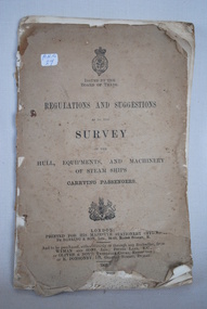
Steam Ship Regulations, Darling & Son Ltd, Regulations and Suggestions as to the Survey, 1905
Book of regulations and suggestions as to the survey of hull, equipments and machinery of steam ships carrying passengers. Dated 1905 which supersedes ed. 1901.ISSUED BY THE BOARD OF TRADE / REGULATIONS AND SUGGESTIONS OF THE HULL, EQUIPMENTS, AND MACHINERY OF STEAM SHIPS CARRYING PASSENGERS / LONDON / PRINTED FOR HIS MAJESTY'S STATIONERY OFFICE BY DARLING & SON LTD 34-40 BACON STREET E / 1905steam ships, regulations -
 Ringwood and District Historical Society
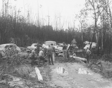
Photograph, Ringwood Rifle Club. Re-building viaduct destroyed in bushfire of January 1962 - Jumping Creek Reserve
Black and white photographTyped on back of photograph- "Ringwood Rifle Club. Re-building viaduct destroyed in bushfires of January 1962. Jumping Creek Reserve". -
 Ringwood and District Historical Society
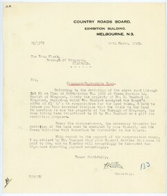
Letter, From Country Roads Board re compensation for road-widening land from Mr Bamford in 1929
1929 saw the establishment of the Ringwood Bowls Club initially located on the land now occupied by the Eastland Shopping Centre. It moved to its current location in Loughnan Road, Ringwood in 1997.From Country Roads Board re compensation for road-widening land from Mr Bamford. Dated 14th March 1929.city of ringwood bowls club, ringwood bowling club, ringwood bowls club, lawn bowls, bowling -
 Ringwood and District Historical Society
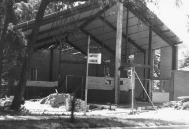
Photograph, Construction of East Ringwood Baptist Church in Dublin Road, Ringwood East prior to re-opening in 1966
East Ringwood Baptist Church in Dublin Road being re-built prior to official opening on Saturday May 14, 1966.Written on back of photograph, "East Ringwood" -
Port Melbourne Historical & Preservation Society
Document, "Waterfront Re-Structure - A calculated attack by Capital on Labor", 1980s
"Waterfront Re-Structure - A calculated attack by Capital on Labor" Article written late 1980s and authorized by H Bocquet and G Stauntonpiers and wharves - waterside workers, societies clubs unions and other organisations, public action campaigns, australian labor party, alp, actu, h bocquet, g staunton, beris campbell -
Stawell Historical Society Inc
Map, Underground Survey of the Principal Mines of Stawell 1879, 1879
Pleasant Creek & Newington, Prince Patrick, Prince Alfred, Pioneer and Galatea, Pleasant Creek Cross Reef No. 1&2, Magdala, Old Shaft, Extended Cross Reef, Crown Cross, Great Northern, Sloanes & Scotchmans, South Cross, 10 & 11 United Scotchmans South Cross, Scotchmans Shafts, North Scothmans, West Scotchmans, Emerald Isle & Rose of Denmark, Albion, South Scotchmans, Newington & Pleasant Creek, Pleasant Creek Cross Reef, Moonlight, Extended Cross Reef, Crown cross United, Great Northern ShaftVery large Map on cloth backing, showing cross sections of mines.Surveyed by H.C. Bates. Drawn by Arthur Edwards. October 30th 1879. Scales 120 feet to an inchmining, gold -
 Victorian Aboriginal Corporation for Languages
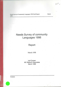
Book, Judi Cooper, Needs survey of community languages 1996 : report : March 1998, 1998
Report of Needs Survey of Community Languages, including, Methodology, Victoria, NSW, Queensland, Torres Strait Islanders, Western Australia, Northern Territory and summary. -
Bendigo Historical Society Inc.
Map - MANDURANG, 8/10/1887
... Re-survey ...Parish of Mandurang, County of Bendigo. Traced from a re-survey of the Parish of Mandurang by Mr. Geo. Black 8/10.1887 ( number 158 in Map Cupboard 1)map, bendigo, parish plan, mandurang, re-survey, couny of bendigo -
 Ringwood and District Historical Society
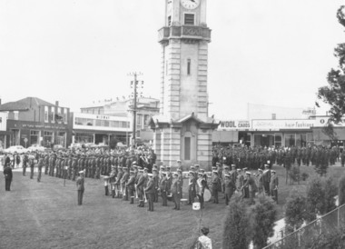
Photograph, Ringwood Clocktower re-opening ceremony, Cnr Maroondah Hwy and Wantirna Road, Ringwood - December 1967
Typed below photograph, 'Clock tower ceremony in new position'. Catalogue card reads, 'Clock tower re-opening, December 1967'. -
 Melbourne Tram Museum
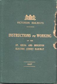
Document - Rule Book, Victorian Railways, "Victorian Railways Instructions re Working of the St Kilda and Brighton Electric Street Railway", 1926/27
Issued to employees of the VR St Kilda to Brighton electric street railway, superseding previous copies. The line closed in 1956. Note the spelling of the word "employe" with an accent over the e - an acceptable practice in Victoria at the time - a US based spelling. Book scanned into multiple parts. See Reg Item 3508 for a "Supplement to the Book of Instructions re the working of the St Kilda and Brighton Electric Street Railway, dated 1/1/1915", item 7518 for a June 1907 version, and 7580 for instructions issued in 1911.Demonstrates a Victorian Railway Rule book for electric tramways or Street Railways.Rule Book - 156 pages, five sewn sections within a green coloured Rexene heavy card with glued endpapers with the title "Victorian Railways Instructions re Working of the St Kilda and Brighton Electric Street Railway" and "1927" in gold block. Dated 1 June 1926. Has a table of contents and index - gives definitions - "trams" vs "street railways", general instructions, hand signs, working of cars, working of traffic over single and double line, staff and ticket systems, air brakes, permanent way, overhead, fares, appeals of employees against penalty and electric shock.Copy 3 has stamp of the "Westinghouse Brake Inspector" and "Lloyd Rogers" in ink on the inside front cover. On page 94 and 95 has notes in pencil about the air braking system - may have been for a following issue.trams, tramways, victorian railways, vr, st kilda brighton, rules, employees, safeworking -
 Ballarat Tramway Museum
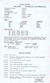
Document - Roster, Ballarat Tramway Preservation Society (BTPS), "Duty Roster Re-opening Day 1st February 1975", Jan. 1975
Duplicated sheet of foolscap paper, titled "Ballarat Tramways / Duty Roster Re-opening Day 1st February 1975" outlining the arrangements for the re-opening celebrations. Gives details of officers, crews, time of duty, official crews, trams operated and operating programme, including the ARE visit. 2nd copy added 5/5/06.trams, tramways, btps, opening, celebrations, rosters